Natural Resources of Chatham
|
|
|
- Conrad Little
- 5 years ago
- Views:
Transcription


1 Natural Resources of Chatham Andrew Meyer, Beth Roessler, Karen Strong, and Emily Vail NYSDEC Hudson River Estuary Program and Cornell University Presentation to Town of Chatham, December 6, 2012


2 The Hudson River Estuary Program Chatham Ensure clean water; Protect and restore fish and wildlife habitats; Provide recreation in and on the water; Adapt to climate change; and Conserve the scenic landscape.

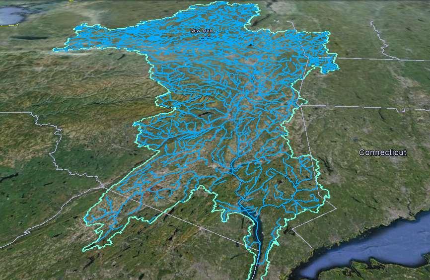
3 Hudson River Watershed Entire watershed ~ 13,500 sq. mi.
4
5 Outline Role of local governments The Natural Resource Summaries How you can use the Summaries Where to go for more information

6 Local government has a critical role in managing water and wildlife

7 How local governments manage water and wildlife Comprehensive plan Open space plan Zoning Town ordinances Natural resource inventory Critical environmental areas Project review SEQRA Stormwater regulations

8 Healthy, natural systems provide benefits to our communities: water quality and quantity flood control clean air carbon storage recreation scenery forest products ecosystem services
9 Images courtesy Dodson Associates, Ltd. And Behan Planning Associates, Inc A small town in upstate New York
10 Images courtesy Dodson Associates, Ltd. And Behan Planning Associates, Inc Buildout under current zoning

11 More roads, roofs, and driveways mean more runoff Less wildlife habitat, more fragmentation Changes the way water moves across the landscape Loss of streamside vegetation More stream crossings, barriers to fish, flooding risk More road salt degrades water quality Changes habitat promotes weedy species Limit animal migrations More negative wildlife-human interactions More pressure on aquifer, impact from septics Reduce hunting and recreation opportunities Images courtesy Dodson Associates, Ltd. And Behan Planning Associates, Inc Many impacts on water and wildlife
12 Rivers and Streams Wetlands & stream corridors Forests and natural area connections Working Landscapes Identify important resources Cultural & Historic Resources Trails and Greenways Images courtesy Dodson Associates, Ltd. And Behan Planning Associates, Inc

13 Images courtesy Dodson Associates, Ltd. And Behan Planning Associates, Inc A buildout that reduces pressure
14 Note: this is an idealized cartoon. By working toward this ideal, you can reduce pressure. Images courtesy Dodson Associates, Ltd. And Behan Planning Associates, Inc A buildout that reduces pressure


15 Outline Role of local governments The Natural Resource Summaries How you can use the Summaries Where to go for more information

16 What is a Natural Resource Summary? Local data from Farmscape Ecology at Hawthorne Valley Farm Summarizes existing information gleaned from (mostly) state data Description Table Map General conservation principles References
17 Please Note! Primarily for planning purposes Maps have limitations (e.g., scale) Raise questions for project review Will not tell you if a permit from NYSDEC is needed

")
18 What is in a Habitat Summary? Landscape Context Major Natural Features Streams and Watersheds Large Forests (200+ acres) Wetlands Calcium-rich bedrock Grasslands (text only) Semi-natural areas (text only)

19 What is in a Habitat Summary? Tables and Links
20 What is in a Water Resources Summary? Land Cover Aquifers Floodplains and Riparian Buffers Waterbody Classification, Assessments, and Impairment Stormwater Management SPDES Permits and Wastewater Aquatic Barriers

21 What is in a Water Resources Summary? Background Information for Chatham Tables Maps References
22 What is in a Water Resources Summary? Background Information for Chatham Tables Maps References


23 Recommended Conservation Guidelines Identify natural areas early in the planning process. Avoid and minimize disturbance to natural areas. Preserve links between natural areas with broad connections. Direct development toward altered or least sensitive areas. Preserve farmland potential and working forests.
24 Outline Role of local governments The Natural Resource Summaries How you can use the Summaries Where to go for more information

25 Area of concern

26 Compatible with protection of our groundwater? More detailed information?

27 Species of concern?

28 Large forests that could remain connected?

29 Important floodplain forest habitats? Trout stream?

30 Trout stream? Does it require a permit?

31 Local water quality?

32 Why? Requires increased stormwater protection?
33 Questions raised, answers provided Aquifer concerns? compatible land uses
34 Questions raised, answers provided Aquifer concerns? compatible land uses Important habitats? Species of concern and floodplain forests
35 Questions raised, answers provided Aquifer concerns? compatible land uses Important habitats? Species of concern and floodplain forests Protected Stream? Contact the DEC
36 Questions raised, answers provided Aquifer concerns? compatible land uses Important habitats? Species of concern and floodplain forests Protected Stream? Contact the DEC Impaired waterbody? Stormwater management concerns
37 How can a town use the Summaries? Comprehensive Plan Open Space Plan Zoning Town ordinances Natural Resource Inventory Comply with stormwater regulations SEQRA Environmental Assessment Forms Critical Environmental Areas Conservation Advisory Councils Project review (case study)
 support its determination with reasoned elaboration Photo: L. Heady")
38 SEQRA requires lead agencies to take a hard look at environmental impacts 1) identify relevant areas of environmental concern 2) thoroughly analyze those areas to determine if the action may have a significant adverse impact 3) support its determination with reasoned elaboration Photo: L. Heady

39 The summaries can help you with several questions on the new Environmental Assessment Forms

40 Critical Environmental Areas A specific geographic area designated by a state or local agency because it has exceptional or unique environmental or cultural characteristics valued by the community. Hogback Hill CEA, Hyde Park


41 In Rosendale, the Conservation Advisory Council prepared a Natural Resource Inventory


42 In Rhinebeck, the Conservation Advisory Council helps the Planning Board
43 Outline Role of local governments The Natural Resource Summaries How you can use the Summaries Where to go for more information
44 Where can I get more information? Tables and Links

45 Helping people enjoy, protect, and revitalize the Hudson River Estuary and its Valley Karen Strong Biodiversity Outreach Coordinator Andrew Meyer Shoreline Conservation Specialist Emily Vail Watershed Specialist NYSDEC Hudson River Estuary Program & Cornell University
Natural Resources and Climate Resiliency in Germantown
 Natural Resources and Climate Resiliency in Germantown Ingrid Haeckel, Andrew Meyer, and Elizabeth Murphy NYSDEC Hudson River Estuary Program and Cornell University Presentation to the Town of Germantown,
ANCR INDIVIDUAL RESPONSES SUMMARY: 2/11/04 WATER RESOURCES GOALS AND OBJECTIVES
 ANCR INDIVIDUAL RESPONSES SUMMARY: 2/11/04 WATER RESOURCES GOALS AND OBJECTIVES Goal 1: Protect the health and safety of the Dane County population. a. Prevent development that may have an adverse effect
Chapter 4 Watershed Goals and Objectives
 Chapter 4 Watershed Goals and Objectives Eight (8) long-term watershed goals have been developed by the NEW Watershed Advisory Group (WAG) after consideration of discussions held during monthly watershed
Environmental Resource Inventories. What are ERIs? Significance of information How to use them
 Environmental Resource Inventories What are ERIs? Significance of information How to use them Environmental Resource Inventory - ERI Compiled by the environmental commission Information about the natural
Biodiversity Conservation
 SITE PLAN REVIEW & BIODIVERSITY CONSERVATION Hudsonia Ltd. Session 3 of a workshop series sponsored by the Teatown Lake Reservation Site Plan Review & Biodiversity Conservation Biodiversity and Ecosystem
Cannon River One Watershed, One Plan. POLICY COMMITTEE MEETING January 10, 2018 Rice County Government Center Faribault, MN
 Cannon River One, One Plan POLICY COMMITTEE MEETING January 10, 2018 Rice County Government Center Faribault, MN TASK Task 1. Aggregate Existing Physical & Spatial Data 1A. Create project maps 1B. Meeting
Pennichuck Brook Watershed Buildout Analysis December 2003
 INTRODUCTION The Pennichuck Brook watershed (Figure 1) includes approximately 17,700 acres within the communities of Amherst, Hollis, Merrimack, Milford and Nashua and is the primary drinking water supply
Prioritizing Climate Change Impacts and Action Strategies
 Prioritizing Climate Change Impacts and Action Strategies Chesapeake Bay Program STAC December 8, 2015 2014 Chesapeake Bay Agreement CLIMATE RESILIENCY GOAL: Increase the resiliency of the Chesapeake Bay
Watershed Planning Basics
 1 Watershed Planning Basics Emily Vail Hudson River Estuary Program, NYS Department of Environmental Conservation NYS Water Resources Institute at Cornell University May 19, 2016 2 Presentation Outline
SECTION 1 - INTRODUCTION
 SECTION 1 - INTRODUCTION 1.1 Watersheds and Their Importance A watershed is an area of land that drains water into a specific pond, stream or river for which it is named. For example the Hudson River watershed
Water and Watersheds. Data Maps Action
 Water and Watersheds Data Maps Action What is the Wildlife Action Plan? Restore rare wildlife and habitats. Keep common species common. 2015 Revision: Partners in Conservation Science 2015 Revision Data
Chapter 10 Natural Environment
 Chapter 10 Natural Environment Existing Conditions The Natural Environment Element addresses the protection, conservation, preservation, and restoration of the natural resources the Bayview Ridge Subarea,
Prioritizing Local Action. Strengthening the Resilience of the Taunton River Watershed
 Prioritizing Local Action Strengthening the Resilience of the Taunton River Watershed No Really, We re Here to Help 6/12/14 Healthy and Resilient Taunton Watershed Project EPA s Healthy Watershed Program
Environmental Check List Georgia Environmental Policy Act
 Environmental Check List Georgia Environmental Policy Act Project No. : Project Name: GEORGIA IS AREA AFFECTED? IF AFFECTED, HOW SEVERELY? AREA/CATEGORY NO YES UNKNOWN MINOR MEDIAN MAJOR UNKNOWN 1. Wetlands
STREAM AND BUFFER AREA PROTECTION/RESTORATION
 STREAM AND BUFFER AREA PROTECTION/RESTORATION AMENDMENT OPTIONS TO STRENGTHEN POLICY IN HEADWATERS AREAS DRAFT SUBSEQUENT TO THE JANUARY 25, 2007 MEETING OF THE PLANNING COMMISSION ENVIRONMENT COMMITTEE
Hudson River Comprehensive Restoration Plan A Plan to Restore and Revitalize the Hudson River
 Hudson River Comprehensive Restoration Plan A Plan to Restore and Revitalize the Hudson River Bear Mountain State Park Carl Heilman II January 2015 Regional Information Sessions Welcome Andy Peck Freshwater
Wetland and Watershed Management Planning FAQ
 Wetland and Watershed Management Planning FAQ Jon Kusler, Ph.D., Esq., Jennifer Brady-Connor, Nan Stolzenburg Association of State Wetland Managers 2001 This summary was prepared for the Institute for
EXECUTIVE SUMMARY DES PLAINES RIVER WATERSHED-BASED PLAN WHY A WATERSHED-BASED PLAN? WHAT IS A WATERSHED?
 Des Plaines River Watershed-Based Plan EXECUTIVE SUMMARY June 2018 EXECUTIVE SUMMARY DES PLAINES RIVER WATERSHED-BASED PLAN WHY A WATERSHED-BASED PLAN? Water is elemental to our lives. Plants and animals,
How is Water Quality Affected by Land Use?
 Watershed Connections Lesson Les4 3 How is Water Quality Affected by Land Use? Overview What are the benefits of a healthy watershed? What are examples of land uses? What types of pollution can come from
COUNTY COMPREHENSIVE PLAN
 86 : Policy Statement Lewis County has an abundance of natural resources, including water, wind, soils, and wildlife. Together with our citizens, they form a unique ecosystem that must be preserved and
BMP 5.4.2: Protect /Conserve/Enhance Riparian Areas
 BMP 5.4.2: Protect /Conserve/Enhance Riparian Areas The Executive Council of the Chesapeake Bay Program defines a Riparian Forest Buffer as "an area of trees, usually accompanied by shrubs and other vegetation,
Sustainable Recreation
 Sustainable Recreation Sustainable Recreation An enjoyable way to be healthy, spiritual, and contribute to economic development while conserving resources for future generations. Sustainable Recreation
ELK RAPIDS TOWNSHIP WATER QUALITY ACTION PLAN
 ELK RAPIDS TOWNSHIP WATER QUALITY ACTION PLAN Elk-River-Chain-of-Lakes Gaps Analysis Project The Watershed Center Grand Traverse Bay Tip of the Mitt Watershed Council Michigan Department of Natural Resources
District 12 - Lucas County Natural Resources Conservation Council Scoring Methodology =========================
 Project Name: Applicant: Project Scoring Summary 0 Part II Score: 0 of 44 points possible 0 Part III Score: 0 of 40 points possible 0 Part IV Score: 0 of 17 points possible Total Project Score: 0 of 101
Mohawk River Basin Research Initiative
 Mohawk River Basin Research Initiative 2014-2016 In 2009 the New York Ocean and Great Lakes Ecosystem Council issued a report entitled Our Waters, Our Communities, Our Futures which recommended an ecosystem-based
Lake Creek Watershed Management Plan Public Meeting. Arrowhead Lake May 3, :00 PM
 Lake Creek Watershed Management Plan Public Meeting Arrowhead Lake May 3, 2018 6:00 PM Agenda I. Welcome and Introductions II. III. IV. Watershed Basics Overview of Lake Creek Watershed Elements of a Successful
Support legislation that will protect the quantity of water in Lake Erie
 Specific Regional Priorities Each of Pennsylvania s major drainage basins has an array of individual characteristics that distinguish it from other regions of the state. These include diverse geographic
Grand Traverse Bay Watershed Protection Plan:
 Grand Traverse Bay Watershed Protection Plan: An Overview Sarah U Ren Program Director The Watershed Center 231-935-1514, suren@gtbay.org The Grand Traverse Bay Watershed 973 square miles Bay Volume =
SHORELINE INVENTORY AND RESTORATION PLANNING
 CHAPTER 3 SHORELINE INVENTORY AND RESTORATION PLANNING A. PURPOSE OF THE SHORELINE INVENTORY AND CHARACTERIZATION A first step in the comprehensive Master Program update process is development of a shoreline
Grand Traverse Bay Watershed Protection Plan:
 Grand Traverse Bay Watershed Protection Plan: An Overview Sarah U Ren Program Director The Watershed Center 231-935-1514, suren@gtbay.org What is a Watershed? A watershed is an area of land that captures
Site Plan and Subdivision Review
 Site Plan and Subdivision Review Municipal Land Use Framework Environmental Resource Inventory Master Plan Zoning Land Use Regulation Ordinance requirements for each zone Lot size, setbacks parking, cluster
Phase III Watershed Implementation Plans
 Phase III Watershed Implementation Plans Including programmatic outcomes in your planning to provide co-benefits for your community and reduce pollution Rachel Felver Chesapeake Bay Program Director of
Unify efforts to address water resources for the Big Sky area and surrounding zone of influence in three co-equal water resources focus areas:
 EXECUTIVE SUMMARY The Big Sky Sustainable Water Solutions Forum (Water Forum) is a community-based, collaborative approach building a unified vision for future Big Sky water resources management to maintain
How Much Habitat Is Enough? How Much Disturbance is Too Much?
 How Much Habitat Is Enough? How Much Disturbance is Too Much? Jocelyn Sherwood Canadian Wildlife Service - Ontario January 27 th, 2017 Page 2 April 19, 2017 Page 3 April 19, 2017 Grasslands Forest Wetlands
Surface Water. Solutions for a better world
 1 Surface Water Solutions for a better world Our Surface Water Services Expertise Growing worldwide awareness of water scarcity has encouraged water preservation programs, better irrigation techniques
BANKS TOWNSHIP WATER QUALITY ACTION PLAN
 BANKS TOWNSHIP WATER QUALITY ACTION PLAN Elk-River-Chain-of-Lakes Gaps Analysis Project The Watershed Center Grand Traverse Bay Tip of the Mitt Watershed Council Michigan Department of Natural Resources
Stormwater Management Tools: Real-Life Solutions for a Resilient Community Riparian Corridor Protection
 Stormwater Management Tools: Real-Life Solutions for a Resilient Community Riparian Corridor Protection Montgomery County Planning Commission October 24, 2013 Eric Jarrell, Assistant Section Chief, Community
NWI 2007 NEW TOOLS AND TECHNOLOGIES. Ralph Tiner Wetland Ecologist U.S. Fish & Wildlife Service National Wetlands Inventory Program
 NWI 2007 NEW TOOLS AND TECHNOLOGIES Ralph Tiner Wetland Ecologist U.S. Fish & Wildlife Service National Wetlands Inventory Program WHERE WE ARE GOING Improved mapping Expanded wetland classification Preliminary
STAFF REPORT FOR POLICY PLAN AMENDMENT S10-CW-1CP
 STAFF REPORT FOR POLICY PLAN AMENDMENT S10-CW-1CP EXECUTIVE SUMMARY This Plan Amendment would serve to clarify policy guidance regarding circumstances under which proposals for disturbances to Environmental
CHAPTER 1: INTRODUCTION. Background: Shoreline Management in Washington State
 September 19, 2007 CHAPTER 1: INTRODUCTION Background: Shoreline Management in Washington State The Shoreline Management Act In 1971, the Washington State Legislature, in response to a citizens initiative,
OurFuture. Protecting. March Ontario Provincial Plans and Conservation Authorities
 Protecting OurFuture Ontario Provincial Plans and Conservation Authorities March 2015 Greenbelt Plan I Niagara Escarpment Plan I Growth Plan for the Greater Golden Horseshoe I Oak Ridges Moraine Conservation
How Much Habitat is Enough?
 How Much Habitat is Enough? Canadian Wildlife Service 2017 Third Edition Page 2 April 19, 2017 Grasslands Forest Wetlands Riparian & Watershed Page 3 April 19, 2017 Significant impairment in stream At
ATTACHMENT 1 GEPA CHECKLIST & Historical Archeological & Natural Heritage Preservation Documents
 ATTACHMENT 1 GEPA CHECKLIST & Historical Archeological & Natural Heritage Preservation Documents INTRODUCTION The 1991 Session of the Georgia General Assembly passed Senate Bill 97, as amended, and it
Water Quality Improvement Projects and Engineering Planning Grant. April 17, 2018
 1 Water Quality Improvement Projects and Engineering Planning Grant April 17, 2018 Water Quality Improvement Project (WQIP) Program 2 3 Overview Competitive, statewide implementation grant Addresses documented
Leveraging Resources for Implementing a Successful Nonpoint Source Grant Project
 Leveraging Resources for Implementing a Successful Nonpoint Source Grant Project Nathaniel Sajdak Watershed Director Sussex County Municipal Utilities Authority Wallkill River Watershed Management Group
Appendix E : Guidelines for Riparian Buffer Areas
 Appendix E : Guidelines for Riparian Buffer Areas This document should be read in conjunction with the CRCA Planning Policy. 1.0 PURPOSE The purpose of this document is to summarize the recommendations
FACTSHEET INTRODUCTION. help rebalance the water cycle, mitigate the effects of climate change and improve human health and livelihoods.
 1 FACTSHEET INTRODUCTION World Water Day, on 22 March every year, is about focusing attention on the importance of water. This year s theme, Nature for Water, explores nature-based solutions (NBS) to the
Applying Ecosystem Services to Collaborative Forest Management Elk River Public Meeting
 Applying Ecosystem Services to Collaborative Forest Management Elk River Public Meeting Nikola Smith Ecologist and Ecosystem Services Specialist U.S. Forest Service Port Orford City Hall February 2, 2017
State of the Waters ~ Overview
 Chapter 1 Page 2 Background & Purpose State of the Waters ~ The waters of Clallam County are varied, in some cases provide abundant resources for fish, wildlife and humans. In others, their quality has
Maitland Valley WATERSHED
 Maitland Valley WATERSHED Report Card 2018 Maitland Conservation has prepared this report card as a summary of the state of your forests, wetlands, and water resources. WHERE ARE WE? We are one of 36 Conservation
Introducing Act 64 - the Vermont Clean Water Act - and Vermont s Clean Water Goals
 Introducing Act 64 - the Vermont Clean Water Act - and Vermont s Clean Water Goals Marli Rupe, DEC Clean Water Initiative Program Asst. Manager February 22, 2016 Clean Waters are a Critical Community Asset
Community Benefits of Land Restoration
 Community Benefits of Land Restoration Introducing Green Infrastructure for Coastal Resilience Matt Fulda, Acting Director Monroe May 23 rd, 2017 Avery Point Campus, University of Connecticut Easton Trumbull
3 Baseline and Existing Conditions
 1 2 3 4 5 6 7 8 9 10 11 12 13 14 3 Baseline and Existing Conditions The effective date of the VSP legislation is July 22, 2011. This is also the date chosen by the legislature as the applicable baseline
TAC CHARRETTE WORKBOOK Ecosystem Management and Sustainable Forestry Practices
 For Discussion Purposes TAC CHARRETTE WORKBOOK Ecosystem Management and Sustainable Forestry Practices NEW JERSEY HIGHLANDS COUNCIL March 28, 2006 1 Overview of RMP Goals and Structure NEW JERSEY HIGHLANDS
COMMUNITY ENVIRONMENTAL MANAGEMENT
 COMMUNITY ENVIRONMENTAL MANAGEMENT TIER 1 SURVEY of COMMUNITY ENVIRONMENTAL CONCERNS INSERT MAP OF PROJECT AREA HERE CONTACT INFORMATION Last Name: First Name: Title: Entity/Organization Name: Name of
CHATHAM PARK EXCEPTIONAL DESIGN EVALUATION
 CHATHAM PARK EXCEPTIONAL DESIGN EVALUATION 1 Chatham Park Basics 7,600 Acre Mixed Use Development 22,000 New Residences 22 Million Square Feet Commercial Space 60,000 Jobs 2,000+ Acres Open Space Estimated
the snapshot version
 the snapshot version 2012 Update Prepared by: Morro Bay National Estuary Program Morro Bay, California Morro Bay National Estuary Program The Morro Bay National Estuary Program works to protect and restore
Local Wetland Protection in a Changing Climate. Michigan Inland Lakes Convention May 1, 2014
 Local Wetland Protection in a Changing Climate Michigan Inland Lakes Convention May 1, 2014 LIAA is a Section 501(c)3 nonprofit corporation created in 1993 to stimulate & support greater civic engagement.
2013 Water and Watershed Conference Plymouth State University March 22, Chris Skoglund
 New Hampshire s Watersheds at a Crossroads Coordinating a Response to Climate Change, Population Growth and Land-Use Change Using the DPSIR Model 2013 Water and Watershed Conference Plymouth State University
Building Resilient Communities - Low Impact Development and Green Infrastructure Strategies
 Building Resilient Communities - Low Impact Development and Green Infrastructure Strategies October 24, 2013 Bridgewater State University E. Heidi Ricci Senior Policy Analyst Mass Audubon Shaping the Future
5. Environmental Stewardship
 5. Environmental Stewardship Introduction Environmental stewardship is a priority for Fort Wayne and Allen County. It is also an overlapping issue that must be dealt with on a variety of policy and planning
9/4/2013 CHAPTER 4 ECOLOGY AND GEOLOGY. Ecosystem. Ecology & Geology Linkage. Fundamental Ecology Terms. Natural Service Functions of Ecosystems
 CHAPTER 4 ECOLOGY AND GEOLOGY Ecology & Geology Linkage Ecology Study of relationships between living things and their environments; the study of control factors over the distribution, abundance, and health
VEGETATIVE, WATER, FISH AND WILDLIFE RESOURCES POLICIES
 VEGETATIVE, WATER, FISH AND WILDLIFE RESOURCES POLICIES The County will: GOALS AND OBJECTIVES 1.1 Conserve, Enhance, Protect, Maintain and Manage Vegetative, Water, Fish and Wildlife Resources Promote
Integrating the Protection of Healthy Waters in Tribal Clean Water Act Section 319 and other Water Quality Programs
 Integrating the Protection of Healthy Waters in Tribal Clean Water Act Section 319 and other Water Quality Programs August 18, 2016 Steve Epting, US EPA Headquarters 1 Today s Talk Defining healthy watersheds
Goose Creek Watershed Assessment Summary October 2003
 Goose Creek Watershed Assessment Summary October 2003 The Goose Creek Watershed The Goose Creek watershed is 385 square miles, covering nearly half of Loudoun County and one-quarter of Fauquier County
The total population of the township is 9,942 (2015 Five-Year American Community Survey [ACS]). The median household income is over $109,000.
![The total population of the township is 9,942 (2015 Five-Year American Community Survey [ACS]). The median household income is over $109,000.](/thumbs/72/67990406.jpg "The total population of the township is 9,942 (2015 Five-Year American Community Survey [ACS]). The median household income is over $109,000.") East Bradford Township, Pennsylvania Motivated by watershed impairment caused by suburban development over the past 30 years, a township with a full slate of water quality improvement programs looks outside
East Bradford Township, Pennsylvania Motivated by watershed impairment caused by suburban development over the past 30 years, a township with a full slate of water quality improvement programs looks outside
Table 1. Relationship between critical areas and key functions. Shaded areas represent functions associated with each critical area. Storage.
 Flow Storage Nutrients Temperature Bacteria Contaminants Cowlitz County Voluntary Stewardship Program 4 Goals, Benchmarks, Strategies and Indicators 4.1 Approach Goals and Benchmarks Critical Areas Functions
CLEARWATER TOWNSHIP WATER QUALITY ACTION PLAN
 CLEARWATER TOWNSHIP WATER QUALITY ACTION PLAN Elk-River-Chain-of-Lakes Gaps Analysis Project The Watershed Center Grand Traverse Bay Michigan Department of Environmental Quality July 2011 Purpose The Grand
TABLE OF CONTENTS. Introduction. Lower Platte South NRD Past and Present 1. Map of Lower Platte South NRD 2. Vision for the Future 3.
 TABLE OF CONTENTS Introduction ii Lower Platte South NRD Past and Present 1 Map of Lower Platte South NRD 2 Vision for the Future 3 Vision Table 5 i INTRODUCTION The Master Plan is the document that expresses
Bylaw , being "Official Community Plan Bylaw, 2016" Schedule "A" 5Improve. Natural + Built Systems
 Bylaw 2600-2016, being "Official Community Plan Bylaw, 2016" Schedule "A" 5Improve Natural + Built Systems Vision Abbotsford will become both more city and more country, where the city becomes more urban
Management Objectives and Targets
 Management Objectives and Targets As part of the Yampa River Stream Management Plan, the community of Steamboat Springs developed management objectives for the reach of the Yampa River near Steamboat Springs.
Hudson River Watershed Management and Issues: A Watershed Dinner Story
 Hudson River Watershed Management and Issues: A Watershed Dinner Story Westchester Water Works Conference October 7, 2013 Outline Quick Estuary Program Overview Watershed Observations and Characterization
I I I I I I I I I I I I I COMPREHENSIVE PLAN IIA-1
 COMPREHENSVE PLAN A-1 1 1 1 1 Comprehensive Plan: Elk County, Pennsylvania A. COMPREHENSVE PLAN GOALS AND OBJECTVES A.l ntroduction The following statement of goals and objectives is an expression of the
Buffalo Creek Watershed-Based Plan EXECUTIVE SUMMARY
 Buffalo Creek Watershed-Based Plan EXECUTIVE SUMMARY Prepared for Buffalo Creek Clean Water Partnership By Cardno August 2015 What you will find inside this Executive Summary 1. Introduction 2. Purpose
Town of Cortlandt Master Plan Chapter 4 Natural Resources 7/09/04
 TOWN OF CORTLANDT MASTER PLAN CHAPTER 4: NATURAL RESOURCES A. INTRODUCTION GOAL: Protect and preserve environmentally sensitive and critical areas. Cortlandt is blessed with natural resources that are
NEW JERSEY HIGHLANDS COUNCIL
 NEW JERSEY HIGHLANDS COUNCIL RELEASE OF PRELIMINARY TECHNICAL INFORMATION FOR THE REGIONAL MASTER PLAN June 2006 June 2006 Preliminary Information Release June 2006 Preliminary Information Release DRAFT
Boardman River Townships Project EAST BAY TOWNSHIP. WATER QUALITY ACTION PLAN Fall 2009
 Boardman River Townships Project EAST BAY TOWNSHIP WATER QUALITY ACTION PLAN Fall 2009 Partners: The Watershed Center Grand Traverse Bay Northwestern Michigan College - Great Lakes Water Studies Institute
DIRECTIONS FOR STRATEGY DEVELOPMENT
 DIRECTIONS FOR STRATEGY DEVELOPMENT CHAPTER 9 This chapter is designed to identify issues which may be considered during the development of a watershed strategy. In the previous Don, Humber, and Rouge
The Lower Watershed Ecosystem Services in Coastal Areas with a focus on the Courtenay River Floodplain
 The Lower Watershed Ecosystem Services in Coastal Areas with a focus on the Courtenay River Floodplain Jennifer Sutherst Estuary Coordinator and Staff Biologist Comox Valley Project Watershed Society Lower
awetlands aprairie aforests ahabitat for Fish, Game & Wildlife
 Rec. H1 priority land habitats pp. 63-67 Priority areas identified in integrated mapping assessing critical land habitat and threats to habitat pp.33-63 o Mapping is scalable for use in localized areas
The Pemigewasset River Corridor Management Plan (PRCMP): Update
: Update") The Pemigewasset River Corridor Management Plan (PRCMP): Update Kick-Off meetings September 27 and 29, 2011 Plymouth State University, Plymouth and Gordon-Nash Library, New Hampton Designated River Corridors
The Pemigewasset River Corridor Management Plan (PRCMP): Update Kick-Off meetings September 27 and 29, 2011 Plymouth State University, Plymouth and Gordon-Nash Library, New Hampton Designated River Corridors
Water Quality Stewardship Plan (WaQSP)
") Salt Lake Countywide Water Quality Stewardship Plan (WaQSP) Natalie Rees Salt Lake County Flood Control & Engineering Division 2008 Watershed Symposium COUNTY RESPONSIBILITY AND AUTHORITY Salt Lake County
Salt Lake Countywide Water Quality Stewardship Plan (WaQSP) Natalie Rees Salt Lake County Flood Control & Engineering Division 2008 Watershed Symposium COUNTY RESPONSIBILITY AND AUTHORITY Salt Lake County
C. Staffing Needs Approximately 150 staff days TSA #3 staff time will also be utilized.
 2017 Annual Plan I. Introduction The purpose of this annual plan is to detail work items that will be completed in 2017. The annual plan will provide a tool for SWCD staff and supervisors to evaluate program
COMPREHENSIVE ENVIRONMENTAL IMPACT STUDY & MANAGEMENT PLAN South Albion Bolton Community Plan Employment Needs & North Hill Commercial Lands Study
 COMPREHENSIVE ENVIRONMENTAL IMPACT STUDY & MANAGEMENT PLAN South Albion Bolton Community Plan Employment Needs & North Hill Commercial Lands Study Part A Study Components Background Information Review
CITY OF NEW WESTMINSTER. Bylaw No. 7033, 2005 RIPARIAN AREAS PROTECTION BYLAW
 CITY OF NEW WESTMINSTER Bylaw No. 7033, 2005 RIPARIAN AREAS PROTECTION BYLAW WHEREAS the City may preserve, protect, restore and enhance the natural environment near streams that support fish habitat from
I. Welcome & Introductions WPAC History (Paul Racette, PEC)
") Poquessing Creek Watershed ACT 167 STORM WATER MANAGEMENT PLAN Public Hearing July 10, 2012 I. Welcome & Introductions ---------- WPAC History (Paul Racette, PEC) Primary WPAC Members: Bucks County: Bensalem
Poquessing Creek Watershed ACT 167 STORM WATER MANAGEMENT PLAN Public Hearing July 10, 2012 I. Welcome & Introductions ---------- WPAC History (Paul Racette, PEC) Primary WPAC Members: Bucks County: Bensalem
Day 1 Workshop Activities 1 & 2: Habitats and Species/Species Groups
 Day 1 Workshop Activities 1 & 2: Habitats and Species/Species Groups Instructions for Small Group Discussions Divide up into umbrella habitats groups A & B Upland Desert/Grassland Wetland Riparian/Riverine
Municipal Stormwater Management Planning
 Municipal Stormwater Management Planning Christopher C. Obropta, Ph.D., P.E. Water Resources Extension Specialist with Rutgers Cooperative Extension Assistant Professor with Department of Environmental
Surface Water Management
 Surface Water Management Figure 7: Examples of Nonpoint Source Pollution The water quality leaving the metropolitan area is as good as the water quality entering the metropolitan area, and in compliance
Nassau County 2030 Comprehensive Plan. Conservation Element (CS) Goals, Objectives and Policies. Goal
 Goals, Objectives and Policies. Goal") (CS) Goal Conserve, protect and enhance the natural resources that are important to the economy, health, and quality of life of County residents, ensuring that adequate resources are available for future
(CS) Goal Conserve, protect and enhance the natural resources that are important to the economy, health, and quality of life of County residents, ensuring that adequate resources are available for future
INDICATOR: DETROIT RIVER COASTAL WETLANDS
 INDICATOR: DETROIT RIVER COASTAL WETLANDS Background Wetlands are characterized by water saturation, which is the dominant factor determining the nature of soil development and the types of plant and animal
Regional Master Plan Consistency Report 1/8/2010
 of 47 11:31 AM Regional Master Plan Consistency Report Prepared by State of New Jersey Highlands Water Protection and Planning Council 100 North Road (Route 513), Chester, NJ 07930 Telephone: (908) 879-6737
Water Quality Improvement Projects and Engineering Planning Grant. September 15, 2017
 1 Water Quality Improvement Projects and Engineering Planning Grant September 15, 2017 2 Overview Released annually as part of the CFA Application period is May through July 3 Water Quality Improvement
Chapter Four: Overview. Introduction to Environmental Geology, 5e. Case History: Endangered Trout. Ecology and Geology Linkage
 Chapter Four: Overview Introduction to Environmental Geology, 5e Chapter 4 Ecology and Geology Jennifer Barson Spokane Falls Community College Linkages between geology with ecology and relationships with
Regional Watershed Planning. Calumet Summit 2010: A Call to Connect Calumet Conference Center April 27, 2010
 Regional Watershed Planning Calumet Summit 2010: A Call to Connect Calumet Conference Center April 27, 2010 Basins The Calumet Region Watershed Communities Land Cover- 2006 Impervious Cover 303d Listed
Nassau County 2030 Comprehensive Plan. Conservation Element (CS) Goals, Objectives and Policies. Goal
 Goals, Objectives and Policies. Goal") (CS) Goal Conserve, and protect and enhance the natural resources that are important to the economy, health, and quality of life of County residents, ensuring that adequate resources are available for
(CS) Goal Conserve, and protect and enhance the natural resources that are important to the economy, health, and quality of life of County residents, ensuring that adequate resources are available for
Washington Department of Fish and Wildlife Climate Change Adaptation. Lynn Helbrecht Climate Change Coordinator
 Washington Department of Fish and Wildlife Climate Change Adaptation Lynn Helbrecht Climate Change Coordinator Washington Department of Fish and Wildlife Policy framework for adaptation Governors Executive
Conservation, Open Space & Groundwater Recharge Element
 Conservation, Open Space & Groundwater Recharge Element GOAL 1 ESTABLISH AND MAINTAIN AN INTEGRATED AND URBAN-DEFINING OPEN SPACE NETWORK THAT PROTECTS AND CONSERVES KEY ENVIRONMENTAL FEATURES. Objective