Alternatives Assessment for the Quebec Street Improvements, Denver County
|
|
|
- Harry Nicholson
- 5 years ago
- Views:
Transcription

1 Memorandum To: Alan Eckman, AECOM Date: January 22, 2015 Company: Pinyon Environmental, Inc. Phone: From: Amy Kennedy Pinyon Project #: 1/ Delivery Method: at Subject: Quebec Street: High Level Environmental Assessment of Alternatives Alternatives Assessment for the Quebec Street Improvements, Denver County The project s purpose is to increase north-south person trip mobility on Quebec Street between 6th Avenue and 26th Avenue in a manner that enhances the overall transportation system to: Improve multi-modal access/safety, mobility, and connectivity Respect the community context, neighborhood livability, and the environment Implement in a near-term or phased fashion Near-term for the study is defined as an early-action focus on solutions that could be implemented for $20 million or less, and at a maximum duration of 5 to 10-years for successful implementation. The project completed a three-tier screening process. This environmental assessment was conducted at the start of the third and final tier of screening, at which point there were three alternatives still under evaluation: 1. Reconfigure Quebec Street 2-Lane: Includes a reconfiguration of Quebec Street between 6th Avenue and 26th Avenue to relieve congestion and improve mobility. Optimization of Quebec Street would include upgrading intersections. Right-of-way (ROW) width would remain the same, except at intersections where additional land for transit stops, intersection capacity (i.e., additional turn and through lanes), and/or the construction of sidewalk connections or curb ramp improvements. Dedicated left turn lanes would be introduced at all signalized intersections, with additional shared through/right-turn lanes at high-traffic, signalized intersections. This alternative makes no changes to lanes on Syracuse Street.
2 2. Reconfigure Quebec Street 4-Lane: Similar to the 2-Lane reconfiguration alternative, this approach optimizes intersections through the addition of turnand through-lanes, but also increases corridor capacity by connecting the intersections with two lanes in each direction on Quebec Street between 6th Avenue and 26th Avenues. Dedicated left-turn lanes would be introduced at all signalized intersections, with additional shared through/right-turn lanes at hightraffic, signalized intersections. This alternative makes no changes to intersections on Syracuse Street. 3. Directional Priority: Under this alternative, both Quebec and Syracuse Streets would remain two-way streets, but would favor couplet type movement and encourage southbound travel on Quebec Street and northbound travel on Syracuse Street. On Quebec Street, this alternative has two southbound lanes and one northbound lane (three lanes total). Between 23rd and 26th Avenues where there are already two lanes in each direction, the existing vehicular crosssection would be retained. On Syracuse Street, this alternative retains existing lanes, with one lane in each direction. In order to favor southbound travel, this alternative would add dedicated leftturn lanes at all signalized intersections on Quebec Street. Left turns would be prohibited at all signalized intersections for northbound traffic. On Syracuse Street, in order to favor northbound travel, this alternative would add dedicated left-turn lanes at all signalized intersections for northbound traffic only. Southbound traffic would use a shared turn/through-lane. There would be no permanent ROW impact along Syracuse Street as the footprint would not change from existing conditions. Every alternative includes a Baseline Package that creates a consistent and complete system for pedestrians, cyclists, and transit patrons. The Baseline Package results in a continuous, Americans with Disabilities Act (ADA) compliant sidewalk on both Quebec Street and Syracuse Street varying between attached and detached from the back of curb dependent on the specific conditions of each block and the amount of ROW available. Additional pedestrian enhancements on both streets include ADA-compliant, directional curb ramps at all four corners of all intersections, as well as marked crosswalks at all signalized intersections. Enhancements to pedestrian facilities also include improving access to bus stops and the overall transit system, as well as the installation of concrete pads at bus stops. Additionally, the Baseline Package extends existing north-south bicycle facilities from their current terminus on Syracuse Street, between 23rd and 24th Avenues, to the existing east-west bike lane on 8th Avenue. The City and County of Denver has contracted AECOM to complete the feasibility assessment. AECOM has subcontracted Pinyon Environmental, Inc. (Pinyon), to provide
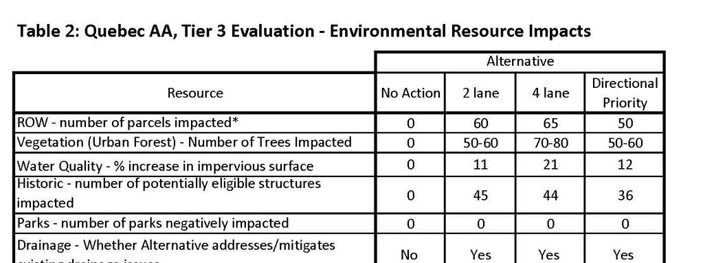
3 support in comparing the environmental impacts to key resources of these three alternatives. Methods: AECOM supplied Pinyon with graphical representations of each alternative and physical impact information for key environmental resources. It should be noted that the design is very preliminary at this stage and impact information and data are expected to change as design is refined. Identification of key resources was based on input gathered from stakeholder outreach efforts, high-level evaluations of resources which may be present and/or likely to be impacted, and whether the potential impacts associated with the three alternatives would differentiate the options from one another. These resources, along with general notes and high-level discussion of possible effects (positive and negative) that the project could have on each resource can be found in Table 1 at the end of the document. Results: Since this evaluation was generally based on negative impacts to environmental resources, the results indicate that the environmental effects for the three alternatives are generally moderately undesirable. This is expected as all options have impacts to the surrounding land uses and environmental resources. The evaluation shows that larger footprints, which have great ROW impacts, are associated with greater environmental impacts. In terms of improving mobility and operations, the opposite is true; alternatives with a larger footprint provide more capacity and greater improvement to level of service (LOS). The improved mobility and multi-modal connectivity also benefits the larger transportation network. The 4-Lane configuration includes the largest physical footprint for improvements outside of existing pavement due to the addition of travel lanes along Quebec Street. Correspondingly, it has the greatest amount of impact to the surrounding land uses and environmental resources. The 2-Lane configuration has less environmental impact than the 4-Lane alternative because it includes fewer improvements outside of existing pavement resulting in less impact. The Directional Priority alternative requires fewer anticipated acquisitions along Quebec Street, but has greater impact (due to upgrading of sidewalks) along Syracuse Street. Below is a discussion, by resource, of the anticipated environmental impacts. It compares the level of impact amongst the three alternatives under evaluation. The text also provides a recommendation as to the next step of analyses for each resource. It is important to note the distinction between acquisition and impact. The City and County of Denver right-of-way boundary extends into the frontages (front lawns) of a number of property owners. Thus, although the property may be impacted, it would not
4 necessarily need to be acquired (in full or part) since the property is within City and County of Denver ROW. Transportation Mobility The alternatives vary according to improvements in transportation mobility, as measured by Level of Service (LOS), longevity of congestion mitigation (in years), and travel time improvement (in minutes). Accommodations for multi-modal travel (bicycle, pedestrian and transit) would not vary by alternative. The findings below indicate that the 4-Lane Reconfigure Quebec would result in the highest level of service and longevity, as well as the greatest reduction in travel time. Level of Service Under existing conditions, six of the ten intersections in the study area are functioning below the minimum LOS C specified in the evaluation criteria. Level of service would continue to drop in the No Action alternative. Both Reconfigure Quebec options would improve all intersections to LOS C or better, with four of the ten intersections achieving a higher level of service in the 4-lane option than in the 2-lane option. The Directional Priority option fails to achieve the minimum LOS C at all intersections, with two intersections remaining at LOS D or E and an additional four intersections only barely achieving LOS C. Longevity of Congestion Mitigation Reconfigure Quebec would provide 17 years of mitigation under the 2-lane option, and 26 years of mitigation under the 4-lane configuration. Due to continued poor performance of a number of intersections under the Directional Priority option, this configuration would provide an aggregate congestion mitigation of only one year. Travel Time Improvement Under existing afternoon rush hour conditions, a northbound motorist can expect an average 8.8-minute travel time between 6th and 26 th Avenues. Under the No Action alternative, this time would continue to decline as volume increases, reaching an estimated 13.3 minutes by 2022 for travel along the same segment. In contrast, the 2- Lane reconfiguration would reduce this travel time to 6.8 minutes and 5.5 minutes with the 4-Lane reconfiguration. Due to the nature of Directional Priority which has more southbound than northbound lanes and capacity, travel time would improve to approximately 6.2 minutes southbound, but worsens to 10.2 minutes northbound. Multi-Modal Accommodations All of the build alternatives would provide similar pedestrian, cyclist and transit improvements. Both Reconfigure Quebec configurations as well as Directional Priority would provide continuous sidewalk along the length of the project on Quebec and
5 Syracuse, on-street bicycle facilities on Syracuse, and improved transit stops on Quebec. Socioeconomic Resources The quantitative indicators used to assess potential socioeconomic resource impacts that could result from implementation of the three alternatives included the number of parcels affected by ROW acquisition and the decrease in the distance between the curb to the façade of the building. Right-of-way acquisitions and a decrease of distance from the curb to building would not occur along Syracuse Street for any alternative, but would need to occur on Quebec Street under any of the options. Right-of-way acquisitions and reductions in the distance between the curb and the façade of the building would occur due to widening of Quebec Street including widening at intersections to accommodate travel lanes, turn lanes, bicycle lanes, and improved bus stop areas. Decreases in the distance between buildings and the street could reduce the value of the property, and could discourage potential buyers from considering the property. Properties with a shorter distance between the building and traffic could be less desirable as domiciles due a perceived increase in noise and danger from traffic. In addition, acquisition of ROW from residences, businesses, and community amenities would decrease the size and availability of properties and could reduce values of the affected and surrounding properties. The 4-Lane alternative, which has the largest footprint, also impacts the greatest number of properties: 65 parcels on Quebec Street. The 2-Lane alternative impacts 60 parcels adjacent to Quebec Street. Directional Priority would impact 50 parcels along Quebec. Under the Directional Priority, any impacts along Syracuse Street would be limited to installation of sidewalk, not a widening of the roadway itself. Of the three alternatives, the 4-Lane alternative would have the highest impact on the socioeconomic resources based on decreased distance from building to curb. It is important to note that these numbers are approximate based on a very preliminary level of design. In the next phase of study, impacts should be updated based on design refinement. Temporary impacts due to construction easements should be distinguished from permanent impacts. Additional types of impacts that could affect socio-economics such as change in parking and the benefits associated with improved mobility should be included in the assessment as well as changes in property tax revenues that may result from conversion of private property to a public transportation use should full acquisition by required based on reduction of curb to building.
6 Environmental Justice Populations Environmental justice populations are those that have a higher percentage of lowincome and/or minority residents than the City and County of Denver on average. Environmental justice (EJ) populations are present along both Quebec Street and Syracuse Street, on both sides to the street. Due to the dispersed nature of the EJ population throughout both corridors, impacts to households that are minorities and/or low-income are anticipated under any alternative, and would not be considered disproportionate. These households would also benefit from the improved mobility, which includes vehicular, transit, pedestrian, and bicycle modes of travel. The 4-Lane alternative is the least desirable since it could have a greater ROW impact. The 2-Lane alternative has the second largest number parcels that would experience a reduction in curb to building distance. The Directional Priority would have the least amount of impact with relation to EJ households. As a part of the next study, more specific data on the property owners and residents should be gathered. The potential for disproportionally high and adverse effects from the project and the No-Action Alternative to environmental justice populations in the Study Area should be determined. A disproportionally high and adverse effect occurs when: the EJ population bears predominately borne by a minority population and/or a low-income population; or suffered by the minority population and/or low-income population in an appreciably more severe or greater magnitude than the adverse effect that would be suffered by the non-minority population and/or non-low-income population When making this determination, mitigation enhancement measures and potential offsetting benefits to affected minority and/or low-income populations should be considered. Outreach to households along the corridor was made as part of this study; this should continue as part of future studies. Land Use Transportation improvements proposed as part of any alternative would alleviate congestion, improve mobility and provide a greater ability to access destinations along the corridor (as well as east Denver) more efficiently. Improvements are consistent with existing and future land use, zoning and transportation plans. The 4-Lane alternative provides the most capacity and could accommodate a larger amount of growth in travel demand.
7 The quantitative indicator used to assess potential land use impacts related to the three alternatives was a decrease in frontage that would result in a curb to building distance of 28 feet or less. Much of the area along Quebec Street has a minimum 28-foot setback requirement for residential areas. If the decrease of the curb to building distance results in some parcels not meeting the minimum setback, the land use for that parcel may need to change. The number of parcels with a setback of 28 feet or smaller varies between the three alternatives. The 4-Lane alternative has the greatest number of parcels that would no longer have the minimal required setback, followed by the 2-Lane and then Directional Priority. Through design refinement in the next study, opportunities to further avoid and minimize impacts to the surrounding parcels should be made. Should land use or zoning change, compatibility of the proposed improvements should be re-evaluated. If full parcels need to be acquired, any redevelopment needs to be consistent with land use and zoning plans and policies. Historic Resources including Section 4(f) Properties One property, the Paddington School at 1301 Quebec Street, is listed on the National Register of Historic Places (NRHP) 1. Other than replacing sidewalks and curbs, which may necessitate the removal of some trees and which would occur under any alternative, there are no ROW impacts anticipated for the Paddington School parcel. There are dozens of potential historic properties that have not been formally assessed for eligibility; these were identified through assessor s data as having been built over 50 years ago. Many of these parcels may lack the criteria needed to qualify for eligibility to the NRHP, and need more detailed analysis in the next phase. From a conservative point of view, if one were to calculate all properties 50 years old or older, the 2-Lane alternative could impact approximately 45 potentially eligible parcels, the 4-Lane could impact 44, and the Directional Priority could impact 36 (along Quebec). A high priority next step is to complete an eligibility assessment and effects determination for the parcels of interest. Historic resources are protected under Section 106 of the National Historic Preservation Act and also Section 4(f) of the 1960 Department of Transportation Act. Section 4(f) only permits conversion of a historic property to a transportation use if there is no other feasible and prudent alternative. Given the high number of potentially historic properties, it is important to identify which parcels are actually eligible for listing on the National Register of Historic Places and incorporate measures to avoid and minimize impacts into the design of alternatives. There is the possibility that an individual Section 4(f) would need to be completed 1 Note that the listing on the NRHP states the name of the school as the Stanley School; however, the Stanley School is located at 350 Quebec Street, which is south of the project area
8 should a finding of adverse effect be made for any of the anticipated impacts; this process can take a year or more to complete making it an immediate action item for the next study. Parklands/Recreational Section 4(f) Properties There are two parks adjacent to Quebec Street, Denison Park and Fred Thomas Park. The indicator used to assess effects is the amount and type of physical impact to these properties. Denison Park is located on the west side of Quebec Street between 11th Avenue and 12th Avenue. It has a basketball court, playground, picnic facilities, and a horseshoe pit. Fred Thomas Park is on the east side of Quebec Street between 23rd Avenue and 26th Avenue. This large park has several playing fields and picnic facilities as well as a bike/pedestrian path that provides connectivity to Greenway Park. Fred Thomas Park is also adjacent to Syracuse Street on the west side and the Greenway Park, to which it connects, is on the east side of Syracuse. McNichol s (William H) Park encompasses a full block between 17th Avenue and 18th Avenue immediate to the west of Syracuse Street. This park has several playing fields, a picnic area, and a pedestrian/bicycle path. The only impact would be due to the replacement of sidewalks and curbs. Access to both parks would be enhanced through upgrading of the sidewalks and bicycle facilities; this impact would occur under any alternative. In subsequent studies, the design should be refined to continue to avoid ROW impacts to the parks except for enhancements such as sidewalk improvements and curb installation. Public parks are protected under Section 4(f) of the 1960 Department of Transportation Act which applies to federal transportation agencies or any agency that utilizes funds from a federal transportation agencies. Any impact, including those that consider beneficial enhancements, need to be assessed to determine if an individual Section 4(f) analysis must be completed, or if the work falls under a programmatic category, or if it is a de minimis impact. Since funds from CDOT have been secured for the proposed improvements, an initial step will be to identify the magnitude and nature of any impact to the parks and consult with the agency as to the level of study and documentation required. Air Quality The quantitative indicator used to assess potential air impacts from the three alternatives includes the decrease in the distance between the curb to the façade of the building and improved LOS. The decrease in curb to façade distance might result in the perception that traffic moving closer to residences and businesses reduces air quality. In terms of air quality and the curb to building indicator, the 2-Lane alternative is the most desirable, and the 4-Lane is the least desirable alternative. However, the 4-Lane alternative would provide the highest level of mobility and most reduction in congestion; less congestion and reduced idling could actually improve air quality on a
9 very localized level as LOS improves. Should improved pedestrian and bicycle facilities and enhanced access to transit promote a reduction in vehicular travel, air quality would benefit. Since the project is located in an attainment/maintenance area for carbon monoxide, two analyses will be required to make a conformity determination. As the first step in a conformity determination, the agency or their representative will consult with the Air Pollution Control Division of the Colorado Department of Public Health and Environment to determine which roadways and signalized intersections will require a LOS analysis. This typically includes the signalized intersections that will be constructed, reconstructed, or modified as part of the project. Additionally, if the project could result in increased traffic at nearby intersections, those intersections may also need to be evaluated. A LOS analysis is completed for each intersection in the project area based on all project alternatives under evaluation, including the No-Action Alternative. The LOS analysis assesses each intersection based on the average wait time per vehicle and assigns a letter grade to each intersection for the morning (AM) and evening (PM) peak hour periods. An additional analysis, Hot Spot Modeling, is required for intersections forecasted to have a LOS of D or worse after project implementation. Hot spot modeling is a method of calculating the carbon monoxide concentrations along roadways and near intersections. The purpose of hot spot modeling is to evaluate whether a project coaswuld cause, or contribute to, a violation of the carbon monoxide National Ambient Air Quality Standards (NAAQS). Traffic Noise The quantitative indicator used to assess noise impacts from the three alternatives includes a decrease that would result in a curb to building distance of 28 feet or less. Much of the area along Quebec Street has a minimum setback requirement for residential areas based on various factors including noise considerations. A decrease of the curb to building distance could result in moving the primary source of noise (traffic) closer to the building on that parcel. In terms of noise and the curb to building indicator, the 2-Lane alternative is the most desirable and the 4-Lane is the least desirable alternative. The next step will to complete a full traffic noise assessment in accordance with the most-current CDOT Noise Analysis and Abatement Guidelines. The analysis can be customized based on the scope of improvements, site-specific location of improvements, and noise-sensitive receptors present. Mitigation measures for the impacted receptors will be considered. This is an important consideration based on the extensive number of noise receptors located within the study area that may be impacted. For mitigation to be considered, a feasibility and reasonableness evaluation must be performed. Feasibility relates to the ability to construct the mitigation measure and have it provide a reduction in noise levels. Reasonableness includes assessment of
10 mitigation benefits and costs. The third consideration is the desire of the property owners to have the mitigation, should it be found feasible and reasonable constructed, at least 50% of the affected property owners must support the installation of the mitigation. Given the context of the properties adjacent to Quebec Street it is unlikely that a noise wall would be found reasonable as it would need to have few, if any, breaks in it to reduce the noise levels and there are numerous direct access points off Quebec Street. Additionally, property owners may not want a wall blocking their access to the sidewalk, bicycle facility, and transit stops. Vegetation Resources Existing trees will likely need to be removed to accommodate the widening of Quebec. Reconfigure Quebec 2-Lane and Directional Priority would impact 50 to 60 mature trees, respectively. The more extensive roadway changes required in Reconfigure Quebec 4 Lane would impact 70 to 80 mature trees. As the process moves into final design, these impacts should be updated. Water Quality Resources Water quality was assessed in terms of the area that would be served by an improved drainage system. Stormwater Best Management Practices (BMPs) would be installed along Quebec Street as part of any alternative, but would only be installed along Syracuse Street should the Directional Priority alternative be implemented. Additional impervious surfaces could reduce water quality because they could allow for more concentrated water flows with pollutants from vehicles. Implementation of BMPs would address these issues. The 2-Lane and Directional Priority alternatives would result in an approximately 11 and 12% increase, respectively, while the 4-Lane alternative would add approximately 21% more impervious surface area than existing conditions. Water quality BMPs should be incorporated into the final design of the proposed alternative. This project is within both the City s and CDOT s Municipal Separate Storm Sewer (MS4) permit area. Should the next phase of study be an Environmental Assessment, the project will qualify as a priority project under CDOT definitions and will require design and implementation of on-site water quality mitigation. If the project is completed as a Categorical Exclusion, the amount of impervious surface and area of disturbance should be recalculated based on final design to determine whether it is a priority project. If it is not a priority project, the City s requirements for water quality will be followed. Hazardous Materials A total of 63 facilities were identified in the agency database report which documents regulated facilities within one quarter mile of both Quebec Street and Syracuse Street.
11 Those facilities noted in the database report may have the potential to contaminate soil and/or groundwater, which could impact the implementation of any alternative. For the purpose of the hazardous materials assessment, facilities identified in the agency database were categorized as either having a low or high potential to impact the study area, which is dependent on different factors, including: the distance between a potential source of a regulated material and the project; status of regulated facilities (e.g., active or inactive); known or suspected releases into soil, surface water or groundwater; and the hydrogeologic relationship of the source of a regulated material to the project. There are a total of eight facilities (with 40 listings) that have a high potential to impact construction along Syracuse Street. There are a total of six facilities (with 17 listings) that have a high potential to impact construction along Quebec Street. Most of these facilitates are located at the intersections with Colfax Avenue; this area has been historically developed with commercial facilities (i.e., gasoline stations, automotive repair facilities, dry cleaners). A known trichloroethylene (TCE) groundwater plume extends in a north/northwest direction from Lowry, and crosses Syracuse Street in the vicinity of East 22nd Street. Remediation activities have reduced TCE concentrations to levels acceptable to the state; however, there is still a potential for the project to encounter TCE-impacted groundwater in the vicinity of the plume. The depth to groundwater for the plume ranges from approximately 10 to 24 feet below the current grade in the area. In addition, two landfills are in the vicinity of Quebec Street, including one between 11th and 12th Avenues, and a second between 21st and 22nd Avenues. Environmental contaminants may be encountered during ground-disturbing activities at or near the hazardous materials facilities located within the study area. The most fundamental management for hazardous materials is to avoid activities within contaminated sites, which often is not feasible. After refinement of the alternative(s), a Modified Phase I Environmental Site Assessment or CDOT Initial Site Assessment should be conducted at site-specific locations to further evaluate hazardous materials. Right of Way The total number of parcels adjacent to Quebec Street and Syracuse Street that would have property acquired from them was the measure used to assess ROW impacts. The 2-Lane and 4-Lane alternatives could require acquisition of ROW of approximately 60 and 65 parcels, respectively, along Quebec. The Directional Priority alternative could impact a total of 50 parcels. Any impacts along Syracuse Street under the Directional Priority would occur due to construction of a continuous, ADA-compliant sidewalk and are not anticipated to result in permanent ROW acquisition. As design progresses, opportunities to avoid or further minimize ROW impacts should be made.
12 Conclusion Most of the impacts evaluated are related to the physical disturbance that could result from implementation of each of the alternatives. As a result, both the 4-Lane and 2- Lane configurations have the highest impact to the key environmental resources which were analyzed and pose the same level of risk for implementation (Table 2). However, improvements to mobility, multi-modal connectivity, and the overall transportation network may off-set these impacts. The next step, anticipated to be a study under the National Environmental Policy Act, will need to examine all resources present for potential impacts based on more detailed design. Opportunities for mitigation and cumulative impacts will also need to be considered in identifying a Preferred Action.
13 Table 1: Environmental Resources Description and Potential Effects Resource General Notes Positive Potential Effects Negative Transportation Network Purpose of this mobility plan is to improve the transportation network. Increased mobility, safety, and multi-modal options. Temporary impacts due to construction. Socioeconomics Socioeconomic conditions within the study area are extremely variable, with existing populations in established neighborhoods and new neighborhoods continuing to be developed in Stapleton and Lowry. Improved access and mobility and improved vehicular, pedestrian, and bicycle facilities. Acquisition of community facilities/amenities. Environmental Justice Federal agencies are mandated to consider Environmental Justice in decision-making, including minimizing impacts to minority and low-income populations. Increased mobility would likely have positive effects on minority and low-income populations with increased access to public transportation and improved vehicular, pedestrian, and bicycle facilities. Acquisition of right of way from residences, business, community amenities. Land Use Current land use and zoning in the project area is mixed; with population density increasing in the Stapleton and Lowry developments. Likely to enhance local land uses in the project area through implementation of the 2008 Strategic Transportation Plan and would accommodate growth in travel demand. Reduction of curb to building setback would impact existing property owners along the Quebec Street corridor. Historic Preservation Much of the existing development within the study area was constructed over 50 years ago. Properties that may be disturbed by implementation of improvements will need to be evaluated for eligibility for the National Register of Historic Places. Positive effects to this resource not anticipated. Impact to resources that are potentially eligible for the NRHP. Parklands and Recreation (Section 4(f) and 6(f)) Section 4(f) of the US Department of Transportation Act of 1960 provides protection for publicly owned parks, recreational areas, or wildlife and/or wildlife refuges and historical/archaeological sites. Connectivity to resources through provision of a consistent, ADA-compliant sidewalk is a public benefit; thus, a positive effect. There would only be positive impacts to these resources from the alternatives.
14 Air Quality The study area is located within an attainment/ maintenance area for carbon monoxide and particulate matter. Carbon monoxide hot spot modeling may be required for implementation of improvements. Possible positive effects due to: Lower congestion, less idling, improved traffic movements Improved level of service Improved intersection efficiency and increased bicycle/pedestrian/public transit use Public perception and potential actual decreased air quality due to closer proximity of the roadway to residences Traffic Noise Likely noise receptors located in the project area. Noise analysis may be required during design phase for specific projects. Noise levels would be modeled for existing and future conditions; should noise levels exceed CDOT NAC, mitigation options will be assessed to determine if they are reasonable, feasible, and desirable from the affected property owners. Alignments moved closer to residences may increase noise levels for those receptors. Free flow moving traffic would increase noise levels. Vegetation Vegetation along existing corridors likely includes disturbed urbanplant communities, noxious weeds, and decorative landscaping. There may be opportunities for re-vegetation in the corridor. Wider road cross section may lead to vegetation impacts/disturbance including loss of trees. Water Quality Water quality could be impacted by increased storm water runoff from development. Improvements to water quality through implementation of BMPs and applied engineering. All alternatives would increase impervious surface and may be required to treat surface run-off. Hazardous Materials Project is located in urban and developed area with various commercial and industrial uses that may have contributed to soil and/or groundwater contamination. Ground disturbance may encounter hazardous materials/waste necessitating remediation and resulting in clean-up of contamination. Potential cost increases to address contaminated media. Liability through acquisition of potentially contaminated properties. Right of Way Current transportation ROW is inconsistent and may not be adequate to accommodate alternatives. No likely positive effects to this resource. Acquisitions and relocations or residences and businesses. Existing ROW mapping indicates that, in certain areas, the transportation ROW is occupied by private uses; property owners may not be aware of ROW boundaries. Additional costs may be incurred by the project for acquiring ROW.
15
5.0 PRELIMINARY ENVIRONMENTAL REVIEW
 5.0 PRELIMINARY ENVIRONMENTAL REVIEW 5.1 INTRODUCTION A preliminary environmental review was performed on the proposed freeway improvements that form Concept C, which encompasses the three freeway corridors
INFORMATION REQUIRED FOR PROBABLE CATEGORICAL EXCLUSION (SECTION (d))
)") Grant Applicant: Proposed Project: Date: August 03, 2010 Northern Virginia Transportation Commission, Arlington County Government, and Washington Metropolitan Area Transit Authority Crystal City/Potomac
Grant Applicant: Proposed Project: Date: August 03, 2010 Northern Virginia Transportation Commission, Arlington County Government, and Washington Metropolitan Area Transit Authority Crystal City/Potomac
Site Criteria Evaluation Matrix
 FILED FOR RECORD 2/16/2016 9:00 AM Dana Debeauvoir - County Clerk, Travis County,TX Item 12 - ADDITIONAL Site Criteria Evaluation Matrix Belinda Powell, Travis County, ED&SI Matias Segura and Jerimi Henry,
Evaluation of Alternatives
 Chapter 9.0 Evaluation of Alternatives Chapter 9.0 provides a summary evaluation of the No Build Alternative and the Preferred Alternative. The evaluation contained within this chapter is an assessment
TRANSPORTATION RELATIONSHIP TO OTHER ELEMENTS OF THE PLAN AND COUNTY REGULATIONS VISION FOR TRANSPORTATION PLANNING ROAD NETWORK SECTION 7
 TRANSPORTATION Like many growing western counties, Douglas County focuses on one of the most integral elements in land-use planning: transportation. The primary purpose of a transportation network is to
MEMORANDUM. Date: July 14, 2006 Project #: To: US 97 & US 20 Refinement Plan Steering Committee
 MEMORANDUM Date: July 14, 2006 Project #: 6389 To: US 97 & US 20 Refinement Plan Steering Committee From: Sonia Hennum, P.E., Andrew Cibor, E.I.T., & Julia Kuhn, P.E. Project: US 97 & US 20 Refinement
Section 7 Environmental Constraints
 Section 7 Environmental Constraints i Yakima Valley Metropolitan and Regional Transportation Plan Public Comment DRAFT 1/27/2016 Environmental Constraints Analysis A programmatic-level review of potential
Work Breakdown Structure Element Dictionary Preliminary Engineering
 Element Name Initiation PE 3.1 Initiation includes the implementation of the project s funding and notification of the consultant or in-house design staff to commence work, the Kickoff Meeting with the
Torbram Road Improvements From Queen Street East to Bovaird Drive
 Torbram Road Improvements From Queen Street East to Bovaird Drive Municipal Class EA Study Public Information Centre No. 1 November 16 2017 6:30 pm 8:30 pm Please sign in so we can keep you updated on
Wyandanch Intermodal Transit Facility
 Wyandanch Intermodal Transit Facility Environmental Assessment July 2010 Prepared by: The United States Department of Transportation Federal Transit Administration in cooperation with The Town of Babylon
Executive Summary. What is the I-70 East EIS project and where is it located?
 The Executive Summary of the Supplemental Draft Environmental Impact Statement (EIS) provides an overview of the project, including the project purpose and need, project description, evaluated alternatives,
Guidelines for the Submission of a Transportation Study Level 2
 Guidelines for the Submission of a Transportation Study Level 2 For Site Development Applications in the City of North Vancouver Transportation Group, City of North Vancouver Engineering, Parks & Environment
DRAFT AIR QUALITY TECHNICAL MEMORANDUM
 AIR QUALITY TECHNICAL MEMORANDUM PROJECT DEVELOPMENT AND ENVIRONMENT STUDY STATE ROAD 60 GRADE SEPARATION OVER CSX RAILROAD Polk County, Florida Financial Project ID: 436559-1-22-01 Prepared for: Florida
FEDERAL BOULEVARD (5 TH AVENUE TO HOWARD PLACE) PLANNING ENVIRONMENTAL LINKAGE STUDY TRAFFIC NOISE IMPACT ANALYSIS
 PLANNING ENVIRONMENTAL LINKAGE STUDY TRAFFIC NOISE IMPACT ANALYSIS") FEDERAL BOULEVARD (5 TH AVENUE TO HOWARD PLACE) PLANNING ENVIRONMENTAL LINKAGE STUDY TRAFFIC NOISE IMPACT ANALYSIS Prepared for: City and County of Denver 201 West Colfax Avenue, Department 509 Denver,
FEDERAL BOULEVARD (5 TH AVENUE TO HOWARD PLACE) PLANNING ENVIRONMENTAL LINKAGE STUDY TRAFFIC NOISE IMPACT ANALYSIS Prepared for: City and County of Denver 201 West Colfax Avenue, Department 509 Denver,
11 Joint Development Regulatory Context and Methodology
 11 Joint Development This chapter describes the long-term direct and potential indirect impacts, and short-term direct and potential indirect impacts, of the proposed METRO Blue Line Light Rail Transit
WELCOME IL 47. Community Advisory Group Meeting #5 Waubonsee Community College Wednesday, May 31, 2017
 WELCOME IL 47 Community Advisory Group Meeting #5 Waubonsee Community College Wednesday, May 31, 2017 MEETING PURPOSE MEETING AGENDA 1. Welcome/Introduction 2. Review Previous Public Involvement 3. Process/Schedule
Welcome and thank you for spending time with us today to talk about the 75 th Street Corridor Improvement Project.
 1 Welcome and thank you for spending time with us today to talk about the 75 th Street Corridor Improvement Project. 2 During this public meeting, we will explain the 75 th Street Corridor Improvement
Transportation and Utilities
 4 Section 4 Transportation and Utilities 4.0 Introduction Transportation and utility systems are essential to accommodate and support development proposed in the Future Land Use Map. The following pages
Lynnwood Link Extension 2013 Draft EIS Comments and Responses
 Page 157 C-001-001 Sound Transit acknowledges your opposition to Alternative C1 due to its residential impacts and impacts to Scriber Creek Park and wetlands. Page 158 C-002-001 Following the Draft EIS,
BENNING ROAD & BRIDGES
 BENNING ROAD & BRIDGES DRAFT JUNE 2015 TRANSPORTATION IMPROVEMENTS ENVIRONMENTAL ASSESSMENT DRAFT MAY 2016 EXECUTIVE SUMMARY ES-1 This page left intentionally blank This page left intentionally blank
Lynnwood Link Extension 2013 Draft EIS Comments and Responses. Page 945
 I-441-001 Thank you for your comments about the importance of the Latvian Center to the Latvian community. Following the Draft EIS, the Sound Transit Board directed Sound Transit to develop a Preferred
Corridor Planning Standards + Potential Performance Measures
 Corridor Planning Standards + Potential Performance Measures January 17, 2007 1. Transportation improvements should connect people with potential places of employment and regional activity centers, particularly
Interstate 66 Tier 1 Environmental Impact Statement Public Hearing
 Interstate 66 Tier 1 Environmental Impact Statement Public Hearing 1 Project Corridor Study Process / Tiering Approach Tier 1 EIS focuses on broad issues - Purpose and need - Mode / Technology choice -
LONG ISLAND RAIL ROAD EXPANSION PROJECT FROM FLORAL PARK TO HICKSVILLE DRAFT ENVIRONMENTAL IMPACT STATEMENT
 LONG ISLAND RAIL ROAD EXPANSION PROJECT FROM FLORAL PARK TO HICKSVILLE DRAFT ENVIRONMENTAL IMPACT STATEMENT Project Name: Project Location: Lead Agency & Contact Person: SEQRA Classification: Project Sponsors:
Environmental Setting
 Section 5.2 Environmental Justice This section describes the potential of the proposed changes to the approved project to result in disproportionately high and adverse health or environmental effects on
St. Francis Drive through the City of Santa Fe Corridor Study
 VIII. ENGINEERING AND ENVIRONMENTAL EVALUATION INTERSECTION IMPROVEMENTS SOUTHERN For the southern end of the corridor, traffic volumes are expected to increase over existing levels. The Phase A Report
OPTIONAL STATIONAVIATION/MANCHESTER
 CRENSHAW/LAX TRANSIT CORRIDOR PROJECT FEIS/FEIR OPTIONAL STATIONAVIATION/MANCHESTER Aviation and Manchester, Looking East Aviation/Manchester Station (Optional) The Optional Aviation/Manchester Station
Taylorsville-Murray Transit
 Taylorsville-Murray Transit Environmental Study Report April 2013 Prepared for Table of Contents Acronyms & Abbreviations... iv Executive Summary... ES 1 Chapter 1: Purpose and Need 1.1 Project Description...
ES.1 What is the I-70 East EIS project and where is it located?
 EXECUTIVE SUMMARY The Executive Summary of the Final Environmental Impact Statement (EIS) provides an overview of the project, including the project purpose and need, project description, evaluated alternatives,
Final Air Quality Report
 Florida Department of TRANSPORTATION Final Air Quality Report PD&E Study From East of Babcock Street (SR 507) to US 1 Brevard County, Florida Financial Project ID: 430136-1-22-01 ETDM Project Number: 13026
Welcome. Public Meeting. August 2, :00 to 7:00 p.m. Presentation 6:00 to 6:30 p.m.
 Welcome Public Meeting August 2, 2017 5:00 to 7:00 p.m. Presentation 6:00 to 6:30 p.m. www.glenwoodsouthbridge.net Welcome to the South Bridge Environmental Assessment Public Meeting Why Are We Here Tonight?
Environmental Analysis, Chapter 4 Consequences, and Mitigation
 Environmental Analysis, Chapter 4 Table 4.17-3. Summary of Adverse Environmental Justice Impacts Topic No Build TSM At-Grade Emphasis LRT Underground Emphasis LRT Locally Preferred Alternative Transit
I-70 East ROD 1: Phase 1 (Central 70 Project) Air Quality Conformity Technical Report
 Air Quality Conformity Technical Report") I-70 East ROD 1: Air Quality Conformity Technical Report January 2017 I-70 East ROD 1: Air Quality Conformity Technical Report TABLE OF CONTENTS Chapter Page 1 PURPOSE OF THIS REPORT... 1 2 PROJECT DESCRIPTION...
I-70 East ROD 1: Air Quality Conformity Technical Report January 2017 I-70 East ROD 1: Air Quality Conformity Technical Report TABLE OF CONTENTS Chapter Page 1 PURPOSE OF THIS REPORT... 1 2 PROJECT DESCRIPTION...
APPENDIX A - PLANS AND POLICY REVIEW FEBRUARY 2017
 APPENDIX A - PLANS AND POLICY REVIEW FEBRUARY 2017 DENVERMOVES Transit Denver Moves: Transit APPENDIX A PLANS AND POLICY REVIEW 2035 Metro Vision Regional Transportation Plan (MVRTP) (2011) 2040 Fiscally
PERMITTED USES: Within the MX Mixed Use District the following uses are permitted:
 6.24 - MX - MIXED USE DISTRICT 6.24.1 INTENT: The purpose of the MX Mixed Use District is to accommodate the development of a wide-range of residential and compatible non-residential uses (including major
City of Los Angeles 2010 Bicycle Plan First Year of the First Five-Year Implementation Strategy & Figueroa Streetscape Project Draft EIR
 5.0 ALTERNATIVES California Environmental Quality Act (CEQA) requires that an EIR describe a range of reasonable alternatives to the project or to the location of the project that could feasibly avoid
Categorical Exclusion (CE)
") Categorical Exclusion (CE) Project Information Project Name: Federal Project#: Project Number: 0029-002-135, D624, P101 Project Type: Construction UPC: 77383 Charge Number: Route Number: 29 Route Type:
Categorical Exclusion (CE) Project Information Project Name: Federal Project#: Project Number: 0029-002-135, D624, P101 Project Type: Construction UPC: 77383 Charge Number: Route Number: 29 Route Type:
Appendix C - Highway 400 Widening and Interchange Evaluation Summary Tables
 Highway 400 Improvements from 1 km South of Highway 89 to the Junction of Highway 11 Appendix C - Highway 400 Widening and Interchange Tables Prepared for: Ontario Ministry of Transportation Four General
3.11 HAZARDOUS MATERIALS
 3.11 HAZARDOUS MATERIALS 3.11.1 Introduction to Analysis This section provides information regarding known contaminated sites and general areas of potentially contaminated properties along the proposed
65 East Project (P18-045) Addendum to an Environmental Impact Report
 Addendum to an Environmental Impact Report") 65 East Project (P18-045) Addendum to an Environmental Impact Report File Number/Project Name: 65 East Project (P18-045) Project Location and Surrounding Land Uses: The proposed project site consists of
65 East Project (P18-045) Addendum to an Environmental Impact Report File Number/Project Name: 65 East Project (P18-045) Project Location and Surrounding Land Uses: The proposed project site consists of
Hamilton Green. Draft Environmental Impact Statement (DEIS)
") Hamilton Green Draft Environmental Impact Statement (DEIS) June 2017 HAMILTON GREEN DRAFT ENVIRONMENTAL IMPACT STATEMENT (DEIS) June 14, 2017 Lead Agency: SEQRA Classification: City of White Plains Common
Hamilton Green Draft Environmental Impact Statement (DEIS) June 2017 HAMILTON GREEN DRAFT ENVIRONMENTAL IMPACT STATEMENT (DEIS) June 14, 2017 Lead Agency: SEQRA Classification: City of White Plains Common
APPENDIX B. Public Works and Development Engineering Services Division Guidelines for Traffic Impact Studies
 APPENDIX B Public Works and Development Engineering Services Division Guidelines for Traffic Impact Studies Revised December 7, 2010 via Resolution # 100991 Reformatted March 18, 2011 TABLE OF CONTENTS
Traffic Impact Analysis Guidelines. Town of Queen Creek
 Traffic Impact Analysis Guidelines Town of Queen Creek January 2016 1. INTRODUCTION The purpose of this document is to outline the procedures and requirements for preparing a Transportation Impact Analysis
Lynnwood Link Extension 2013 Draft EIS Comments and Responses. Page 216
 C-013-001 Thank you for your comments describing the cultural importance of the Latvian Evangelical Lutheran Church to the Latvian community in western Canada. See Section 2.5.1 for a description of the
MEMORANDUM #4. DATE: November 4, Warrenton TSP Project Management Team. Ray Delahanty, AICP, DKS Associates Kate Petak, EIT, DKS Associates
 MEMORANDUM #4 DATE: November 4, 2015 TO: FROM: SUBJECT: Warrenton TSP Project Management Team Ray Delahanty, AICP, DKS Associates Kate Petak, EIT, DKS Associates Warrenton Transportation System Plan Update
Chapter 5 Transportation Draft
 Chapter 5 Transportation Draft Discussion Similar to the other elements in the Comprehensive Plan, the transportation element impacts the quality of life, economic development and public safety of the
LUNDY S LANE COMMUNITY IMPROVEMENT PLAN STUDY
 PUBLIC INFORMATION MEETING # October, 0 LUNDY S LANE COMMUNITY IMPROVEMENT PLAN STUDY AGENDA :00 to :0pm: Open House :0 to :pm: Presentation : to :00pm: Individual paced workshop with the Study Team PUBLIC
ALBION FLATS DEVELOPMENT EXISTING TRAFFIC CONDITIONS AND POTENTIAL IMPACTS
 EXISTING TRAFFIC CONDITIONS AND POTENTIAL IMPACTS FINAL REPORT SEPTEMBER 2010 TABLE OF CONTENTS 1.0 INTRODUCTION 1 2.0 EXISTING TRAFFIC CONDITIONS 2 3.0 FUTURE TRAFFIC CONDITIONS 3 4.0 POTENTIAL IMPACTS
Table of Contents. Green Line Extension Project. Draft Environmental Impact Report/Environmental Assessment and Draft Section 4(f) Evaluation
 Evaluation") Table of Contents Acronyms and Abbreviations Secretary s Certificate on the EENF Executive Summary 1 Introduction and Background... 1-1 1.1 Introduction... 1-1 1.2 Project Summary... 1-2 1.3 Permits and
Table of Contents Acronyms and Abbreviations Secretary s Certificate on the EENF Executive Summary 1 Introduction and Background... 1-1 1.1 Introduction... 1-1 1.2 Project Summary... 1-2 1.3 Permits and
EVALUATION OF ALTERNATIVES CARRIED FORWARD
 1 EVALUATION OF ALTERNATIVES CARRIED FORWARD This chapter presents a comparative evaluation of the alternatives carried forward in this Final Environmental Impact Statement (EIS). The intent of this evaluation
Hazardous Materials Technical Memorandum
 Hazardous Materials Technical Memorandum Southeast Extension Project Lincoln Station to RidgeGate Parkway Prepared for: Federal Transit Administration Prepared by: Denver Regional Transportation District
State Route 8 Bridge Replacement Project
 OPEN HOUSE PUBLIC INVOLVEMENT MEETING Celebration Church 688 Dan Street, Akron, Ohio Tuesday, July 14, 2015 5:00 PM to 7:00 PM State Route 8 Bridge Replacement Project Existing Bridge Future Bridges: Steel
A. INTRODUCTION B. NOISE ANALYSIS METHODOLOGY
 Chapter 8: and Vibration A. INTRODUCTION This chapter assesses the potential noise impacts resulting from operation of the proposed Wyandanch Intermodal Transit Facility by comparing existing noise levels
STAFF REPORT. About percent depending on how much is added in the outdoor storage area (max allowed where storm sewer exists is 90 percent).
.") STAFF REPORT Application: Conditional use permit for the operation of a light repair (small engine repair) business with retail sales and outdoor storage in a fenced area. Applicant: Matthew L Rezac Property
STAFF REPORT Application: Conditional use permit for the operation of a light repair (small engine repair) business with retail sales and outdoor storage in a fenced area. Applicant: Matthew L Rezac Property
Traffic Impact Study Requirements
 [TYPE THE COMPANY NAME] Traffic Impact Study Requirements County of San Mateo Department of Public Works Roadway Services 9/1/2013 I. Introduction The County of San Mateo (County), Department of Public
SUBURBAN EDGE COMMUNITY ROLE COUNCIL ROLE ALL COMMUNITIES SUBURBAN EDGE
 Orderly and Efficient Land Use Align land use, development patterns, and infrastructure to make the best use of public and private investment. Plan and stage development for forecasted growth through 2040
MOSLEY STREET URBANIZATION TH
 Public Information Centre 1 (PIC 1) MOSLEY STREET URBANIZATION TH 45 BEACHWOOD ROAD TO STREET Class Environmental Assessment November 29, 2016 Welcome 2 This Public Information Centre will: establish channels
Chapter 5 - Transportation
 Chapter 5 - Transportation Discussion Similar to the other elements in the Comprehensive Plan, the transportation element impacts the quality of life, economic development and public safety of the residents
MEMORANDUM: INITIAL CONCEPTS SUMMARY
 MEMORANDUM: INITIAL CONCEPTS SUMMARY INTRODUCTION This memo presents a summary of initial concepts that have been identified as development of the project study has progressed, along with a recommendations
3.0 AFFECTED ENVIRONMENT, IMPACT EVALUATION, AND MITIGATION MEASURES
 TABLE OF CONTENTS Page 3.0 AFFECTED ENVIRONMENT, IMPACT EVALUATION, AND MITIGATION MEASURES ------------------------------------------------------------------------------------------------ 3-1 3.1 Land
Future Build Alternative Traffic Forecasts and Level of Service Analysis
 4.2.10 Future Build Alternative Traffic Forecasts and Level of Service Analysis For the five Build Alternatives, study intersections within one mile of potential station locations were analyzed, as it
BCEO TRAFFIC IMPACT STUDY GUIDELINES
 BCEO TRAFFIC IMPACT STUDY GUIDELINES February 2006 TABLE OF CONTENTS INTRODUCTION..... i TRAFFIC IMPACT STUDY STRUCTURE... 1 WHEN IS A TRAFFIC IMPACT STUDY NEEDED?..... 1 STUDY AREA, SITE PLAN & HORIZON
DIVISION I TRAFFIC IMPACT STUDY GUIDELINES ENGINEERING STANDARDS
 CITY OF ALBANY DEPARTMENT OF PUBLIC WORKS DIVISION I TRAFFIC IMPACT STUDY GUIDELINES ENGINEERING STANDARDS Prepared By PUBLIC WORKS DEPARTMENT ALBANY, OREGON 97321 Telephone: (541) 917-7676 TABLE OF CONTENTS
Standard Performance Attributes for Transportation Projects
 Standard s for Transportation Projects Mainline Operations Local Operations Maintainability Construction Impacts Environmental Impacts Project Schedule An assessment of traffic operations and safety on
Revenues and expenditures increase based on the tax district increase due to increases in real estate assessments in CY 2016 compared to CY 2015.
 CRYSTAL CITY, POTOMAC YARD, AND PENTAGON CITY TAX INCREMENT FINANCING AREA Our Mission: To provide a supplemental financial mechanism for the revitalization of Crystal City, Potomac Yard, and Pentagon
PLANNED UNIT DEVELOPMENT, PLANNING APPROVAL & SUBDIVISION STAFF REPORT Date: June 4, 2015
 PLANNED UNIT DEVELOPMENT, PLANNING APPROVAL & SUBDIVISION STAFF REPORT Date: June 4, 2015 NAME SUBDIVISION NAME CC Williams Plant Subdivision CC Williams Plant Subdivision LOCATION CITY COUNCIL DISTRICT
Reconstruction Project Update
 I-65/I-70 North Split Interchange Reconstruction Project Update September 18, 2017 Agenda Welcome/introductions Project overview Scope and limits Need Environmental Assessment Maintenance of traffic Financial
ENVIRONMENTAL ASSESSMENT Federal Boulevard Improvements Project Between West 7 th Avenue and West Howard Place
 ENVIRONMENTAL ASSESSMENT Federal Boulevard Improvements Project Between West 7 th Avenue and West Howard Place Project Number: NHPP 2873-172, Project Code: 19957 City and County of Denver, Colorado Lead
Memorandum. FROM: Jim Ortbal Rosalynn Hughey Barry Ng TO: HONORABLE MAYOR, CITY COUNCIL. DATE: June 16, 2017
 CITY OF SANjOSE CAPITAL OF SILICON VALLEY TO: HONORABLE MAYOR, CITY COUNCIL SUBJECT: TRANSPORTATION POLICY UPDATE REQUIRED BY STATE LAW - LOS TO VMT Memorandum FROM: Jim Ortbal Rosalynn Hughey Barry Ng
LONG ISLAND RAIL ROAD EXPANSION PROJECT FROM FLORAL PARK TO HICKSVILLE FINAL ENVIRONMENTAL IMPACT STATEMENT
 LONG ISLAND RAIL ROAD EXPANSION PROJECT FROM FLORAL PARK TO HICKSVILLE FINAL ENVIRONMENTAL IMPACT STATEMENT Project Name: Project Location: Lead Agency & Contact Person: SEQRA Classification: Project Sponsors:
12 Evaluation of Alternatives
 12 Evaluation of Alternatives This chapter evaluates the effectiveness of the No-Build Alternative and the proposed METRO Blue Line Light Rail Transit (BLRT) Extension project based on the information
NYU CORE Construction Presentation
 NYU CORE Construction Presentation Prepared for Community Board 2 January 18, 2012 1 Construction Impacts Chapter 20 of the DEIS Transportation o Traffic o Transit o Pedestrians o Parking Air Quality Noise
CRYSTAL CITY, POTOMAC YARD, AND PENTAGON CITY TAX INCREMENT FINANCING AREA
 CRYSTAL CITY, POTOMAC YARD, AND PENTAGON CITY TAX INCREMENT FINANCING AREA Our Mission: To provide a supplemental financial mechanism for the revitalization of Crystal City, Potomac Yard, and Pentagon
NYU CORE Construction Presentation
 NYU CORE Construction Presentation Prepared for Community Board 2 January 18, 2012 1 Construction Impacts Chapter 20 of the DEIS Transportation o Traffic o Transit o Pedestrians o Parking Air Quality Noise
Appendix G Analysis of Project Impacts Compared to Existing Conditions
 Appendix G Analysis of Project Impacts Compared to Existing Conditions This page intentionally left blank. Analysis of Project Impacts Compared to Existing Conditions Introduction The analysis scenarios
5.0 LONG-TERM CEQA CONSIDERATIONS
 5.0 LONG-TERM CEQA CONSIDERATIONS Section 15126 of the CEQA Guidelines requires that all phases of a project must be considered when evaluating its impact on the environment, including planning, acquisition,
1) ENERGY CONSERVATION
 ENERGY CONSERVATION") Sustainable development... "meets the needs of the present without compromising the ability of future generations to meet their own needs." - United Nations Brundtland Commission Report, 1987 During the
Sustainable development... "meets the needs of the present without compromising the ability of future generations to meet their own needs." - United Nations Brundtland Commission Report, 1987 During the
Section 3.11: Hazardous Materials
 Section 3.11: Hazardous Materials Section 3.11 Hazardous Materials 3.11 HAZARDOUS MATERIALS 3.11.1 Introduction to Analysis This section provides information regarding known contaminated sites and general
CHAPTER 13 R-5 MANUFACTURED MOBILE HOME PARK RESIDENTIAL DISTRICT
 15.1300 CHAPTER 13 R-5 MANUFACTURED MOBILE HOME PARK RESIDENTIAL DISTRICT 15.1301 SECTION 13.01 STATEMENT OF PURPOSE To provide for manufactured home park development, of long-term duration of stay, in
SECTION 5: ALTERNATIVES TO THE PROPOSED PROJECT
 SECTION 5: ALTERNATIVES TO THE PROPOSED PROJECT 5.1 - Introduction In accordance with CEQA Guidelines Section 15126.6, this Draft Subsequent Environmental Impact Report (DSEIR) contains a comparative impact
VDOT Land Use Overview. Brad Shelton, AICP Transportation and Mobility Planning Division June 2015
 VDOT Land Use Overview Brad Shelton, AICP Transportation and Mobility Planning Division June 2015 VDOT Land Development Programs Local/State Plan and Program Consistency Review local comp plan transportation
Lynnwood Link Extension 2013 Draft EIS Comments and Responses. Page 275
 C-034-001 Thank you for your comments describing the cultural importance of the Latvian Evangelical Lutheran Church. See Section 2.5.1 for a description of the refined Segment A alternatives that avoid
NEPA and Design Public Hearings
 NEPA and Design Public Hearings Monday, December 5, 2016 Washington-Lee High School 1301 N. Stafford Street Arlington, VA 22201 Thursday, December 8, 2016 Mary Ellen Henderson Middle School 7130 Leesburg
LOCATION HYDRAULIC REPORT
 Draft LOCATION HYDRAULIC REPORT Florida Department of Transportation District One US 41 at Fruitville Road (CR 780) Intersection Improvements - PD&E STUDY Sarasota County, Florida Financial Project ID
4 Project Alternatives
 CHAPTER 4 PROJECT ALTERNATIVES 4.1 Introduction This section summarizes The Villages Escondido Country Club Project (Project) to allow for an evaluation of its comparative merit with a range of reasonable
A three-stage process was implemented in order to develop and evaluate the project concepts and provide recommendations for the project.
 MEMORANDUM TO: FROM: Highway 36/Rice Street PMT Mark Benson DATE: March 23, 2009 RE: Selection of a Preferred Alternative SEH No. 105803 The purpose of this memorandum is to document the process for selecting
6 ALTERNATIVES 6.1 INTRODUCTION
 6 ALTERNATIVES 6.1 INTRODUCTION Section 15126.6 of the California Environmental Quality Act (CEQA) Guidelines states that an EIR is to describe a range of reasonable alternatives to the proposed project,
4: Transportation and Land Use
 Chapter Figure 4-1: Recent development has brought more housing and mixed use Downtown Minneapolis - looking north from E 15th Street at the Grant Street / 11th Street exit 4: Transportation and Land Use
Sidewalk Regulations. Table of Contents
 Sidewalk Regulations Table of Contents Section 1. Purpose and Intent... 2 Section 2. Pedestrian Sidewalk, Driveway Apron and Curb and Guttering Requirements... 2 Section 3. Sidewalk Provision Criteria...
Categorical Exclusion (CE)
") Categorical Exclusion (CE) Project Information Project Name: Widen E Elden St from Van Buren St to Fairfax County Parkway Federal Project#: HPT-5401( ) Project Number: U000-235-110, C501, P101, R201 Project
Categorical Exclusion (CE) Project Information Project Name: Widen E Elden St from Van Buren St to Fairfax County Parkway Federal Project#: HPT-5401( ) Project Number: U000-235-110, C501, P101, R201 Project
6/8/2016. Development Factors. Part 58 Review. Environmental Assessment Development Factors
 Development Factors Part 58 Review Environmental Assessment Development Factors 1 Environmental Assessment Development Factors Impact Codes Make a Determination of Impact for each factor by choosing the
RURAL CENTER COMMUNITY ROLE COUNCIL ROLE RURAL CENTER ALL COMMUNITIES
 Orderly and Efficient Land Use Align land use, development patterns, and infrastructure to make the best use of public and private investment. Plan for forecasted population and household growth at overall
Traffic Impact Study Guidelines. City of Guelph
 Traffic Impact Study Guidelines City of Guelph April 2016 Engineering and Capital Infrastructure Services Infrastructure, Development & Enterprise 1 Carden Street Guelph, Ontario Canada N1H 3A1 Page 1
Oklahoma Department of Transportation Environmental Programs Division Office Fax
 Oklahoma Department of Transportation Environmental Programs Division Office 521-3050 Fax 522-5193 Documented Categorical Exclusion (DCE) for I-40: Pavement Reconstruction and Added Lanes from the Douglas
Capital Facilities Element
 Capital Facilities Element Purpose The Growth Management Act requires cities to prepare a capital facilities element consisting of: 1. An inventory of current capital facilities owned by public entities,
KALIA-FORT DERUSSY WASTEWATER SYSTEM IMPROVEMENTS FINAL ENVIRONMENTAL ASSESSMENT EXECUTIVE SUMMARY
 EXECUTIVE SUMMARY This Environmental Assessment (EA) addresses the environmental impacts of the Proposed Action to construct certain improvements to the City and County of Honolulu (City) wastewater collection
Review Zone Application for D&R Canal Commission Decision
 Review Zone Application for D&R Canal Commission Decision MEETING DATE: January 18, 2017 DRCC #: 16-3020C Latest Submission Received: January 10, 2016 Applicant: PVP Franklin, LLC 769 Northfield Avenue,
SANTA BARBARA COUNTY ZONING ADMINISTRATOR STAFF REPORT October 21, 2011
 SANTA BARBARA COUNTY ZONING ADMINISTRATOR STAFF REPORT October 21, 2011 PROJECT: Gilson Move Dwelling HEARING DATE: November 7, 2011 STAFF/PHONE: J. Ritterbeck, (805) 568-3509 GENERAL INFORMATION Case
I-70 East PACT DRAFT EVALUATION DATA
 I-70 East PACT DRAFT EVALUATION DATA Future Current Alignment NEIGHORHOOD QUALITY: Maintain quality of life and protect community values. Improve or maintain neighborhood connectivity Assess neighborhood
Alternatives Identification and Evaluation
 I-290 Environmental Impact Statement West of Mannheim Road to East of Cicero Avenue Alternatives Identification and Evaluation May 2012 Draft Interim Report: Initial Alternatives Identification and Round