Draft Environmental Impact Statement
|
|
|
- Caroline Miles
- 5 years ago
- Views:
Transcription

1 Draft Environmental Impact Statement North Houston Highway Improvement Project, Houston District From US /I- at Spur to I- at Beltway North CSJ: Harris County, Texas April 0 TxDOT will issue a single Final Environmental Impact Statement and Record of Decision document pursuant to Pub. L. -, Stat. 0, Section (b) unless TxDOT determines statutory criteria or practicability considerations preclude issuance of the combined document pursuant to Section. The environmental review, consultation, and other actions required by applicable Federal environmental laws for this project are being, or have been, carried-out by TxDOT pursuant to U.S.C., and a Memorandum of Understanding dated December, 0 and executed by FHWA and TxDOT.
2 PAGE INTENTIONALLY LEFT BLANK
3 NORTH HOUSTON HIGHWAY IMPROVEMENT PROJECT FROM US /- AT SPUR TO - AT BELTWAY NORTH CSJ: HARRIS COUNTY, TEXAS DRAFT ENVIRONMENTAL IMPACT STATEMENT Submitted Pursuant to U.S.C. ()(c) and U.S.C. 0 by the Texas Department of Transportation Date of Approval Texas Department of Transportation April 0 The environmental review, consultation, and other actions required by applicable Federal environmental laws for this project are being, or have been, carried-out by Texas Department of Transportation (TxDOT) pursuant to U.S.C., and a Memorandum of Understanding dated December, 0 and executed by Federal Highway Administration (FHWA) and TxDOT. TxDOT will issue a single Final Environmental Impact Statement (EIS) and Record of Decision (ROD) document pursuant to Pub. L. -, Stat. 0, Section (b) unless TxDOT determines statutory criteria or practicability considerations preclude issuance of the combined document pursuant Section. Comments on the Draft EIS (due 0 days from the date the Notice of Availability is published in the Federal Register) should be sent to the Texas Department of Transportation, Attention: Director of Project Development, P.O. Box, Houston, Texas.
4 PAGE INTENTIONALLY LEFT BLANK
5 For additional information concerning the document, please contact: Mr. Carlos Swonke Director of Environmental Affairs Texas Department of Transportation Dewitt C. Greer State Highway Building East th Street Austin, Texas 0- Telephone: () - ABSTRACT: The proposed North Houston Highway Improvement Project (NHHIP) would include the addition of four managed express (MaX) lanes (including high-occupancy vehicle [HOV] and toll lanes) on Interstate Highway (I-) from Beltway North to Downtown Houston, including reconstruction of mainlanes and frontage roads, and the rerouting of I- in the Downtown area to be coincident with I-0 on the north side of Downtown and coincident with U.S. Highway (US) /I- on the east side of Downtown. The existing elevated I- roadway along the west and south sides of Downtown would be removed. Access to the west side of Downtown would be provided via Downtown Connectors, which would provide access to and from various Downtown streets. Both I-0 and US /I- within the proposed project area would be realigned to eliminate the current roadway curvature, and four elevated I-0 Express lanes would be added between I- and US /I-. The social, economic, and environmental impacts of the proposed NHHIP are evaluated for land use, soils and geology, social, economics, air quality, noise, wetlands, floodplains, water quality, biological resources, cultural resources, parklands, hazardous/regulated materials, and visual aesthetics. The Recommended Alternative (Build Alternative) for the NHHIP includes a combination of alternatives investigated during the study, and was proposed after the evaluation of numerous Build Alternatives as documented in this (EIS). The proposed recommended Build Alternative is based on its ability to best accomplish the need for and purpose of the transportation improvements, while minimizing impacts to social, economic, and environmental resources. The recommended Build Alternative would require the taking of new right-of-way. It is estimated that approximately commercial, single-family residential,,0 multi-family residential, billboards, four places of worship, and two school site displacements would be required. Four historic resources and two parks would be affected; the evaluation of impacts to historic resources and parks is ongoing, including coordination with the Texas Historical Commission, other consulting parties, and officials with jurisdiction. Although a recommended Build Alternative is presented, selection of the final preferred Build Alternative would not be made until after the public comment period is completed, comments on the Draft EIS are received and considered, agency coordination is completed, the individual Section (f) evaluation is completed, and the environmental impacts are fully evaluated. Comments on this Draft EIS are due 0 days from the date of publication of the Notice of Availability in the Federal Register and should be sent to: Texas Department of Transportation Attention: Director of Project Development 00 Washington Avenue (or P.O. Box ) Houston, Texas - Website: HOU-piowebmail@txdot.gov Attn.: Ms. Kelly Lark
6 0 0 0 EXECUTIVE SUMMARY The Texas Department of Transportation (TxDOT), as the lead agency, is proposing improvements to create additional roadway capacity to manage congestion, enhance safety, and improve mobility and operational efficiency on Interstate Highway (I-) from United States Highway (US )/I- to Beltway North, including improvements along US /I- between I- and Spur in Harris County, Texas. The proposed North Houston Highway Improvement Project (NHHIP) includes roadway improvements to add four managed express (MaX) lanes on Interstate Highway (I-) from Downtown Houston to Beltway North, reroute I- to be parallel with I-0 on the north side of Downtown Houston and parallel to US /I- on the east side of Downtown Houston, realign portions of I-0 and US /I- in the Downtown area to eliminate the current roadway curvature, and transition the proposed roadway improvements to the interchange of US /I- and Spur south of Downtown Houston. The proposed project also includes reconstruction of mainlanes and frontage roads, the addition of bicycle/pedestrian features along frontage roads, and the addition of express lanes on I-0 from I- to US /I-. The environmental review, consultation, and other actions required by applicable Federal environmental laws for this project are being, or have been, carried-out by TxDOT pursuant to U.S.C., and a Memorandum of Understanding dated December, 0 and executed by Federal Highway Administration (FHWA) and TxDOT. To facilitate in the design and analysis of alternatives, the project area was divided into three segments and, in general, the segment limits are (from north to south): Segment : Beltway North to I-0, Segment : I-0 to I-0, and Segment : Downtown Loop System (I-, I-0, and US /I-). Multiple alternatives were generated for each study segment, from which three reasonable alternatives per segment were selected for detailed evaluations, which are included in this Draft Environmental Impact Statement (EIS). All of the alternatives would require the acquisition of new right-of-way to accommodate the proposed project. In Segment, two of the reasonable alternatives would involve the rerouting of I- in the Downtown area. ES Project Background The Metropolitan Transit Authority of Harris County (METRO), the Texas Department of Transportation (TxDOT), and the Houston-Galveston Area Council (H-GAC) conducted a series of planning studies to identify and address transportation needs in the North-Hardy Corridor. The conclusions of the studies were that even with improved transit and extension of the Hardy Toll Road to Downtown Houston, additional capacity would be needed on I-. The proposed project addressed in this Draft EIS is to add four managed lanes to the I-/Hardy Toll Road corridor. See Section.. in the Draft EIS for more information about the prior planning studies. ES Project Need and Purpose The proposed transportation improvements are needed to address the following transportation issues in the proposed NHHIP area: ES-
7 0 0 0 Inadequate capacity for existing and future traffic demands Average daily traffic volumes are projected to increase The current single lane, reversible high-occupancy vehicle (HOV) lane serves traffic in only one direction during peak periods Evacuation effectiveness on I- during a hurricane or other regional emergency would be limited at its present capacity Portions of I- do not meet current TxDOT design standards, creating a traffic safety concern Roadway design deficiencies include inadequate storm water drainage in some locations, potentially compromising the operational effectiveness of I- as an evacuation route because of high water lane closures Forecasts for commuter service indicate that managed lanes would be needed on I- to support commuter traffic and express bus service The purpose of the proposed NHHIP is to implement an integrated system of transportation improvements with the goal of providing a facility with additional capacity in the I-/Hardy Toll Road corridor to accommodate projected travel demand by incorporating transit opportunities, travel demand and management strategies, and flexible operations. Such a facility would help manage congestion, improve mobility, enhance safety, and provide travelers with options to reach their destinations. Section in the Draft EIS provides more information about the need for and purpose of the proposed project. ES Summary of Alternatives Considered The alternatives evaluation process is documented in detail in Section of the Draft EIS. ES. BUILD ALTERNATIVES Beginning in 0, TxDOT began the process of developing and evaluating a full range of reasonable and feasible project alternatives. Alternatives and the evaluation criteria used in each stage of the analysis were presented to the public and agencies at meetings in November 0, October 0, and November 0. After consideration of a range of alternatives and the public, agency, and other stakeholder input throughout the study process, three alternatives for each segment were determined to best meet the need and purpose for the proposed project, while also considering engineering, traffic, and environmental factors. To identify one recommended alternative for each segment, the study team considered additional input from agencies, stakeholders, and the public, and evaluated engineering, traffic, and environmental factors. From the evaluation of the Reasonable Alternatives, the study team identified one Proposed Recommended Alternative for each segment. The results of the alternatives evaluation were presented for review and comment at the agency and public meetings held in April 0. The study team then reviewed comments and input received, and refined the preliminary design and the analysis of the Proposed Recommended Alternatives, based on engineering, traffic, and environmental criteria. Specific ES-
8 0 0 0 design modifications were made to the Proposed Recommended Alternative for each segment based on public comments, agency input, and additional stakeholder coordination between April 0 and September 0. The revised Proposed Recommended Alternatives for Segments - are included in the group of Reasonable Alternatives evaluated in detail in this Draft EIS. See Section.. in the Draft EIS for a description of the Reasonable Alternatives, including the Proposed Recommended Alternative for each segment. ES. NO BUILD ALTERNATIVE The No Build Alternative represents the proposed NHHIP not being constructed. No roadway improvements would be constructed to provide additional capacity to reduce congestion and improve mobility, and the current design deficiencies, including drainage issues in some areas, would not be corrected. Although the No Build Alternative does not meet the need and purpose, this alternative was carried forward through the environmental impact analysis as a basis for assessing the impacts of no action. ES Summary of Environmental Impacts This summary includes an overview of the resources and issues evaluated by the study team and the environmental impacts of the reasonable alternatives. Detailed information about the analysis of existing conditions; impacts of the proposed project; and environmental permits, issues, and commitments is included in the Draft EIS and associated technical reports that are included as appendices to Draft EIS. ES. BUILD ALTERNATIVES Tables ES- to ES- summarize, by segment and alternative, the impacts of the Build Alternatives for some of the resources and issues discussed in this section. The Proposed Recommended Alternative for each project segment is indicated in the table. ES.. LAND USE The NHHIP crosses through urban and developing areas. The project area includes residential, commercial, industrial, public use/institutional, parks/open space, vacant, and undevelopable land uses. New right-of-way would be required for all alternatives. All land uses that would be directly impacted by the NHHIP would be permanently converted to transportation use. See Section. in the Draft EIS for discussions of existing conditions and direct impacts to land use. See Section in the Draft EIS for the analysis of potential project-related induced development. ES.. COMMUNITY RESOURCES Potential impacts to community resources include displacement of residences and businesses, loss of community facilities, isolation of neighborhoods, changes in mobility and access, and increased noise and visual impacts. Conversely, the proposed action would have positive effects that reduce noise and visual barriers in some areas. Impacts to neighborhoods and community facilities, displacements, and environmental justice populations are discussed in Section. in the Draft EIS. All alternatives would ES-
9 0 0 0 require new right-of-way which would displace homes, schools, places of worship, businesses, billboards, and other uses. See Section.. in the Draft EIS for the displacements analysis. Executive Order (EO) -Federal Actions to Address Environmental Justice in Minority Populations and Low-Income Populations requires federal agencies to make achieving environmental justice part of its mission by identifying and addressing, as appropriate, disproportionately high and adverse human health or environmental effects of its programs, policies, and activities on minority populations and low-income populations (Office of the President ). EO also directs agencies to develop a strategy for implementing environmental justice. All alternatives would cause disproportionate high and adverse impacts to minority or low-income populations. While minority and low-income individuals and community facilities in the project area would be adversely impacted by the proposed project, no reasonable alternatives would avoid adverse impacts or have substantially less overall adverse impacts than other alternatives. Impacts to Environmental Justice populations and Sensitive Populations are discussed in Sections.. and.., respectively, in the Draft EIS. ES.. ECONOMIC CONDITIONS All alternatives would require new right-of-way and would result in loss of property and sales tax revenues for local jurisdictions. Conversion of taxable property to roadway right-of-way and displacements of businesses that are significant sources of sales tax revenue would have a negative impact on the local economy. Tax revenue losses may be temporary if displaced businesses and residents relocate within the same taxing jurisdiction. Construction of the proposed project would have direct, indirect, and induced effects on local, regional, and state employment, output, and income. See Section. in the Draft EIS for discussions of direct impacts to tax revenues and employment, and indirect impacts to employment and income. ES.. TRANSPORTATION FACILITIES Transportation facilities in the project area include bus and light rail services, freight railroads, an airport, roadways, and transit centers. See Section. in the Draft EIS for a discussion of impacts to transportation facilities. ES.. AIR QUALITY The proposed NHHIP is located in an area designated by the Environmental Protection Agency (EPA) as a moderate nonattainment area for the 00 Ozone National Ambient Air Quality Standard (NAAQS); therefore, transportation conformity rules apply. The proposed project is not consistent with the current conformity determination because it has not been added to the Regional Transportation Plan (RTP) and the Transportation Improvement Program (TIP), but will be added to the RTP and the TIP prior to the environmental decision. A traffic air quality analysis (TAQA) was completed to assess whether the proposed project would adversely affect local air quality by contributing to carbon monoxide (CO) levels that exceed the one-hour or eight-hour CO air quality standards. The analysis results for each alternative indicate that CO concentrations would not be expected to exceed the national standard, even assuming worst-case conditions. The TAQA will be updated in the Final EIS based on the MOVES0 emission rates. Although there is incomplete or unavailable information for being able to evaluate project-specific Mobile Source Air Toxics (MSAT) health Impacts, a quantitative MSAT analysis will be conducted for the ES-
10 0 0 0 recommended alternative and will included in the Final EIS. See Section. in the Draft EIS for the air quality analysis. ES.. NOISE A traffic noise analysis was conducted in accordance with TxDOT s (FHWA-approved) Guidelines for the Analysis and Abatement of Roadway Traffic Noise. The proposed NHHIP would result in traffic noise impacts for all the alternatives in the three project segments. Some receivers would experience reduced predicted noise levels possibly due to proposed changes in horizontal and/or vertical alignment of the alternatives. A qualitative evaluation of the potential for feasible and reasonable traffic noise barriers, as the most commonly used abatement measure, was conducted. A quantitative examination of potential mitigation measures and specific mitigation details would be conducted during preparation of the Final EIS following selection of a recommended project alternative. See Section. in the Draft EIS for the noise analysis. ES.. WATER RESOURCES Within the proposed project area, the City of Houston operates and maintains the public water system that distributes public drinking water to end users. According to the Texas Water Development Board s groundwater database, registered water wells are located within the proposed project area, all of which use the Gulf Coast Aquifer as source water. Implementation of storm water best management practices and spill prevention measures would minimize potential impacts to groundwater quality. Wells that would be unavoidably impacted by the proposed project build alternatives would be plugged and abandoned according to Texas Commission on Environmental Quality (TCEQ) regulations to eliminate the potential for impacts to groundwater resources. A storm water pollution prevention plan would be developed according to TxDOT policies, and measures would be implemented to prevent or correct erosion that may develop during construction. The proposed project would comply with the Texas Pollutant Discharge Elimination System Construction General Permit. Temporary erosion control structures would be installed and maintained throughout the construction period. In-line or off-line detention facilities would be constructed that would outfall to existing drainage systems within the project limits. No coastal barriers as mapped in the Coastal Barrier Resources System occur within the proposed project area; therefore, the proposed project would have no impact on coastal barrier resources. TxDOT would coordinate with the Texas General Land Office for certification of project consistency with the Texas Coastal Management Program. TxDOT would also coordinate with the U.S. Coast Guard regarding a bridge permit or permit amendment for bridge structures constructed over the navigable waters of Buffalo Bayou. See Section. in the Draft EIS for discussions of existing conditions and potential impacts to groundwater resources and water quality. ES.. FLOODPLAINS Portions of the proposed project traverse areas designated by the Federal Emergency Management Agency (FEMA) as special flood hazard areas (regulatory floodways, 00-year floodplains, and 00-year floodplains). Approximately 0 percent of the project area is outside 00-year floodplains and other flood hazard areas as determined by FEMA. The area of 00-year floodplains mapped within the ES-
11 0 0 0 individual project segments and various alternatives, including existing roadway rights-of-way, ranges from approximately acres to acres. A detailed hydrologic and hydraulic study would be performed for the proposed project during the design phase to determine the appropriate location and sizes for required bridges, culverts, and other structures, which would be designed to FHWA and TxDOT standards. TxDOT would coordinate with the City of Houston Department of Public Works and Engineering, and Harris County Flood Control District as needed, for compliance with regulatory guidelines and policies relative to floodplains and floodplain management. See Section. in the Draft EIS for discussions of existing conditions and potential impacts to floodplains. ES.. WETLANDS AND OTHER WATERS OF THE UNITED STATES Buffalo Bayou and a portion of White Oak Bayou within Segment of the proposed project are identified as navigable waters of the United States. No navigable waters occur in Segments and. Project construction activities involving discharges of dredged or fill material into navigable waters would require a permit from the U.S Amy Corps of Engineers (USACE) under Section 0 of the Rivers and Harbors Act. Coordination with the U.S. Coast Guard under Section of the Rivers and Harbors Act would be required for bridge structures constructed over the navigable waters of Buffalo Bayou and White Oak Bayou. The areal extent of aquatic resources within the proposed project area was estimated based on interpretation of remotely-sensed data and limited field observations. The majority of the water bodies are streams or drainages, as opposed to wetlands. The design of the proposed project is currently in the conceptual phase; therefore, the details of structures and facilities that may affect the identified water bodies in the project area are not known. Following the selection of a recommended alternative, an identification and delineation of jurisdictional waters of the United States would be conducted and verified by the USACE. During preliminary and final design, impacts to jurisdictional waters of the United States, including wetlands, would be avoided or minimized to the extent practicable. Coordination with the USACE would be conducted for Section 0 of the Clean Water Act and/or Section 0 of the Rivers and Harbors Act permit authorization for unavoidable impacts to jurisdictional waters/wetlands. See Section. in the Draft EIS for discussions of existing conditions and potential impacts to surface water resources, including wetlands and other waters of the U.S. ES..0 VEGETATION AND WILDLIFE The proposed project is located in a highly urbanized area of the city of Houston. Review of the Texas Parks and Wildlife Department s Ecological Mapping Systems of Texas revealed that over percent of the proposed project area is mapped as urban, with less than one percent mapped as disturbed prairie and less than 0. percent mapped as agriculture or riparian. Limited field investigations indicated that over percent of the proposed project area exhibits urban characteristics, with less than 0. percent having riparian or open water characteristics. Project construction would remove herbaceous, shrub, tree, and other plantings through site preparation activities. Open areas within the proposed project area would likely be planted with herbaceous vegetation that would be routinely maintained. Open areas would be revegetated and maintained according to standard TxDOT practices. Following the selection of a recommended alternative, field surveys would be conducted to identify and quantify ES-
12 0 0 0 potential impacts to special habitat features as required by the TxDOT/Texas Parks and Wildlife Department Memorandum of Understanding. Native wildlife populations in the general region of the proposed project have been largely displaced by the development and urbanization of Houston, leaving remaining habitat areas highly fragmented. However, a number of wildlife species have adapted to the urbanized conditions; therefore, the developed urban conditions provide habitat for many wildlife species in the proposed project area. Construction impacts to wildlife would result from the removal of vegetation and structures that provide habitat. Operation of the proposed project could impact wildlife from vehicle strikes because of the additional travel lanes and impervious cover. According to National Oceanic and Atmospheric Administration mapping, no essential fish habitat is identified in the proposed project area. See Section.0 in the Draft EIS for discussions of existing conditions and potential impacts to vegetation and wildlife. ES.. THREATENED AND ENDANGERED SPECIES The U.S. Fish and Wildlife Service s Information for Planning and Conservation website lists five species as potentially occurring within the proposed project area. Three bird species are conditionally listed, meaning these species are to be considered for potential adverse effects only for projects related to wind energy generation. The three bird species were excluded from this evaluation because the proposed project is not related to wind energy generation. The other two species are an endangered plant (Texas prairie dawn-flower) and an endangered aquatic mammal (West Indian manatee). Suitable habitat for these two endangered species is not present within the proposed project area; therefore, the proposed project would not affect these species. One state-listed threatened species and three Species of Greatest Conservation Need (SGCN) may be impacted by construction of the proposed project. Two are bats: Rafinesque s big-eared bat (state-listed threatened) and Southeastern myotis bat (SGCN). Two are plants: Texas meadow rue (SGCN) and Texas windmill grass (SGCN). Prior to construction of the proposed project, surveys would be conducted to determine if the listed species or their preferred habitats are present within the proposed project rightof-way. See Section. in the Draft EIS for discussions of existing conditions and potential impacts to threatened and endangered species. ES.. SOILS AND GEOLOGY Soil erosion that could result from construction activities would be controlled or minimized through the use of proper construction techniques and the implementation of best management practices. The use of appropriate design standards and construction methods would minimize adverse impacts associated with surface faults, topography, and soils such that natural processes would not be affected. See Section. in the Draft EIS for discussions of existing conditions and potential impacts to soils and geology. ES.. ARCHEOLOGICAL RESOURCES The proposed NHHIP includes state and federal funds managed through TxDOT; therefore, the proposed project is subject to regulations defined in Section 0 of the National Historic Preservation Act (NHPA) ES-
13 0 0 0 of, as amended. Under Section 0 of the NHPA, and in accordance with the Advisory Council on Historic Preservation (ACHP) regulations pertaining to the protection of historic properties ( CFR 00), federal agencies are required to locate, evaluate, and assess the effects of their undertaking on historic properties. For transportation projects such as this one, compliance with Section 0 of the NHPA and the Antiquities Code of Texas is implemented under the First Amended Programmatic Agreement Regarding the Implementation of Transportation Undertakings (PA-TU) between FHWA, the Texas Historical Commission (THC), ACHP, and TxDOT, and in conjunction with the Memorandum of Understanding (MOU) between TxDOT and the THC. Pursuant to Stipulation VI Undertakings with the Potential to Cause Effects of the PA-TU, TxDOT shall make a reasonable and good faith effort to identify and evaluate cultural resources. Archeological studies performed to date identified some areas within the proposed project right-of-way that are classified as high probability and moderate probability areas. An intensive pedestrian archeological survey was conducted for some high-probability areas for which right-of-entry permission was granted. Lack of right-of-entry and ground contamination in some areas did not allow for a full assessment of the archeology in the proposed project area. Additional onsite surveys would be performed, when right-of-entry is obtained and ground contamination is not an issue, for parcels within the right-of-way of the Proposed Recommended Alternative. See Section. in the Draft EIS for discussions of existing conditions and potential impacts to archeological resources. ES.. HISTORIC RESOURCES In compliance with the Programmatic Agreement for Transportation Undertakings, as executed among FHWA, TxDOT, the State Historic Preservation Officer (SHPO), and ACHP, a modified historic resource survey for obviously National Register of Historic Places (NRHP)-eligible properties was conducted for the proposed project. Additionally, in compliance with the Programmatic Agreement for Transportation Undertakings, as executed among FHWA, TxDOT, the SHPO, and the ACHP, a second modified historic resource survey for historic districts was conducted for the proposed project. For the Draft EIS, only properties that have been identified through a review of the THC s Historic Sites Atlas or TxDOT Historic Properties GIS Layer, or that were documented and recommended NRHP-eligible during the previous two surveys, are included in this discussion. None of the reasonable alternatives for Segment or Segment would impact NRHP-eligible or listed historic resources. All three Segment alternatives would impact historic resources. An individual Section (f) evaluation will be prepared for all properties that would be adversely affected by the Proposed Recommended Alternative (See ES..) During the next phase of the study process, the historic resources study area will be subject to a 00 percent survey of the entire project area of potential effect (APE) for the Recommended Alternative. See Section. in the Draft EIS for discussions of existing conditions and potential impacts to historic resources. ES.. HAZARDOUS MATERIALS An evaluation of hazardous materials issues for the proposed NHHIP was based on a review of environmental regulatory records and observations made during field investigations. A total of, federal- and state-listed sites were identified with potential hazardous materials issues for the proposed ES-
14 0 0 0 project. For any of the proposed project build alternatives, impacts associated with hazardous materials would most likely occur during construction, and would be related to activities on or near existing hazardous material sites in the vicinity of the proposed project. Based on an assessment conducted by the NHHIP study team, many of the sites were assigned a moderate or high estimated level of risk related to the likelihood for encountering hazardous material issues during construction. Construction of the proposed NHHIP could include the demolition of building structures, some of which may contain asbestos materials. Asbestos issues would be addressed during the right-of-way acquisition process prior to construction. Use and handling of hazardous materials associated with construction machinery and equipment would pose a minimal risk to the environment, as best management practices and appropriate safety and spill prevention/containment measures would be implemented. Should construction crews encounter contaminated soil or groundwater during construction of the proposed project, all activities would cease until contaminated materials are properly removed from the area and transported to an appropriate disposal site in compliance with applicable federal, state, and municipal laws. See Section. in the Draft EIS for discussions of existing conditions and potential of hazardous materials. ES.. VISUAL AND AESTHETIC RESOURCES Visual impacts were evaluated based on professional judgment and simulated views to predict viewer groups perceptions of the change to the environment. The extent of any potential impact is based on compatibility of the impact, viewer sensitivity of the impact, and the degree of the impact. An explanation of the methodology and the results of the analysis are in Section. in the Draft EIS. ES.. SECTION (F) RESOURCES Section (f) of the Department of Transportation Act of prohibits the Secretary of Transportation from approving any program or project that requires the use of ) any publicly owned land from a public park, recreation area, or wildlife and waterfowl refuge of national, state, or local significance as determined by federal, state, or local officials having jurisdiction thereof, or ) any land from an historic site of national, state, or local significance as so determined by such officials unless there is no feasible and prudent alternative to the use of such land and the project includes all possible planning to minimize harm to the resource. Public parks and recreational facilities within 00 feet of the proposed project right-of-way of the Build Alternatives were evaluated for potential Section (f) effects. Historic resources evaluated were those within the APE for the proposed project or immediately adjacent to the proposed right-of-way of one of the reasonable alternatives. See Section. in the Draft EIS for details on the identified Section (f) properties and the analysis of potential project impacts. ES.. GREENHOUSE GAS AND CLIMATE CHANGE On August, 0, the White House Council on Environmental Quality (CEQ) released final guidance for Federal agencies on how to consider the impacts of their actions on global climate change in their National Environmental Policy Act (NEPA) reviews. A qualitative assessment of the impact of the Build ES-
15 0 0 0 Alternatives to greenhouse gas (GHG) emissions the resilience of the Build and No Build Alternatives to climate change impacts is included in Section in the Draft EIS. ES.. INDIRECT IMPACTS Vacant land and undevelopable areas (such as waterbodies, floodplains, parklands, and existing development) were identified to determine where induced growth could occur in the Area of Influence (AOI) and where development would be limited. Future land use plans and local planning regulations were reviewed to identify projected areas of growth, areas of redevelopment, and policies that may encourage or restrict development. Overall, the proposed project is not expected to induce growth, considering that the most of the AOI is already developed and developable land is relatively limited. The proposed project would add capacity to existing facilities and would not induce development to the same degree as a new roadway. The Downtown area and the surrounding neighborhoods are experiencing various degrees of redevelopment, and growth trends indicate redevelopment would continue independent of the proposed improvements to project facilities. Additionally, several roadway improvement projects are planned or under development throughout the Houston area that would coincide with the proposed improvements of the NHHIP and could influence growth; therefore, the potential for induced growth impacts cannot be attributed solely on the proposed NHHIP. See Section in the Draft EIS for the analysis of induced growth impacts. ES..0 CUMULATIVE IMPACTS The Council on Environmental Quality (CEQ) defines cumulative effects as effects on the environment which result from the incremental impact of the action when added to other past, present, and reasonably foreseeable future actions, regardless of what agency (Federal or non-federal) or person undertakes such other actions. Cumulative impacts can result from individually minor but collectively significant actions taking place over a period of time (0 CFR 0.). Section of this Draft EIS discusses the project s potential cumulative impacts and is subject to change and refinement in the Final EIS. Additional analysis, using both qualitative and quantitative approaches, will be conducted for the Proposed Recommended Alternative for the Final EIS. Based on the results of the cumulative impacts risk assessment, supported by the information included in this Draft EIS and associated technical reports, resources for which the proposed project may potentially have cumulative impacts include: community resources, archeology, historic resources, and Section (f) resources. For archeology, historic resources, and Section (f) resources, coordination with agencies and officials with jurisdiction would need to be completed to finalize the direct and indirect impacts assessment prior to determining potential cumulative impacts. The cumulative impacts analysis for Community Resources (specifically neighborhoods/public facilities and Environmental Justice populations) assessed the health of these resources and relevant trends, and identified a specific Resource Study Area (RSA) boundary and appropriate temporal boundary for the analysis. Considering past, present, and reasonably foreseeable future actions, the construction of the proposed project was considered in conjunction with these other actions to consider cumulative impacts. The proposed project maintains urban development trends from large infrastructure projects that result in both beneficial and adverse impacts to community resources. Mitigation of direct adverse impacts from the ES- 0
16 0 0 0 proposed project substantially reduces the project s incremental contribution to adverse cumulative impacts on community resources. Urban development trends are not likely to be substantially changed by this project. If any potential mitigation measures for significant cumulative impacts are identified during further analysis of the Proposed Recommended Alternative, they would be discussed in the Final EIS. ES. NO BUILD ALTERNATIVE With the No Build Alternative, there would be no impacts related to construction and operation of the proposed project. The No Build Alternative would not result in the acquisition of new right-of-way and no existing land uses would be converted to transportation uses. There would be no direct impacts to the human environment including neighborhoods, community resources, minority and low income populations, existing transportation facilities, archeological or historic resources, and Section (f) properties. The No Build Alternative would not change the existing visual environment. There would be no direct impacts to hazardous materials sites. The No Build Alternative would not impact current property or sales tax revenues and would not have the positive regional and statewide economic impact of creating additional jobs and income during construction. The community would also not experience the benefits of decreased traffic congestion, improved mobility, and improved safety conditions resulting from the proposed project. Decreasing mobility due to traffic congestion may adversely impact existing and future businesses. Increased congestion on the existing I- and other roadways in and near the proposed project area may result in additional air emissions. No short-term noise would be generated from construction-related activities; however, noise levels would be expected to increase with an associated increase in future traffic volumes. The No Build Alternative would not result in direct impact to the natural environment, including water resources, floodplains, wetlands and waters of the United States, wildlife, vegetation, and threatened and endangered species. There would be no anticipated impacts to topography, soils, or geological resources, and no direct impacts to prime or unique farmland soils. Additional information on the impacts of the No Build Alternative is provided in the Draft EIS. ES Proposed Recommended Alternative The need for and purpose of the proposed NHHIP is to improve mobility and safety in the I- corridor from Downtown Houston to Beltway North. The No Build Alternative would neither safely or adequately accommodate existing and future traffic volumes on I- within the study area. Therefore, the No Build Alternative does not meet the need for and purpose of the proposed project. The Proposed Recommended Alternative was selected based on detailed analysis of engineering and traffic evaluation factors, environmental impacts, and extensive agency coordination and public involvement. Section of the Draft EIS describes the alternatives analysis process conducted since the initiation of the EIS process in October 0, including several levels of screening (evaluation) of alternatives. Based on the comparison of the alternatives and public and agency input during the study ES-
17 0 0 0 process, the alternatives listed and described below are the most desirable of the three reasonable alternatives per study segment. Combined, this is the Proposed Recommended Alternative. ES. SEGMENT, ALTERNATIVE : WIDEN I- MOSTLY TO THE WEST Alternative would widen the existing I- on the west side of the roadway to accommodate four MaX lanes. The proposed typical section would include eight general purpose lanes (four lanes in each direction), four MaX lanes (two lanes in each direction), and six frontage road lanes (three lanes in each direction), all at-grade. Alternative would require approximately 00 to feet of new right-of-way to the west of the existing I-. This alternative would require small amounts of land to the east of the existing I- right-of-way at major intersections and between Crosstimbers Street and I-0. Approximately acres of new right-of-way would be required for this alternative. The length of this alternative would be approximately. miles. ES. SEGMENT, ALTERNATIVE 0: ADD FOUR MAX LANES TO I- Alternative 0 would widen the existing I- to accommodate four MaX lanes. Within the at-grade section of I-, the proposed typical section would include eight general purpose lanes (four lanes in each direction), four MaX lanes (two lanes in each direction), and four frontage road lanes (two lanes in each direction), all at-grade. For this alternative, I- would be depressed from north of Cottage Street to Norma Street, a distance of approximately,00 feet. Within the depressed section of I-, the proposed typical section would include eight below-grade general purpose lanes (four lanes in each direction), and four below-grade MaX lanes (two lanes in each direction), while the four frontage road lanes (two lanes in each direction) would be at-grade. The proposed I- and I-0 frontage roads would be continuous through the I-/I-0 interchange. Alternative 0 would require new right-of-way for the at grade section between I-0 and Cottage Street, and between Little White Oak Bayou and Norma Street. Approximately acres of new right-of-way would be required for this alternative. The length of this alternative, including interchange improvements, would be approximately. miles. This alternative provides an opportunity to include a structural cap over a portion of the depressed lanes of I- from north of Cottage Street to south of N. Main Street. This area could be used as open space. The open space option is conceptual only and would be separate from TxDOT s roadway project. Any open space would require development and funding by parties other than TxDOT. ES. SEGMENT, ALTERNATIVE : REALIGN I- ALONG I-0 AND US /I- Alternative would reroute I- to be coincident with US /I- on the east side of Downtown Houston (Figure -). The existing elevated I- roadway along the west and south sides of Downtown would be removed and relocated to be parallel to I-0 on the north side of Downtown and parallel to US /I- on the east side of Downtown. Access to the west side of Downtown would be provided via Downtown Connectors, which would provide access to and from various Downtown streets. To improve safety and traffic flow in the north and east portions of the proposed project area, both I-0 and US /I- would be realigned to eliminate the current roadway curvature. I- and US /I- would be depressed along a portion of the alignment east of Downtown. South of the George R. Brown Convention Center, I would begin to elevate to the interchange of I- and US /I- southeast of ES-
18 0 Downtown, while US /I- would remain depressed as it continues southwest toward Spur. The four proposed I- MaX lanes in Segments and would terminate/begin in Segment at Milam Street/Travis Street, respectively. I-0 express lanes (two lanes in each direction) would be located generally in the center of the general purpose lanes within the proposed coincidental alignment of I-0 and I- on the north side of Downtown. The I-0 express lanes would vary between being elevated and at-grade. Approximately 0 feet of new right-of-way to the east of the existing US /I- along the east side of Downtown would be required to accommodate the proposed realigned I-. The existing Hamilton Street would be realigned to be adjacent to US /I- to serve as the southbound frontage road, and the existing St. Emanuel Street would serve as the northbound frontage road. Alternative would require approximately 0 acres of new right-of-way, the majority of which would be for the I-0 and US /I- realignments, and to construct the proposed I- lanes adjacent to US /I- along the east side of Downtown. The length of this alternative, including roadway realignments and interchange improvements, would be approximately.0 miles. This alternative provides an opportunity to include a structural cap over the proposed depressed lanes of I- and US /I- from approximately Commerce Street to Lamar Street. This area could be used as open space. The open space option is conceptual only and would be separate from TxDOT s roadway project. Any open space project would require development and funding by parties other than TxDOT. ES-
19 Land Use Table ES-: Summary of Impacts of the Reasonable Alternatives in Segment Alternative (Proposed Recommended) Alternative Alternative - Acquisition of acres of land: commercial land use on west side of I-; commercial, residential, and industrial land uses on east side - Commercial development and planned industrial park in proposed right-of-way Community Resources - Displacement of places of worship and schools/universities - Displacement of medical care facilities Displacements - Single-family residences - 0 Multi-family residential units* - Businesses;,0 Employees Environmental Justice - Acquisition of acres of land: commercial and residential land uses on east side of I-; greatest impact to industrial land use in comparison to the other alternatives - Portion of the Adath Israel Cemetery (classified as open space land use) is located in proposed right-of-way - Displacement of places of worship and schools/universities - Displacement of medical care facilities, shopping centers, and grocery stores - Single-family residences - Multi-family residential units* - Businesses;, Employees - All alternatives would cause disproportionate high and adverse impacts to minority or low-income populations Economic Conditions - $,000 residential property tax loss - $.0 million business property tax loss - $,000 other property tax loss - $. million in potential sales tax loss due to displacement of businesses - Loss of property tax revenue for 0 parcels within limited-purpose annexation area - $,000 residential property tax loss - $. million business property tax loss - $,000 other property tax loss - $. million of potential sales tax loss due to displacement of businesses - Loss of property tax revenue for parcels within limited purpose annexation area - Acquisition of 0 acres of land: commercial and residential land uses on east and west side of I- - Portion of commercial development and planned industrial park in proposed right-of-way - Displacement of places of worship and school/university - Single-family residences - Multi-family residential units* - Businesses;,0 Employees - $,000 residential property tax loss - $. million business property tax loss - $,000 other property tax loss - $ million of potential sales tax loss due to displacement of businesses - Loss of property tax revenue for 0 parcels within limited purpose annexation area ES-
20 Alternative (Proposed Recommended) Alternative Alternative Transportation Facilities - Displacement of bus stops could affect people that do not have access to automobiles or that are dependent on public transportation; no permanent affect to existing bus service routes Air Quality - The analysis results for each alternative indicate that carbon monoxide (CO) concentrations would not be expected to exceed the national standard, even assuming worst-case conditions, as MSAT are anticipated to decline region-wide in the future; furthermore, the project will meet conformity requirements prior to the environmental decision Noise - All alternatives would result in traffic noise impacts. Traffic noise barriers could reduce noise in many locations (see Section. in Draft EIS) Water Resources - Potential impacts to groundwater would be primarily related to storm water discharges from both construction and operation of the proposed project - Construction of the proposed project would cause an increase in the overall area of impervious cover, resulting in minor increases in localized storm water runoff Floodplains Note: Acres within new right-of-way. Project would be designed to not increase flood risk or existing floodplains - acres of 00-year floodplain - acres of 00-year floodplain - acres of 00-year floodplain Wetlands and other Waters of the U.S. Note: Estimated acres and linear feet of waters of the U.S., including wetlands, within new right-of-way. See Section.. in the Draft EIS for discussion of potential impacts -. acres of potentially jurisdictional waters -, linear feet of streams Threatened and Endangered Species - 0. acres of potentially jurisdictional waters -,0 linear feet of streams - None of the reasonable alternatives for Segment would impact federally-listed species Wildlife and Vegetation - 0. acres of potentially jurisdictional waters - linear feet of streams - Project construction would remove herbaceous, shrub, tree, and other plantings through site preparation activities - Construction impacts to wildlife would result from the removal of vegetation and structures that provide habitat - Operation of the proposed project could impact wildlife from vehicle strikes because of the additional travel lanes and impervious cover ES-
21 Alternative (Proposed Recommended) Alternative Alternative Soils and Geology - Construction activities would unavoidably impact topography, soils, and geology. Exposure of some geologic units may result in erosion; however, erosion would be controlled or minimized through the use of proper construction techniques and the implementation of best management practices Archeological Resources - Three parcels within the project right-of-way are classified as moderate probability areas; onsite surveys would be conducted when right-of-entry is granted by landowner Historic Resources - No parcels classified as moderate or high probability areas are within the project right-ofway - No parcels classified as moderate or high probability areas are within the project right-ofway - None of the reasonable alternatives for Segment would impact historic resources eligible for or listed on the National Register of Historic Places Hazardous Materials - Within the right-of-way of Alternatives,, and, there are,, and sites, respectively, considered moderate or high-risk; additional investigations would be conducted and the potential for encountering hazardous materials during construction would be identified during this assessment as well as any required sampling, analysis, remediation and soil/groundwater management - Construction of the proposed NHHIP could include the demolition of building structures, some of which may contain asbestos materials. Asbestos issues would be addressed during the right-of-way acquisition process prior to construction - Use and handling of hazardous materials associated with construction machinery and equipment would pose a minimal risk to the environment, as best management practices and appropriate safety and spill prevention/containment measures would be implemented Visual and Aesthetic Resources - Generally compatible with the existing environment and does not degrade the visual quality of the area - Least visual impact of the alternatives since I- would remain at grade and similar to existing conditions Section (f) Resources - No direct use (impact) or adverse changes to activities, features, or attributes of Section (f) resources. *Multi-family units are all located within apartment communities - Generally compatible with the existing environment and does not degrade the visual quality of the area - Direct use (impact) of a portion of the Aldine High School Stadium seating area and entrance - Generally compatible with the existing environment and does not degrade the visual quality of the area - New elevated structures for the MaX lanes would create additional visual barriers - No direct use (impact) or adverse changes to activities, features, or attributes of Section (f) resources ES-
22 Table ES-: Summary of Impacts of the Reasonable Alternatives in Segment Alternative 0 (Proposed Recommended) Alternative Alternative Land Use - Acquisition of acres of land - Greatest impact on residential land use in comparison to other alternatives Community Resources - Displacement of place of worship - The North Street bridge that currently provides access across I- from Glen Park subdivision to Greater Heights would be removed; closing the bridge would eliminate the shortest passage across the freeway from Glen Park subdivision to Travis Elementary School Displacements - Single-family residences - Multi-family residential units* - Businesses; Employees Environmental Justice - Acquisition of 0 acres of land - Less than one acre of land in Woodland Park in proposed right-of-way - Less than one acre of land in Woodland Park would be impacted - The elevated lanes in the center of I- would alter the existing visual conditions of the area - Single-family residences - Multi-family residential units* - Businesses; Employees - All alternatives would cause disproportionate high and adverse impacts to minority or low-income populations. Economic Conditions - $,000 residential property tax loss - $,000 business property tax loss - $,000 other property tax loss - $0,000 of business sales tax loss Transportation Facilities - $,000 residential property tax loss - $,000 business property tax loss - $,000 other property tax loss - $,000 of business sales tax loss - Acquisition of acres of land - Less than 0.0 acre of land in Woodland Park in proposed right-of-way - Less than 0.0 acre of land in Woodland Park would be impacted - Single-family residences - Multi-family residential units* - Businesses; Employees - $,000 residential property tax loss - $,000 business property tax loss - $,000 other property tax loss - $,000 business sales tax loss - Displacement of bus stops could affect people that do not have access to automobiles or that are dependent on public transportation; no permanent affect to existing bus service routes ES-
23 Alternative 0 (Proposed Recommended) Alternative Alternative Air Quality - The analysis results for each alternative indicate that CO concentrations would not be expected to exceed the national standard, even assuming worst-case conditions, as MSAT are anticipated to decline region-wide in the future; furthermore, the project will meet conformity requirements prior to the environmental decision Noise - All alternatives would result in traffic noise impacts. Traffic noise barriers could reduce noise in many locations (see Section. in Draft EIS) Water Resources - Potential impacts to groundwater would be primarily related to storm water discharges from both construction and operation of the proposed project - Construction of the proposed project would cause an increase in the overall area of impervious cover, resulting in minor increases in localized storm water runoff Floodplains Note: Acres within new right-of-way. Project would be designed to not increase flood risk or existing floodplains - acres of 00-year floodplain - acres of 00-year floodplain - acres of 00-year floodplain Wetlands and other Waters of the U.S. Note: Estimated acres and linear feet of waters of the U.S., including wetlands, within new right-of-way. See Section.. in the Draft EIS for discussion of potential impacts acres of potentially jurisdictional waters - 0 linear feet of streams Threatened and Endangered Species - 0 acres of potentially jurisdictional waters - 0 linear feet of streams acres of potentially jurisdictional waters - linear feet of streams - None of the reasonable alternatives for Segment would impact federally-listed species Soils and Geology - Construction activities would unavoidably impact topography, soils, and geology. Exposure of some geologic units may result in erosion; however, erosion would be controlled or minimized through the use of proper construction techniques and the implementation of best management practices Wildlife and Vegetation - Project construction would remove herbaceous, shrub, tree, and other plantings through site preparation activities - Construction impacts to wildlife would result from the removal of vegetation and structures that provide habitat - Operation of the proposed project could impact wildlife from vehicle strikes because of the additional travel lanes and impervious cover Archeological Resources - There are no parcels classified as moderate or high probability areas within the right-of-way of the Proposed Recommended Alternative for Segment ES-
24 Alternative 0 (Proposed Recommended) Alternative Alternative Historic Resources - None of the reasonable alternatives for Segment would impact historic resources eligible for or listed on the National Register of Historic Places Hazardous Materials - Within the right-of-way of all alternatives, one site is considered moderate or high-risk; additional investigations would be conducted and the potential for encountering hazardous materials during construction would be identified during this assessment as well as any required sampling, analysis, remediation and soil/groundwater management - Construction of the proposed NHHIP could include the demolition of building structures, some of which may contain asbestos materials. Asbestos issues would be addressed during the right-of-way acquisition process prior to construction - Use and handling of hazardous materials associated with construction machinery and equipment would pose a minimal risk to the environment, as best management practices and appropriate safety and spill prevention/containment measures would be implemented Visual and Aesthetic Resources - Generally compatible with the existing environment and does not degrade the visual quality of the area - Alternative provides opportunity to include a structural cap over the proposed depressed lanes of I- that could be used as open space** Section (f) Resources - No direct use (impact) or adverse changes to activities, features, or attributes of Section (f) resources - Generally compatible with the existing environment and does not degrade the visual quality of the area - New elevated lanes would create additional visual barrier - Direct use of 0.0 acre of land in Woodland Park; no adverse changes to activities, features, or attributes of the park - Generally compatible with the existing environment and does not degrade the visual quality of the area - New elevated lanes would create additional visual barrier - Direct use of square feet of land in Woodland Park; no adverse changes to activities, features, or attributes of the park *Multi-family units are all located within apartment communities ** The open space option is conceptual only and would be separate from TxDOT s roadway project; any open space would require development and funding by parties other than TxDOT ES-
25 Land Use Table ES-: Summary of Impacts of the Reasonable Alternatives in Segment Alternative 0 Alternative (Proposed Recommended) Alternative - Acquisition of acres of land: commercial, industrial, and residential land uses - Three acres of parks/open space land use directly impacted Community Resources - University of Houston Downtown Student Life Center and campus parking on north side of I-0 is in proposed right-of-way - Portion of St. Joseph Hospital s property is located in the proposed right-of-way - Acquire land from Freed Art and Nature Park, Hogg Park, Linear Park, and Sam Houston Park, and trails along White Oak and Buffalo Bayous - Elevated lanes would create a barrier disconnecting Near Northside and the future Hardy Yards development from Houston s central business district - Widening of Pierce Elevated from US /I- to Brazos Street and the proposed elevated structure along I- would create a greater visual barrier between Downtown and Midtown and Downtown and Fourth Ward neighborhoods - Changes in freeway access on I-, I-0, and US /I- would likely affect existing traffic - Acquisition of 0 acres of land: greater impact on commercial, industrial, public/institutional, and residential land use in comparison to other alternatives - Less than one acre of parks/open space land use directly impacted - Future hotel planned in the proposed right-ofway - Reduced commercial parking areas on east side of US /I- - May affect University of Houston Downtown campus parking during construction - Acquire land from Freed Art and Nature Park, Linear Park, and trails along White Oak and Buffalo Bayous - Displacement of South Central police station - Elevated lanes would create a barrier disconnecting Near Northside and the future Hardy Yards development from Houston s central business district - Removal of Pierce Elevated would eliminate visual barrier between Downtown and Midtown and enhance connectivity between communities - Changes in freeway access on I-, I-0, and US /I- would likely affect existing traffic patterns in neighborhoods and improve access to Downtown - Removal of the Pierce Elevated would improve mobility on local streets between Downtown and Midtown; proposed boulevard along Pierce - Acquisition of 0 acres of land - Impact on undevelopable, residential, commercial, and transportation/utility land uses - Three acres of parks/open space land use directly impacted - Future hotel planned in the proposed right-ofway - Reduced commercial parking areas on the east side of US /I- - A portion of the University of Houston Downtown campus parking area to the north of I-0 is in the proposed right-of-way - Acquire land from Freed Art and Nature Park, Hogg Park, Linear Park, Sam Houston Park, and trails along White Oak and Buffalo Bayous - Elevated lanes would create a barrier disconnecting Near Northside and the future Hardy Yards development from Houston s central business district - Additional lanes on the east side of US /I- would widen the separation between central Downtown and east Downtown and could further isolate communities to the east that are experiencing residential and commercial redevelopment - Changes in freeway access on I-, I-0, and US /I- would likely affect existing traffic patterns in neighborhoods and improve access to Downtown ES- 0
26 patterns in neighborhoods Displacements Alternative 0 Alternative (Proposed Recommended) Alternative - Single-family residences - 0 Multi-family residential units* - Businesses; Employees Environmental Justice Street would improve access to south Downtown streets from I- - Single-family residences - Multi-family residential units* - Businesses;,0 Employees - All alternatives would cause disproportionate high and adverse impacts to minority or low-income populations. Economic Conditions - Single-family residences -,0 Multi-family residential units* - Businesses;,0 Employees - $,000 residential property tax loss - $. million business property tax loss - $,000 other property tax loss - $. million potential sales tax loss - $,000 residential property tax loss - $. million business property tax loss - $.0 million other property tax loss - $. million potential sales tax loss - $.0 million residential property tax loss - $. million business property tax loss - $,000 other property tax loss - $.0 million potential sales tax loss Transportation Facilities - Displacement of bus stops could affect populations that do not have access to automobiles or that are dependent on public transportation; no permanent affect to existing bus service routes - A portion of the Wheeler Transit Center property is located within the proposed right-of-way of all Segment alternatives; however, access to the transit center and LRT services provided at the transit center would not be impacted Air Quality - The analysis results for each alternative indicate that CO concentrations would not be expected to exceed the national standard, even assuming worst-case conditions, as MSAT are anticipated to decline region-wide in the future; furthermore, the project will meet conformity requirements prior to the environmental decision Noise - All alternatives would result in traffic noise impacts. Traffic noise barriers could reduce noise in many locations (see Section. in Draft EIS) Water Resources - Potential impacts to groundwater would be primarily related to storm water discharges from both construction and operation of the proposed project - Construction of the proposed project would cause an increase in the overall area of impervious cover, resulting in minor increases in localized storm water runoff ES-
27 Floodplains Alternative 0 Alternative (Proposed Recommended) Alternative Note: Acres within new right-of-way. Project would be designed to not increase flood risk or existing floodplains - acres of 00-year floodplain - acres of 00-year floodplain - acres of 00-year floodplain Wetlands and other Waters of the U.S. Note: Estimated acres and linear feet of waters of the U.S., including wetlands, within new right-of-way. See Section.. in the Draft EIS for discussion of potential impacts. -. acres of potentially jurisdictional waters -, linear feet of streams Threatened and Endangered Species -. acres of potentially jurisdictional waters -, linear feet of streams - None of the reasonable alternatives for Segment would impact federally-listed species Wildlife and Vegetation -. acres of potentially jurisdictional waters -, linear feet of streams - Project construction would remove herbaceous, shrub, tree, and other plantings through site preparation activities - Construction impacts to wildlife would result from the removal of vegetation and structures that provide habitat - Operation of the proposed project could impact wildlife from vehicle strikes because of the additional travel lanes and impervious cover Soils and Geology - Construction activities would unavoidably impact topography, soils, and geology. Exposure of some geologic units may result in erosion; however, erosion would be controlled or minimized through the use of proper construction techniques and the implementation of best management practices Archeological Resources - An intensive pedestrian archeological survey was conducted on parcels; no archeological resources were identified. Additional onsite surveys would be performed for parcels within the right-of-way of the Proposed Recommended Alternative Historic Resources - Alternative 0 would affect five historic resources. Based on initial analysis, it was determined that the effects to all of the properties would be de minimis - Alternative would affect six historic resources. Based on initial analysis, it was determined that the effects to four of the six properties would be de minimis and the effects to two of the resources would be adverse - Alternative would affect nine historic resources. Based on initial analysis, it was determined that the effects to five of the nine properties would be de minimis and the effects to four of the resources would be adverse ES-
28 Hazardous Materials Alternative 0 Alternative (Proposed Recommended) Alternative - Within the right-of-way of Alternatives 0,, and, there are,, and sites, respectively, considered moderate or high-risk; additional investigations would be conducted and the potential for encountering hazardous materials during construction would be identified during this assessment as well as any required sampling, analysis, remediation and soil/groundwater management - Construction of the proposed NHHIP could include the demolition of building structures, some of which may contain asbestos materials. Asbestos issues would be addressed during the right-of-way acquisition process prior to construction - Use and handling of hazardous materials associated with construction machinery and equipment would pose a minimal risk to the environment, as best management practices and appropriate safety and spill prevention/containment measures would be implemented Visual and Aesthetic Resources - Elevated I-0 express lanes would create additional visual barrier Near Northside and central Downtown - Widening of Pierce Elevated would create additional visual barrier between Downtown and Midtown - Elevated lanes on east side of US /I- would create additional visual barrier between central and east Downtown Section (f) Resources - Direct use (impact) of public parks; no adverse changes to activities, features, or attributes of the parks - Direct use (impact) of historic resources - Removal of Pierce Elevated would improve the visual quality on the west and south side of Downtown - Alternative provides opportunity to include a structural cap over the proposed depressed lanes of I- and US /I- from approximately Commerce Street to Lamar Street that could be used as open space** - Direct use (impact) of parks; no adverse changes to activities, features, or attributes of the parks - Direct use (impact) of historic resources - Elevated I-0 express lanes would create additional visual barrier Near Northside and central Downtown - Elevated lanes on east side of US /I- would create additional visual barrier between central and east Downtown - Direct use (impact) of park resources; no adverse changes to activities, features, or attributes of the parks - Direct use (impact) of historic resources *Multi-family units are all located within apartment communities ** The open space option is conceptual only and would be separate from TxDOT s roadway project; any open space would require development and funding by parties other than TxDOT ES-
29 TABLE OF CONTENTS NEED FOR AND PURPOSE OF PROPOSED ACTION...-. Introduction Project Background Proposed Action Need for Proposed Action Congestion Safety Emergency Evacuation Roadway Design Purpose of Proposed Action Planning Process Public Involvement Logical Termini and Independent Utility Cost and Funding Source... - ALTERNATIVES ANALYSIS...-. Process Used to Develop and Evaluate Alternatives Development of Alternatives Universe of Alternatives Preliminary Alternatives Reasonable Alternatives Proposed Recommended Alternatives Description of Reasonable Alternatives Evaluated in the Draft EIS... - AFFECTED ENVIRONMENT AND CONSEQUENCES...-. Land Use Existing Conditions Impacts of the Build Alternatives Impacts of the No Build Alternative Encroachment Alteration Effects Community Resources Existing Conditions Impacts of the Build Alternatives - Neighborhoods and Community Facilities Impacts of the Build Alternatives -Displacements Impacts of the Build Alternatives -Environmental Justice Impacts of the Build Alternatives Sensitive Populations (Children, Elderly, Disabled, and LEP) Project Level Environmental Justice Toll Analysis Impacts of the No Build Alternative Encroachment Alteration Effects Economic Conditions Existing Conditions Impacts of Build Alternatives Impacts of the No Build Alternative Encroachment Alteration Effects... - i
30 . Transportation Facilities Existing Conditions Impacts of the Build Alternatives Impacts of the No Build Alternative Encroachment Alteration Effects Air Quality Existing Conditions Impacts of the Build Alternatives Impacts of the No Build Alternative Encroachment Alteration Effects Noise Existing Conditions Impacts of Build Alternatives Impacts of the No Build Alternative Encroachment Alteration Effects Water Resources Regulatory Overview Existing Conditions Impacts of the Build Alternatives-Groundwater Impacts of the Build Alternatives-Surface Water Impacts of the Build Alternatives-Coastal Zone and Coastal Barriers Impacts of the No Build Alternative Encroachment Alteration Effects Floodplains Regulatory Overview Existing Conditions Impacts of the Build Alternatives Impacts of the No Build Alternative Encroachment Alteration Effects Wetlands and Other Waters of the United States Regulatory Overview Existing Conditions Impacts of the Build Alternatives Impacts of the No Build Alternative Encroachment Alteration Effects Vegetation and Wildlife Regulatory Overview Existing Conditions Impacts of the Build Alternatives Impacts of the No Build Alternative Encroachment Alteration Effects Threatened and Endangered Species Regulatory Overview Existing Conditions Impacts of the Build Alternatives Impacts of the No Build Alternative Encroachment Alteration Effects... - ii
31 . Soils and Geology Existing Conditions Impacts of the Build Alternatives Impacts of the No Build Alternative Encroachment Alteration Effects Wild and Scenic Rivers Existing Conditions Impacts of the Build Alternatives Impacts of the No Build Alternative Encroachment Alteration Effects Archeological Resources Existing Conditions Impacts of Build Alternatives Impacts of the No Build Alternative Encroachment Alteration Effects Historic Resources Existing Conditions Impacts of Build Alternatives Impacts of the No Build Alternative Encroachment Alteration Effects Hazardous Materials Existing Conditions Impacts of the Build Alternatives Impacts of the No Build Alternative Encroachment Alteration Effects Visual and Aesthetic Resources Existing Conditions Impacts of the Build Alternatives Impacts of the No Build Alternative Encroachment Alteration Effects Section (f) Resources Regulatory Overview Impacts of the Build Alternatives Impacts of the No Build Alternative Encroachment Alteration Effects Energy Requirements Impacts of the Build Alternatives Impacts of the No Build Alternative Relationship between Local Short-term Uses and the Maintenance and Enhancement of Long-term Productivity No Build Alternative Irreversible and Irretrievable Commitments of Resources No Build Alternative... - GREENHOUSE GAS EMISSIONS AND CLIMATE CHANGE...-. Methodology Greenhouse Gas Emissions... - iii
32 .. Build Alternatives No Build Alternative Climate Change Impacts Precipitation Temperature Drought and Wildfire Sea Level Rise... - INDIRECT IMPACTS...-. Induced Growth Step - Define the Methodology Step - Define the Area of Influence and Study Timeframe Step - Identify Areas Subject to Induced Growth in the AOI Step - Determine if Growth is likely to Occur in Induced Growth Areas Step - Identify Resources Subject to Induced Growth Impacts Step - Identify Mitigation Conclusion Regional Indirect Effects of Toll Facilities and Managed Lanes... - CUMULATIVE IMPACTS...-. Definition of Cumulative Impacts Guidance Cumulative Impacts Analysis Step : Resource Study Area, Conditions, and Trends Step : Direct and Indirect Effects on Each Resource from the Proposed Project Step : Other actions Past, Present, and Reasonably Foreseeable and Their Effect on Each Resource Step : The Overall Effects of the Proposed Project Combined with Other Actions Step : Mitigation Measures and Regulatory Framework Conclusion Regional Cumulative Effects of Toll Facilities and Managed Lanes... - ENVIRONMENTAL PERMITS, ISSUES AND COMMITMENTS...-. Introduction Community Resources Landscaping Right-of-Way Design Pedestrian and Bicycle Paths Displacements and Relocations Uniform Relocation and Real Property Acquisition Policies Act of Availability for Residential and Business Relocation Transportation Facilities Air Quality Noise Abatement Measures Water Resources Ground Water... - iv
33 .. Surface Water Public Drinking Water Systems Coastal Zone Management Plan and Essential Fish Habitat Coastal Barriers Wild and Scenic Rivers Floodplains Wetlands and Other Waters of the United States Vegetation and Wildlife Threatened and Endangered Species Soils and Geology Archeological Resources Historic Resources Hazardous Materials Visual and Aesthetic Qualities Section (f) Resources... - AGENCY COORDINATION AND PUBLIC INVOLVEMENT...-. Agency Coordination Agency Meeting Summaries Public Involvement Public Meeting Summaries Other Stakeholder Outreach Public Hearing... - LIST OF PREPARERS DISTRIBUTION LIST REFERENCES... - v
34 LIST OF FIGURES Figure -: Study Area for North-Hardy Planning Studies... - Figure -: NHHIP Initial Study Area... - Figure -: NHHIP Project Area... - Figure -: Alternatives Screening Process... - Figure -: Segment Initial Screening of Universe of Alternatives... - Figure -: Segment Initial Screening of Universe of Alternatives... - Figure -: Segment Initial Screening of Universe of Alternatives... - Figure -: Segment Secondary Screening of Preliminary Alternatives Figure -: Segment Secondary Screening of Preliminary Alternatives... - Figure -: Segment Secondary Screening of Preliminary Alternatives... - Figure -: Segment Evaluation of Reasonable Alternatives... - Figure -: Segment Evaluation of Reasonable Alternatives... - Figure -0: Segment Evaluation of Reasonable Alternatives... - Figure -: Segment Alternative Proposed Traffic Flow Diagram... - Figure -: Super Neighborhoods... - Figure -: Greenhouse Gas Effect... - Figure -: U.S. Greenhouse Gas Emissions... - Figure -: Overlapping Minority and Low Income Populations H-GAC Environmental Justice Analysis... - Figure -: Overlapping Minority and Low Income Populations H-GAC Environmental Justice Analysis... - Figure -: H-GAC Livable Centers Studies... - Figure -: Houston Platting Activity 0, Figure -: Announced Development - Housing Units... - Figure -: Announced Development - Jobs... - Figure -: Anticipated Development Downtown - Office Figure -: Anticipated Development Downtown - Residential Figure -: Anticipated Development Downtown - Hotels... - Figure -0: SEARCH facility under construction in Figure -: Cheek Neal Coffee Company historic building in redevelopment... - LIST OF TABLES Table -: Most Congested Roadways in Texas... - Table -: Level of Service Definitions... - Table -: Existing (0) and Future (0) Volume to Capacity Ratios, Congestion Level and LOS... - Table -: Household Population and Employment (0 and 0)... - vi
35 Table -: Years 00 through 0 Crash Summary for NHHIP Area... - Table -: Alternatives Evaluation... - Table -: Design Modifications for Segment, Alternative... - Table -: Summary of Build Alternatives Impacts on Land Use... - Table -: Summary of Build Alternatives Impacts on Community Resources in Segment... - Table -: Summary of Build Alternatives Impacts on Community Resources in Segment... - Table -: Summary of Build Alternatives Impacts on Community Resources in Segment... - Table -: Table -: Table -: Table -: Table -: Residential (Multi-family and Single-family) Displacements in Minority, or Low- Income Areas for Segment Alternatives... - Residential (Multi-family and Single-family) Displacements in Minority, or Low- Income Areas for Segment Alternatives... - Residential (Multi-family and Single-Family) Displacements in Minority, or Low- Income Areas for Segment Alternatives... - Segment Potential Impacts to Community Facilities, Housing, and Businesses Utilized by EJ Populations... - Segment Potential Impacts to Community Facilities, Housing, and Businesses Utilized by EJ Populations Table -0: I- Corridor HOV Schedule... - Table -: I- Tolls for Single-Occupant HOV/HOT Lane Users - Inbound... - Table -: I- Tolls for Single-Occupant HOV/HOT Lane Users - Outbound... - Table -: Potential Economic Impact... - Table -: Estimates of Economic Effects from Construction of the Proposed Project... - Table -: Property and Sales Tax Loss Impacts, Segment Alternatives... - Table -: Property and Sales Tax Loss Impacts, Segment Alternatives... - Table -: Property and Sales Tax Loss Impacts, Segment Alternatives... - Table -: Worst-Case -Hour CO Concentrations by Segment and Alternative... - Table -: Noise Abatement Criteria... - Table -0: Summary of Traffic Noise Analysis Results for the Reasonable Alternatives... - Table -: Number of Receivers that would Potentially Benefit from Traffic Noise Barriers... - Table -: Summary of Predicted Noise Impact Contours... - Table -: Water Wells within the Proposed NHHIP Right-of-Way... - Table -: Texas Surface Water Quality Water Segments Within the Project Area... - Table -: 00-Year Floodplain Acreage per Alternative within Proposed NHHIP Right-of-Way... - Table -: Potentially Jurisdictional Waters of the United States within Existing Right-of-Way and Segment Alternative Rights-of-Way... - Table -: Historic Resources in Segment APE Table -: Effects to Historic Resources Segment Alternatives... - Table -: Table -0: Summary of Number of ASTM Regulatory Database Sites within the Proposed Right-of-Way of the Segment Proposed Alternatives... - Summary of Number of ASTM Regulatory Database Sites within the Proposed Rights-of-Way of the Segment Proposed Alternatives vii
36 Table -: Summary of Number of ASTM Regulatory Database Sites within the Proposed Right-of-Way of the Segment Proposed Alternatives Table -: Section (f) Park and Recreational Resources... - Table -: Section (f) Historic Resources... - Table -: Effects to Historic Resources... - Table -: Summary of Climate Change and Project Resilience... - Table -: Potentially Developable and Undevelopable Land in the Area of Influence... - Table -: Resources/Issues Considered for Cumulative Impacts Analysis Reasonable Alternatives... - Table -: Historical Population City of Houston and Harris County, Texas (0 000)... - Table -: Length in Miles of Transportation Project Types in the Community Resources RSA... - Table -: Current Land Use in the Community Resources RSA... - Table -: Future Land Use in the Community Resources RSA... - Table -: Future Development in the Community Resources RSA... - Table -: Available Residential Property for Sale, Rent, or Lease... - Table -: Available Multi-Family Units for Rent or Lease... - Table -: Available Commercial and Industrial Property... - Table -: Agency Roles... - Table -: Stakeholder Meeting Summary (July 0 through September 0) viii
37 Appendix A: Appendix B: Appendix C: Appendix D: Appendix E: Appendix F: Appendix G: Appendix H: Appendix I: Appendix J: Appendix K: Appendix L: LIST OF APPENDICES Draft EIS Exhibits Plan Views and Section Views of Alternatives Air Quality Technical Report Archeological Coordination Biological Resources Technical Report Community Impact Assessment Technical Report Hazardous Materials Technical Report Historical Resources Survey Technical Report Traffic Noise Technical Report Water Resources Technical Report Waters of the United States Technical Report Visual Impact Assessment Technical Report ix
38 LIST OF ACRONYMS AND ABBREVIATIONS Acronym/Abbreviation AASHTO ACHP ACPIP Meaning American Association of State Highway and Transportation Officials Advisory Council on Historic Preservation Agency Coordination and Public Involvement Plan ADA Americans with Disabilities Act of 0 ADT AOI APE BMPs CCA CAGR CBD CEQ CFR CGP CO CO CWA DHV EDR EFH EIS EJ EMST EO EOID EPA ESA ETC ETJ FEMA FHWA FIRMs FM FMP average daily traffic Area of Influence Area of Potential Effects best management practices Clean Air Act compounded annual growth rate central business district Council on Environmental Quality Code of Federal Regulations Construction General Permit carbon monoxide carbon dioxide Clean Water Act design hour volume Environmental Data Resources, Inc. essential fish habitat Environmental Impact Statement Environmental Justice Ecological Mapping Systems of Texas Executive Order Element Occurrence Identification Environmental Protection Agency Endangered Species Act electronic toll collection extra-territorial jurisdiction Federal Emergency Management Agency Federal Highway Administration Flood Insurance Rate Maps Farm-to-Market Road fisheries management plan FPPA Farmland Protection Policy Act of FWPCA Federal Water Pollution Control Act
39 Acronym/Abbreviation Meaning GHG greenhouse gas GIS geographic information system HARN High Accuracy Reference Network HB&T Houston Belt and Terminal HCAD Harris County Appraisal District HCFCD Harris County Flood Control District HCTRA Harris County Toll Road Authority HHA Houston Housing Authority HHS Health and Human Services HOT high occupancy toll HOV high occupancy vehicle HVL highly volatile liquid I-0 Interstate Highway 0 I- Interstate Highway I-0 Interstate Highway 0 IPCC Intergovernmental Panel on Climate Change ISD Independent School District LARA Land Assemblage Redevelopment Authority LEP Limited English Proficiency LiDAR light detection and ranging LOS Level-of-Service LPST leaking petroleum storage tank LRT Light Rail Transit LSI Limited Site Investigation LWCF Land and Water Conservation Fund MaX managed express (lanes) MD management districts METRO Metropolitan Transit Authority of Harris County MOU Memorandum of Understanding MPO Metropolitan Planning Organization MSA Metropolitan Statistical Area MUD Municipal Utility District NAAQS National Ambient Air Quality Standard NAC Noise Abatement Criteria NAD North American Datum NCA National Climate Assessment NCHRP National Cooperative Highway Research Program NCSS National Cooperative Soil Survey
40 Acronym/Abbreviation NDD NEPA NFIP NHD NHHIP NHPA NMFS NOAA NOI NPDES NRCS NRHP NTTA PA-TU PM PST PWSs REMI ROE RRC RSA RTP SGCN SGMP SH SHPO SIP SOV SRO SWP SWPP STIP TAC TAQA TASA TCEQ TERP THC Natural Diversity Database Meaning National Environmental Policy Act National Flood Insurance Program national hydrography dataset North Houston Highway Improvement Project National Historic Preservation Act National Marine Fisheries Service National Oceanic and Atmospheric Administration Notice of Intent National Pollutant Discharge Elimination System Natural Resources Conservation Service National Register of Historic Places North Texas Tollway Authority Programmatic Agreement Regarding the Implementation of Transportation Undertakings particulate matter Petroleum Storage Tank public water systems Regional Economic Model, Inc. right-of-entry Railroad Commission of Texas Resource Study Area Regional Transportation Plan species of greatest conservation need Soil and Groundwater Management Plan State Highway State Historic Preservation Officer State Implementation Plan single occupancy vehicle single-room occupancy storm water pollution prevention plan Source Water Protection Program Statewide Transportation Improvement Program Texas Administrative Code traffic air quality analysis Texas Archeological Sites Atlas Texas Commission on Environmental Quality Texas Emissions Reduction Plan Texas Historical Commission
41 Acronym/Abbreviation Meaning THSA Texas Historic Sites Atlas TIP Transportation Improvement Program TMDL Total Maximum Daily Load TPDES Texas Pollutant Discharge Elimination System TPW Texas Parks and Wildlife TPWD Texas Parks and Wildlife Department TSHA Texas State Historical Association TSWQS Texas Surface Water Quality Standards TxDOT Texas Department of Transportation TxWRAP Texas A&M Wildfire Risk Assessment Portal U.S. United States US /I- U.S. Highway /Interstate Highway USACE U.S. Army Corps of Engineers U.S.C. U.S. Code USCG U.S. Coast Guard USDA U.S. Department of Agriculture USFWS U.S. Fish and Wildlife Service USGS U.S. Geological Survey v/c volume-to-capacity ratio VCP Voluntary Cleanup Program VMT vehicle miles traveled vpd vehicles per day WQI Water Quality Index
42 0 0 NEED FOR AND PURPOSE OF PROPOSED ACTION. Introduction Per Council on Environmental Quality (CEQ) regulations implementing the National Environmental Policy Act (NEPA), an Environmental Impact Statement (EIS) prepared for a proposed action should describe the problem(s) or other needs that the proposed action is intended to address (0 Code of Federal Regulations [CFR] 0.). In general, transportation improvements are needed within the North Houston Highway Improvement Project (NHHIP) area in Harris County, Texas because the Interstate Highway (I-) facility currently operates near capacity, resulting in congestion during peak and off-peak periods. Future transportation demand from projected population and economic growth is expected to place a greater strain on the existing facility. The population of the eight central counties of the Houston-Galveston Area Council (H-GAC) region (the Houston-Galveston region) is expected to increase by an estimated. million people, or percent, between the years 00 and 00. Additionally, transportation improvements for I- are needed because the existing facility does not meet current Texas Department of Transportation (TxDOT) design standards, and drainage improvements are necessary to improve storm water drainage in some areas during heavy rainfall events. The purpose of the proposed NHHIP is to help manage the projected transportation problems in the area of the NHHIP to improve mobility and safety... PROJECT BACKGROUND The Metropolitan Transit Authority of Harris County (METRO), TxDOT, and H-GAC conducted a series of planning studies to identify and address transportation needs in an area identified as the North-Hardy Corridor. The North-Hardy Corridor extended approximately 0 miles, beginning south of Downtown Houston, in Harris County, Texas, to State Highway (SH) near The Woodlands in Montgomery County, Texas. North of Beltway North, the corridor encompassed Hardy Toll Road and area west of I-. A portion of the corridor extended east of Hardy Toll Road to include George Bush Intercontinental Airport. South of Beltway North, the corridor generally encompassed the area between I- and Hardy Toll Road, and included segments of United States Highway (US) /I- south of Downtown Houston. The study area boundary for the North-Hardy Corridor alternatives analysis is shown in Figure -. -

43 Figure -: Study Area for North-Hardy Planning Studies 0 Source: METRO et al. 00 The studies conducted by METRO, TxDOT, and H-GAC evaluated transit and highway improvement alternatives for the North-Hardy Corridor. Three reports were prepared, beginning with the North-Hardy Corridor Alternatives Analysis Report, which was completed in 00. Two subsequent reports completed in 00 and 00 documented the transit component and highway component, respectively, of the Alternatives Analysis Report. The reports are described below North-Hardy Corridor Alternatives Analysis Report The alternatives analysis report evaluated transit and highway alternatives, and recommended that transit alternatives be examined prior to detailed evaluation of highway alternatives. The alternatives analysis determined that even with parallel high-capacity transit and the extension of Hardy Toll Road to Downtown Houston, additional capacity would be needed on I-. The alternatives analysis also concluded that, at minimum, two-way high occupancy vehicle (HOV) service would be needed in the corridor. The preferred highway alternative from the 00 study proposed a total of lanes on I- from I-0 to Beltway North (eight general purpose lanes and four managed lanes) and lanes on I- from Beltway North to FM 0 (0 general purpose lanes and two HOV/high occupancy toll [HOT] lanes). -
44 0 0 0 General purpose lanes are lanes on a highway that are open to all motor vehicles. Managed lanes are highway facilities or a set of lanes where operational strategies are proactively implemented and managed in response to changing conditions. Types of managed lanes are HOV lanes, value priced lanes (including HOT lanes), and exclusive or special use lanes (such as express, bus-only, or truck-only lanes). Managed lanes are also called managed express (MaX) lanes. The primary goal of MaX lanes is to move the maximum number of people at maximum speed, and to integrate the use of both HOV lanes and single occupancy vehicle (SOV) lanes, which have the potential to be tolled North-Hardy Corridor Planning Studies, Alternatives Analysis Report (Transit Component) Findings from the Transit Component report were used to develop a regional Transit System Plan that combines an aggressive bus service program with Advanced High Capacity Transit (light rail). Since the study, METRO has constructed. miles of the North Corridor Light Rail Transit (LRT) project from the existing University of Houston-Downtown station in the Houston central business district (CBD) to the Northline Mall Transit Center, and plans to extend the North LRT to George Bush Intercontinental Airport North-Hardy Planning Studies, Alternatives Analysis Report (Highway Component) This report examined highway alternatives within the North-Hardy Corridor. The Recommended Highway Alternative from Downtown Houston to Beltway North was to add four managed lanes to the I-/Hardy Toll Road corridor... PROPOSED ACTION The proposed NHHIP evaluated in this Draft EIS is the addition of roadway capacity to address highway transportation needs in the portion of the North-Hardy Corridor extending from south of Downtown Houston to Beltway North. The study area for the proposed NHHIP was based on the study area of the North-Hardy Corridor Alternatives Analysis Report. Figure - depicts the initial study limits, which encompassed the roadways that were considered for improvements to address highway transportation needs in the North-Hardy Corridor area. The southern limit of the proposed study area was the interchange of US /I- and SH, and the northern limit on I- was the interchange with Beltway North, a distance of approximately miles. The proposed project area also included portions of I-0 and US /I- near the Downtown Houston area, Hardy Toll Road located north of Downtown Houston to Beltway North, and I-0 and Beltway North between I- and Hardy Toll Road. -
45 Figure -: NHHIP Initial Study Area Source: NHHIP Study Team The North-Hardy Planning Studies completed in November 00 relied partly on information from H-GAC s 0 Regional Transportation Plan (RTP), which was the approved RTP at that time. The need for and purpose of the proposed NHHIP has been re-evaluated based on more recent traffic and demographic information, including using H-GAC s 0 regional travel demand models and other sources. -
46 0 0 Section of this Draft EIS describes the alternatives analysis process conducted for the NHHIP. During the analysis, the alternatives for added roadway capacity on Hardy Toll Road were eliminated from further consideration because predicted traffic volumes indicated a lower use of managed lanes on Hardy Toll Road compared to managed lanes on I-. The project alternatives evaluated in detail in this Draft EIS include the addition of four MaX lanes on I- from Downtown Houston to Beltway North and other associated improvements (varying by alternative). To assist in the design and analysis of alternatives, the project area was divided into three segments, with multiple alternatives for each study segment. From the preliminary evaluation of the alternatives, three reasonable alternatives for each segment were selected for detailed evaluation. One alternative for each of the three study segments was identified as the Proposed Recommended Alternative. The proposed project area and study segments are shown on Figure -. The proposed improvements would create additional roadway capacity to manage congestion, enhance safety, and improve mobility and operational efficiency on I- from US /I- to Beltway North, including improvements along US /I- between I- and Spur. The proposed project would add four MaX lanes on I- from Downtown Houston to Beltway North, reroute I- to be parallel with I-0 on the north side of Downtown Houston and parallel to US /I- on the east side of Downtown Houston, realign portions of I-0 and US /I- in the Downtown area to eliminate the current roadway curvature, and transition the proposed roadway improvements to the interchange of US /I- and Spur south of Downtown Houston. The proposed project also includes reconstruction of mainlanes and frontage roads, the addition of bicycle/pedestrian features along frontage roads, and the addition of express lanes on I-0 from I- to US /I-. -
47 Figure -: NHHIP Project Area Source: NHHIP Study Team -
48 0 0 0 In general, the Proposed Recommended Alternative includes the following transportation improvements:... Segment : Beltway North to I-0 New Roadway Capacity Add four () MaX lanes Add one () frontage road lane in each direction Add full-width shoulders Add bike/pedestrian features along frontage roads Requires approximately 0 to feet of new right-of-way (approximately acres) Between Beltway North and Airline Drive Right-of-way required on west side of I- Between Airline Drive and I-0 Right-of-way required on east side of I-... Segment : I-0 to I-0 New Roadway Capacity Add four () MaX lanes Add full-width shoulders Add bike/pedestrian features along frontage roads Requires approximately acres of new right-of-way Between I-0 and Cavalcade Street Mainlanes would be elevated Frontage roads would be at grade Requires approximately 0 to 0 feet of new right-of-way Between Cavalcade Street and Quitman Street Mainlanes would be depressed Frontage roads would be at grade No new right-of-way required, except at intersections... Segment : Downtown Loop System Realign I- to be parallel with I-0 and US /I- Depress US /I- from Spur to Downtown Houston Add I-0 express lanes from I- to US /I- Remove the existing I- Pierce Elevated (elevated section of I- adjacent to Pierce Street) -
49 0 0 0 Includes realignment of portions of I-0 and US /I- Requires approximately 0 acres of new right-of-way The proposed project was developed to accommodate identified existing and future highway transportation needs in the NHHIP study area in Harris County, Texas. Detailed information about the proposed roadway improvements is presented in Section.. Need for Proposed Action Among the needs that were identified in determining the proposed transportation improvements in the NHHIP area from near Downtown Houston northward to Beltway North are the following: The roadway facility does not provide adequate capacity for existing and future traffic demands, resulting in congestion, longer travel times, and reduced mobility. The average daily traffic volumes on I- in the areas from US /I- to I-0 and I-0 to Beltway North are projected to increase by approximately to percent between 0 and 0. The average daily traffic volume on I- between I-0 and I-0 is projected to increase by approximately percent during the same period. Congestion on I- currently ranges from tolerable to serious conditions. Without improvements, I- will have serious to severe congestion by 0, as measured by traffic volume and capacity. Section.. discusses traffic congestion in more detail, including how traffic congestion is defined and measured. The reversible HOV lane on I- serves traffic in only one direction during the peak periods and is unused for large portions of the day. During peak hours, the HOV lane congestion is classified as tolerable. I- is a designated evacuation route for the region. At its present capacity, evacuation effectiveness would be limited in the event of a hurricane or other regional emergency. Portions of I- do not meet current roadway design standards, creating a traffic safety concern. Roadway design deficiencies also include inadequate storm water drainage in some locations. Intense rainfall causes high water levels at the I-/I-0 underpass and on the outside lanes and frontage roads between Parker Road and Gulf Bank Road. I- would not operate effectively as an evacuation route with high water closures, especially during hurricane evacuations when high rainfall events are likely. Forecasts for commuter service indicate that even with parallel high-capacity transit in the corridor, managed lanes would be needed to support commuter traffic and express bus service... CONGESTION Congestion is defined as the level at which transportation system performance is no longer acceptable due to traffic interferences ( CFR 00.0). The level of system performance deemed acceptable by state and local officials varies by type of transportation facility, geographic location (metropolitan area or subarea, rural area), and/or time of day. Congestion may be a result of excess travel demand, change in roadway capacity, and the number of commuters traveling during peak travel times. Congestion may also be a result of accidents or weather conditions. Heavily congested areas are generally where more crashes occur. -
50 0 0 I- is a major transportation facility serving the Houston metropolitan area and the surrounding region. The city of Houston is the fourth largest metropolitan area in the United States. The regional population and employment is forecasted to increase, adding. million people and. million jobs from 00 to 00. Travel destinations along or near I- include Downtown Houston, Texas Medical Center, University of Houston, and Texas Southern University on the south end of the study area; and The Woodlands, ExxonMobil Houston campus, and the Greenspoint area to the north. I- is a link to the three major regional airports: George Bush Intercontinental Airport, Hobby Airport, and Ellington Field. I- is also used for through trips for travel origins and destinations that are outside the NHHIP area. I- is currently congested in the peak periods, and the projected population and employment growth will continue to increase travel demand within the project area. Without improvements in the project area, congestion during the peak periods would increase in duration, resulting in increased traffic delays and diversions onto surrounding local streets. In addition to overall travel demand, congestion is intensified by bottlenecks, merging traffic, and weaving to access entrance and exit ramps. Bottlenecks are segments of a road where there is a change in traffic capacity, such as the loss of a lane, which can cause traffic to slow and create delays. Critical bottlenecks on I- in the project area occur at: Beltway North The Shepherd Drive curve, where there is an entrance/exit to the HOV lane Ramp connections north and south of I-0 I-0 to Allen Parkway, where merges and limited sight distance slow traffic The interchange with US /I- and SH In 0, the Top 00 Congested Roadways in Texas included I- and other highways in the Downtown Houston area. Based on Year 0 traffic speed data, roadway segments were ranked as shown in Table -. Roadway Table -: Limits Most Congested Roadways in Texas State Rank in Top 00 Annual Hours of Delay per Mile Annual Congestion Cost (Million) I- Beltway North to I-0 N, $. I- I-0 N to I-0, $.0 I- I-0 to I-0 S 0. $. US /I- I-0 to SH,0 $. I-0 I- to US /I-, $. Source: TxDOT 0a In 0, the American Transportation Research Institute released its 0 Top Truck Bottleneck List of the 00 most congested highway locations for heavy duty trucks that carry freight, which move 0 percent of U.S. goods (American Transportation Research Institute 0). Of the 0 specific locations -
51 0 0 across the U.S. that were analyzed, five of the top truck bottleneck locations are in the area of the proposed NHHIP: No. - I- at US /I- No. I-0 at I- No. I-0 at US /I- No. I- at I-0 North No. I- at Beltway North (Sam Houston Tollway)... Traffic Volumes and Level of Service An update to a September 00 I-/Hardy Traffic Study was completed in August 0. The purpose of the study was to re-evaluate the existing and future transportation conditions along the I- and Hardy Toll Road corridors based on the latest available information. The study area for the traffic study update included the existing I- and Hardy Toll Road corridors from Beltway North to Downtown Houston, including the Downtown loop system, which consists of I-, I-0, and US /I-; and US /I- from its interchange with I- to Spur. Level-of-Service (LOS) is a qualitative measure of traffic operations, ranging from LOS A through LOS F. LOS A-C represents traffic ranging from free-flow conditions to stable flow conditions causing minor traffic flow disruptions. LOS D represents unstable traffic flow conditions with severely restricted travel speeds. LOS E represents noticeable traffic congestion with travel demand approaching or at roadway capacity, and LOS F represents severe traffic congestion with travel demand exceeding roadway capacity causing stop-and-go traffic flow conditions. A quantitative measure to represent LOS is the ratio of traffic volume to the capacity (v/c ratio) of the roadway. The higher the v/c ratio, the more congested the roadway. The level of mobility can be evaluated by the v/c ratio: less than 0. represents tolerable traffic conditions, between 0. and.00 indicates moderate traffic congestion, between.00 and. indicates serious traffic congestion, and greater than. indicates a severe level of traffic congestion. Table - provides definitions of the different levels of service associated with the maximum v/c ratio and congestion levels. -0
52 Table -: Level of Service Definitions LOS Maximum V/C Ratio LOS Description Congestion Level A 0. Highest quality of traffic service; free-flow conditions; motorists drive at desired speed; minor traffic flow disruptions. Free Flow B 0. Good quality of traffic service; reasonable flow conditions; noticeable presence of other vehicles; ability to maneuver is slightly restricted. C 0. Stable traffic flow; noticeable increase in platoon formation; ability to maneuver noticeably restricted; minor disruptions could cause traffic service deterioration. D 0. Approaching unstable traffic flow; speed and ability to maneuver severely restricted; limit of acceptable operations. E.00 Unstable traffic flow; travel demand approaching or at roadway capacity. F >.00 Heavily congested flow; traffic demand exceeds roadway capacity; forced or breakdown traffic flow. Severe Congestion Source: TxDOT 0a Based on existing (Year 0) and predicted future (Year 0) traffic volumes, congestion along the traffic study corridors will continue to worsen if there are no improvements to roadway capacity in the study corridors. Table - shows the existing and future v/c ratios, congestion level, and LOS for roadway segments in the traffic study area. Table -: Existing (0) and Future (0) Volume to Capacity Ratios, Congestion Level and LOS 0 0 Roadway Segment V/C Congestion V/C Congestion LOS Ratio Level Ratio Level LOS Beltway North to Shepherd Drive.0 Serious F. Severe F Shepherd Drive to.0 Serious F.0 Severe F I-0 I- I-0 to I-0 0. Moderate E.0 Serious F I-0 to Allen Parkway 0. Tolerable D.0 Serious F Allen Parkway to US /I 0. Moderate E.0 Serious F Hardy Toll Road Beltway North to I-0 0. Tolerable D 0. Moderate E US /I- I-0 to I-.0 Serious F. Severe F I- to Spur. Serious F. Severe F I-0 I- to US /I- 0. Moderate D. Severe F I-0 I- to Hardy Toll Road 0.0 Tolerable D. Severe F Beltway North I- to Hardy Toll Road. Serious F.0 Serious F SH South of US /I- 0. Moderate D.0 Serious F Source: TxDOT 0a -
53 0 0 Average daily traffic (ADT) volumes on I- roadway segments listed in Table - range from,000 vehicles per day (vpd) to,000 vpd, and I- currently operates at a v/c ratio of.0 to 0.. In 0, ADT volumes would be between,000 and 0,00, and the roadway v/c ratios would increase to between. and.0. The traffic volumes associated with the roadway capacity analysis can be found in the I-/Hardy Corridor Study Update (TxDOT 0a). Based on the v/c ratios, congestion levels on I- would worsen over time, with serious or severe congestion in all areas of I- between Beltway North and US /I- in 0. Although the v/c ratio is a standard indicator to measure LOS along a roadway, motorists generally experience LOS based on the speed at which they are travelling. As reported in the I-/Hardy Corridor Study Update (TxDOT 0), travel speeds during morning or evening rush hours (peak hours of travel) in 0 on I- were approximately 0 to 0 miles per hour (mph) between Beltway North and Shepherd Drive, and between I-0 and I-0. Travel speeds on I- were less than 0 mph between Shepherd Drive and I-0. Travel speeds on I- and US /I- in the Downtown Houston area were typically less than 0 mph. The degree of traffic congestion is reflected in the peak period speeds versus the posted speed limit of 0 mph. Use of the reversible HOV lane is controlled, thereby allowing it to operate at higher speeds. Weaving and merging at the HOV entrance/exit at Shepherd Drive contributes to further congestion.... Population and Employment Population and employment data are used to assess demand for travel in the region. Population and employment data for the base year (0) and future year (0) were obtained from H-GAC s regional travel demand model for use in the I-/Hardy Corridor Study Update. The population in the study area analyzed in the I-/Hardy Corridor Study Update is projected to increase approximately percent from 0 to 0, at a compounded annual growth rate (CAGR) of 0. percent. Employment in the study area is expected to increase percent from 0 to 0, at a CAGR of.0 percent. Population and employment growth projections for the Houston Downtown area, the study area, Harris County, and the Houston-Galveston region are presented in Table -. Area Table -: Household Population and Employment (0 and 0) Population Percent Employment CAGR 0 0 Increase 0 0 Percent Increase Downtown,00,000..%,000,00. 0.% I- Study Area*,00,00. 0.%,000 0,00..0% Harris County,0,00,,00..%,,00,0,00..% Region,,00,,00..%,000,00.0.% Source: TxDOT 0a *The I- Study Area referred to in this table and section is the study area used for the update to the I-/Hardy Traffic Study. CAGR The 0 RTP reported that population and employment within the Houston-Galveston region was expected to grow by. percent and. percent per year, respectively, increasing the region s -
54 0 0 0 population by approximately three million people by 0. Compared to the Houston-Galveston region, the I- study area shows a relatively lower growth rate per year of one percent or less. This lower growth rate is mainly because of the limited developable land within the NHHIP area compared to the region. The Downtown Houston area shows significantly higher growth in population, and only a slight growth in employment by 0. This trend is due to the decentralization of employment activities in the Houston-Galveston region, and current and planned revitalization efforts in the Downtown Houston area to add more residential/mixed-use development. Updated projections to Year 00 are included in the 00 RTP (H-GAC 0a). Suburban areas are projected to experience significant population, employment, and traffic increases. Vehicular travel in the region is projected to increase percent between 0 and 00, from 0 million vehicle miles of travel on an average weekday to million vehicle miles. Travel to, from, or within the area outside of Beltway will represent 0 percent of the trips. Additionally, employment growth and the development of employment centers in suburban areas has increased commuting in non-peak directions on several major freeways and toll roads, including US /I- southbound, I-0 westbound, and I- northbound. Latent travel demand in the NHHIP area could also add traffic to I- and other major roadways, including Beltway North, I-0, I-0, and US /I-. Latent demand refers to traffic that does not use a facility once it reaches a certain level of congestion, but would use the facility if the capacity increased or congestion lessened. Therefore, additional travelers may use a facility once additional capacity is available. Latent demand is based on several factors such as the capacity and condition of alternate routes and the availability of transit... SAFETY Safety is a top regional priority. As reported in the 0 RTP, each year traffic crashes cost the Houston- Galveston region approximately $ billion in motor vehicle damage, medical care, lost wages and productivity, insurance costs, and costs incurred by emergency management (H-GAC 0a). Additionally, up to one-half of the congestion experienced in the region is the result of incidents such as crashes on a highway. Population and economic growth will increase system demand, increasing congestion and contributing to system deterioration, both of which are implicated in safety issues. Crash history and data were extracted from Texas Department of Public Safety records. A total of, crashes, including fatal crashes, was reported on I- from US /I- to Greens Road from 00 to 0. This section of I- includes the NHHIP area from US /I- to Beltway North. The total number of crashes increased to, in Year 0, from, crashes in 00 (TxDOT 0a). Table - summarizes crash severity data for the highway segments predominantly within the NHHIP area by fatality, injury, and property damage only. Table - also presents the average crash rate for the highway segments within the NHHIP area over the same time period. Crash rates are calculated on the basis of 00 million vehicle miles traveled. The state-wide average crash rates for urban interstates and US highways are presented for comparison purposes. -
55 0 0 Table -: Roadway Limits Fatalities Injury I- US /I- Years 00 through 0 Crash Summary for NHHIP Area Property Damage Only Total Average Crash Rate State-Wide Average Crash Rate Greens Road to Shepherd Drive 0,. 0.0 Shepherd Drive to I-0,, I-0 to I I-0 to US /I I- to Spur.. I-0 to I- 0.. I-0 I- to US /I Source: TxDOT 0a.. EMERGENCY EVACUATION Another safety issue for the Houston region is emergency evacuation. I- is identified as an emergency evacuation route for the Houston-Galveston region in the event of a major storm, hurricane, or chemical spill. During Hurricane Rita in 00, approximately. million people attempted to evacuate the region, resulting in stopped traffic for miles on major arterial freeways, where it took up to nine hours to travel a distance of 0 to 0 miles. Additionally, the depressed section of I- in the vicinity of N. Main Street flooded during the heavy rainfall associated with Tropical Storm Allison in June 00, reducing the capacity of the roadway for evacuation. In addition to Tropical Storm Allison, TxDOT has observed drainage and flooding problems on the freeway mainlanes at this location during times of intense rainfall. Flooding/drainage problems also occur on the I- frontage roads at three primary locations: between Tidwell Road and Parker Road, at North Shepherd Drive, and at SH /West Mount Houston Road. A current TxDOT drainage criterion requires storm sewers draining interstate highways to be designed for the 0-year design storm event. Some existing roadways, including I- in the NHHIP area, are not designed per current drainage design criteria and, when flooded, have reduced capacity for evacuating vehicles. Adding capacity to I-, especially lanes that are flexible in operation, such as MaX lanes, would increase the carrying capacity of the roadway, thereby providing more efficient evacuation capabilities. Bringing I- up to current design standards would also improve operation and safety during normal and emergency operations... ROADWAY DESIGN The existing I- roadway facility does not meet current TxDOT design standards. There are narrow lane widths, narrow or non-existent shoulders, low bridge clearances, and several structures that are functionally obsolete and could have a negative impact on transportation safety and operations in the NHHIP area. Existing major design deficiencies of I- in the NHHIP area include: Lane and shoulder widths were reduced in certain portions of I- to accommodate the reversible HOV lane, resulting in shoulder widths being less than the minimum design criterion -
56 0 0 0 of 0 feet. There are no inside shoulders between I-0 and Shepherd Drive. Some lane widths have also been reduced from the minimum and usual criterion of feet. Portions of the reversible HOV lane and HOV shoulders along I- are also substandard. A potential consequence of the substandard HOV lane and shoulders is that when there is an incident on the HOV lane, the reduced shoulder widths or absence of shoulders often result in travelers being stopped on the HOV lane with no option to pass around the incident, thereby requiring the incident to be cleared before traffic movement can resume. Multiple bridges have low vertical clearances (i.e., distance between top of pavement and bottom of structure). TxDOT design guidelines recommend a desired vertical clearance of feet inches. Bridges at Cottage Street, North Main Street, North Street, Quitman Street, Hogan Street, and West Dallas Street all have clearances of feet 0 inches or less. These bridges are substandard based on current design guidelines. The bridge at Cottage Street was struck by southbound trucks three times within a one-year period during Various structures in the NHHIP area, while not structurally deficient, are functionally obsolete, meaning that the width, vertical clearance, waterway adequacy, or approach roadway alignment are not adequate for the traffic type, traffic volume, or drainage needs. The vertical alignment of I- from US /I- to Beltway North contains multiple vertical curves that do not meet desired design speeds. Substandard vertical alignment affects safety because the driver s sight distance is less than optimum causing traffic to unnecessarily slow down. The horizontal alignment of I- from US /I- to Beltway North contains multiple horizontal curves that do not meet desired design speeds. Standard lane widths with adequate sight distances and clearances provide safety and comfort for drivers, and inside shoulders offer a place of refuge for disabled vehicles. A roadway that does not meet these design standards may be a safety hazard. Pavement rehabilitation is also needed within the I- corridor. Approximately miles of pavement on the mainlanes and frontage roads of I- in the NHHIP area (. miles of mainlanes and. miles of frontage roads) were determined to be in poor or very poor condition in 00.. Purpose of Proposed Action The purpose of the proposed NHHIP is to implement an integrated system of transportation improvements that would: Manage I- traffic congestion in the NHHIP area through added capacity, options for SOV lanes, and improved operations. Improve mobility on I- between US /I- and Beltway North by accommodating projected population growth and latent demand in the project area. Provide expanded transit and carpool opportunities with two-way, all-day service on MaX lanes, and access to METRO Park & Ride facilities. -
57 0 0 0 Bring I- up to current design standards with shoulders and auxiliary lanes to improve safety and operations. Expand capacity for emergency evacuations by providing proper design and flexible operation. Eliminate areas of flooding on the I- mainlanes. The ultimate goal is to provide a facility with additional capacity for projected travel demand by incorporating transit opportunities, travel demand and management strategies, and flexible operations. Such a facility would help manage congestion, improve mobility, enhance safety, and provide travelers with options to reach their destinations.. Planning Process The early planning process for the NHHIP is described in Section.. and details of the planning process from 0 through 0 is discussed in Section.. Public Involvement Public involvement for the NHHIP, including agency coordination, is discussed in Section. For the EIS process, public involvement and agency coordination was initiated in 0. Public and agency coordination meetings conducted between November 0 and April 0 included two scoping meetings and two public meetings. The public meetings were held at several locations in the vicinity of the proposed project. At each meeting, updates about the project planning process were provided and comments about the proposed project and study were solicited. Details about each meeting, including meeting materials, and comments and responses are posted on the project website ( and are available at the TxDOT Houston District Office. In addition to these meetings, TxDOT attended more than 00 stakeholder meetings with individuals, groups, or organizations between July 0 and September 0. At most stakeholder meetings, project information was shared in presentations, display boards, and handouts. Input from agency, public, and other stakeholder meetings was considered during the development and evaluation of project alternatives. Some of the project design changes that resulted from public and agency input during the study process are discussed in Section. TxDOT is also coordinating directly with the Houston Housing Authority and representatives of other community facilities, housing, and businesses used by Environmental Justice, Limited English Proficiency (LEP), and other sensitive populations to discuss the proposed project, potential impacts, and mitigation. Results of this coordination process will be documented in the Final EIS.. Logical Termini and Independent Utility Per FHWA regulations (CFR.(f)), logical termini for project development are defined as () rational end points for a transportation improvement, and () rational end points for a review of the environmental impacts. As discussed in Section., the North-Hardy Corridor planning studies identified a need for additional lanes between Downtown Houston and Beltway North. Downtown Houston is a major job center and -
58 0 0 trip destination, and is therefore a logical southern end point. The I-/Beltway North interchange is also a frequent trip destination, given its proximity to residential neighborhoods and places of employment in the Greenspoint area. Additionally, the I-/Beltway North interchange needs no updating in order to implement the proposed project, as it was completed in and continues to meet current design standards. The project termini, therefore, are rational endpoints identified for construction and for review of environmental impacts. The proposed project originally had as its limits Downtown Houston to the I-/Beltway North interchange. During the alternatives analysis process it was determined that extending the project south of Downtown to Spur would be necessary to accommodate transitioning the proposed improvements to the existing US /I- depressed roadway. Therefore, the limits of the proposed project were adjusted for transitions, and now the limits are US /I- at Spur and I- at Beltway North. A project must have independent utility or independent significance, i.e., be usable and be a reasonable expenditure even if no additional transportation improvements are implemented in the area. The proposed action has independent utility, as it can stand on its own without the implementation of other transportation improvements. The proposed NHHIP would provide functioning roadways with the ability to provide efficient and effective transportation without further construction at any roadway terminus. Additionally, the project would not restrict the consideration of alternatives for other foreseeable transportation improvements.. Cost and Funding Source The general construction cost of the project is currently estimated to be between $ Billion and $ Billion, which does not account for estimated right-of-way costs. Portions of the proposed project are funded, and TxDOT is seeking funding for the remainder. The project will be paid for with a mix of state and federal funds. -
59 0 0 0 ALTERNATIVES ANALYSIS This section describes the full range of preliminary alternatives considered for the proposed project and discusses the screening process to determine which alternatives are considered reasonable, and why they were advanced for further study. A discussion of other alternatives and the reasons for elimination from further consideration is included. This section also provides summary tables comparing the alternatives considered and provides the rationale for the identification of the Recommended Alternative for the proposed project (see Section..).. Process Used to Develop and Evaluate Alternatives As discussed in Section.., the Texas Department of Transportation (TxDOT), Metropolitan Transit Authority of Harris County (METRO), and Houston-Galveston Area Council (H-GAC) collaborated on a series of planning studies to identify and address transportation needs in the North-Hardy Corridor (Corridor). The North-Hardy Planning Studies were conducted prior to the initiation of this Environmental Impact Statement (EIS), and in partnership with the elected officials representing the Corridor s constituency, the various public agencies responsible for transportation system planning and operation, a diverse group of stakeholders that lived or worked in the Corridor, and numerous individual, interested citizens. The input and feedback received from the meetings and workshops held during the planning studies were integrated into the technical tasks of defining and evaluating the Corridor alternative transportation improvements. The recommended alternative for highway improvements between Downtown Houston and Beltway North was the addition of four managed lanes to the Interstate Highway (I-)/Hardy Toll Road Corridor (METRO, TxDOT, and H-GAC 00). In 0, following the Federal Highway Administration s (FHWA) approval of a Draft Need and Purpose Statement and a Draft Agency Coordination and Public Involvement Plan, TxDOT and FHWA began preparation of an EIS to evaluate alternatives to meet the proposed project s goals in the I- and Hardy Toll Road corridors. Pursuant to the Safe, Accountable, Flexible, Efficient Transportation Equity Act: A Legacy for Users (SAFETEA-LU), TxDOT and FHWA, as joint lead agencies when the North Houston Highway Improvement Project (NHHIP) EIS was initiated, involved Cooperating and Participating agencies and the public in a formal scoping process for the EIS. Through agency and public scoping meetings, agency and public meetings, and other stakeholder meetings, the federal, state, and local agencies and the public have been afforded the opportunity to participate in defining the need for and purpose of the proposed project; the range of alternatives to be considered for the proposed project, including input on preliminary design concepts; environmental and other factors or issues to be considered; and the process and methods for evaluating the alternatives. A list of the Cooperating and Participating agencies and a summary of agency coordination and public involvement conducted during preparation of this Draft EIS is in Section. Figure - shows key activities and milestones in the development and analysis of project alternatives during the NHHIP EIS process. -
60 Figure -: Alternatives Screening Process PUBLIC/AGENCY INVOLVEMENT ALTERNATIVES/INFORMATION FOR ANALYSIS SCREENING/EVALUATION METHOD 0 Develop Initial st Public/Agency Scoping Meetings Universe of Alternatives Screening Process Identify Preliminary Alternatives 0 Present Preliminary Alternatives Secondary nd Public/Agency Scoping Meetings for Public/Agency Input Screening Process Identify Reasonable Alternatives for Detailed Study 0 Present Reasonable Alternatives rd Public/Agency Meetings for Public/Agency Input Evaluation/Analysis Identify Proposed Recommended Alternative 0 Present Proposed Recommended Alternative th Public/Agency Meetings for Public/Agency Input DEIS Analysis and Documentation Identify Recommended Alternative 0 th Present Recommended Alternative and DEIS for Public Meeting FEIS Analysis and Documentation Public/Agency Input (Public Hearing) Source: NHHIP Study Team Identify Preferred Alternative 0 0. Development of Alternatives TxDOT has considered a range of alternatives for the proposed project in accordance with 0 Code of Federal Regulations (CFR) 0.. A reasonable range of alternatives that would satisfy the identified need for and purpose of the proposed project was developed and evaluated. The alternatives included the No Build Alternative, which serves as a baseline against which the other alternatives (Build Alternatives) are compared. To facilitate the conceptual design and analysis of alternatives, the project area was divided into three segments (Figure -). The project study segments generally included: Segment : I- and Hardy Toll Road from Beltway to I-0 Segment : I- and future Hardy Toll Road from I-0 to I-0 Segment : I- from I-0 to United States Highway (US) /I-, I-0 from I- to US /I-, and US /I- from I-0 to I- (later termed the Downtown Loop System); and US /I- to State Highway (SH) The study team developed and evaluated alternatives using specific evaluation, or screening, criteria during each step in the analysis. The evaluation methods become more detailed as the study progresses and the number of alternatives selected for further study is reduced. Table - shows the alternatives studied during the steps in the analysis, and Sections.... provide details about the analyses. -
61 Table -: Alternatives Evaluation Year Alternative Group Number of Build Alternatives Evaluation Method Result 0-0 Universe of Alternatives Unlimited (full range of reasonable and feasible alternatives) (0 total) Initial Screening Process Six Preliminary Alternatives per segment 0-0 Preliminary Alternatives Six per segment ( total) Secondary Screening Process Three Reasonable Alternatives per segment 0-0 Reasonable Alternatives Three per segment ( total) More Detailed Evaluation and Analyses One Proposed Recommended Alternative per segment 0-0 Proposed Recommended Alternatives One per segment Draft EIS Analyses Recommended Alternatives 0-0 Recommended Alternatives One per segment Final EIS Analyses Preferred Alternative and Record of Decision Source: NHHIP Study Team 0.. UNIVERSE OF ALTERNATIVES In November 0, TxDOT presented information about the proposed project and the EIS process to the public and agencies at the first scoping meeting. The purpose of the meeting included soliciting input on the project need and purpose statement and draft agency coordination and public involvement plan, and gathering information about the proposed project area. The EIS process and the proposed alternatives development and evaluation process were presented. Following the meeting, the study team analyzed the public and agency comments to determine the issues of interest, and developed the initial alternatives evaluation criteria and a group of project alternatives called the Universe of Alternatives, which included a full range of reasonable and feasible alternatives. The alternatives included: Segment : Alternatives - Segment : Alternatives - Segment : Alternatives -0 A summary description of the Universe of Alternatives is included in Figures -, -, and -. Exhibits showing plan views and section views (also known as cross-sections or typical sections) are available on the NHHIP website, which will be maintained through the duration of the EIS process ( 0 -

62 Figure -: Segment Initial Screening of Universe of Alternatives Source: NHHIP Study Team, October 0 -

63 North Houston Highway Improvement Project Figure -: Segment Initial Screening of Universe of Alternatives Source: NHHIP Study Team, October 0 -

64 Figure -: Segment Initial Screening of Universe of Alternatives Source: NHHIP Study Team, October 0 -
65 0 0 0 The evaluation of the alternatives was conducted independently for each segment. Each alternative for each segment was assigned a number, which was maintained through all steps of the alternatives analysis. Alternative for each segment is the "No Build" Alternative, and advances for evaluation in the EIS. Alternative for each segment is transportation systems management (TSM) upgrades. Each TSM alternative included consideration of both TSM and travel demand management (TDM). TSM and TDM are transportation policies, strategies, or projects aimed at reducing traffic congestion and improving roadway mobility without major capital expenditures to increase physical roadway traffic capacity. The Initial Screening evaluation was conducted to reduce the Universe of Alternatives to six Preliminary Alternatives per segment for further analysis. The evaluation criteria for the Initial Screening was developed based on the project need and purpose, project goals, environmental constraints, and agency and public input from the st scoping meeting, and was based on preliminary data and best estimates based on the data and judgement of the study team. The alternatives were evaluated based on the following factors: Meets the need for the project, purpose of the project, and specific project goals: Yes or No Meets current design criteria: Yes or No Requires new right-of-way between Cavalcade Street and Quitman Street (not including at intersections): Yes or No Provides traffic/mobility improvements: High/Medium/Low. Rating is based on travel demand modelling and considers how many drivers will use the highway if improved, how this compares among the alternatives, and how many hours drivers can expect to save traveling on the highway if improved. High is the best rating. Impacts community parks, cemeteries, historic properties currently listed on the National Register of Historic Places, or recorded archeological sites (due to right-of-way acquisition): Yes or No The results of the analysis of the Universe of Alternatives are shown in Figures -, -, and -. From this evaluation, the study team identified for further study the six alternatives for each segment that appeared to best meet the evaluation criteria; these were named Preliminary Alternatives. Reasons for the elimination of some of the Universe of Alternatives are: TSM projects (Alternative for each segment) would not improve the design of I- and, therefore, I- would not meet current roadway design criteria. For Segment, the study team evaluated five alternatives (Alternatives -) that had only two managed lanes, to assess whether these would provide desired mobility improvements. This concept was an alternative from the North-Hardy Planning Studies. These five alternatives did not provide the recommended number of managed lanes (four), and achieved the lowest rating for the Traffic/Mobility Improvements evaluation criterion. Alternative did not meet current project design criteria, because the alternative could not provide sufficient shoulder widths for I- mainlanes. Alternative did not meet the project need and purpose and project goals because the proposed elevated lanes were in close proximity to residential neighborhoods. -
66 0 0 0 For Segment, Alternatives and achieved the lowest rating for the Traffic/Mobility Improvements evaluation criteria. In addition, the proposed elevated roadway for Alternative would be very close to existing residential properties. The selected Preliminary Alternatives (not including the No Build Alternative) were: Segment : Alternatives,,,,, Segment : Alternatives, 0,,,, Segment : Alternatives,,,,, 0 The results of the Initial Screening of the Universe of Alternatives were presented to agencies and the public in October 0 at the second scoping meeting... PRELIMINARY ALTERNATIVES The Preliminary Alternatives selected in October 0 underwent further development and additional analysis during the Secondary Screening evaluation. The alternatives were modified, where possible, to avoid and/or minimize adverse impacts to existing development and community resources (e.g., parks and cemeteries), and to improve traffic flow or connectivity with other alternatives. The evaluation process resulted in additional changes to the alternatives, which are described below: During the evaluation process, three design options for Segment, Alternative (which included widening of Hardy Toll Road) were developed. These options were varied configurations of connectors along Beltway from I- to Hardy Toll Road. As the Segment tunnel alternatives (Alternatives -) were compared with other non-tunnel alternatives, the tunnel alternatives did not rate as favorably as the non-tunnel alternatives. The non-favorable ratings were due to limited shoulder widths, lower speed, challenging incident management issues, and the complexity of tunnel construction compared with traditional roadway construction. In addition, the operational and maintenance requirements for tunnels were more complex than for a traditional roadway. As a result, the tunnel alternatives had Undesirable ratings in one or more of the traffic evaluation criteria when compared to the non-tunnel alternatives. The Segment tunnel alternative (Alternative ) generally rated well from a traffic perspective when evaluated as a stand-alone section. The tunnel would allow for effective use of the proposed managed lanes along I-, reduce traffic on I- by between 0,000 to,000 vehicles daily, and reduce the volume-to-capacity ratio along the I- mainlanes by up to percent. However, the Segment tunnel alternatives did not perform as well in the traffic evaluation criteria. One of the tunnel alternatives resulted in increased traffic and travel time on I-, thereby negatively impacting mobility as compared to the other alternatives. From a traffic perspective, Segments and were evaluated together because the tunnel would extend into both segments and could not terminate at I-0. For this analysis, both tunnel alternatives rated as Undesirable for one or more of the traffic evaluation criteria. As a result, all Segment and Segment tunnel alternatives were eliminated during the Secondary Screening evaluation. -
67 0 Based on additional and more detailed traffic analyses for the Segment alternatives, the study team found that widening the existing I- in the Downtown Houston area would increase roadway capacity and improve traffic flow; however, other alternatives involving the possible realignment of I- may provide a greater improvement in traffic mobility. Additional evaluation of the Downtown Loop (I-, I-0, and US /I-) system and additional outreach with project stakeholders were conducted and two new alternatives were developed by the study team. Alternative included the realignment of both northbound and southbound I-, to be adjacent to US /I- on the east side of Downtown, and along/within the I-0 alignment on the north side of Downtown. Alternative included the realignment of northbound I- to be adjacent to US /I- on the east side of Downtown, with southbound I- being located on the west and south sides of Downtown. The resulting Preliminary Alternatives (including the No Build Alternative) included: Segment : Alternatives, (with Options -),,,,, Segment : Alternatives,, 0,,,, Segment : Alternatives,,,, 0,, A summary description of the Preliminary Alternatives that were evaluated in more detail is included in Figures -, -, and -. -

68 North Houston Highway Improvement Project Figure -: Segment Secondary Screening of Preliminary Alternatives Source: NHHIP Study Team, December 0-0

69 North Houston Highway Improvement Project Figure -: Segment Secondary Screening of Preliminary Alternatives Source: NHHIP Study Team, December 0 -

70 North Houston Highway Improvement Project Figure -: Segment Secondary Screening of Preliminary Alternatives Source: NHHIP Study Team, December 0 -
71 0 0 0 The Secondary Screening evaluation was conducted to reduce the Preliminary Alternatives to three Reasonable Alternatives per segment for further analysis. The evaluation criteria for the Secondary Screening was developed based on the project need and purpose, project goals, engineering and traffic considerations, environmental constraints, and agency and public input from the nd scoping meeting. The evaluation of the alternatives was based on preliminary data and best estimates, including limited field verification, and included the following criteria: Meets need for the project, purpose of the project, and specific project goals: Yes or No Has potential to be a Signature Project : Yes or No Engineering: Desirable/Undesirable/Neutral, based on qualitative assessment. Constructability: Construction duration, contractor availability, construction risk, construction staging/sequencing complexity, permanent right-of-way acquisition, utility relocation, and long-term geotechnical risk. Functionality Requirements: Design life expectancy, design criteria limitations, opportunity for future expansion, and incident management (related to design factors). Operations and Maintenance: Traffic and systems control, incident management (operations), maintenance requirements, and incident recovery (recovery time). Traffic: Desirable/Undesirable/Neutral, based on initial assessment of the potential for each alternative to improve traffic conditions in the project area. The evaluation criteria include: Managed lane utilization - represents the utilization of managed lanes based on travel demand and capacity. If the added capacity is underutilized, then capacity exceeds demand. If the added capacity is over-utilized, then demand exceeds capacity. Travel demand along I- represents the level of travel demand on the I- mainlanes and measures the collective distance that all drivers travel. When the number of vehicles on a roadway segment begins to reach capacity of that particular segment, congestion occurs and travel time increases. Vehicle hours traveled along I-, the study area freeway system, and the Downtown street system, as applicable represents the total amount of travel time in hours that motorists spend traveling in their vehicles. Volume-to-capacity ratio along I- represents the level of congestion. Congested roadway segments are those where the volume to capacity ratio is greater than 0.. Environmental. Where a numeric evaluation is listed for the factors below, it does not indicate an absolute measure of the project impact, but is a preliminary measure of potential impact, and was used for assessing differences among the alternatives. At this point in the alternatives evaluation process, the environmental analysis was based on available data, with limited field investigation. Impacts to community parks or cemeteries (due to new right-of-way): Yes or No Impacts to existing land uses (due to new right-of-way): Acres Impacts to cultural resources (due to new right-of-way) -
72 0 0 0 Properties listed on National Register of Historic Places: Number Recorded Archeological Sites: Yes or No Archeological High Probability Areas: Acres Impacts to natural resources Encroachment on the regulatory floodway and 00-year floodplain, and existing detention basins (due to new right-of-way): Acres Threatened or endangered species habitat within proposed right-of-way: Yes or No Wetlands within new right-of-way: Acres Streams within new right-of-way: Linear feet Traffic noise impacts: Total number of residential, charitable, religious, and cemeteries parcels abutting the proposed or existing right-of-way Socioeconomics. Note: the parcels (properties) noted below are based on Harris County Appraisal District records. Residential: number of parcels within proposed right-of-way Commercial: number of parcels within proposed right-of-way Churches: number within proposed right-of-way Schools: number within proposed right-of-way Visual Impacts: Desirable/Undesirable/Neutral Elevated to elevated = Neutral Elevated to at grade = Desirable At grade to elevated = Undesirable Tunnel = Desirable Widening o With new right-of-way = Undesirable o Without new right-of-way = Neutral Impacts to Specific Community Facilities. Impacts to parcels with churches, schools, or parks (due to new right-of-way): Yes or No Environmental Justice. New right-of-way is in an EJ area: Yes or No Hazardous Materials Superfund Sites within one mile of project right-of-way: Number The results of the analysis of the Preliminary Alternatives are shown in Figures -, -, and -. From this evaluation, the study team identified the three alternatives for each segment that appeared to best meet the evaluation criteria; these were named the Reasonable Alternatives. The primary reasons for the elimination of some of the Preliminary Alternatives are: -
73 0 0 0 Segment, Alternative, Options - did not score well for the traffic criteria evaluation because traffic modeling predicted that users would not divert from I- to access the Hardy Toll Road north of I-0. One of the alternatives studied included a direct connection between I- and the Hardy Toll Road along Beltway and I-0. Traffic modeling showed the Beltway connector would be used at only 0 percent or less of its capacity and the I-0 connector would be used at only percent or less. In contrast, the managed lanes alternatives along I- showed significantly higher use from to percent higher than on the Hardy Toll Road. In addition, insufficient traffic would be diverted to the Hardy Toll Road to improve mobility and reduce congestion on I-, as compared to other alternatives. The Hardy Toll Road alternatives would divert less than,00 vehicles daily from I- between Beltway and I-0, whereas the other alternatives would divert,000 to,000 vehicles per day. From I-0 to I-0, the Hardy Toll Road alternatives would reduce I- traffic by about 0,000 vehicles daily, but other alternatives would reduce I- traffic by as much as,000 vehicles per day. Options - would directly impact one park; the other Build Alternatives would not affect a park. Segment, Alternative proposed at-grade managed lanes with new right-of-way acquisition on both the east and west sides of I-. Alternative proposed elevated managed lanes, also with new right-of-way on both the east and west sides of I-. Alternative would require approximately acres of new right-of-way, as compared to approximately acres of new right-of-way for Alternative, which would result in Alternative impacting more residential and commercial properties. Segment, Alternative proposed four elevated managed lanes on a structure, as did Alternative. Both achieved desirable ratings for the traffic and engineering evaluation. However, Alternative would require approximately acres of new right-of-way, as compared to approximately acres of new right-of-way for Alternative, which would result in Alternative impacting more residential and commercial properties. Segment, Alternative had undesirable ratings for some of the engineering criteria and all of the applicable traffic evaluation criteria. Segment, Alternative had undesirable ratings for all of the engineering evaluation criteria. Segment, Alternative had neutral or undesirable ratings for almost all of the engineering and traffic evaluation criteria. Segment, Alternatives, and had undesirable or neutral ratings for most of the engineering evaluation criteria, and undesirable or neutral ratings for many of the traffic evaluation criteria. The other Segment alternatives had primarily desirable and neutral ratings for the engineering and traffic evaluation criteria, and similar right-of-way requirements. The selected Reasonable Alternatives (not including the No Build Alternative) included: Segment : Alternatives,, Segment : Alternatives 0,, Segment : Alternatives 0,, -
74 0 0 The results of the Secondary Screening of the Preliminary Alternatives and the selected Reasonable Alternatives were presented in November 0 to agencies and the public at the third public and agency meetings. Exhibits showing plan views and section views are available on the NHHIP website, which will be maintained through the duration of the EIS process ( scoping_documents.aspx)... REASONABLE ALTERNATIVES The Reasonable Alternatives and the reasons for their selection were presented at the third public and agency meetings on November,, and, 0. With input from the meetings, other comments received, and additional coordination with agencies, groups, the public, and other interested stakeholders, the Reasonable Alternatives underwent further development and additional evaluation. The alternatives were modified, where possible, to avoid and/or minimize adverse impacts to cultural, natural, social and economic resources, and hazardous materials. For Segments and, there were minor design modifications to the Reasonable Alternatives. For Segment, more design modifications and changes to anticipated right-of-way requirements were proposed due to the complexity of the project and stakeholder interest in the Downtown Loop area. In general, design modifications and proposed right-of-way changes were made to Alternative and included depressing US /I- in the vicinity of the George R. Brown Convention Center ; shifting the proposed coincidental alignment of I-0 and I- to improve roadway geometry, thereby improving safety and traffic flow; adding a capped section or potential open space (both would be developed by others) over I- and US /I- in the vicinity of the George R. Brown Convention Center; and revising the project limits to include the portion of US /I- from the interchange with I- to Spur. The extension of the project limits to Spur was necessary to transition the proposed depressed lanes of US /I- continuing south of Downtown Houston to the existing US /I- depressed lanes near Spur. Table - summarizes the sequence of design changes for Segment, Alternative that resulted from agency and stakeholder coordination meetings conducted from February-June 0. -
75 Table -: Design Modifications for Segment, Alternative Meeting Date February, 0 April, 0 May 0 Attendees Houston Downtown Management District (HDMD), City of Houston, TxDOT TxDOT, HDMD TxDOT, HDMD Key Input and Design Refinements Discussed depressing US /I- in the vicinity of the George R. Brown Convention Center. The revised design was presented by the study team, which included the depressed roadway section and the necessary, potential street closings. The design changes also included the reconfiguration of the SH interchange and reconstruction of US /I- from SH to Spur. Revised design near George R. Brown Convention Center would require a larger/wider footprint. Other design changes were discussed for the Downtown Parkway concept including: Shifting the Downtown connectors away from Buffalo Bayou to reduce impacts; Considering closing Dallas Street to allow the Downtown connectors to descend to grade level faster while allowing Allen Parkway to provide connectivity between the connectors; and Shifting the alignment of Heiner Street. The concept of a greenspace was presented for the depressed section of I- and US /I- near George R. Brown Convention Center. Realignment of I-0 and proposed I- northward in proximity of the freight rail line, which clusters the infrastructure into a single corridor to allow for improved roadway geometry, thereby improving safety and traffic flow. June 0, 0 TxDOT, HDMD Source: NHHIP Study Team The study team presented the I-0 and I- realignment to improve roadway geometry, thereby improving safety and traffic flow. The US /I- mainlanes that cross Buffalo Bayou were realigned to reduce the curve associated with the connection to existing I-0 north of Downtown. Between June 0 and December 0, the study team continued to refine the design concepts. Between January 0 and March 0, the study team evaluated design options for the US /I- at Spur connections to include a future depressed roadway section for Spur. The depressed section would require adjustments to US /I- at the Richmond Street overpass. Due to additional -
76 0 0 0 proposed modifications to US /I-, the concept of a depressed roadway section for Spur was eliminated from further consideration. Further refinements to the design and evaluation of the proposed alternatives resulted in the selection of the Reasonable Alternatives listed below: Segment : Alternatives,, Segment : Alternatives 0,, Segment : Alternatives 0,, Summary descriptions of the final Reasonable Alternatives are included in Figures -, -, and -0. Exhibits showing plan views and typical sections are available on the NHHIP website, which will be maintained through the duration of the EIS process ( scoping_documents.aspx). The further evaluation of the Reasonable Alternatives was conducted to identify one Proposed Recommended Alternative per segment for further analysis. The evaluation criteria for was developed based on the project need and purpose, project goals, engineering and traffic considerations, environmental constraints, and agency and public input. The evaluation of the alternatives was based on preliminary data and best estimates, including limited field verification, and included the following criteria: Meets need for the project, purpose of the project, and specific project goals: Yes or No Has potential to be a Signature Project : Yes or No Engineering and Traffic: Desirable/Undesirable/Neutral. Based on assessments of the potential reduction in system-wide traffic delay, increase in system-wide travel speed, and improvements to freeway ramping and access. Environmental. Where a numeric evaluation is listed for the factors below, it does not indicate an absolute measure of the project impact, but is a preliminary measure of potential impact, and was used for assessing differences among the alternatives. At this point in the alternatives evaluation process, the environmental analysis was based on available data, with some field investigation. Impacts to cultural resources Properties listed in or eligible for National Register of Historic Places: Number in Area of Potential Effect Properties potentially eligible for National Register of Historic Places: Number in Area of Potential Effect Potential for archeological deposits (mapped high-probability areas): Yes or No Impacts to natural resources Floodplain fill: Low/Medium/High based on comparison of acres of floodplain in the new right-of-way of the segment alternatives -
77 0 0 Potential stormwater detention needs: Low/Medium/High Threatened or endangered species (State-listed) habitat within proposed right-of-way: Yes or No Wetlands within new right-of-way: Acres Streams within new right-of-way: Linear feet Social and Economic Resources Traffic noise impacts: Number of impacted representative receivers, based on preliminary traffic noise analysis Residential displacements single-family units: Number Residential displacements multi-family units: Number Business displacements: Number Religious/fraternal facility and center displacements: Number Parks: Acres within new right-of-way School displacements: Number Impacts to Specific Community Facilities. Impacts to parcels with parks, schools, or churches (due to new right-of-way): Yes or No Visual Impacts: Desirable/Undesirable/Neutral Elevated to elevated = Neutral Elevated to at grade = Desirable At grade to elevated = Undesirable Widening o With new right-of-way = Undesirable o Without new right-of-way = Neutral Environmental Justice. New right-of-way is in an EJ area: Yes or No Hazardous Materials: Number Regulatory database sites within project right-of-way Regulatory database sites within project right-of-way considered moderate or high risk sites Former gas stations and dry cleaners sites within project right-of-way 0 The results of the analysis of the Reasonable Alternatives are shown in Figures -, -, and -0. From this evaluation, the study team identified one Proposed Recommended Alternative for each segment. The results of the alternatives evaluation and the selection of a Proposed Recommended Alternative for each segment were presented for review and comment in April 0 at the fourth public and agency meetings. Exhibits showing plan views and typical sections are available on the NHHIP website, which will be maintained through the duration of the EIS process ( scoping_documents.aspx). -
78 0 0 0 The Proposed Recommended Alternative for each segment was: Segment : Alternative Segment : Alternative 0 Segment : Alternative The primary reasons for selection of these alternatives are summarized below. During this phase of the planning process, the proposed I- managed lanes began to be referred to as MaX lanes, which are managed express lanes designed to move the maximum number of people at maximum speed. Segment, Alternative Alternative would not have the negative visual impact of an elevated structure as proposed for Alternative, and would allow for improved access to/from the MaX lanes as compared to Alternative. Alternatives and are similar for most of the evaluation factors, except that Alternative would have fewer right-of-way impacts (i.e., fewer overall residential and business displacements). Alternative would avoid a large commercial center (Northline Mall), an Aldine Independent School District middle school, and the ExxonMobil North Terminal, all of which are located on the east side of I-. Public comments favored Alternative as compared to the other alternatives. Segment, Alternative 0 The Alternative 0 proposed MaX lanes would be at the same vertical elevation as the I- general purpose lanes. Although the proposed number of general purpose and MaX lanes, and the configuration of proposed ramps and direct connectors would be similar for all three Segment alternatives, the MaX lanes for Alternatives and would be on elevated structures throughout Segment. Alternative 0 received favorable public support. Segment, Alternative Alternative would have a beneficial visual impact by removing the Pierce Elevated and depressing the roadway lanes on the east side of Downtown, which would enhance community cohesion. Alternative would provide the greatest improvement to mobility by increasing travel speeds around the Downtown Loop System by 0 to mph. The increased travel speeds would be achieved by means of reconfiguring the Downtown Loop System, which would allow through traffic to bypass Downtown via the I-0 express lanes and the I- general purpose lanes on the east side of Downtown. Local traffic would have improved access. Alternative received favorable public support and community consensus, as extensive outreach was conducted to refine the design to benefit surrounding communities. -0

79 North Houston Highway Improvement Project Figure -: Segment Evaluation of Reasonable Alternatives Source: NHHIP Study Team, April 0 -

80 North Houston Highway Improvement Project Figure -: Segment Evaluation of Reasonable Alternatives Source: NHHIP Study Team, April 0 -

81 North Houston Highway Improvement Project Figure -0: Segment Evaluation of Reasonable Alternatives Source: NHHIP Study Team, April 0 -
82 PROPOSED RECOMMENDED ALTERNATIVES The Proposed Recommended Alternatives and the reasons for their selection were presented at the fourth agency and public meetings on April,,, and 0, 0. Summary descriptions of the Proposed Recommended Alternatives that were presented are shown in Figures -, -, and -0. With input from the meetings, other comments received, and additional coordination with agencies, groups, the public, and other interested stakeholders, the Proposed Recommended Alternatives underwent further development and additional evaluation. The alternatives were modified, where possible, to avoid and/or minimize adverse impacts to cultural, natural, social and economic resources, and hazardous materials, and to improve traffic operations. After the meetings, the study team documented and compiled public and agency comments provided, and determined if any adjustments were needed to the evaluation process and the alternatives. The study team then refined the preliminary design of the Proposed Recommended Alternatives, based on engineering, traffic, and environmental criteria, and input from stakeholders. Specific design modifications were made to the Proposed Recommended Alternative for each segment based on public comments, agency input, and additional stakeholder coordination between April 0 and September 0. Changes to the Proposed Recommended Alternatives during that period include:... Segment Beltway Interchange: Alternative was revised on the west side of I- between Fallbrook Drive and Beltway to avoid impacts to a multi-story office building. No modifications were necessary for Alternatives and because these alternatives would not impact the multi-story office building. Shepherd Drive: A separate TxDOT-led project to construct direct connectors between I- and Shepherd Drive was reviewed in relation to the Reasonable Alternatives to determine if the new interchange could be maintained with minimal additional cost and construction impacts from the NHHIP. The Alternative design was modified to maintain the Shepherd Drive/I- northbound direct connector that was under construction at the time of the evaluation. Alternatives and would require reconstruction of both the northbound and southbound direct connectors due to geometric constraints and therefore, no changes to the design were considered. I-0 Interchange: As the Reasonable Alternatives were evaluated, the potential impacts related to drainage were investigated. In the southern portion of Segment, Little White Oak Bayou generally parallels the west side of I-. The study team determined that Alternative would significantly impact the Little White Oak Bayou floodway between I-0 and Crosstimbers Drive; therefore, the alignment of Alternative was shifted to the east in that area to reduce the floodway impacts. The study team determined that Alternatives and would have minimal impacts on the Little White Oak Bayou floodway; therefore, no changes to the design of these alternatives were considered. -
83 0 0 0 MaX Lane access at the I-0 interchange: The study team evaluated access to and from the proposed I- MaX lanes in the area of the I-0 interchange. I- MaX lane traffic, both northbound and southbound, desiring to travel on I-0 must first exit the MaX lanes, merge onto the I- mainlanes, then exit the I-0 eastbound or westbound direct connectors. Similarly, traffic on I-0 desiring to travel on the I- MaX lanes must exit the I-0 direct connectors to I- northbound or southbound, merge onto the I- mainlanes, and then enter the I- MaX lanes. MaX lane entrances and exits north and south of the I-0 interchange were configured to provide adequate distance for traffic to maneuver from the I- MaX lanes to the mainlanes then to the I-0 direct connectors, and from the I-0 direct connectors to the I- mainlanes then to the MaX lanes.... Segment Most of the design modifications in Segment were developed in response to public comments received at the public meeting and during the subsequent comment period. The study team conducted public outreach and held workshops with neighborhood associations and other agencies and stakeholders to develop a design that would receive public consensus. The Segment Proposed Recommended Alternative (Alternative 0) included the following design modifications: I- northbound entrance ramp at Quitman Street: The alternative presented at the public meeting did not include the existing northbound Quitman Street entrance ramp. Based on comments from the public and the City of Houston, the design was modified to include access to northbound I- from Quitman Street. Access from Quitman Street would be provided via an entrance ramp to the proposed direct connector from eastbound I-0 to northbound I-. The proposed direct connector would provide direct access to I- immediately south of N. Main Street. I- Mainlanes: To provide the necessary capacity for future demand and to allow for improved traffic flow, an additional I- general purpose lane was added throughout Segment so that at least three lanes in each direction are maintained. In addition, as the design was further refined following the public meeting, the study team determined that the depressed section of I- in the Woodland Heights area would need to be lengthened to bring the mainlanes (general purpose lanes) up to ground level south of Patton Street. I- northbound exit ramp at W. Cavalcade Street: The initial design concept included a northbound entrance ramp south of W. Cavalcade Street. However, this ramp was reversed to an exit ramp. An I- northbound entrance ramp was added north of Link Road. I- southbound exit ramp at W. Cavalcade Street: The initial design concept included a southbound exit ramp to Link Road. However, the design was modified to extend the exit ramp over Link Road to connect with the southbound frontage road, south of Link Road. This eliminated the need for traffic exiting from I- to travel through Link Road intersection, which currently does not have traffic signals and is used for local traffic movements. -
84 0 0 0 I-0 eastbound access to Fulton/Irvington: The initial design concept for the I-0 eastbound exit ramp to Fulton Street was redesigned to a collector-distributor (C-D) system. A C-D road is a type of road that parallels and connects the mainlanes of a highway and frontage roads or entrance ramps. The redesign included reversing the proposed Airline Drive entrance ramp and the Fulton Street exit ramp, which would allow eastbound traffic on the I-0 mainlanes and frontage road west of I- to access the I-0 mainlanes and/or frontage road on the east side of I-. The C-D system allows for I-0 eastbound mainlane traffic to queue (form a line) for exiting the eastbound Fulton Street exit ramp without interfering with through-traffic on the I-0 mainlanes. I-0 westbound access to Fulton/Irvington: The initial design concept for the I-0 westbound exit ramp to Airline Drive was redesigned to include a C-D system. The redesign included reversing the proposed Fulton Street entrance ramp and the Airline Drive exit ramp, which would allow westbound traffic on the I-0 mainlanes and frontage road east of I- to access the I-0 mainlanes and/or frontage road on the west side of I-. The C-D system allows for I-0 westbound mainlane traffic to queue for the westbound Airline Drive exit ramp without interfering with through-traffic on the I-0 mainlanes. Improved local circulation via U-turns: Design modifications to local circulation movements were conducted after the public meeting and include U-turns at Cottage Street from the northbound and southbound frontage roads and at N. Main Street for the northbound frontage road. U-turn lanes would incorporate a receiving lane on the frontage road to eliminate merging. Houston Avenue: The initial design concept proposed Houston Avenue as a one-way, southbound street between N. Main Street and Bayland Avenue. The study team modified the design to include a roundabout on Houston Avenue at the I- southbound entrance ramp to allow the existing two-way traffic to be maintained.... Segment Most of the design modifications in Segment were developed as a result of public and agency comments received at the public meeting and during the subsequent comment period. The study team conducted extensive outreach and held workshops with neighborhood associations, agencies, and stakeholders to develop a design that would receive public and stakeholder consensus. The Segment Proposed Recommended Alternative (Alternative ) included the following design modifications: I- Mainlanes: The number of I- mainlanes to be provided in Segment was adjusted to maintain at least three lanes in each direction. I- and US /I-, depressed section from the interchange of I- and US /I- to Commerce Street: Following the fourth public meeting, the study team conducted extensive coordination with key stakeholders, including HDMD and Houston First, a local government corporation, to refine the design of the Proposed Recommended Alternative in the depressed section adjacent to the George R. Brown Convention Center to provide the optimal design for -
85 George R. Brown Convention Center operations, to minimize impacts to historic structures, and to provide adequate local access and circulation in this area. Comments received following the fourth public meeting from the public, agencies, and stakeholders were considered during this process. A summary of the design modifications implemented in this section of I- and US /I- includes: Maintain a minimum of three mainlanes on I- in each direction. Adjust the horizontal alignment of the I- and US /I- mainlanes to avoid impacts to the historic Cheek-Neal Coffee Building, located on St. Emanuel Street between Preston Street and Congress Street. 0 Relocate the southbound frontage road in the immediate vicinity of the George R. Brown Convention Center to be above the I- and US /I- southbound depressed mainlanes. The southbound frontage road would shift from its alignment on Hamilton Street, beginning at Texas Avenue, and would return to the existing Hamilton Street alignment near Bell Street. 0 Reconfigure the US /I- southbound exit ramp at Hamilton Street/Bell Street to be above the US /I- southbound mainlanes and to connect to Hamilton Street immediately north of Leeland Avenue. Add a full-height barrier separating the I- and US /I- depressed mainlanes. The barrier would create a tunnel effect, thereby necessitating sufficient vertical clearance to accommodate a required tunnel ventilation and sprinkler system. Relocate various direct connectors to enhance the geometric design and to facilitate access to/from the interstate systems, including: I- northbound to US /I- northbound, I- northbound to US /I- southbound, and US /I- southbound to I- southbound. Downtown Connector: Various modifications were made to the design of, and access provided by, the proposed Downtown Connector. The modifications implemented following the fourth public meeting include: 0 Provide a connection for I-0 westbound traffic to access Downtown. Maintain the at-grade connectivity of Walker Street to Houston Avenue under the Downtown Connector. Maintain the at-grade connectivity of Clay Street, Dallas Street, and Lamar Street to Allen Parkway under the Downtown Connector. Provide outbound Clay Street traffic access to the Downtown Connector. Maintain local circulation on Pease Street from W. Dallas Street to Houston Avenue. -
86 Maintain the at-grade connectivity of W. Dallas Street under the Downtown Connector. US /I- between SH and Spur : The initial design concept of US /I- between SH and Spur was modified following the fourth public meeting to enhance local access and mobility. Modifications in this area include: 0 Add a continuous US /I- southbound frontage road that would extend from the proposed Hamilton Street frontage road to La Branch Street. Existing local street access from this additional proposed US /I- southbound frontage road would include connections to Almeda Road, Isabella Street, Cleburne Street, and La Branch Street. Modify the US /I- northbound Main Street exit ramp to include a two-lane approach at Main Street and a dedicated right-turn lane. Redesign the vertical and horizontal alignment of the SH northbound direct connector to US /I- southbound to accommodate the proposed US /I- southbound frontage road. 0 SH northbound frontage road: The SH northbound frontage road would use the existing Hutchins Street alignment beginning at Wheeler Avenue, and would parallel SH to intersect with Cleburne Street and Alabama Street. After merging with the SH northbound Elgin Street exit ramp, the proposed frontage road would connect to the proposed US /I- northbound frontage road, using the existing Chartres Street alignment. I-0 between I- and US /I-: The alignment of I-0 between its interchanges with I- and US /I- was modified following the fourth public meeting to minimize potential adverse impacts to historic properties in the vicinity of N. Main Street. Modifications in this area include: Relocate the I- northbound to I-0 westbound connection to be west of N. Main Street. Relocate the I- southbound to I-0 eastbound connection to be south of White Oak Bayou. Establish a connection between Conti Street and the I-0 westbound frontage road. Change the design so that the I-0 eastbound mainlanes are under the I- southbound mainlanes. 0 San Jacinto Street Realignment: The initial design concept was for San Jacinto Street to be aligned with Naylor Street at I-0. Based on the City of Houston s plan to extend San Jacinto Street, the design was modified to allow for a future connection to Fulton Street. Use of St. Emanuel Street as US /I- northbound frontage road: The initial design concept used Chartres Street as the US /I- northbound frontage road. The revised design would use -
87 0 Chartres Street until the connection to the US /I- northbound exit ramp to Gray Street, where the northbound frontage road would shift to the east to use the existing St. Emanuel Street. This allows the US /I- alignment to straighten at the interchange of I- and US /I-. Local access for Chenevert Street at SH managed lanes access: Chenevert Street would be maintained as a one-way southbound street between Stuart Street and Holman Street. Local street connectivity at Francis Street would also be maintained. Interchange of I-0, US /I-, and I- near Buffalo Bayou: The alignment of this proposed interchange near Buffalo Bayou was modified to straighten the curve of the highways, and to enhance local connectivity to and from the Downtown area. Modifications in this area include: 0 Modify the US /I- high-occupancy vehicle (HOV) lanes to include one lane in each direction. The US /I- northbound (outbound) HOV lane would begin at Chenevert Street, and the US /I- southbound (inbound) HOV lane would terminate at Jackson Street. Relocate the US /I- mainlanes into and out of Downtown to coincide with the US /I- southbound frontage road using the Hamilton Street alignment. The US /I- northbound mainlane entrance ramp, outbound, would begin at Chenevert Street. The US /I- southbound mainlane exit ramp to Downtown (inbound) would terminate at Hamilton Street. Modify the vertical and horizontal alignment of the I- mainlanes and various direct connectors in this area to minimize the roadway footprint and to enhance freeway-tofreeway connections. The I- mainlanes were shifted northeast. Changes to the following direct connectors were made: I-0 westbound to I- and US /I- southbound, and I-0 eastbound to I- and US /I- southbound. Both of these connections from I-0 would join with US /I- at Franklin Street, which is farther south than the initial design concept presented at the fourth public meeting. Traffic would be able to enter the southbound I- mainlanes near McKinney Street. 0 I- south of US /I-: The southern project limits on I- were revised and extended to Scott Street to improve traffic operations by separating the I- and US /I- traffic exiting and entering the interchange of I- and US /I-. The revised Proposed Recommended Alternatives for Segments - described above are included in the group of Reasonable Alternatives evaluated in detail in this Draft EIS... DESCRIPTION OF REASONABLE ALTERNATIVES EVALUATED IN THE DRAFT EIS Plan views and section views of the Reasonable Alternatives evaluated in detail in this Draft EIS are provided in Appendix B. Summary descriptions of the existing roadway facilities and the Reasonable -
88 0 0 0 Alternatives for Segments - are presented below. The Proposed Recommended Alternative for each segment is indicated.... Existing Facilities Segment : I- from Beltway North to north of I-0 (North Loop) I- within this segment consists of eight general purpose lanes (i.e., mainlanes; four lanes in each direction), four frontage road lanes (two lanes in each direction), and a reversible HOV lane in the middle, all within a variable right-of-way of 0 to 00 feet. The existing posted speed limit along the general purpose lanes and reversible HOV lane is 0 miles per hour (mph). The existing posted speed limit for the frontage roads is mph. The length of Segment is approximately. miles, and the area of the existing right-of-way is approximately acres. Segment : I- from north of I-0 (North Loop) to I-0 I- within this segment primarily consists of eight at-grade general purpose lanes (four lanes in each direction), six frontage road lanes (three lanes in each direction), and a reversible HOV lane in the middle, all within a variable right-of-way of 00 to feet. Segment also includes a depressed section that consists of eight general purpose lanes (four lanes in each direction) and a reversible HOV lane in the middle, all below grade, within a -foot right-of-way. The six frontage road lanes associated with the depressed section (three lanes in each direction) are located at-grade. The existing posted speed limit is 0 mph along the general purpose lanes, mph along the reversible HOV lane, and 0 mph along the frontage road lanes. The I- and I-0 frontage roads are discontinuous at the I-/I-0 interchange. The length of Segment is approximately. miles, and the area of the existing right-of-way is approximately 0 acres. Segment : Downtown Loop System (I-, US /I-, and I-0) The Downtown Loop System consists of three interstate highways that create a loop around Downtown Houston. I- forms the western and southern boundaries of the loop and is known locally as the Pierce Elevated because it partially follows the alignment of Pierce Street. I-0 forms the northern boundary of the loop, and US /I- forms the eastern boundary of the loop. The loop includes three major interchanges: I- and I-0, I-0 and US /I-, and US /I- and I-. The interchange of US /I- and Spur is located south of Downtown Houston. I- along the west side of Downtown Houston consists of six elevated general purpose lanes (three lanes in each direction) within an existing right-of-way of 0 feet. I- along the south side of Downtown Houston (the Pierce Elevated) consists of six elevated general purpose lanes (three lanes in each direction). I-0 north of Downtown Houston, between I- and US /I-, consists of 0 general purpose lanes (five lanes in each direction) within an existing right-of-way of 0 feet. US /I- along the east side of Downtown Houston consists of six general purpose lanes (three lanes in each direction) within an existing right-of-way of feet. Generally, local streets serve as one-way frontage roads within Segment, except near the I-0 and US /I- interchange, where the frontage roads are discontinuous. The length of Segment, which includes the Downtown Loop System, is approximately. miles, and the existing right-of-way area is approximately acres. -0
89 Proposed Facilities: Reasonable Alternatives Segment : I- from Beltway North to north of I-0 (North Loop) Segment, Alternative : Widen I- Mostly to the West (Proposed Recommended) Alternative would widen the existing I- on the west side of the roadway to accommodate four MaX lanes. The proposed typical section would include eight general purpose lanes (four lanes in each direction), four MaX lanes (two lanes in each direction), and six frontage road lanes (three lanes in each direction), all at-grade. Alternative would require approximately 00 to feet of new right-of-way to the west of the existing I-. This alternative would require small amounts of land to the east of the existing I- right-of-way at major intersections and between Crosstimbers Street and I-0. Approximately acres of new right-of-way would be required for this alternative. The length of this alternative would be approximately. miles. Plan views and section views for Segment, Alternative are provided in Appendix B, Sheets,,,, and. Segment, Alternative : Widen I- Mostly to the East Alternative would widen the existing I- along the east side of the roadway to accommodate four MaX lanes. The proposed typical section would include eight general purpose lanes (four lanes in each direction), four MaX lanes (two lanes in each direction), and six frontage road lanes (three lanes in each direction), all at-grade. Alternative would require approximately 00 to feet of new right-of-way to the east of the existing I-. This alternative would require small amounts of land to the west of the existing I- right-of-way at major intersections. Approximately acres of new right-of-way would be required for this alternative. The length of this alternative would be approximately. miles. Plan views and section views for Segment, Alternative are provided in Appendix B, Sheets,,,, and. Segment, Alternative : Widen I- on Both Sides Alternative would widen the existing I- along both the east and west sides of the roadway to accommodate four elevated MaX lanes. The proposed typical section would include eight general purpose lanes (four lanes in each direction) at-grade, four elevated MaX lanes (two lanes in each direction) on a single structure constructed along the center of the roadway, and six frontage road lanes (three lanes in each direction) at-grade. Alternative would require approximately to 0 feet of new right-of-way along both sides of the existing I-. Approximately 0 acres of new right-of-way would be required for this alternative. The length of this alternative would be approximately. miles. Plan views and section views for Segment, Alternative are provided in Appendix B, Sheets,,,, and. Segment : I- from north of I-0 (North Loop) to I-0 (including the interchange with I-0) Segment, Alternative 0: Add Four MaX Lanes to I- (Proposed Recommended) Alternative 0 would widen the existing I- to accommodate four MaX lanes. Within the at-grade section of I-, the proposed typical section would include eight general purpose lanes (four lanes in each direction), four MaX lanes (two lanes in each direction), and four frontage road lanes (two lanes in each direction), all at-grade. For this alternative, I- would be depressed from north of Cottage Street to Norma Street, a distance of approximately,00 feet. Within the depressed section of I-, the proposed typical section would include eight below-grade general purpose lanes (four lanes in each direction), and four below-grade MaX lanes (two lanes in each direction), while the four frontage road -
90 lanes (two lanes in each direction) would be at-grade. The proposed I- and I-0 frontage roads would be continuous through the I-/I-0 interchange. Alternative 0 would require new right-of-way for the at-grade section between I-0 and Cottage Street, and between Little White Oak Bayou and Norma Street. Approximately acres of new right-of-way would be required for this alternative. The length of this alternative, including interchange improvements, would be approximately. miles. Plan views and section views for Segment, Alternative 0 are provided in Appendix B, Sheets 0,, and. This alternative provides an opportunity to include a structural cap over a portion of the depressed lanes of I- from north of Cottage Street to south of N. Main Street. This area could be used as open space. The open space option is conceptual only and would be separate from TxDOT s roadway project. Any open space would require development and funding by parties other than TxDOT. Segment, Alternative : Add Four Elevated MaX Lanes in the Center of I- Alternative would widen the existing I- and add four elevated MaX lanes. Within the at-grade section of I-, the proposed typical section would include eight general purpose lanes (four lanes in each direction) and four frontage road lanes (two lanes in each direction), all at-grade, while the four MaX lanes (two lanes in each direction) would be elevated on a single structure at the center of the roadway. Within the depressed section of I-, the proposed typical section would include eight general purpose lanes (four lanes in each direction) below grade, four MaX lanes (two lanes in each direction) elevated on a single structure at the center of the roadway, and four frontage road lanes (two lanes in each direction) at-grade. The proposed I- and I-0 frontage roads would be continuous through the I-/I-0 interchange. New right-of-way would be required for the at-grade section between I-0 and Cavalcade Street to accommodate the proposed improvements at the I-/I-0 interchange. No new right-of-way would be required for the depressed section. Approximately 0 acres of new right-of-way would be required for this alternative. The length of this alternative, including interchange improvements, would be approximately. miles. Plan views and section views for Segment, Alternative are provided in Appendix B, Sheets and. Segment, Alternative : Add Four MaX Lanes (Two Elevated) in the Center of I- Alternative would widen the existing I- and add two elevated and two at-grade MaX lanes. Within the at-grade section of I-, the proposed typical section would include eight general purpose lanes (four lanes in each direction) and four frontage road lanes (two lanes in each direction), all at-grade, while the four MaX lanes (two lanes in each direction) would be stacked (the two northbound MaX lanes would be at-grade and the two southbound MaX lanes would be elevated on a single structure along the center of the roadway). Within the depressed section of I-, the proposed typical section would include eight general purpose lanes (four lanes in each direction) below grade, four MaX lanes (two lanes in each direction) that would be stacked (the two northbound MaX lanes would be below grade and the two southbound MaX lanes would be elevated on a single structure along the center of the roadway), and four frontage road lanes (two lanes in each direction) that would be at-grade. The proposed I- and I-0 frontage roads would be continuous through the I-/I-0 interchange. New right-of-way would be required for the at-grade section between I-0 and Cavalcade Street to accommodate the proposed improvements at the I-/I-0 interchange. No new right-of-way would be required for the depressed section. Approximately acres of new right-of-way would be required for this alternative. -
 Segment, Alternative 0: Widen I- to 0 Lanes Alternative 0 is an improve existing alternative, with the existing interstate highways around")
91 The length of this alternative, including interchange improvements, would be approximately. miles. Plan views and section views for Segment, Alternative are provided in Appendix B, Sheets and. Segment : Downtown Loop System (I-, US /I-, and I-0) Segment, Alternative 0: Widen I- to 0 Lanes Alternative 0 is an improve existing alternative, with the existing interstate highways around Downtown Houston remaining in their current configuration. Alternative 0 would widen the existing I- within its existing footprint along the west and south sides of Downtown Houston. The elevated portion of I- west and south of Downtown would be reconstructed. The proposed typical section of the widened I- would include 0 elevated general purpose lanes; however, the lane configuration would be altered to have six northbound lanes and four southbound lanes. The I- MaX lanes proposed in Segments and would terminate in the Downtown area in Segment. The I- MaX lanes would be parallel to I-0 in the vicinity of the I-/I-0 interchange and would terminate/begin at Milam Street/Travis Street, respectively. I-0 along the north side of Downtown, between I- and US /I-, would be slightly realigned to accommodate four elevated I-0 express lanes (two lanes in each direction) on this segment of I-0. The I-0 express lanes would generally be parallel to I-0, and located on the north side of White Oak Bayou. West of the I-/I-0 interchange, the I-0 express lanes would connect to the existing I-0 HOV lanes. US /I- along the east side of Downtown would generally remain in its current configuration. Alternative 0 would require new right-of-way along I- from I-0 to Houston Avenue and from Brazos Street to US /I-. Alternative 0 would require approximately acres of new right-of-way. The length of this alternative, including interchange improvements, would be approximately. miles. Plan views and section views for Segment, Alternative 0 are provided in Appendix B, Sheets and. Segment, Alternative : Realign I- along I-0 and US /I- (Proposed Recommended) Alternative would reroute I- to be coincident with US /I- on the east side of Downtown Houston (Figure -). The existing elevated I- roadway along the west and south sides of Downtown would be removed and relocated to be parallel to I-0 on the north side of Downtown and parallel to US /I- on the east side of Downtown. Access to the west side of Downtown would be provided via Downtown Connectors, which would provide access to and from various Downtown streets. To improve safety and traffic flow in the north and east portions of the proposed project area, both I-0 Figure -: Segment Alternative Proposed Traffic and US /I- would be realigned to Flow Diagram eliminate the current roadway curvature. -
92 I- and US /I- would be depressed along a portion of the alignment east of Downtown. South of the George R. Brown Convention Center, I- would begin to elevate to the interchange of I- and US /I- southeast of Downtown, while US /I- would remain depressed as it continues southwest toward Spur. The four proposed I- MaX lanes in Segments and would terminate/begin in Segment at Milam Street/Travis Street, respectively. I-0 express lanes (two lanes in each direction) would be located generally in the center of the general purpose lanes within the proposed coincidental alignment of I-0 and I- on the north side of Downtown. The I-0 express lanes would vary between being elevated and at-grade. Approximately 0 feet of new right-of-way to the east of the existing US /I- along the east side of Downtown would be required to accommodate the proposed realigned I-. The existing Hamilton Street would be realigned to be adjacent to US /I- to serve as the southbound frontage road, and the existing St. Emanuel Street would serve as the northbound frontage road. Alternative would require approximately 0 acres of new right-of-way, the majority of which would be for the I-0 and US /I- realignments, and to construct the proposed I- lanes adjacent to US /I- along the east side of Downtown. The length of this alternative, including roadway realignments and interchange improvements, would be approximately.0 miles. Plan views and section views for Segment, Alternative are provided in Appendix B, Sheet. This alternative provides an opportunity to include a structural cap over the proposed depressed lanes of I- and US /I- from approximately Commerce Street to Lamar Street. This area could be used as open space. The open space option is conceptual only and would be separate from TxDOT s roadway project. Any open space project would require development and funding by parties other than TxDOT. Segment, Alternative : Realign Northbound I- along US /I- and I-0 Alternative would reroute northbound I- to be coincident with US /I- on the east side of Downtown Houston. An elevated structure would be constructed to accommodate four I- northbound general purpose lanes that would be located east of the existing US /I- general purpose lanes. Northbound I- traffic would continue on elevated lanes constructed between the I-0 general purpose lanes, then would move northward into Segment. Southbound I- traffic at the I-/I-0 interchange northwest of Downtown would be directed onto one-way general purpose lanes along the west and south sides of Downtown, following the existing Pierce Elevated footprint. The four proposed I- MaX lanes in Segments and would terminate/begin in Segment at Milam Street/Travis Street, respectively. I-0 express lanes (two lanes in each direction) are proposed to be located along the portion of the existing I-0 north of Downtown between the interchanges of I-0 and I-, and I-0 and US /I-. Near the US /I- interchange, the I-0 express lanes would be located at-grade in the center of the general purpose lanes, then would shift to become elevated and generally parallel to I-0, but located on the north side of White Oak Bayou. West of the I-/I-0 interchange, the I-0 express lanes would connect to the existing I-0 HOV lanes. US /I- along the east side of Downtown would generally remain in its current configuration, with the I- one-way northbound lanes being immediately adjacent to this segment of US /I-. Alternative would require approximately 0 acres of new right-of-way. The length of this alternative, including interchange improvements, would be approximately. miles. Plan views and section views for Segment, Alternative are provided in Appendix B, Sheets, 0, and. -
93 0 0 0 AFFECTED ENVIRONMENT AND CONSEQUENCES. Land Use This section describes current land use patterns and development trends in the proposed project area and the potential effect of the proposed project on existing land uses and proposed developments. Land uses are identified within a one-half mile buffer from the existing project corridor right-of-way, and direct impacts are estimated in the proposed right-of-way of each segment alternative. Existing land uses were based on H-GAC s Geographic Information System (GIS) data (H-GAC 0a). Detailed information on the methodology, existing conditions, and analysis of land use impacts is provided in Appendix F: Community Impact Assessment Technical Report. Exhibits showing land uses within the proposed project area are also provided in the Community Impact Assessment Technical Report... EXISTING CONDITIONS The NHHIP crosses through urban and developing areas. The majority of the project is located in the city limits of Houston, but two of the proposed alternatives for Segment (Alternatives and ) would cross a portion of the Harris County Municipal Utility District (MUD) and Fallbrook Utility District boundaries. MUD and Fallbrook Utility District, located west of I- between Fallbrook Drive and West Mount Houston Road, are part of the city s extra territorial jurisdiction (ETJ). This is a limited purpose annexation area in which the city of Houston provides a limited array of services such as water and sewer service; however, these properties are not assessed for city taxation purposes.... Existing Land Use Segment : I- from Beltway to I-0 The Segment study area is primarily comprised of residential and commercial land uses. Commercial development is concentrated along the frontage roads of I-, and residential areas are located along both sides of the I- corridor. A few residential areas front the freeway on the east and west side. Industrial and public/institutional land uses are located along the frontage roads and throughout the entire Segment study area. Parks and open space account for approximately one percent of the total land uses in the Segment study area. The Adath Israel Cemetery, located on Airline Drive between Tidwell Road and Crosstimbers Street, is classified as open space. A few channels and streams cross I-. Halls Bayou crosses Segment just north of Mount Houston Road, and Little White Oak Bayou runs along the west side of I- between Tidwell Road and I-0 but does not cross the freeway in the Segment corridor. Segment : I- from I-0 to I-0 The Segment study area is comprised mostly of residential land use. Residential development is located east and west of the existing I- right-of-way, and some residential areas are adjacent to the freeway. Commercial development occurs primarily along I-, Airline Drive, North Main Street, and Fulton Street. Larger areas of commercial uses include various retail establishments located southwest of the I-/I-0 interchange. Public/institutional uses, industrial uses, and undevelopable lands are dispersed throughout the segment study area. -
94 0 0 0 Parks and open space account for approximately five percent of the total land uses in the Segment study area. Montie Beach Park and Woodland Park are located on west side of I-, and Moody Park is located on the east side of I-. Little White Oak Bayou runs generally parallel to the I- corridor and passes under freeway between Patton Street and Quitman Street. Existing bike paths are located west of I- along Little White Oak Bayou between Link Road and Cavalcade Street, and the city s long-term bikeway vision plan includes future bike paths and trails along Little White Oak Bayou and through Moody Park on the east side of I- (City of Houston 0a). Little White Oak Bayou has historically limited development adjacent to I- in this area. The Historic Hollywood and Holy Cross Catholic cemeteries are located between I- and the Little White Oak Bayou curves around the Near Northside neighborhood. Segment : Downtown Loop System The Segment study area is a densely developed area that is comprised primarily of residential, commercial, and existing transportation/utility land uses. Seven percent of the Segment study area is considered undevelopable land use, which includes stormwater detention areas, drainage channels, bayous, and waterbodies. Commercial and multiple purpose land uses are concentrated in the central portion of the Segment study area, and residential land use is located primarily outside of the Downtown loop. Industrial land use is located east of Downtown and along I-0. Parks/open space uses in the Segment study area include White Oak Parkway, Freed Art and Nature Park, Hogg Park, and Stude Park located north of I-0 along White Oak Bayou; Tinsley/Jamail Skate Park located west of I- along Buffalo Bayou; and several park areas in the Downtown loop. Public use facilities in the Segment study area include libraries, government buildings, universities, stadiums, sports areas, and theaters.... Local Land Use Plans and Policies The project study area is mostly located within the City of Houston jurisdiction. The city is not zoned for different types of development; however, the City of Houston Legal Department assists with the enforcement of recorded deed restrictions for the protection of neighborhoods, for the benefit of all residents, citizens, and taxpayers of the City, and to promote the health, safety, morals, and general welfare of the City (City of Houston 0b). In 0, the City of Houston adopted their first general plan. Plan Houston is a tool to guide future growth and establish long-range planning policies. The plan identifies the community vision and goals and core strategies to achieving the vision. Additionally, H-GAC has completed Livable Center Planning Studies for various communities within the project study area that identify specific recommendations to improve mobility and livability within each community. While these studies provide guidance for future growth and development, they do not establish land use regulations or zoning districts. -
95 Planned and Proposed Land Uses Segment : I- from Beltway to I-0 The Segment study area is mostly developed, and approximately percent of property in the study area is vacant developable land. The largest tract of vacant land, which is located in the northern portion of Segment, is the future site of the Pinto Business Park located on the west side of I- between Beltway and West Road (Hines 0). No other planned developments are proposed in the study area. The city s long-term bikeway vision plan includes future bike paths along Halls Bayou and Little White Oak Bayou (City of Houston 0a). Long-term vision bikeway projects support the city s goal of providing citywide access; however, these projects do not have dedicated funding or an established implementation schedule. Long-term projects are likely to be capital-intensive or require street reconstruction. Segment : I- from I-0 to I-0 The Segment study area is largely built-out and only four percent of property in the study area is developable vacant land. No planned developments were identified in the Segment study area. Segment : Downtown Loop System The Segment study area is mostly built-out and only five percent of property in the study area is developable vacant land. As the city continues to grow, Downtown and the surrounding neighborhoods are redeveloping. Several office towers, multi-family unit complexes, hotels, and mixed use developments are under construction or planned inside of the Downtown loop. Other planned developments in the vicinity include the expansion of the Memorial Hermann Hospital located south of the Downtown area. Midtown, which was originally a commercial district, is undergoing residential redevelopment but still has significant areas of commercial development. Higher density residential land use, such as townhouses and apartment buildings, and mixed use development are increasing in older neighborhoods to the west, east, and south of central Downtown. The area east of Downtown is experiencing high- to medium-density residential redevelopment, but this area is still comprised largely of industrial land use. The former Union Pacific railyard, located two blocks north of I-0 between I- and US /I-, is proposed to be converted to a mixed use development known as the Hardy Yards. The Hardy Yards will include residential units, retail, and office space on a 0-acre site (Gonzalez 0)... IMPACTS OF THE BUILD ALTERNATIVES All land uses that would be directly impacted by the NHHIP would be permanently converted to transportation use; however, land uses in the footprint of an elevated portion of the roadway may not be permanently impacted. Detailed information regarding impacts on existing and proposed land uses, including summary tables of the total acres of land uses in the proposed new right-of-way of each Segment alternative, is provided in Appendix F: Community Impact Assessment Technical Report. A summary of the Build Alternative impacts to land uses for Segments,, and alternatives is provided in the Table -. -
96 0 Table -: Alternative (Proposed Recommended) - Acquisition of acres of land: commercial land use on west side of I-; commercial, residential, and industrial land uses on east side - No parks/open space land use directly impacted - Commercial development and planned industrial park in proposed right-of-way Alternative 0 (Proposed Recommended) - Acquisition of acres of land - Greatest impact on residential land use in comparison to other alternatives - No parks/open space land use directly impacted Alternative 0 - Acquisition of acres of land: commercial, industrial, and residential land uses - Three acres of parks/open space land use directly impacted.. Summary of Build Alternatives Impacts on Land Use Segment Alternative Alternative - Acquisition of acres of land: commercial and residential land uses on east side of I-; greatest impact to industrial land use in comparison to the other alternatives - Portion of the Adath Israel Cemetery (classified as open space land use) is located in proposed right-of-way Segment - Acquisition of 0 acres of land: commercial and residential land uses on east and west side of I- - No parks/open space land use directly impacted - Portion of commercial development and planned industrial park in proposed right-of-way Alternative Alternative - Acquisition of 0 acres of land - Less than one acre of land in Woodland Park in proposed rightof-way Segment Alternative (Proposed Recommended) - Acquisition of 0 acres of land: greater impact on commercial, industrial, public/institutional, and residential land use in comparison to other alternatives - Less than one acre of parks/open space land use directly impacted - Future hotel planned in the proposed right-of-way - Reduced commercial parking areas on the east side of US /I- - Acquisition of acres of land - Less than 0.0 acre of land in Woodland Park in proposed right-of-way Alternative - Acquisition of 0 acres of land - Impact on undevelopable, residential, commercial, and transportation/utility land uses - Three acres of parks/open space land use directly impacted - Future hotel planned in the proposed right-of-way - Reduced commercial parking areas on the east side of US /I- IMPACTS OF THE NO BUILD ALTERNATIVE The No Build Alternative would not result in the acquisition of new right of way and no existing land uses would be converted to transportation uses... ENCROACHMENT ALTERATION EFFECTS I- is an established interstate that traverses highly urbanized and developed areas throughout the north side of the city of Houston; therefore, encroachment alteration impacts to land use are not anticipated as a result of the proposed project. Development of varying intensities has already occurred throughout the limits of the proposed project area. The potential for induced growth and associated effects is discussed in Section. -
97 Community Resources This section describes communities within the proposed project area and summaries potential effects of the proposed action on the community resources. Population and demographic characteristics, including sensitive or protected populations such as low income, minorities, limited English proficient (LEP) persons, children, elderly, and persons with disabilities, are discussed in Section..., and neighborhood and community facilities are discussed in Section... Potential impacts include displacement of residences and businesses, loss of community facilities, isolation of neighborhoods, changes in mobility and access, and increased noise and visual impacts. Conversely, the proposed action may have positive effects that reduce noise and visual barriers. Impacts to neighborhoods, displacements, and environmental justice populations are address in Section.., Section.., and Section.., respectively. Noise and visual condition and related impacts are discussed in Section. and Section., respectively... EXISTING CONDITIONS... Population and Demographics Community profile data was collected for census tracts, block groups, and blocks that intersect or that are adjacent to the proposed right-of-way of the project alternatives. Collectively, this Census profile area includes census tracts, block groups, and,0 blocks. H-GAC s 00 Regional Growth Forecast projections were used to determine population growth rates. Appendix F: Community Impact Assessment Technical Report includes detailed tables of population estimates, race, and ethnicity characteristics for census tracts, block groups, and blocks in the Census profile area. Low-income populations were identified if the median household income at the Census block group level was at or below the U.S. Department of Health and Human Services (HHS) 0 poverty guideline for a family of four persons, which is an annual household income of $,00. The number of low-income Census block groups and the median household income data are discussed in Appendix F: Community Impact Assessment Technical Report. The Segment Census profile area consists of Census tracts, block groups, and blocks (Note: two Census tracts and three block groups are located in both Segments and ). The total population of the Segment Census profile area at the Census block level is, (U.S. Census Bureau 00). Approximately percent of the Segment Census block area is a minority population, of which the largest minority populations are Hispanic (. percent) and Black (. percent). The Segment Census profile area consists of 0 Census tracts, block groups, and blocks. (Note: two Census tracts and three block groups are located in both Segments and, and one Census tract and block group is located in both Segments and ). The population within the Segment Census block area is. percent minority, of which. percent is Hispanic. Predominantly Hispanic communities are located throughout the Segment Census profile area. The Segment Census profile area consists of Census tracts, block groups, and 0 blocks. (Note: one Census tract and one block group are located in both Segments and ). The population within the -
98 0 0 0 Segment Census profile area is. percent minority, of which. percent is Black and. percent is Hispanic.... Limited English Proficiency Executive Order (EO), Improving Access to Services for Persons with LEP, requires federal agencies to examine the services they provide, identify needs for services to LEP persons, and develop and implement a system to provide LEP persons with meaningful access to those services (LEP 0). EO requires that the federal agencies work to ensure that recipients of federal financial assistance provide meaningful access to their LEP applicants and beneficiaries (LEP 0). Individuals who do not speak English as their primary language and who have a limited ability to read, speak, write, or understand English can be limited English proficient, or LEP (LEP 0). The 00-0 American Community Survey (ACS) provides data on LEP populations at the Census block group level. Field observations were used to identify areas of LEP populations. Evidence of LEP populations includes businesses, places of worship, and signs in languages other than English. LEP population estimates are approximately. percent of the total population in the Segment ;. percent of the total population in the Segment ; and. percent of the total population in the Segment. In all project segments, Spanish is the predominant language of the LEP populations. In Segment, Vietnamese business signs were also observed in neighborhoods east of Downtown near St. Emanuel Street. Appendix F: Community Impact Assessment Technical Report includes detailed information of composition of LEP populations by languages and a comparison of the LEP population totals for the city of Houston, Harris County, and the census block groups in each segment. The Community Impact Assessment Technical Report also includes exhibits that show the Census blocks groups in the project area with LEP populations greater than 0 percent.... Children, Elderly, and Disabled Populations Other protected populations include children (persons 0 to years of age), elderly ( years of age and older), and civilian non-institutionalized disabled persons. The U.S. Census Bureau defines a civilian noninstitutionalized population as all civilians not residing in institutional group quarters facilities such as correctional institutions, juvenile facilities, skilled nursing facilities, and other long-term care living arrangements. Age distribution data was obtained at the Census tract level. Population data for disabled persons was obtained at the Census tract level, which is the lowest Census geographic area with available data for disabled persons of all ages. Appendix F: Community Impact Assessment Technical Report provides population estimates of children, elderly, persons with disabilities in each segment Census profile area. The percentage of children in the Segment Census tract area (0. percent) is higher in comparison to the percentage of children in the city of Houston (. percent) and Harris County (0. percent); the percentage of children in the Segment Census tract area (. percent) and in the Segment Census tract area (. percent) is lower than the percentage of children in the city of Houston and Harris County (U.S. Census Bureau 0a). -
99 0 0 The percentage of elderly persons in the Segment Census tract area (.0 percent) is higher in comparison to the percentage of elderly persons in the city of Houston (. percent percent) and Harris County (. percent); the percentage of elderly persons in the Segment Census tract area (. percent) is lower than the percentage of elderly persons in the city of Houston and Harris County; the percentage of elderly persons in the Segment Census tract area (. percent) is lower than the percentage of elderly persons in the city of Houston and consistent with the percentage of elderly persons in Harris County (U.S. Census Bureau 0a). The percentage of persons with disabilities in the Segment Census tract area (. percent) is general consistent with percentage of persons with disabilities in the city of Houston (. percent) and Harris County (. percent); percentages of persons with disabilities in the Segment Census tract area (. percent) and in the Segment Census tract area (. percent) are higher than the percentage of persons with disabilities in the city of Houston and Harris County (U.S. Census Bureau 0b).... Neighborhoods and Community Facilities Community facilities were identified within one-half mile of the existing project corridor roadways, and specific impacts to community resources were evaluated for facilities in the proposed right-of-way of each segment. The community cohesion status for each segment study area is based on field observations and input from residents and local business owners. Field surveys included observation of pedestrian activity, conditions of houses and buildings, number and type of community facilities, local businesses, and accessibility to community facilities and services. Additionally, comments collected during the public meetings and other meetings were used to identify specific community values and concerns from residents and local business owners. Neighborhood facilities data was obtained from the City of Houston GIS files (City of Houston 0), Texas Education Agency GIS files (Texas Education Agency 0), and H-GAC GIS files (H-GAC 00), and verified through additional field surveys. Communities in the proposed project area are referred to as super neighborhoods, which are geographically designated areas that are divided by major physical features and share common characteristics. Each super neighborhood has an elected council and guiding by-laws that create a framework to prioritize and address issues of concern for their community. Figure - shows the superneighborhoods in the NHHIP area. Exhibits showing community facilities in the NHHIP area are provided in Appendix F: Community Impact Assessment Technical Report. -

100 Figure -: Super Neighborhoods -
101 0 0 0 Segment : I- from Beltway to I-0 Super neighborhoods in Segment include Greater Greenspoint, Hidden Valley, Acres Home, Northside/Northline, and Independence Heights. Greater Greenspoint and Hidden Valley are in the northern portion of Segment. Greater Greenspoint is mostly comprised of single-family residences and apartment complexes, and Hidden Valley is characterized by single-family tract homes. Acres Home is located on the west side of I- between West Gulf Bank Road and Pinemont Drive, and consists mostly of single-family residences. Northside/Northline, which is divided on the east and west side of I-, is mostly comprised of single-family homes with a few large apartment complexes. The east side of Northside/Northline has commercial businesses and some community facilities near the I- frontage road, with a moderate level of pedestrian activity. Businesses on the west side of Northside/Northline and along the I- frontage road include automobile dealerships, restaurants, retail stores, motels, and storage facilities. Several abandoned buildings are located along the frontage road. Minimal pedestrian activity was observed on the west side of I- in Northside/Northline. Independence Heights is a historical community on the west side of I- between Tidwell Road and I-0. The area consists primarily of single-family residences. This neighborhood has several community facilities and parks and a high level of pedestrian activity. Community facilities in the Segment study area, including schools, places of worship, community centers, and neighborhood parks are discussed in detail in Appendix F: Community Impact Assessment Technical Report. Community and public service facilities in the proposed right-of-way of the Segment alternatives are discussed in Section... The northern portion of Segment is in the Aldine Independent School District (ISD), and approximately nine schools are located within a one-half mile of the northern portion of Segment. The southern portion of Segment is in the Houston ISD, and approximately six schools are located within a one-half mile of the southern portion of Segment. Additionally, two community college campuses and one culinary school are located east of I- near the Crosstimbers Street intersection. Parks within an approximate one-half mile of the Segment corridor include Lincoln Park, Northline Park, Victoria Gardens Park, Kerr Park, Mccullough Park, and Independence Heights Park. The city of Houston is planning to construct two cycle track bikeways, which are on-street bike lanes that are physically separated from motor vehicles and sidewalks, on South Victory Drive and Tidwell Road (METRO 0, City of Houston 0a). The city s long-term bikeway vision plan includes future bike paths along Halls Bayou and Little White Oak Bayou (City of Houston 0a). Long-term vision bikeway projects support the city s goal of providing citywide access; however, these projects do not have dedicated funding or an established implementation schedule. Parks and recreational facilities in the proposed right-of-way of the Segment alternatives are discussed in Section... Segment : I- from I-0 to I-0 Segment crosses Near Northside neighborhood on the east side of I- and Independence Heights and Greater Heights neighborhoods on the west side of I-. These super neighborhoods are predominantly residential and well-established communities dating back to the late 00s/early 00s. The individual residential communities in the Segment study area have a significant historical character and a strong sense of community cohesion. Community facilities in the Segment study area, including schools, -
102 0 0 0 places of worship, community centers, and neighborhood parks are discussed in detail in the Appendix F: Community Impact Assessment Technical Report. Community and public service facilities in the proposed right-of-way of the Segment alternatives are discussed in Section... Recreational facilities in the Segment study area include Montie Beach Park and Community Center, Woodland Park, Woodland Community Center, and Moody Park. Montie Beach Park and Woodland Park are located on west side of I-, and Moody Park is located on the east side of I-. Existing bike paths are located west of I- along Little White Oak Bayou between Link Road and Cavalcade Street, and the city s long-term bikeway vision plan includes future bike paths and trails along Little White Oak Bayou and through Moody Park on the east side of I- (City of Houston 0a). The city of Houston is planning to add new on-street bikeways along Quitman Street and South Street to connect the White Oak Bayou Bike Trail to the Fulton Street bike lanes, as well as new shared use paths from Woodland Park to the Heights Hike and Bike Trail (City of Houston 0a). Parks and recreational facilities in the proposed right-of-way of the Segment alternatives are discussed in Section... Segment : Downtown Loop System Segment crosses nine super neighborhoods including Near Northside, Downtown, Second Ward, Greater Third Ward, Fourth Ward, Greater Fifth Ward, Midtown, Museum Park, and Washington Avenue Coalition/Memorial Heights. These super neighborhoods are among some of the original and most historic communities in Houston, dating back to the mid-00s. Downtown is the city of Houston s central business district. The east side of Downtown has historically been an industrial area, but much of the area started to redevelop in the 0s and 000s with residential and commercial growth. Some warehouse buildings have been redeveloped as lofts, offices, studio, and retail spaces. Fourth Ward, Midtown, and Third Ward, located west and south of Downtown, have also experienced significant residential redevelopment. Museum Park is located farther south of Downtown and is home to several well-establish residential communities and cultural institutions. Public service facilities in the Segment study area include libraries, government buildings, universities, stadiums, sports areas, and theaters. Community facilities in the Segment study area, including schools, places of worship, community centers, and neighborhood parks are discussed in detail in Appendix F: Community Impact Assessment Technical Report. Community and public service facilities in the proposed right-of-way of the Segment alternatives are discussed in Section... Parks in the Segment study area include White Oak Parkway, Freed Art and Nature Park, Hogg Park, and Stude Park located north of I-0 along White Oak Bayou; Tinsley/Jamail Skate Park located west of I- along Buffalo Bayou; and several park areas in the Downtown loop. Several existing pedestrian and bicycle routes are located along White Oak and Buffalo Bayous and through Downtown and adjacent neighborhoods in the Segment corridor. Parks and recreational facilities in the proposed right-of-way of the Segment alternatives are discussed in Section... -0
103 0.. IMPACTS OF THE BUILD ALTERNATIVES - NEIGHBORHOODS AND COMMUNITY FACILITIES All alternatives would result in displacements that would reduce the size of the communities and potentially affect community cohesion. The estimated number of displaced residences in each super neighborhood is provided in Appendix F: Community Impact Assessment Technical Report. Proposed alternatives that include elevated structures may create physical barriers between neighborhoods or affect the existing visual conditions of the communities. Similarly, proposed alternatives that would include depressing sections of the project corridor may improve connectivity between neighborhoods if the depressed sections include an open space structural cap over the depressed lanes. The open space option is conceptual only and would be separate from TxDOT s roadway project. Any open space would require development and funding by parties other than TxDOT. Detailed information regarding impacts on existing and proposed community facilities (including schools, places of worship, community centers, parks, and service facilities), pedestrian and bikeway access, and travel patterns is provided in Appendix F: Community Impact Assessment Technical Report. A summary of the Build Alternative impacts to community resources for Segments,, and alternatives is provided in Table -, Table -, and Table -, respectively. Table -: Summary of Build Alternatives Impacts on Community Resources in Segment Alternative (Proposed Recommended) Neighborhoods and Community Facilities Segment Alternative Alternative - Displacement of places of worship and schools/universities - Displacement of medical care facilities - No direct impacts to parks, community centers, or other neighborhood facilities - No impact to fire stations or police stations and substations - Displacement of places of worship and schools/universities - Displacement of medical care facilities, shopping centers (Northline Commons), and grocery stores - No direct impacts to parks, community centers or other neighborhood facilities - No impact to fire stations or police stations and substations - Displacement of places of worship and school/university - No direct impacts to parks, community centers, or other neighborhood facilities - No impact to fire stations or police stations and substations - Displacement of bus stops could affect people that do not have access to automobiles or that are dependent on public transportation; no permanent affect to existing bus service routes - Limited or redirected access to bicycle routes during construction - Minor changes in access to I-; however, changes would not likely affect existing traffic patterns in neighborhoods or affect circulation and access to other cross streets - Proposed alternative would not change access across the project corridor or restrict access to properties and amenities in the communities - No anticipated change to access or use of local roads that may serve as emergency response routes -
104 Alternative (Proposed Recommended) Displacements - Single-family residences - 0 Multi-family residential units* - Businesses -,0 Employees Environmental Justice - Displacement of medical offices and pharmacies that serve lowincome and high-minority communities - Displacement of places of worship and school that serve Spanish-speaking populations - Displacement of Texas Health and Human Services, which serves lowincome communities Segment Alternative Alternative - Single-family residences - Multi-family residential units* - Businesses -, Employees - Displacement of medical offices and pharmacies and grocery stores that serve low-income and high-minority communities - Displacement of places of worship and funeral home that serve Spanish-speaking populations - Displacement of Women Infants Children (WIC) office and Texas Department of Health and Human Services, which serve low-income communities - Single-family residences - Multi-family residential units* - Businesses -,0 Employees - Displacement of medical offices and pharmacies and grocery store that serve low-income and high-minority communities - Displacement of places of worship and funeral home that serve Spanish-speaking populations - Displacement of Texas Health and Human Services, which serves lowincome communities - Loss of parking area at the Single Resident Occupancy (SRO) lowincome housing facility - Potential noise impacts to low-income and high-minority communities - Minority and/or low-income individuals/families may be affected by displacement of housing - Construction-related impacts; potential increase of traffic noise and air emissions Sensitive Populations (Children, Elderly, Disabled, and LEP populations) - Construction-related impacts; potential increase of traffic noise and air emissions - Displacement of places of worship and school that serve Spanish-speaking populations - Construction-related impacts; potential increase of traffic noise and air emissions - Displacement of places of worship and funeral home that serve Spanish-speaking populations - Displacement of th Grade School *Multi-family units are all located within apartment communities - Construction-related impacts; potential increase of traffic noise and air emissions - Displacement of places of wor ship, school, and funer al home that ser ve Spanishspeaking populations -
105 Table -: Summary of Build Alternatives Impacts on Community Resources in Segment Alternative 0 (Proposed Recommended) Neighborhoods and Community Facilities - Displacement of place of worship; no direct impacts to schools - No direct impacts to parks, community centers or other neighborhood facilities - No impact to fire stations or police stations and substations - The North Street bridge that currently provides access across I- from Glen Park subdivision to Greater Heights would be removed; closing the bridge would eliminate the shortest passage across the freeway from Glen Park subdivision to Travis Elementary School Segment Alternative Alternative - No direct impacts to schools, places of worship, or community centers - Less than one acre of land in Woodland Park would be impacted; use of park facilities would not be affected - No impact to fire stations or police stations and substations - The elevated lanes in the center of I- would alter the existing visual conditions of the area - Proposed alternative would not change access across the project corridor or restrict access to properties and amenities in the communities - No direct impacts to schools, places of worship, or community centers - Less than 0.0 acre of land in Woodland Park would be impacted; use of park facilities would not be affected - No impact to fire stations or police stations and substations - Proposed alternative would not change access across the project corridor or restrict access to properties and amenities in the communities - Displacement of bus stops could affect people that do not have access to automobiles or that are dependent on public transportation; no permanent affect to existing bus service routes - Limited or redirected access to bicycle routes during construction - No anticipated change to access or use of local roads that may serve as emergency response routes Displacements - Single-family residences - Multi-family residential units* - Businesses - Employees Environmental Justice - Single-family residences - Multi-family residential units* - Businesses - Employees - Single-family residences - Multi-family residential units* - Businesses - Employees - Potential noise impacts to low-income and high-minority communities - Construction-related impacts; potential increase of traffic noise and air emissions - Minority and/or low-income individuals/families may be affected by displacement of housing *Multi-family units are all located within apartment communities -
106 Table -: Summary of Build Alternatives Impacts on Community Resources in Segment Alternative 0 Neighborhoods and Community Facilities Segment Alternative (Proposed Recommended) Alternative - No direct impacts to places of worship or community centers - University of Houston Downtown Student Life Center and campus parking on north side of I-0 is in proposed right-of-way - Portion of St. Joseph Hospital s property is located in the proposed right-of-way; no impact on use or access to hospital facilities - Acquire land from Freed Art and Nature Park, Hogg Park, Linear Park, and Sam Houston Park, and trails along White Oak and Buffalo Bayous; park facilities would not be impacted - No impacts to fire stations or police stations and substations - Elevated lanes would further create a barrier disconnecting Near Northside and the future Hardy Yards development from Houston s central business district - Widening of Pierce Elevated from US /I- to Brazos Street and the proposed elevated structure along I- would create a greater visual barrier between Downtown and Midtown and Downtown and Fourth Ward neighborhoods - Changes in freeway access on I-, I-0, and US /I- would likely affect existing traffic patterns in neighborhoods - No direct impacts to places of worship or community centers - May affect University of Houston Downtown campus parking during construction - Acquire land from Freed Art and Nature Park, Linear Park, and trails along White Oak and Buffalo Bayous; park facilities would not be impacted - Displacement of South Central police station - Elevated lanes would further create a barrier disconnecting Near Northside and the future Hardy Yards development from Houston s central business district - Removal of Pierce Elevated would eliminate visual barrier between Downtown and Midtown and enhance connectivity between communities - Changes in freeway access on I-, I-0, and US /I- would likely affect existing traffic patterns in neighborhoods and improve access to Downtown - Removal of the Pierce Elevated would improve mobility on local streets between Downtown and Midtown; proposed boulevard along Pierce Street would improve access to south Downtown streets from I- - No direct impacts to places of worship or community centers - A portion of the University of Houston Downtown campus parking area to the north of I-0 is in the proposed right-of-way - Acquire land from Freed Art and Nature Park, Hogg Park, Linear Park, Sam Houston Park, and trails along White Oak and Buffalo Bayous; park facilities would not be impacted - No impacts to fire stations or police stations and substations - Elevated lanes would further create a barrier disconnecting Near Northside and the future Hardy Yards development from Houston s central business district - Additional lanes on the east side of US /I- would widen the separation between central Downtown and east Downtown and could further isolate communities to the east that are experiencing residential and commercial redevelopment - Changes in freeway access on I-, I-0, and US /I- would likely affect existing traffic patterns in neighborhoods and improve access to Downtown - Displacement of bus stops could affect populations that do not have access to automobiles or that are dependent on public transportation; no permanent affect to existing bus service routes - Limited or redirected access to bicycles routes during construction - No impact to emergency response routes or access to neighborhoods -
107 0 Displacements Alternative 0 - Single-family residences - 0 Multi-family residential units* - Businesses - Employees Environmental Justice - Displacement of multi-family units in low-income housing communities - Displacement of 0 multi-family units for homeless veterans Segment Alternative (Proposed Recommended) - Single-family residences - Multi-family residential units* - Businesses -,0 Employees - Displacement of multi-family units in low-income housing communities - Displacement of 0 multi-family units for homeless veterans - Displacement of Asian (primarily Vietnamese) businesses and specialty stores in east Downtown Houston Alternative - Single-family residences -,0 Multi-family residential units* - Businesses -,0 Employees - Displacement of multi-family units in low-income housing communities - Displacement of Asian (primarily Vietnamese) businesses and specialty stores in East Downtown Houston - Displacement of facilities that provide housing, food, and medical services to homeless and low-income individuals - Displacement of Mexican Consulate - Minority and/or low-income individuals/families may be affected by displacement of housing - Construction-related impacts; potential increase of traffic noise and air emissions Sensitive Populations (Children, Elderly, Disabled, and LEP populations) - Displacement of Mexican Consulate - Construction-related impacts; potential increase of traffic noise and air emissions - Displacement of Asian (primarily Vietnamese) businesses and specialty stores in east Downtown Houston - Displacement of Mexican Consulate - Construction-related impacts; potential increase of traffic noise and air emissions *Multi-family units are all located within apartment communities.. - Displacement of Asian (primarily Vietnamese) businesses and specialty stores in east Downtown Houston - Displacement of Mexican Consulate - Construction-related impacts; potential increase of traffic noise and air emissions IMPACTS OF THE BUILD ALTERNATIVES -DISPLACEMENTS All Build Alternatives would require new right-of-way which would displace homes, schools, places of worship, businesses, billboards, and other uses. Exhibits and detailed lists of displacements for each project alternative are provided in Appendix F: Community Impact Assessment Technical Report. Displacements listed the Community Impact Assessment Technical Report include a unique map identification number (Map ID No.) that corresponds to the Map ID No. labels for each parcel shown in the exhibits. Additionally, the Community Impact Assessment Technical Report includes HCAD property identification numbers, type of displacement, address (if available), and the alternatives that would displace the listed structures. Displaced billboards are not shown in the exhibits because they are likely located on existing business or residential properties. If the proposed right-of-way crosses a portion of a -
108 0 0 0 property but would not displace any buildings, it is not shown in the exhibits. Table -, Table -, and Table - provide a summary of displacements by Segment and alternative... IMPACTS OF THE BUILD ALTERNATIVES -ENVIRONMENTAL JUSTICE All Build Alternatives would impact high-minority and low-income populations in Segments,, and. Field investigations and HCAD parcel data were used to verify low-income housing areas, shelters, or businesses used by homeless people or low-income families, and other community facilities that could be affected by the proposed project. FHWA developed FHWA Order 0.A FHWA Actions to Address Environmental Justice in Minority Populations and Low-Income Populations, under the directive of Executive Order (EO), Federal Actions to Address Environmental Justice in Minority Populations and Low-Income Populations, dated December,. EO requires each Federal Agency to make achieving environmental justice part of its mission by identifying and addressing, as appropriate, disproportionately high and adverse human health or environmental effects of its programs, policies, and activities on minority and low-income populations. Federal Highway Administration (FHWA) has identified three fundamental principles of environmental justice:. To avoid, minimize, or mitigate disproportionately high and adverse human health or environmental effects, including social and economic effects on minority and/or low-income populations;. To ensure the full and fair participation by all potentially affected communities in the transportation decision-making process; and. To prevent the denial of, reduction in, or significant delay in receipt of benefits by minority populations A minority population is defined as a group of people and/or a community experiencing common conditions of exposure or impact that consists of persons classified by the U.S. Census Bureau as Black, Asian, American Indian or Alaska Native, Hispanic, or other non-white persons, including those persons of two or more races. A low-income population is defined as a group of people and/or a community that, as a whole, lives below the national poverty level. The average poverty level threshold for a family of four people in 0, as defined by the U.S. Department of Health and Human Services (HHS) thresholds, was a total annual household income of $,00. For purposes of determining low-income populations, median household was examined, using the U.S. Census poverty estimates for 00 to 0 (a -year average), as reported in the American Community Survey (ACS). As defined in FHWA Order 0.A, adverse impacts on minority or low-income populations were determined if: The totality of significant individual or cumulative human health or environmental effects, including interrelated social and economic effects, which may include, but are not limited to: bodily impairment, infirmity, illness or death; air, noise, and water pollution and soil contamination; destruction or disruption of human-made or natural resources; destruction or diminution of -
109 0 0 aesthetic values; destruction or disruption of community cohesion of the availability of public/private facilities and services; vibration; adverse employment effects; displacement of persons, businesses, farms, or nonprofit organizations; increased traffic congestion, isolation, exclusion or separation of minority or low-income individuals within a given community or from the broader community; and the denial of, reduction in, or significant delay in the receipt of, benefits of FHWA programs, policies, or activities. Disproportionately high and adverse effects on minority and low-income populations were determined if an adverse impact will be: ) predominantly borne by a minority population and/or low-income population, or ) suffered by the minority population and/or low-income population and is appreciably more severe or greater in magnitude than the adverse effect that will be suffered by the nonminority population and/or non low-income population. Based on the definitions in FHWA Order 0.A, all of the Reasonable Alternatives for Segments,, and were determined to result in disproportionately high and adverse effects on minority and/or low-income populations because the adverse impacts would be predominantly borne by minority populations and low-income populations. The Reasonable Alternatives would displace single-family residences and/or multi-family units in areas with high minority populations (i.e., over 0 percent) and some low-income areas, as discussed in Appendix F: Community Impact Assessment Technical Report. For all alternatives, places of worship, schools, and other facilities used by minority and low-income populations would be displaced. Other adverse impacts may include increased noise and traffic congestion during construction. Tables -,, and - show the number and percent of displaced single-family residences and multi-family units located in high minority and low-income areas. Table -: Residential (Multi-family and Single-family) Displacements in Minority, or Low-Income Areas for Segment Alternatives Alternative (Proposed Recommended) Alternative Alternative Multi-family unit displacements 0 Displacements in low-income Census block groups Displacements in high minority Census blocks 0 (0%) 0 (0%) 0 (0%) 0 (00%) (00%) (00%) Single-family residential displacements 0 Displacements in a low-income Census block groups Displacements in high minority Census blocks Source: NHHIP Study Team - 0 (0%) (.%) (0%) (00%) (00%) 0 (00%)
110 Table -: Residential (Multi-family and Single-family) Displacements in Minority, or Low-Income Areas for Segment Alternatives Alternative 0 (Proposed Recommended) Alternative Alternative Multi-family unit displacements Displacements in low-income Census block groups Displacements in a high minority Census block 0 (0%) (00%) 0 (0%) (00%) 0 (0%) (00%) Single-family residential displacements Displacements in low-income Census block groups Displacements in high minority Census blocks Source: NHHIP Study Team 0 (0%) 0 (0%) 0 (0%) (00%) (00%) (00%) Table -: Residential (Multi-family and Single-Family) Displacements in Minority, or Low-Income Areas for Segment Alternatives Alternative 0 Alternative (Proposed Recommended) Alternative Multi-family unit displacements 0,0 Displacements in low-income Census block groups Displacements in high minority Census blocks (0%) (.%) (%) (.%) (.%) (.%) Single-family residential displacements Displacements in low-income Census block groups Displacements in high minority Census blocks Source: NHHIP Study Team (.%) (.%) (.%) (.%) (.%) (.%) 0 Tables - and - indicate community facilities, public housing communities, and businesses specifically identified as being used by Environmental Justice populations that would be, or may be, directly affected through displacement or other adverse impacts by the Reasonable Alternatives for Segments and. The total number of facilities impacted was used as a measure to compare the alternatives. The Reasonable Alternatives for Segment would not displace any public housing or facilities specifically identified as being used by Environmental Justice populations. -
111 Table -: Facility Pecan Grove Manor Woodland Christian Towers Centro Cristano Church Alpha and Omega School Iglesia Evangelica Vida Iglesia Cristian La Senda Del Angel Funerarias Fiesta Grocery Store Women Infants Children (WIC) Office La Michoacana Meat Market Texas Department of Human and Health Services Segment Potential Impacts to Community Facilities, Housing, and Businesses Utilized by EJ Populations Description Low-income multi-family residential building for seniors ( years of age and older) Low-income multi-family residential building for seniors ( years of age and older) Hispanic place of worship on-site school On-site school of Centro Cristiano Church Hispanic place of worship located in shopping center Hispanic place of worship Alternative (Proposed Recommended) Alternative Alternative Potential Impacts Funeral home International food grocery store Low-income services for women and children Hispanic specialty grocery store, meat market, and tacqueria Government office providing health and social services for Possible increase in traffic noise, air emissions, and construction related impacts. Possible increase in traffic noise, air emissions, and construction related impacts. Displacement of place of worship that serves Hispanic community Displacement of school that serves Hispanic community Displacement of place of worship that serves Hispanic community Displacement of place of worship that serves Hispanic community Displacement of business that serves Hispanic community Displacement of business that serves various minority communities Displacement of government office that provides supplemental foods, health care referrals, and nutrition education for low-income women and children Displacement of business that serves a minority community Displacement of government office that offers human health, protective, and social -
112 Facility Northline Single Room Occupancy (SRO) Description seniors, disabled persons, children, and underserved individuals and families SRO low-income housing facility TOTAL (Number of facilities potentially impacted) Source: NHHIP Study Team Alternative (Proposed Recommended) Alternative Alternative Potential Impacts services Loss of parking Table -: Segment Potential Impacts to Community Facilities, Housing, and Businesses Utilized by EJ Populations Facility Description Alternative 0 Alternative (Proposed Recommended) Alternative Kelly Village Low-income housing Clayton Homes Low-income housing Midtown Terrace Suites Harmony House Helping Hands Charity Loaves and Fishes Magnificat House Ministries Multi-family residential units for homeless veterans Housing and medical treatment services for low-income and homeless individuals Soup kitchen for low-income and homeless individuals Soup kitchen for lowincome and homeless individuals Potential Impacts Displacement of multi-family residential units Displacement of multi-family residential units Displacement of 0 multi-family residential units that provide shelter for homeless veterans Displacement of transitional housing and medical treatment facilities serving the homeless Displacement of facility that serves homeless and low-income individuals Displacement of facility that serves homeless and low-income individuals -0
113 Facility Description Alternative 0 Search Homeless Services Mexican Consulate Huynh Vietnamese Restaurant, Kim Son Restaurant, Yen Huong Bakery, Long Sing Supermarket Non-profit organization that helps educate, employ, and house homeless individuals and families Official government representative to assist and protect Mexican population living and traveling in United States Vietnamese/Asian owned businesses located near St. Emanuel Street and south of Chartres Street TOTAL (Number of facilities potentially impacted) Source: NHHIP Study Team Alternative (Proposed Recommended) Alternative Potential Impacts Displacement of Search Homeless Services business office and adjacent vacant land Displacement of the consulate Displacement of Asian (primarily Vietnamese) businesses and specialty stores in east Downtown 0 Potential impacts of Build Alternatives include displacement of residences, loss of facilities and services for Environmental Justice populations, and potential increased noise and air emissions near Environmental Justice communities. Traffic noise impacts are discussed in Appendix I: Traffic Noise Technical Report, and air quality impacts are discussed in Appendix C: Air Quality Technical Report. Segment alternatives would also impact facilities that serve homeless or low-income individuals such as soup kitchens (facilities that serve meals), housing facilities, and homeless assistance services. A summary of the Build Alternative impacts to environmental justice populations for Segments,, and alternatives is provided in Table -, Table -, and Table -, respectively; the methodology for the analysis and detailed discussion of impacts to Environmental Justice populations are provide in Appendix F: Community Impact Assessment Technical Report. Section.. discusses the potential impact of tolling of the I- Managed Express (MaX) lanes, from Beltway to I-0, to environmental justice populations and individuals in the Houston regional area. All alternatives would impact subsidized public housing owned by the Houston Housing Authority (HHA). The HHA currently lacks sufficient housing supply to meet the demand for public housing units. The HHA is aware of the potential impacts to Clayton Homes (Alternatives and ) and some buildings at Kelly Village (all build alternatives). TxDOT is coordinating with the HHA regarding potential impacts to these facilities. The HHA plans to meet with residents at both housing areas to discuss potential project -
114 0 0 0 impacts and the relocation process. The HHA plans to build new subsidized housing in the general area of the existing facilities, and is beginning to identify potential properties. If public housing is not available to all residents, the displaced residents of Clayton Homes or Kelly Village would receive housing choice vouchers. The housing choice voucher program is the federal government s major program for assisting low-income families, the elderly, and the disabled to afford decent, safe, and sanitary housing. Since housing assistance is provided on behalf of the family or individual, participants are able to find their own housing, including single-family homes, townhouses, and apartments. The participant is free to choose any housing that meets the requirements of the program and is not limited to units located in subsidized housing projects (U.S. Department of Housing and Urban Development [HUD] 0a). Displaced residents will receive assistance in finding new residential units that are comparable replacement homes. In general terms, a comparable home is: Decent, safe, and sanitary Functionally equivalent to (and equal or better than) present home Actually available for rent Affordable Reasonably accessible to place of employment Generally the same distance to public and commercial facilities, such as schools and shopping, as present home Not subject to unreasonable adverse environmental conditions Available to all persons regardless of race, color, religion, sex, or national origin (HUD 0b). Relocation assistance and payment for reasonable moving and related expenses would be included for residents required to relocate. TxDOT will work with the HHA to follow all HUD and FHWA requirements for relocation of Uniform Relocation Assistance and Real Property Acquisition Policies Act of 0, as amended, to tenants displaced from their homes. TxDOT will continue coordinating with the HHA and representatives of other community facilities, housing, and businesses utilized by environmental justice, and other sensitive populations, to discuss the proposed project and potential impacts and mitigation. The proposed project would provide benefits such as decreased congestion and improved traffic safety on both community and regional levels. All users of local roadways, including environmental justice populations, would be affected by temporary delays during construction. As discussed in Appendix C: Air Quality Technical Report, the additional travel lanes contemplated as part of the project alternatives will have the effect of moving some traffic closer to nearby homes, group homes, schools, and businesses; therefore, under each alternative there may be localized areas where ambient concentrations of Mobile Source Air Toxics (MSAT) could be higher under certain Build Alternatives than the No Build Alternative. However, the magnitude and the duration of these potential increases compared to the No Build alternative cannot be reliably quantified due to incomplete or unavailable information in forecasting project-specific MSAT health impacts. However, the project will meet air quality conformity requirements with regards to criteria pollutants, and on a regional basis, EPA's vehicle and fuel -
115 0 0 0 regulations, coupled with fleet turnover, will over time cause substantial reductions that, in almost all cases, will cause region-wide MSAT levels to be significantly lower than today. A CO TAQA was also performed and indicated that even assuming worst-case conditions, the project is not anticipated to exceed the National Ambient Air Quality Standards (NAAQS). Considering potential impacts, project benefits, and mitigation, all Segment,, and alternatives would cause disproportionate high and adverse impacts to minority or low-income populations. While minority and low-income individuals and community facilities would be adversely impacted by the proposed project, no reasonable alternatives would avoid adverse impacts or have substantially less overall adverse impacts than other alternatives. TxDOT is conducting additional stakeholder outreach for facilities specifically serving environmental and other sensitive communities. Potential mitigation measures for impacts to environmental justice and other sensitive communities will be determined based on coordination with these stakeholders and prior to a final decision on the proposed project... IMPACTS OF THE BUILD ALTERNATIVES SENSITIVE POPULATIONS (CHILDREN, ELDERLY, DISABLED, AND LEP) Potential impacts of the Build Alternatives in the Segment and Segment Census profile area include displacement of schools and places of worship that with services in languages other than English. In addition, Pecan Grove Manor and Woodland Christian Towers, which provide housing for low to verylow income seniors and persons with disabilities, are located on the east side I- within the Segment Census profile area. While these facilities would not be displaces by any of the Build Alternatives, they may be experience increased noise during construction. The Build Alternatives are not expected to impact Sensitive populations in Segment. A summary of the Build Alternative impacts to sensitive populations for Segments,, and alternatives is provided in Tables -, -, and -, respectively... PROJECT LEVEL ENVIRONMENTAL JUSTICE TOLL ANALYSIS A project-level toll analysis was conducted to determine the potential impact that tolling would have on the Environmental Justice communities within the NHHIP project area. An evaluation of toll policies, toll rates, and available non-tolled roadways was conducted to evaluate the potential for disproportionate impacts to Environmental Justice populations that would utilize the proposed MaX lanes as toll lanes. A more detailed analysis will be performed for the Proposed Recommended Alternative and will be included in the Final EIS. The proposed project includes construction of four MaX lanes from Beltway to Downtown Houston in Harris County, a distance of approximately miles. The configuration for the MaX lanes from Beltway to I-0 would include two lanes in each direction in the center part of the I-. Although the specific tolling policies for the proposed project have not been determined, it is expected that operations would be similar to other highway facilities in Harris County that provide for both high-occupancy vehicle (HOV) and toll operations. It is expected that vehicles with more than one passenger would be able to use the MaX lanes for free during designated HOV hours typically the peak travel periods, and would -
116 0 0 0 pay a toll during other hours. Vehicles with only one passenger (the driver) would always pay a toll. Travel on the I- general purpose lanes (the mainlanes) would not require a toll or fee.... Current I- HOV/HOT Lane Hours of Operation and Tolling Policies and Costs There is currently one reversible HOV/High Occupancy Toll (HOT) lane on I- in the proposed project area from Downtown Houston to Beltway. Carpools, vanpools, and motorcyclists use the HOV/HOT lane for free. Solo drivers have the option of paying a toll to use it as an HOT lane. METRO monitors the lane and if speeds slow, single-occupant vehicles are not allowed to use the lane. The lane is also closed to single-occupant vehicles during peak traffic periods so traffic speeds will not slow for the HOV users. The current schedule for the I- HOV lane is shown in Table -0. Table -0: I- Corridor HOV Schedule Days Time Direction HOV Free :00 a.m. :00 a.m. Inbound + Monday - Friday :00 p.m. :00 p.m. Outbound + Source: METRO 0 For drivers without passengers to use the HOV/HOT lane by paying a toll, an authorized toll tag must be purchased. The following toll tags are accepted: METRO HOT Lanes Toll Tag METRO Toll Tags can be purchase at the METRO Website ( or at METRO s Travis Street RideStore at 00 Travis Street, Houston, Texas. A one-time initial cost of $ for the tag will be applied when opening a METRO HOT Lanes Toll tag account. Also, a minimum amount of $0 must be applied to the tag upon purchase for use within the lanes. Harris County EZ TAG EZ TAGS can be purchased in two ways ) traditional EZ TAG which tolls are deducted from a prepaid balance and is automatically recharged using the participant s credit/debit card and ) using BancPass to purchase an EZ TAG with cash at certain stores within the Houston area. For more information go to TxDOT s TxTag TxTag works like a prepaid phone card or gift card. With a TxTag account, you prepay your tolls. Participants can check their toll expenses and account balance or make payments to their account online or by phone. Participants can close their account and get a refund of their balance at any time. For more information go to Dallas North Texas Tollway Authority (NTTA) Toll Tag Tolls are automatically debited from an account (which is backed by cash, check, or credit/debit card). When the balance reached $0, the holder will either received a notice (for check and cash based accounts) or their account will be debited $0 (credit/debit card accounts). Accounts can be monitored on-line. For more information go to -
117 ... I- North/North Freeway for Single-Occupant Users of METRO HOT lanes: Current toll rates are based on the time of day and the congestion level on the HOV/HOT lane. The current tolls for single-occupant users of the I- HOV/HOT lane in the inbound direction and the operating hours are shown in Table -. The inbound lane is closed Monday through Friday from :00 a.m.to :00 p.m. and on weekends. Table -: I- Tolls for Single-Occupant HOV/HOT Lane Users - Inbound Time Sunday Monday Tuesday Wednesday Thursday Friday Saturday 0 :00 a.m. Closed $.0 $.0 $.0 $.0 $.0 Closed :00 a.m. Closed $.00 $.00 $.00 $.00 $.00 Closed :0 a.m. Closed HOV + Only HOV + Only HOV + Only HOV + Only HOV + Only Closed :00 a.m. Closed $.00 $.00 $.00 $.00 $.00 Closed :00 a.m. Closed $.0 $.0 $.0 $.0 $.0 Closed 0:00 a.m. Closed $.00 $.00 $.00 $.00 $.00 Closed Source: METRO 0 The current tolls for single-occupant users of the I- HOV/HOT lane in the outbound direction and the operating hours are shown in Table -. The outbound lane is closed Monday through Friday from :00 a.m. to noon and on weekends. During the off peak times (:00 p.m. to :00 a.m.), the lane is closed in both the inbound and outbound directions. Table -: I- Tolls for Single-Occupant HOV/HOT Lane Users - Outbound Time Sunday Monday Tuesday Wednesday Thursday Friday Saturday :00 p.m. Closed $.00 $.00 $.00 $.00 $.00 Closed :00 p.m. Closed $.00 $.00 $.00 $.00 $.00 Closed :00 p.m. Closed $.0 $.0 $.0 $.0 $.0 Closed :00 p.m. Closed $.00 $.00 $.00 $.00 $.00 Closed :0 p.m. Closed HOV + Only HOV + Only HOV + Only HOV + Only HOV + Only Closed :00 p.m. Closed HOV + Only HOV + Only HOV + Only HOV + Only HOV + Only Closed :00 p.m. Closed $.00 $.00 $.00 $.00 $.00 Closed :00 p.m. Closed $.0 $.0 $.0 $.0 $.0 Closed Source: METRO Methods of Toll Collection Tolls would be collected for single-occupant users of the proposed I- MaX lanes using a completely electronic toll collection (ETC) system. The ETC system requires that users of the roadway have a toll tag that registers on the ETC system as the vehicles pass under the toll gantry. The ETC equipment would be placed on toll gantries positioned at locations along the managed lanes and at some entrance and exit ramps. Since the MaX lanes would have all-electronic toll collection with no cash payments, no toll booths are expected to be utilized. The toll gantries would span both directions of travel on a structure. The gantry -
118 0 0 0 would support ETC reader units, video enforcement system cameras, illumination devices, automatic vehicle identification antennae, communications gear, and other necessary equipment. This equipment would be supported approximately 0 feet above the roadway surface and would be used to collect electronic toll data. Similar, smaller gantries would be needed at some ramps, and these would span only the width of the particular entrance or exit ramp. The exact location of toll gantry locations (on ramps and MaX lanes) would be determined during final design. Advantages of the ETC system include the following: Minimizes the amount of right-of-way needed for the proposed toll collection facilities because additional lanes for cash toll booths and parking and other facilities for toll attendants would not be required. The gantry minimizes the acceleration and deceleration of traffic that usually accompanies toll booth collections because cash would not be accepted. Last-minute lane changes between toll and cash lanes would not occur, providing smoother traffic conditions at toll collection locations. Lighting impacts would be minimized because the gantries would not require any lighting beyond typical roadway-specific lighting for the video enforcement cameras. Since the ETC system does not require the installation of toll booths, there would be no disproportionate impact to EJ communities as a result of toll booths. I- is a major hurricane and emergency evacuation route in the Houston metropolitan region. In order to alleviate congestion during the massive evacuations and to create safer, more efficient evacuation conditions, tolls on I- would be suspended during evacuations.... Potential Economic Impact It is expected that vehicles with more than one passenger would be able to use the MaX lanes for free during designated the peak travel periods, and would pay a toll during other hours. Vehicles with only one passenger would always pay a toll. Travel on the I- general purpose lanes (the mainlanes) would not require a toll or fee. Potential economic impacts to individuals who would choose to use the I- MaX lanes and pay a toll (single occupant vehicle, or + occupants during non-peak hours) are evaluated using October 0 METRO toll rates for the existing I- HOV/HOT lane and the median household income for the study area. Although the specific tolling policies for the proposed project have not been determined, the current toll rates for I- were used for this analysis because they include a range of rates for assessing potential economic impacts. If new information on tolling polices for the proposed project is available during preparation of the Final EIS, this analysis would be updated. Currently, the low, mid-range, and high toll rates for passenger vehicles are 0, 0, and cents per mile. The potential cost per household calculations assume that one toll road user makes 00 trips (0 round-trips) per year along the proposed MaX lanes from Beltway to Downtown, a distance of approximately miles. As shown in Table -, the annual cost per household was calculated using low, mid-range, and high toll rates, and would be approximately $0; $,00; and $,0, respectively. -
119 0 0 A user with an annual household income that equals the Harris County 0 median household income of $, would spend.,., or. percent of their household income on tolls. Users with an annual household income that equals the 0 HHS poverty level of $,00 (annual household income for a family of four persons) would spend.,., or. percent of their household income on tolls. Toll Range Toll Rate Per Mile Table -: Trips Per Year Potential Economic Impact Miles Per Trip Total Cost Per Year Percent of Median Household Income Percent of Poverty Level Income Low $ $ Mid-range $ $, High $0. 00 $, Source: The latest income characteristics are available from the Census Bureau 0-0 ACS -Year Estimates. Based on METRO October 0 toll rates Median household income for Harris County is $, 0 HHS poverty guideline is $,00 annual household income for a family of four persons Assuming the same level of use, low-income populations would pay a larger percentage of their income in tolls when compared to the general population. If toll costs are beyond the affordability of low-income travelers, they would have the alternative of using the I- general purpose lanes. Although this would not provide all the benefits of the toll facility; the non-toll facility would experience improved travel speeds due to traffic being moved from the non-tolled travel lanes to the four proposed MaX lanes.... Availability of Tolling Information The METRO website has information pertaining to METRO-operated HOV/HOT lanes, including an interactive HOV/HOT facility map, rates and schedules, rules and regulations, frequently asked questions, and locations of where to purchase the METRO toll tags. The website is available in English, Spanish, Filipino, Chinese, Urdu, and Vietnamese. The METRO website is located at: The Harris County Toll Road Authority (HCTRA) website provides information regarding the EZ TAG, toll road network, toll charges and violations, and safety on the toll roads. Currently, this information is available in English for all of the toll road system. Spanish-language information regarding HOV/HOT lanes is available at this link: Information provided in Spanish includes: frequently asked questions, EZ TAG requirements, safety, enforcement, rates, interactive maps, ride sharing, and HCTRA contact information. HCTRA operates six E-Z TAG stores in Harris County that employ Spanish-speaking staff members, and provides the same assistance on HCTRA s general information and customer service phone numbers. Access to EZ-TAG stores is designed in conformance with the Americans with Disabilities Act of 0 (ADA). -
120 Neighborhoods and Community Facilities IMPACTS OF THE NO BUILD ALTERNATIVE The No Build Alternative would not result in direct impacts to neighborhoods and community cohesion, public facilities, or bikeway and pedestrian access. However, general development and redevelopment could eventually result in the dividing of neighborhoods, isolating a portion of a neighborhood or an ethnic group, changing property values, terminating residential roadways, and separating residents from community facilities.... Displacements The No Build Alternative would not result in residential, business, or other relocations, including loss of employment due to displaced businesses. However, continued growth and re-development in the proposed project area could require the displacement and relocation due to development or re-development of residential, business, and existing infrastructure in the proposed project area.... Environmental Justice The No Build Alternative would not result in disproportionately high or adverse impacts to environmental justice populations. Under the No Build Alternative, the entire community, including minority and low-income populations would not experience impacts related to construction and operation of the proposed project. However, the community would also not experience the benefits of decreased traffic congestion, improved mobility, and improved safety conditions resulting from the proposed project... ENCROACHMENT ALTERATION EFFECTS With respect to encroachment alteration effects, indirect impacts would be driven by changes in travel patterns and access associated with the proposed project. As discussed in Section, potential indirect impacts would include improved vehicular access to employment opportunities, markets, goods, or services, residential uses, and public facilities due to increased vehicular mobility. Each of the alternatives would result in substantial displacements including community facilities, places of worship (including those serving Hispanic populations), and schools. Encroachment alteration socioeconomic impacts from displacements are closely tied to community cohesion and environmental justice considerations. With respect to displacements, encroachment alteration impacts would be driven by the relocation of residential, commercial, and other properties. Encroachment alteration impacts due to relocations and displacements include a reduction in the supply of affordable housing, changes in residential and commercial property values due to the proposed increase in access and mobility, changes in the local tax base, and impacts to employees (such as potential increased commuting time) who could be displaced by the proposed project. Residential and commercial properties located near the proposed project that are not physically impacted by the proposed project could also experience a change in market value, either positive or negative. Encroachment alteration impacts also could occur to residents and others who depend on services provided by community facilities. Loss of the facilities and services discussed in Section.. would have adverse impacts on dependent populations in the proposed project area and in the surrounding area. If -
121 0 these facilities and service providers are able to relocate in their current area, with assistance, adverse impacts may be limited in terms of duration. To the extent that the services provided by these community facilities and public housing organizations could be relocated within their original service area, it is possible that these services would only be lost temporarily and could be replaced to again serve their original populations and persons in surrounding communities. If these facilities cannot be relocated, services to Environmental Justice populations may be reduced in the community. The degree to which encroachment alteration impacts could occur to environmental justice communities of concern is tied to the effectiveness of any mitigation efforts used to reduce direct adverse impacts to community members and those served by the community facilities that would be directly affected. -
122 Economic Conditions.. EXISTING CONDITIONS The Houston Metropolitan Statistical Area s (MSA s) economic assets are often linked to petrochemical industries, area universities and colleges, and medical complexes. The proposed project area is a portion of the Greater Houston area. As such, the proposed project area s economic growth depends on economic activity at a broader and more regional level. As the Greater Houston area expands and develops, the proposed project area would continue to diversify with an assortment of commercial and industrial enterprises. Detailed socioeconomic information on labor force, business, and employment for the Segment,, and Census tract areas is provided in Appendix F: Community Impact Assessment Technical Report. Leading occupational categories in the project area differ slightly between each segment Census profile area, and are also discussed in the Community Impact Assessment Technical Report. Median household income is defined as the income of householders and all other individuals years or older (U.S. Census Bureau 0). The definition for per capita income is defined as income per person, or the mean income received per person in a geographic area (ages years and older) divided by the total population in that area (U.S. Census 0). The average median household incomes for the Segment Census block group area ($,0) and the Segment Census block group area ($,) are lower than the average median household income for Harris County ($,) and the City of Houston ($,0) (U.S. Census Bureau 0c). The average median household income for Segment Census block group area ($0,) is higher than the average median household income for Harris County and lower than the median household income for the City of Houston (U.S. Census Bureau 0c). The average per capita incomes for the Segment Census block group area ($,) and the Segment Census block group area ($,0) are lower than the average per capita income for Harris County ($,) and the City of Houston ($,0) (U.S. Census Bureau 0d). The average per capita income for the Segment Census block group area ($0,) is higher than the average per capita income for Harris County and the City of Houston (U.S. Census Bureau 0d)... IMPACTS OF BUILD ALTERNATIVES The economic impact analysis considers changes in tax revenue, property values, income, and employment. Conversion of a portion of taxable property to roadway right-of-way and displacements of businesses that are significant sources of sales tax revenue would have a negative impact on the local economy. However, the proposed project would also result in beneficial impacts such as an increase of jobs and sales in the local and state economy in the short term, due to construction spending.... Employment Segment : I- from Beltway to I-0 Segment Build Alternatives are expected to displace numerous businesses due to right-of-way acquisition. Alternatives,, and would potentially displace,0;,; and,0 employees, respectively, due to business displacements. -0
123 0 0 0 Segment : I- from I-0 to 0 Segment Build Alternatives are expected to displace businesses due to right-of-way acquisition. Alternatives 0,, and would potentially displace,, and employees, respectively, due to business displacements. Segment : Downtown Loop System Segment Build Alternatives are expected to displace businesses due to right-of-way acquisition. Alternatives 0,, and would potentially displace ;,0; and,0 employees, respectively, due to business displacements.... Employment and Income during Construction Construction of the proposed project would have direct, indirect, and induced effects on local, regional, and state employment, output, and income. Direct effects would include those arising from purchases made by the new highway construction sector. Direct costs would be wages and salaries paid to workers directly engaged in constructing the proposed project, as well as capital costs for equipment, materials, and supplies during construction. Induced effects of the proposed project would be generated by the consumption of goods and services made possible by the payrolls associated with construction. Indirect effects would be the sum of all the rounds of purchases by the interrelated sectors of the state s economy (including direct, induced, and all additional effects), beginning with those that supply the suppliers of the new highway construction sector. Indirect effects would distribute throughout the economy with each round of purchases. The number of construction-related jobs would vary depending on the phasing of construction. Regardless of the phasing, the local economy would likely experience a temporary increase in spending by construction employees at businesses and restaurants in the vicinity of the proposed project during construction. Roadway construction activities would create new job opportunities and income potential in the area over the short term. The economic effects of the proposed project are estimated by using multipliers generated by the Texas State Office of the Comptroller s input/output model and the Regional Economic Model, Inc. (REMI), the multipliers are used to determine final demand, employment, and income related to highway construction. When multiplied by the total construction cost of the proposed project, the multipliers produce estimates of the economic impacts of construction on a statewide basis. The proportion of economic effects retained locally depends on capturing local materials and labor during the construction process. The general construction cost of the project is currently estimated to be between $ Billion and $ Billion, which does not account for estimated right-of-way costs. Table - presents the estimated total direct and indirect employment, income, and statewide effect economic effects from the proposed project. -
124 Table -: Range of Construction Cost Estimates of Economic Effects from Construction of the Proposed Project Income (Billion) Employment Direct Indirect Total Direct Indirect Total Statewide Final Demand (Billion) $ Billion $. $. $.,,, $. $ Billion $.0 $. $.,0,,0 $. Source: Texas State Office of Comptroller with Consumer Price Index update (Bureau of Labor Statistics 0), and REMI Tax Revenue Right-of-way acquisition for the proposed project would result in loss of property and sales tax revenues for local jurisdictions. The City of Houston, Houston ISD, Aldine ISD, Harris County (and associated authorities), MUD, and the Fallbrook Utility District collect property taxes from landowners in the project area. Sales taxes generated by businesses are collected by the State of Texas, the City of Houston, and METRO. Conversion of land to roadway right-of-way and displacements of businesses that provide sales tax revenue would have a negative impact on the local economy as current tax generating properties would no longer be on the tax rolls, and displaced businesses may stop operations or relocate outside the taxing jurisdictions. Tax revenue losses may be temporary if displaced businesses and residents relocate within the same taxing jurisdiction. Loss of property and sales tax for local jurisdictions was calculated for properties counted as displacements. If only a portion of the property would be acquired and no businesses or homes would be displaced, the property tax loss was based on the percentage of the property that would be acquired for the proposed project. The impacts of potential tax revenue losses to the city of Houston, Harris County and other local taxing districts were evaluated. Property values, ownership, and tax information was obtained from the 0 HCAD GIS database (HCAD 0). More information on the potential project impacts to property and sales taxes is included in Appendix F: Community Impact Assessment Technical Report. Segment : I- from Beltway to I-0 Alternative (Proposed Recommended) would displace many retail businesses on the west side of I-. Most of the displaced businesses could relocate within the Houston city limits and would continue to generate sales taxes for the city. Some businesses within the limited purpose annexation area have a regional draw (i.e., Fry s Electronics), and if displaced, these businesses may not relocate in the same area. The proposed right-of-way for Alternatives and would acquire a portion or all of 0 parcels located within the limited purpose annexation areas. Alternative would require right-of-way from three parcels within the limited-purpose annexation areas. For alternatives with either loss of a business or land, the city of Houston could lose sales tax revenue and collection of property tax revenue would be reduced for MUD and the Fallbrook Utility District. Alternative would displace mostly commercial businesses on the east side of I- that could relocate within the Houston city limits, resulting in only temporary loss of sales and property tax revenue. -
125 0 Table - shows the estimated annual property and sales tax losses for the Segment alternatives, if the displaced businesses do not relocate within the same taxing jurisdiction. Potentially displaced office buildings may not relocate in Houston. The three alternatives would displace between and office buildings. The loss of these businesses would reduce property and sales tax revenues for the city of Houston and all affected taxing authorities. If new office buildings were built in the city, the sales tax loss could be offset. Table -: Property and Sales Tax Loss Impacts, Segment Alternatives Alternative Impact (Proposed Recommended) Alternative Alternative Annual Amount ($) Annual Amount ($) Annual Amount ($) Residential Property Tax Loss,000,000,000 Business Property Tax Loss.0 M. M. Other Property Tax Loss,000,000,000 Business Sales Tax Total Loss. M. M M Total M M M Notes: NHHIP Study Team counts of tax revenue impacts. Amounts were rounded to nearest $00,000. For properties where the entire parcel would be acquired. For properties where only a portion of the parcel would be acquired, and no business or residential displacements would occur. Key: M= million Segment : I- from I-0 to I-0 Table - shows the estimated annual property and sales tax losses for Segment alternatives. Alternative 0 (Proposed Recommended), which would result in $. million in lost taxes, would have a greater economic impact than Alternatives and. The taxing authorities for Segment are the state of Texas, the city of Houston, Harris County, Houston Independent School District, and METRO. It is possible that many displaced businesses would relocate within the jurisdiction of these taxing entities. A list of potential property and sales tax losses for business and residential displacements is provided in Appendix F: Community Impact Assessment Technical Report. Table -: Property and Sales Tax Loss Impacts, Segment Alternatives Alternative 0 Impact (Proposed Recommended) Alternative Alternative Annual Amount ($) Annual Amount ($) Annual Amount ($) Residential Property Tax Loss,000,000,000 Business Property Tax Loss,000,000,000 Other Property Tax Loss,000,000,000 Business Sales Tax Loss 0,000,000,000 Total. M,000,000 Notes: NHHIP Study Team counts of tax revenue impacts. Amounts were rounded to nearest $00,000. For properties where the entire parcel would be acquired. For properties where only a portion of the parcel would be acquired, and no business or residential displacements would occur. Key: M= million -
126 0 0 Segment : Downtown Loop System Downtown Houston includes valuable real estate and is a major employment center; therefore, displacements resulting from proposed alternatives would cause greater losses of property tax revenues per acre than for other segments. Estimated sales tax revenue losses are relatively small compared to property tax losses. Table - shows the estimated annual property and sales tax losses for the Segment alternatives. Alternative (Proposed Recommended) would cause the highest estimated tax revenue loss ($. million) and Alternative 0 would cause lowest estimated tax revenue loss ($. million). The taxing authorities include the state of Texas, the city of Houston, Harris County, Houston Independent School District and METRO. The distance from Segment to the boundaries of these taxing districts is relatively large; it is likely that displaced businesses could relocate within these taxing entities. A list of property and sales tax losses for business and residential displacements is listed in Appendix F: Community Impact Assessment Technical Report. Impact Table -: Property and Sales Tax Loss Impacts, Segment Alternatives Alternative 0 Alternative (Proposed Recommended) Alternative Annual Amount ($) Annual Amount ($) Annual Amount ($) Residential Property Tax Loss $,000 $,000 $.0 M Business Property Tax Loss $. M $. M $. M Other Property Tax Loss $,000 $.0 M $,000 Business Sales Tax Loss $. M $. M $.0 M Total $. M $. M $. M Notes: NHHIP Study Team counts of tax revenue impacts. Amounts were rounded to nearest $00,000. For properties where the entire parcel would be acquired For properties where only a portion of the parcel would be acquired, and no business or residential displacements would occur. Key: M= million..... Employment IMPACTS OF THE NO BUILD ALTERNATIVE The No Build Alternative would provide some additional short-term employment opportunities through income generated by current planned improvements to roadways within the proposed project area. However, the increase in employment would not be as extensive or for as long of a period of time as under the Recommended Alternative.... Employment and Income during Construction Because the proposed project area is developed, it is experiencing re-development in many areas, especially near East Downtown. Under the No Build Alternative, decrease in mobility due to traffic congestion may adversely impact existing and future businesses. -
127 Tax Revenue The No Build Alternative would not impact current property or sales tax revenues. Additionally, the No Build Alternative would not have the positive regional and statewide economic impact of creating additional jobs and income... ENCROACHMENT ALTERATION EFFECTS Potentially adverse economic impacts could include loss of tax revenue by displaced businesses. Travel pattern changes could result in more circuitous routes that could adversely affect some businesses. Temporary economic loss during construction could be both a direct and indirect impact, depending on the location of the business and when the temporary economic loss occurs. Job losses and related reductions in indirect and induced economic impacts from spending is an adverse encroachment alteration impact. Another beneficial impact from construction of the proposed project would be an expansion of modal choices for individuals traveling either along I- or along local streets, which would support the pedestrian and biking facilities incorporated into the proposed project. Other socioeconomic indirect impacts that could result from implementation of the proposed project include expedited and localized economic growth due mainly to increases in land rents, market capture, and related development pressures associated with increased visibility and improved access. In summary, it is anticipated that the proposed project would have a combination of adverse and beneficial effects on overall socio-economic conditions in the city of Houston. -
128 Transportation Facilities Transportation facilities in the project area include bus and light rail services, freight railroads, an airport, roadways, and transit centers. Data relative to transportation facilities was obtained from METRO GIS files (METRO 0), the City of Houston s Bikeway Plan (City of Houston 0b), and the City of Houston s Bikeway Mapviewer (City of Houston 0a). METRO facilities include bus routes throughout the proposed project area with several stops and transit centers where bus routes and/or rail converge. METRO Light Rail Transit (LRT) lines run north-south through Downtown to the Northline Transit Center, and east-west across Downtown and through east Downtown. Bicycle and pedestrian facilities in the project area include shared-use bikeways through residential and recreational areas, and designated bike lanes along roadways. The City of Houston is updating their Comprehensive Bikeway Plan to develop long-term goals for a citywide bicycle network and improvements in transportation choices (City of Houston 0a). Transportation facilities in the project area are illustrated in Appendix F: Community Impact Assessment Technical Report Transit Facilities EXISTING CONDITIONS Transit centers are important access nodes that support high levels of service to a variety of destinations. The Greenspoint Transit Center ( Greenspoint Drive), Acres Home Transit Center (0 West Little York Road), and the Northline Transit Center (0 Fulton Street) are located within one mile of I- in Segment project area. The only Park & Ride facility within the proposed project area is the METRO North Shepherd Park & Ride in Segment, located west of I- near North Shepherd Drive. The METRO North Shepherd Park & Ride has a direct connection with the I- HOV lane and provides service to the central Downtown business district and other transit centers. In the Segment project area, the Burnett Transit Center (Burnett Street and Everett Street) is located approximately one-half mile east of I-. The Downtown Transit Center (00 Main Street) and the Wheeler Transit Center (00 ½ Main Street) are located in the Segment project area. The METRO LRT system began operation on January, 00. The first portion of the Red Line travels along Main Street from NRG Park to the University of Houston-Downtown campus with stops along the route. The North/Red Line extension, which opened in December 0, connects the University of Houston-Downtown campus to the Northline Transit Center. Today the Red Line extends miles and serves a total of stations. METRO recently expanded the light rail system to include two more LRT lines. The East End/Green Line extends. miles and travels along Harrisburg Boulevard from the Magnolia Transit Center, located east of Downtown, to the Downtown Central Station. The Southeast/Purple Line extends. miles and connects the Downtown area to the Palm Center Transit Center in the Third Ward. The METRO light rail system in Houston is projected to expand to miles of rail line by the year 0. -
129 Railroads Three freight rail lines traverse the general vicinity of the proposed project area: The Union Pacific Railroad (UPRR) parallels the Hardy Toll Road from north of Beltway to I-0, then parallels the Elysian Viaduct and continues to I-0 and US /I-. The rail line passes under I-0 and US /I- then veers to the east near Franklin Street. The Southern Pacific Railroad has two rail lines in the general vicinity of the proposed project area. One rail line runs north-south between I-0 and I-0 on the west side of US /I- and parallels the UPRR tracks. The rail line has an underpass at I-0 then veers west, paralleling Washington Avenue beyond the study area. Another Southern Pacific rail line enters the proposed project area approximately one-half mile north of the I-0/US interchange and continues westward on the north side of I-0. The Chicago Rock Island and Pacific Railroad is an east-west rail line paralleling the north side of I Airports The George Bush Intercontinental Airport (00 North Terminal Road) is located north of the proposed project area, but was included in the study area for the initial project alternatives analysis study. Taxis and shuttles, and two METRO express bus routes connect George Bush Intercontinental Airport to hotels and employment centers, including Greenspoint Mall and Downtown Houston Segment : I- from Beltway to I-0 IMPACTS OF THE BUILD ALTERNATIVES Segment alternatives would not affect access to transit centers, Park & Ride facilities, or LRT services. Thirteen METRO bus routes cross or parallel I- within one mile of the Segment project area. The proposed alternatives would not affect existing public bus service routes; however, bus stops along I- that are within the proposed right-of-way would be displaced. Relocation of bus stops may affect populations that do not have access to automobiles or that are dependent on public transportation. TxDOT would coordinate with METRO for the temporary and permanent relocation of affected bus stops. The existing I- from Beltway to Downtown Houston has one reversible HOV lane, which limits the timeframe and direction for bus service operations in the northern portion of Houston to Downtown. The proposed alternatives include four MaX lanes (two in each direction) that would provide the opportunity to expand bus service in the proposed project area.... Segment : I- from I-0 to I-0 Eleven METRO bus routes cross or parallel I- within one mile of the Segment project area. The Segment alternatives would not affect existing public bus service routes. Bus stops within the proposed right-of-way would be displaced. Relocation of bus stops may affect populations that do not have access to automobiles or that are dependent on public transportation. TxDOT would coordinate with METRO for the temporary and permanent relocation of affected bus stops. No Park & Ride facilities are located in the Segment project area. None of the proposed alternatives in this segment would directly affect public transit services. -
130 0 0 0 The North Line LRT travels along Fulton Street, which has one lane of traffic on each side of the rail line. Access to the I-/I-0 interchange from the east side is often delayed due to traffic on Fulton Street and at the intersection of Fulton Street and I-0. Segment alternatives would add frontage roads through the I-/I-0 interchange, which would improve connectivity and access to the freeways. Improving connectivity and access to the freeways would be expected to reduce traffic on local streets by vehicles attempting to avoid the congested conditions at the I-/I-0 interchange.... Segment : Downtown Loop System Eighty-five () bus routes and three LRT lines (Main Street, East End, and Southeast) cross or parallel portions of the Downtown loop system in the Segment project area. The Downtown Transit Center (00 Main Street) and the Wheeler Transit Center (00½ Main Street) are located in the Segment project area. Bus stops within the proposed right-of-way would be displaced. TxDOT would coordinate with METRO for the temporary and permanent relocation of affected bus stops. A portion of the Wheeler Transit Center property is located within the proposed right-of-way of all Segment alternatives. However, access to the transit center and rail services provided at the transit center would not be impacted, as US /I- would be depressed in that area, and the rail lines would be located above the freeway at ground level. Segment alternatives would not affect access to any other transit centers or rail services... IMPACTS OF THE NO BUILD ALTERNATIVE The No Build Alternative would not require the acquisition of new right-of-way, and therefore would not result in direct impacts to transit centers, Park & Ride facilities, railroads, LRT, or bus routes. No bus stops within the proposed project area would be displaced. The No Build Alternative would not directly affect the City of Houston s existing and planned bicycle and pedestrian facilities. The No Build Alternative would not result in improvements to I-, I-0, I-0, or US /I- in the proposed project area, and the existing condition of these facilities would remain the same. The No Build Alternative would not change the local roadway network. New pedestrian crossings would not be added along I- and at major intersections, and sidewalks and shared-use lanes would not be added along the frontage roads... ENCROACHMENT ALTERATION EFFECTS I- is an established interstate that is highly interconnected with multi-modal transportation facilities throughout the north side and through the city of Houston; therefore, substantial adverse encroachment alteration impacts to transportation facilities are not anticipated as a result of the proposed project. To the extent that providing connectivity to intermodal facilities is increasingly a priority of transportation agencies, and to the extent that multi-modal connectivity is a stronger focus of planning at all levels of government, encroachment alteration effects on transportation facilities could be beneficial and could take the form of improved service to both drivers of tolled and non-toll facilities, as well as transit riders. -
131 Air Quality.. EXISTING CONDITIONS The proposed NHHIP is located within Harris County, which is part of the H-GAC and Houston-Galveston- Brazoria area that has been designated by the EPA as a moderate nonattainment area for the 00 Ozone National Ambient Air Quality Standard (NAAQS); therefore, transportation conformity rules apply... IMPACTS OF THE BUILD ALTERNATIVES The proposed project is not consistent with the current conformity determination because it has not been added to the Regional Transportation Plan (RTP) and Transportation Improvement Program (TIP). A final action will not be taken on the environmental document until the proposed project is consistent with a currently conforming RTP and TIP. The proposed project will be added to the RTP and TIP prior to the environmental decision. A traffic air quality analysis (TAQA) was completed to assess whether the proposed project would adversely affect local air quality by contributing to carbon monoxide (CO) levels that exceed the one-hour or eight-hour CO NAAQS. Each of the project alternatives in Segment was analyzed; however, only one representative model was used for the alternatives in Segments and because of the similarity among the alternatives. Using the steady-state Gaussian dispersion model CALINE and MOVES00b emission model, the analysis factored in worst-case assumptions along areas of the proposed project with the highest design hour volume (DHV) of vehicles and narrowest right-of-way for each segment and alternative. The analysis results for each alternative indicate that CO concentrations would not be expected to exceed the national standard, even assuming worst-case conditions. Table - depicts the worst-case eight-hour CO concentration for each analyzed segment and alternative. The CO TAQA will be updated in the Final EIS for the preferred alternatives for each segment based on the updated MOVES0 emission rates. See Appendix C: Air Quality Technical Report for additional details about this analysis. Table -: Worst-Case -Hour CO Concentrations by Segment and Alternative Hour CO PPM Hour CO PPM - NAAQS: ppm - NAAQS: ppm Segment Alternative % % % % NAAQS NAAQS NAAQS NAAQS Segment All. %. %. %. % Segment All. %.0 %. 0%. % Segment Alternative 0. %. %. %. % Segment Alternative. %. %. %. % Segment Alternative. %. %.0 %. % For each alternative, the amount of mobile source air toxics (MSATs) emitted would be proportional to the vehicle miles traveled (VMT), assuming that other variables such as fleet mix are the same for each alternative. The VMT estimated for each of the Build Alternatives is slightly higher than that for the No Build Alternative, because the additional roadway capacity increases the efficiency of the roadway and -
132 0 0 attracts rerouted trips from elsewhere in the transportation network. Although there is incomplete or unavailable information for being able to evaluate project-specific MSAT health Impacts, regardless of the Build Alternative chosen, emissions would likely be lower than present levels in the design year as a result of EPA regulations for vehicle engines and fuels. Based on regulations now in effect, overall MSAT emissions will decline significantly over the next several decades. An analysis of national trends with EPA s MOVES model forecasts a combined reduction of over 0 percent in the total annual emission rate for the priority MSATs from 00 to 00, while VMT are projected to increase by over 00 percent. This will reduce both the background level of MSATs and the possibility of even minor MSAT emissions from the proposed project. A quantitative MSAT analysis would be conducted during preparation of the Final EIS to calculate total MSATs of the affected network links as a result of the proposed project. See Appendix C: Air Quality Technical Report for the complete qualitative MSAT analysis. A congestion management process (CMP) disclosure will be included in the Final EIS after the project is incorporated into H-GAC s CMP plan. The project is not located within a CO or PM nonattainment or maintenance area; therefore, a project level hot-spot analysis was not required... IMPACTS OF THE NO BUILD ALTERNATIVE The No Build Alternative would not result in improvements to I-, I-0, I-0, or US /I- in the proposed project area; therefore, the existing condition of these facilities would remain the same, and the annual average daily traffic would continue to increase over time. The VMT estimated for each of the Build Alternatives is slightly higher than that for the No Build Alternative, so it would be expected that the MSAT emissions for the No Build would be slightly lower than any of the Build alternative. Regardless of the Build Alternative chosen, emissions would likely be lower than present levels in the design year as a result of EPA regulations for vehicle engines and fuels. A quantitative MSAT analysis will be conducted in the Final EIS to calculate total MSATs of the affected network links for the No Build Alternative, as compared to the Build Alternative. Analysis of the No Build Alternative is not required for a CO TAQA, though with regards to the criteria pollutants, the current trend of regional air quality improving would be expected to continue... ENCROACHMENT ALTERATION EFFECTS Encroachment alteration effects to air quality will be evaluated in the regional conformity analysis, traffic air quality analysis, and quantitative MSAT analysis during preparation of the Final EIS. 0-0
133 0 0. Noise..... Traffic Noise Regulations EXISTING CONDITIONS A traffic noise analysis was conducted in accordance with TxDOT s (FHWA approved) Guidelines for the Analysis and Abatement of Roadway Traffic Noise (TXDOT 0). Sound from highway traffic is generated primarily from a vehicle s tires, engine, and exhaust. It is commonly measured in decibels and is expressed as db. Sound occurs over a wide range of frequencies. However, not all frequencies are detectable by the human ear; therefore, an adjustment is made to the high and low frequencies to approximate the way an average person hears traffic sounds. This adjustment is called A-weighting and is expressed as db(a). Also, because traffic sound levels are never constant due to the changing number, type, and speed of vehicles, a single value is used to represent the average or equivalent sound level and is expressed as Leq. The traffic noise analysis typically includes the following elements: Identification of land use activity areas that might be impacted by traffic noise; Determination of existing noise levels; Prediction of future noise levels; Identification of possible noise impacts; and Consideration and evaluation of measures to reduce noise impacts. The FHWA has established the following Noise Abatement Criteria (NAC) for various land use activity areas that are used as one of two means to determine when a traffic noise impact would occur (Table -). Activity Category A B C FHWA db(a) Leq (exterior) (exterior) (exterior) Table -: Noise Abatement Criteria Description of Land Use Activity Areas Lands on which serenity and quiet are of extraordinary significance and serve an important public need and where the preservation of those qualities is essential if the area is to continue to serve its intended purpose. Residential. Active sport areas, amphitheaters, auditoriums, campgrounds, cemeteries, day care centers, hospitals, libraries, medical facilities, parks, picnic areas, places of worship, playgrounds, public meeting rooms, public or nonprofit institutional structures, radio studios, recording studios, recreation areas, Section (f) sites, schools, television studios, trails, and trail crossings. -
134 Activity Category D E FHWA db(a) Leq (interior) (exterior) F -- Description of Land Use Activity Areas Auditoriums, day care centers, hospitals, libraries, medical facilities, places of worship, public meeting rooms, public or nonprofit institutional structures, radio studios, recording studios, schools, and television studios. Hotels, motels, offices, restaurants/bars, and other developed lands, properties, or activities not included in A-D or F. Agricultural, airports, bus yards, emergency services, industrial, logging, maintenance facilities, manufacturing, mining, rail yards, retail facilities, shipyards, utilities (water resources, water treatment, electrical), and warehousing. G -- Undeveloped lands that are not permitted. 0 0 A noise impact occurs when either the absolute or relative criterion is met: Absolute criterion: the predicted noise level at a receiver approaches, equals, or exceeds the NAC. Approach is defined as db(a) below the FHWA NAC. For example, a noise impact would occur at a Category B residence if the noise level is predicted to be db(a) or above. Relative criterion: the predicted noise level substantially exceeds the existing noise level at a receiver even though the predicted noise level does not approach, equal, or exceed the NAC. Substantially exceeds is defined as more than 0 db(a). For example, a noise impact would occur at a Category B residence if the existing level is db(a) and the predicted level is db(a) [ db(a) increase].... Existing Noise Levels The proposed project lies within an existing developed urban corridor within the city of Houston. Land uses adjacent to the project area represent single- and multi-family residences (NAC B); schools, places of worship, and public parks/recreation (NAC C and D); and restaurants with outside seating and hotels with swimming pools (NAC E). Additionally, some undeveloped/vacant lands (NAC G) can also be found within the project area. Residential areas are located throughout the project area. A site visit was conducted in January 0 to determine sources of existing noise within the project area. Following TxDOT s 0 Guidelines, existing noise levels for all existing roadways within the project limits were determined based on computer modeling using the latest FHWA Traffic Noise Model (TNM). Receiver locations were selected that best represent the land use activity adjacent to the proposed project that might be impacted by traffic noise and potentially benefit from feasible and reasonable noise abatement. The existing conditions traffic noise levels for the three segments are included in the predicted noise level results in Section..... IMPACTS OF BUILD ALTERNATIVES FHWA traffic noise modeling software (TNM.) was used to calculate predicted traffic noise levels (0) for the three reasonable alternatives for each segment. The model primarily considers the number, type, and speed of vehicles; highway alignment and grade; cuts, fills, and natural berms; surrounding terrain features; and the locations of activity areas likely to be impacted by the associated traffic noise. -
135 0 0 As previously described in Section..., the receivers located adjacent to the reasonable alternatives represent single- and multi-family residences (NAC B); schools, places of worship, and public parks/recreation (NAC C and D); and restaurants with outside seating areas and hotels with swimming pools (NAC E). Additionally, some undeveloped/vacant lands (NAC G) can also be found within the study area. Predicted traffic noise levels were modeled at receiver locations that represent the land use activity areas adjacent to the proposed project that might be impacted by traffic noise and potentially benefit from feasible and reasonable noise abatement. These representative receivers may represent multiple residences that are generally the same distance from the existing right-of-way. Table -0 presents the summary of results, which includes the number of representative receivers modeled and the number of impacted representative receivers for each segment and each alternative. Table -0 also presents the number of representative receivers with a decrease in noise levels associated with each alternative. The detailed predicted noise level results for each segment are presented in tabular and graphic formats in Appendix I: Traffic Noise Technical Report. Table -0: Reasonable Alternative Summary of Traffic Noise Analysis Results for the Reasonable Alternatives Number of Representative Receivers Modeled Number of Representative Receivers Impacted Number of Representative Receivers Anticipated to Experience Noise Reduction Segment Alternative (Proposed Recommended) Alternative Alternative 0 0 Segment Alternative 0 (Proposed Recommended) 0 Alternative Alternative Segment Alternative 0 0 Alternative (Proposed Recommended) Alternative Source: NHHIP Traffic Noise Technical Report 0 Predicted traffic noise levels for the three alternatives evaluated in each segment are included in Appendix I: Traffic Noise Technical Report.... Noise Abatement Measures The proposed NHHIP would result in traffic noise impacts for the three segments for all alternatives. Residential noise receivers located throughout the project area are anticipated to experience noise impacts under the absolute criterion (i.e., approach, equal or exceed existing noise levels in 0) for all of the proposed build alternatives. Additionally, the proposed alternatives would result in traffic noise -
136 0 0 0 impacts at other land use areas including, parks, churches, and schools. Results also indicate that when compared to existing noise levels, predicted noise would be reduced at many receivers. This could be attributed to the proposed shift of horizontal and/or vertical alignment change of the alternatives. Before any abatement measure can be proposed for incorporation into the project, it must be both feasible and reasonable. In order to be "feasible," the abatement measure must be able to reduce the noise level at greater than 0 percent of impacted, first row receivers by at least db(a); and to be "reasonable," it must not exceed the cost-effectiveness criterion of $,000 for each receiver that would benefit by a reduction of at least db(a), and the abatement measure must be able to reduce the noise level of at least one impacted, first row receiver by at least db(a). The following noise abatement measures were considered: traffic management, alteration of horizontal and/or vertical alignments, acquisition of undeveloped property to act as a buffer zone, and the construction of noise walls. Traffic Management Control devices could be used to reduce the speed of the traffic; however, the minor benefit of db(a) per five mph reduction in speed does not outweigh the associated increase in congestion and air pollution. Other measures such as time or use restrictions for certain vehicles are prohibited on state highways. Alteration of Horizontal and/or Vertical Alignments Any alteration of the existing alignment would displace existing businesses and residences, require new right-of-way, and not be cost effective/reasonable. Buffer zone The acquisition of undeveloped property to act as a buffer zone is designed to avoid rather than abate traffic noise impacts and, therefore, is not feasible. Noise Barriers This is the most commonly used noise abatement measure. Noise barriers were evaluated for the impacted receiver locations. The noise barrier evaluation conducted for the NHHIP Draft EIS is described below. A qualitative evaluation of the potential for feasible and reasonable traffic noise barriers, as the most commonly used abatement measure, was conducted for the three reasonable alternatives. This evaluation was conducted using the results of the TNM alternative evaluation and predicted traffic noise levels, impacted receiver locations, surrounding land use, configuration of the highway and existing/proposed access points, and the following assumptions: Traffic noise barriers would be placed on TxDOT right-of-way Traffic noise barriers would be located along the outside of the frontage road/right-of-way where barriers could be continuous, without gaps for driveways or streets. Traffic noise barriers could also be located in between mainlanes and frontage roads. -
137 0 0 Receivers that represent blocks primarily composed of first row residences would be considered for potential feasible and reasonable abatement. Blocks of large lot residences were evaluated based on cost/benefitted receiver: when the block was composed of mixed development, traffic noise barriers were considered potentially feasible and reasonable when there was more than 0 percent residential land use, otherwise abatement was not considered feasible and reasonable. Potential for commercial development was also considered in the evaluation. Receivers that represent a second row of residences that are separated by a first row of commercial use would not be considered for potential feasible and reasonable abatement because the traffic noise barrier is considered undesirable for first row commercial property owners unless the commercial properties provide frequently used human outdoor activity areas such as hotel pools or restaurant patios. Traffic noise barriers for receivers that represent a single residential parcel would not be considered feasible and reasonable abatement. Receivers that represent multi-family residences (apartments) would be considered for traffic noise barriers due to number of units or number of swimming pool users. Receivers that represent hotel pools and restaurant patios were considered for potential reasonable and feasible abatement. Receivers that represent NAC C uses would be considered for potential feasible and reasonable abatement. Receivers that represent NAC D uses would be considered for potential feasible and reasonable abatement. Table - presents the summary of potential abatement for each alternative within the three segments. The detailed abatement evaluation for each segment can be found in Appendix I: Traffic Noise Technical Report. A quantitative examination of the potential mitigation measures and specific proposed mitigation details (i.e., noise barrier dimensions, cost, etc.) for the project would be determined and proposed for the preferred alternative during preparation of the Final EIS. -
138 0 0 Table -: Reasonable Alternative Number of Receivers that would Potentially Benefit from Traffic Noise Barriers Number of Representative Receivers Modeled Number of Representative Receivers Impacted Number of Representative Receivers Potentially Benefitted from Traffic Noise Barriers Alternative (Proposed Recommended) Alternative Alternative 0 0 Alternative 0 (Proposed Recommended) Alternative Alternative Alternative 0 Alternative (Proposed Recommended) 0 Alternative Source: NHHIP Traffic Noise Technical Report Construction Impacts During the construction phase of this project, temporary increases in noise may result from construction activities. Noise associated with construction of the project is difficult to predict. Heavy machinery, the major source of noise in construction, is constantly moving in unpredictable patterns. However, construction normally occurs during daylight hours when occasional loud noises are more tolerable. None of the receivers would be expected to be exposed to construction noise for a long duration; therefore, any extended disruption of normal activities would not be expected. Provisions would be included in the construction plans and specifications that require the contractor to make every reasonable effort to minimize construction noise through abatement measures such as work-hour controls and proper maintenance of muffler systems.... Predicted Noise Impact Contours Land use activity within the three segments includes parcels that are currently undeveloped land. To avoid noise impacts that may result from future development of properties adjacent to the project, local officials responsible for land use control programs should make sure, to the maximum extent possible, no new activities are planned or constructed along or within the predicted (0) noise impact contour. Predicted noise impact contours for each NAC category vary by segment and alternative. A summary of the distances from the proposed project right-of-way to each NAC category is presented in Table -. The detailed predicted noise impact contours for each segment can be found in Appendix I: Traffic Noise Technical Report. -
139 Table -: Summary of Predicted Noise Impact Contours 0 Distance from proposed Right-of-Way (ft) Alternative NAC Categories B&C db(a) NAC Category E db(a) 0BSegment Alternative (Proposed Recommended) Varies from 00 to 0 Varies from 0 to Alternative Varies from 0 to 00 Varies from within right-of-way to 0 Alternative Varies from 0 to 0 Varies from to 0 0BSegment Alternative 0 (Proposed Recommended) Varies from 0 to 0 Varies from within right-of-way to Alternative Varies from 00 to 0 Varies from within right-of-way to 0 Alternative Varies from 00 to 00 Varies from within right-of-way to 00 Segment Alternative 0 Varies from 0 to 0 Varies from within right-of-way to Alternative (Proposed Recommended) Varies from 0 to 00 Varies from within right-of-way to 0 Alternative Varies from 00 to 00 Varies from 0 to Source: Study Team (October 0). A copy of the traffic noise analysis will be made available to local officials. On the date of approval of the Final EIS (Date of Public Knowledge), FHWA and TxDOT would no longer be responsible for providing noise abatement for new development adjacent to the project... IMPACTS OF THE NO BUILD ALTERNATIVE If the No Build Alternative were implemented, noise levels would be expected to increase with an associated increase in future traffic volumes... ENCROACHMENT ALTERATION EFFECTS No project-related encroachment alteration noise impacts are anticipated as a result of the proposed project. -
140 Water Resources..... Water Quality REGULATORY OVERVIEW In, the U.S. Congress passed the Federal Water Pollution Control Act, which was later amended in, to provide protection for the nation s waters. The amendment is commonly known as the Clean Water Act (CWA). The CWA was created to establish a basic structure for regulating pollutant discharges into the waters of the United States, provide the U.S. EPA the authority to implement pollution control programs, maintain existing requirements to establish water quality standards for contaminants in surface waters, make discharges of any pollutant from a point source into surface waters illegal, recognize the need for plans to address critical problems posed by nonpoint source pollution, and fund the construction of sewage treatment plants under the construction grants program. There are multiple sections of the CWA that further specify requirements for various entities to comply with the rules and regulations set by the CWA. Section 0 regulates the discharge of wastewater or storm water from municipal, industrial, and commercial facilities and construction sites. Permission for such discharges must be obtained from the EPA through a National Pollutant Discharge Elimination System (NPDES) permit. In September, the Texas Commission on Environmental Quality (TCEQ) assumed responsibility for administering the NPDES program in Texas. The TCEQ, through the Texas Pollutant Discharge Elimination System (TPDES), now has regulatory authority over discharges of pollutants into Texas surface waters. The TCEQ has developed surface water quality standards that apply to all surface waters in the state of Texas (Texas Administrative Code Title 0, Chapter 0). These standards were last amended in June 00 and represent rules designed to establish goals for water quality throughout the state. However, during the following triennial review, the TCEQ revised and adopted the 0 standards and submitted the package to the EPA. This means that the 0 standards are in effect for non-federal programs unless specifically disapproved by the EPA while the entire package is under review. The standards provide a basis on which TCEQ regulatory programs can establish reasonable methods to implement and attain the established goals for water quality. The TCEQ assigns each water body in the state a category designation from to. The higher the category number, the higher the level of effort that is required to manage the water quality. Category water bodies meet all designated uses and require only routine monitoring and preventive action. Category waters require TCEQ action to restore water quality. A water body is considered impaired if its designated use(s) is affected by a pollutant or condition of concern and the water quality standards are not met. Water bodies assigned to Category or are considered by the TCEQ to be impaired waters. The TCEQ is required under Section 0(d) of the CWA to identify water bodies that do not meet, or are not expected to meet, applicable water quality standards for their designated uses. The TCEQ maintains two lists for impaired waters. The 0(d) List includes Category impaired waters for which Total Maximum Daily Loads (TMDLs) or other management strategies are planned but not yet implemented. TMDL is a regulatory term from the CWA describing a value of the maximum amount of a pollutant that a body of water can receive while still meeting water quality standards. The second list is -
141 0 0 0 the Water Quality Index, which includes both Category and waters. Category waters are impaired waters for which TMDLs have already been adopted, or for which other management strategies are underway to improve the water quality. TCEQ reviews the standards for one or more parameters before a management strategy is selected, including the possible revision of the water quality standards (TCEQ 0).... Texas Pollutant Discharge Elimination System and Storm Water As stated above, the TCEQ assumed responsibility for administering the NPDES program in Texas. The TPDES is the state program for issuing, amending, terminating, monitoring, and enforcing permits, and imposing and enforcing pretreatment requirements. The TPDES program requires the preparation of a Stormwater Pollution Prevention Plan (SWP) for construction projects that disturb more than one acre of land to confirm that measures would be implemented to prevent or correct erosion that may develop during construction. Projects disturbing more than five acres of land are required to obtain a Construction General Permit (CGP) to authorize discharges of storm water associated with construction activities. To meet the TPDES CGP requirements, the entity responsible for the project must develop and implement an SWP, complete a Notice of Intent (NOI) for submittal to the TCEQ, post a notice at the construction site, and submit a Notice of Termination once the site has reached final stabilization. Guidance documents, such as TxDOT s Storm Water Management Guidelines for Construction Activities, provide discussions of storm water controls to be implemented during construction (TxDOT 00).... Public Drinking Water Systems The state s Source Water Protection Program (SWPP) is a community-based, voluntary pollution prevention program that helps public water systems (PWSs) protect their drinking water sources. The program was created by the Safe Drinking Water Act Amendments and the expansion of the Wellhead Protection Program. The Safe Drinking Water Act emphasizes groundwater and wellhead programs to protect source waters. The Wellhead Protection Program sets in place public health protection measures to ensure safe drinking water for citizens served by public drinking water supplies. A PWS provides potable water for the public s use. A system must be a certain size to be considered public. It must have at least service connections or serve at least individuals for at least 0 days annually (TCEQ PWS 0). These water systems are classified as either Community Water systems that serve the same people year-round (e.g., in homes or businesses), Non-Transient Non-Community Water systems that serve the same people, but not year-round (e.g., schools that have their own water system), or Transient Non-Community Water systems that do not consistently serve the same people. All public water supply systems are eligible to participate in the program, which establishes procedures and criteria for identifying the boundaries of areas that constitute the sources of water used by PWSs. The program also defines procedures for identifying potential sources of contaminants within the same areas, and provides for the development and implementation of plans for managing potential contaminant sources to prevent contamination.... Coastal Barrier Resources Act The U.S. Congress recognized that during the 0s and early 0s increasing development pressure on coastal barriers was resulting in the loss of natural resources. In, Congress enacted the Coastal -
142 0 0 0 Barrier Resources Act, which was later amended in 0 by the Coastal Barrier Improvement Act. The legislation was implemented as part of a Department of the Interior initiative to preserve the integrity of these unique land forms that provide protection for important and diverse fish and wildlife habitats and serve to buffer the United States mainland from severe coastal storms and erosion. The Coastal Barriers Resources Act designated relatively undeveloped coastal barriers along the Atlantic and Gulf coasts as part of the Coastal Barrier Resources System (USFWS 0a). To protect coastal areas, the Act encourages the conservation of hurricane prone, biologically rich coastal barriers by discouraging development through limitations on most new federal expenditures that encourage development, and through restrictions on financial assistance, including disaster relief assistance provided by the Federal Emergency Management Agency (FEMA).... Coastal Zone Management Program Originally created by the National Oceanic and Atmospheric Administration (NOAA) in, the Coastal Zone Management Act and was later amended in with the intent to manage the nation s coastal resources and provide for the preservation, protection, development, restoration, and enhancement (where feasible) of coastal zones in the United States (NOAA 0a). In Texas, the General Land Office is designated as the lead agency that coordinates the development and implementation of the Texas Coastal Management Plan. The Coastal Coordination Advisory Committee assists in administering the program and adopting uniform goals and policies to guide decision making by all entities that regulate or manage the use of natural resources within the Texas coastal area. The boundary of the Texas Coastal Management Zone was delineated in accordance with the requirements of the Coastal Zone Management Act s federal program development and approval regulations, and the Texas Coastal Coordination Act. Coastal Zone Management Act requirements dictate that a state s coastal zone boundaries include four elements: an inland boundary, a seaward boundary, interstate boundaries, and federal land excluded from the boundary. The General Land Office typically requires Coastal Consistency determinations for projects located in the coastal zone if the project is required to receive permit authorization for impacts to waters of the United States under Section 0 of the Rivers and Harbors Act or Section 0 of the CWA. Formal coordination with the General Land Office would be required to verify consistency with the Texas Coastal Management Program. Additionally, a bridge permit or permit amendment from the U.S. Coast Guard would be required for a proposed project s crossing of a navigable water determined to be within the Texas Coastal Management Zone.... Rivers and Harbors Act of Sections and 0 of the Rivers and Harbors Act of prohibit the unauthorized obstruction (including bridge construction) or alteration of any navigable waters of the United States (i.e., waters subject to the ebb and flow of the tide), unless the work has been authorized by permit from the U.S. Coast Guard and the United States Army Corps of Engineers (USACE). Coordination with the U.S. Coast Guard would be required per Section of the Rivers and Harbors Act and the General Bridge Act for bridge construction activities that would occur over any navigable waters. Coordination with the USACE would -0
143 0 0 0 be necessary to authorize bridge construction should bridge structures require discharges of dredged or fill material into waters regulated by the USACE under Section 0 of the Rivers and Harbors Act... EXISTING CONDITIONS... Groundwater Resources The major aquifer in the Houston area is known as the Gulf Coast Aquifer, which consists of complexly interbedded clays, silts, sands, and gravels of Cenozoic age that are hydrologically connected to form a large, leaky, artesian aquifer system. The Gulf Coast Aquifer parallels the coastline and increases in thickness in the direction of the Gulf of Mexico. This aquifer system includes four major components and several recognized water-producing formations. The Chicot Aquifer, which is the upper component of the Gulf Coast Aquifer system, consists of the Willis Sand, the Bentley and Montgomery Formations, the Beaumont Clay, and overlying alluvial deposits. The Lissie Formation is considered by some to be equivalent in age to the Montgomery and Bentley Formations. The Burkeville Clay lies beneath the Evangeline Aquifer and separates it from the Jasper Aquifer. The Gulf Coast Aquifer is not designated as a sole source aquifer by the state, and the project is not located in a protected aquifer recharge or discharge zone. A description of these aquifer systems and stratigraphic information may be found in Aquifers of the Gulf Coast of Texas Report (Mace et al. 00). The regional Gulf Coast Aquifer system is recharged by the infiltration of precipitation that falls on topographically elevated aquifer outcrop areas farther to the north and west of the Houston area. Groundwater in the recharge area is normally under unconfined, water-table conditions, and is most susceptible to contamination. Some water-bearing formations dip below the surface and are covered by other formations (TWDB 0). In the project area, the Gulf Coast Aquifer is a confined aquifer, and the location of the recharge area is controlled by the presence and location of the Beaumont Clay. The Willis Sand and Lissie Formation are located in the northern part of the project area (Segment ). This is the outcrop, or recharge area, of the Chicot Aquifer. There is little to no Gulf Coast Aquifer recharge occurring the in the area of Segments or (Noble et al. ). The shallow groundwater table in the study area generally ranges from 0 to 0 feet below the groundlevel surface. The estimated total recharge to the saturated zone in the project area is about inches per year, since some percentage of the total aquifer recharge discharges locally to streams, creeks, ditches, seeps, or canals. The Texas Water Development Board s (TWDB) groundwater database was searched for water wells located within the project area (the area of existing and proposed rights-of-way for all Build Alternatives). A total of registered water wells documented in the database were identified as being in the project area (Table -). All wells used the Gulf Coast Aquifer as source water. Primary uses listed for the wells include commercial, domestic, industrial, public supply, and unused (TWDB 0). Of the water wells, wells are listed as used for public water supply. -
144 Table -: Water Wells within the Proposed NHHIP Right-of-Way Water Well Primary Use Segment Alternatives Segment Alternatives Segment Alternatives 0 0 Commercial * * Domestic Industrial * * Public Supply ** ** Stock Unused Alternative Total B0 Source: TWDB 0 *Indicates a single well occurring in more than one alternative **Indicates two wells occurring in more than one alternative 0 0 The TCEQ s Water Utility Database was searched for information pertaining to PWSs located in the proposed project area. There are active community water utilities in Harris County. These utilities include municipalities, private corporations, and district ownership. There are a total of,0 active PWSs in Harris County listed in the TCEQ Safe Drinking Water Information System (SDWIS) (TCEQ 0). Within the project area, the City of Houston operates and maintains the PWS that distributes public drinking water to end users.... Surface Water Resources The TCEQ has individually defined and assigned a unique identification number to the surface waters in the state. The major surface waters of the state are grouped into basins, with each basin assigned a number. The waters are further separated into segments, with each segment having relatively homogeneous chemical, physical, and hydrological characteristics. A water quality segment provides a basic unit for assigning site-specific water quality standards, based on designated uses, for implementing a watershed-based approach to water quality management programs. Segments are identified as classified or unclassified. Classified waters include most rivers and their major tributaries, major reservoirs, bays, estuaries, and the Gulf of Mexico. Classified segments refer to water bodies that have designated uses defined in the Texas Surface Water Quality Standards (TSWQS) and are protected by general or site-specific water quality criteria and screening levels. Unclassified waters are usually the smaller water bodies and tributaries where data may be lacking or is not available, and where designated uses are not defined in the TSWQS. The state presumes a high aquatic life use designation for unclassified waters, and these waters are protected by the general standards and screening levels corresponding to the high aquatic life use designation until data is available or generated through a Use Attainability Analysis study or otherwise. Unique water body segment identification numbers are typically four digits, with the initial two digits representing the basin within which the segment is located. For example, the proposed project area is located in Basin 0, the San Jacinto River Basin. Therefore, segments in the San Jacinto River Basin begin -
145 0 with 0. The second two digits represent a specific segment of the San Jacinto River system. These specific segments are numbered sequentially beginning with 0 and increasing numerically as needed. For example, the segment of the San Jacinto River system named Houston Ship Channel/Buffalo Bayou Tidal, with designated upstream and downstream limits, is identified as segment 00, and the segment named Buffalo Bayou Tidal, having designated upstream and downstream limits that do not overlap other named segments, is identified as segment 0 (Table -). Some tributaries flowing into a river are not classified, but rather are unclassified waters that may need to be reviewed for the assignment of site-specific water quality standards. Such unclassified waters are assigned a letter after the unique identification number. For example, the segment named Little White Oak Bayou, which flows into Buffalo Bayou, is identified as segment 0A (Table -). Table -: Texas Surface Water Quality Water Segments Within the Project Area Water Segment Name and Location Segment(s) NHHIP Crossing Alternative(s) Category 00D A 0C Halls Bayou (unclassified water body): From Greens Bayou confluence upstream to Frick Road Houston Ship Channel/Buffalo Bayou Tidal: From point immediately upstream of Greens Bayou to point 00 meters upstream of US /I-, including tidal portion of tributaries Buffalo Bayou Tidal: From point 00 meters upstream of US /I- to point 00 meters upstream of Shepherd Drive including the tidal portion of tributaries Little White Oak Bayou (unclassified water body): From White Oak Bayou confluence to Yale Street Unnamed Tributary of Greens Bayou (unclassified water body): From the confluence with Greens Bayou, east of Aldine Westfield Road, to the Hardy Toll Road,,,,, Seg. 0,, Seg. 0, Seg.,, Seg. 0,,,, White Oak Bayou Above Tidal: From point immediately upstream of 0 confluence of Little White Oak Bayou to point kilometers (. miles) upstream of FM 0 Source: TCEQ 0a 0,, Some of the streams in Basin 0 are located in heavily urbanized areas and receive treated domestic and industrial wastewater, and agricultural and urban runoff. In compliance with Section 0(d) of the CWA, -
146 0 0 0 the TCEQ identifies water bodies in the state that do not meet the TSWQS. The compiled listing of these water bodies is known as the 0(d) List. Category waters comprise the 0(d) List. Segments 00 and 0A are Category waters, and are included in the TCEQ 0(d) List. Segments 00D, 0, 0C, and 0are listed in TCEQ s Water Quality Index as Category waters, which are waters where TMDLs have already been adopted, or for which other management strategies are underway to improve water quality. The TCEQ prioritizes water bodies on the 0(d) List to schedule development of a TMDL. A TMDL is a technical analysis that determines maximum loadings of a pollutant of concern that a water body can receive and still meet water quality standards. A TMDL allocates the allowable loading to different point and non-point pollutant sources in a watershed (TCEQ 0b)... IMPACTS OF THE BUILD ALTERNATIVES-GROUNDWATER Potential impacts to shallow groundwater of the upper Gulf Coast Aquifer system could result from activities associated with construction and operation of the proposed project. Construction-related impacts could include actions that occur during excavation, grading or trenching that could expose soils and shallow groundwater and potentially result in impacts to groundwater or surface water quality; footing excavations for pier foundations resulting in, or possibly encountering, groundwater contamination; potential surface water impacts from excavation and dewatering operations, concrete pouring, and washout activities; management and application of chemical products; construction activities that may affect shallow aquifer recharge or discharge areas; and the potential for accidental spills from construction equipment and from material storage. Additional construction-related impacts may be associated with the dismantling and replacement of existing bridges, roads, and road base, which may include discharges of waste material, accidental spills, and discharge or generation of impacted soils, and impacts to surface water or to shallow groundwater in recharge areas. During construction, spills would be mainly limited to fuels (i.e., petrochemicals) and lubricants used for construction equipment. The project area is in a highly urbanized portion of the city of Houston; therefore, much of the area is composed of impervious cover (e.g., streets and roadways, driveways, parking areas, residential and commercial buildings, etc.). There is little opportunity for undeveloped land to absorb and filter precipitation and storm water runoff to recharge groundwater resources. Rather, the majority of storm water runoff in the project area is directed to storm water management facilities to be conveyed to area receiving waters.... Segment : I- from Beltway to I-0 Alternative (Proposed Recommended) Potential impacts on groundwater quality would be primarily related to storm water discharges from both construction and operation of the proposed project. Impacts to groundwater quality would be minimized through the implementation of storm water best management practices (BMPs) (Section..). Impacts to groundwater quality because of surface spills would be minimized by the implementation of spill prevention measures. Wells occurring within this alternative that would be unavoidably impacted by the proposed project would be plugged and abandoned according to TCEQ -
147 0 0 0 regulations to eliminate the potential for impacts to groundwater resources. There are a total of six groundwater wells that occur within this proposed alternative. Alternative Potential groundwater impacts for Alternative would be similar to those described above for Alternative. The nine groundwater wells that occur within this proposed alternative would be plugged and abandoned according to TCEQ regulations to eliminate the potential for impacts to groundwater resources. Alternative Potential groundwater impacts for Alternative would be similar to those described above for Alternative. The three groundwater wells that occur within this proposed alternative would be plugged and abandoned according to TCEQ regulations to eliminate the potential for impacts to groundwater resources.... Segment : I- from I-0 to I-0 Alternative 0 (Proposed Recommended) Potential impacts on groundwater quality would be primarily related to storm water discharges from both construction and operation of the proposed project. Impacts to groundwater quality would be minimized through the implementation of storm water BMPs (Section..). Impacts to groundwater quality because of surface spills would be minimized by the implementation of spill prevention measures. No groundwater wells occur within this alternative; therefore, there would be no potential for impacts to groundwater resources related to the plugging and abandoning of an existing well. Alternative Potential groundwater impacts for Alternative would be similar to those described above for Alternative 0. No groundwater wells occur within this alternative; therefore, there would be no potential for impacts to groundwater resources related to the plugging and abandoning of an existing well. Alternative Potential groundwater impacts for Alternative would be similar to those described above for Alternative 0. No groundwater wells occur within this alternative; therefore, there would be no potential for impacts to groundwater resources related to the plugging and abandoning of an existing well.... Downtown Loop System Alternative 0 Potential impacts on groundwater quality would be primarily related to storm water discharges from both construction and operation of the proposed project. Impacts to groundwater quality would be minimized through the implementation of storm water BMPs (Section..). Impacts to groundwater quality because of surface spills would be minimized by the implementation of spill prevention measures. One groundwater well that occurs within this proposed alternative would be unavoidably -
148 0 0 0 impacted by the proposed project. The well would be plugged and abandoned according to TCEQ regulations to eliminate the potential for impacts to groundwater resources. Alternative (Proposed Recommended) Potential groundwater impacts for Alternative would be similar to those described above for Alternative 0. No groundwater wells occur within this alternative; therefore, there would be no potential for impacts to groundwater resources related to the plugging and abandoning of an existing well. Alternative Potential groundwater impacts for Alternative would be similar to those described above for Alternative 0. No groundwater wells occur within this alternative; therefore, there would be no potential for impacts to groundwater resources related to the plugging and abandoning of an existing well... IMPACTS OF THE BUILD ALTERNATIVES-SURFACE WATER Construction of the proposed project would result in an increase in the overall area of impervious cover, which would result in minor increases in localized runoff contributed by the proposed project compared to existing conditions. Highway runoff would be expected to have little adverse effect on area receiving water, as the proposed project area is situated in a highly urbanized part of the city of Houston. A SWP would be developed for the proposed project in accordance with TxDOT policies, and measures would be implemented to prevent or correct erosion that may develop during construction. Guidance documents, such as TxDOT s Storm Water Management Guidelines for Construction Activities, discuss temporary erosion control measures to be implemented to minimize impacts to water quality during construction (TxDOT 00). Temporary erosion control structures would be installed where appropriate before construction begins and would be maintained throughout construction of the proposed project. Temporary soil erosion and sedimentation controls may include the use of silt fencing, temporary berms, inlet protection barriers, hay bales, seeding or sodding of bare areas, or other suitable means of containment. During construction, the amount of cleared or non-vegetated soil would be restricted to minimize additional erosion and sedimentation. When construction is completed, disturbed areas would be restored according to TxDOT specifications. These practices would be in place prior to and during the construction period and would be maintained throughout construction of the proposed project. Detention would be provided either in-line (within upsized storm sewers) or off-line (detention basins) for storm water discharges. The detention systems would outfall to existing drainage systems within the project limits. The detention systems would be sized such that the proposed roadway improvements would result in no adverse impact to existing drainage conditions for storm events up to an including the 00-year storm event. A reduction in the volume of pollutants through the implementation of temporary and permanent erosion and sedimentation controls and storm water detention facilities would result in a reduced pollutant load potentially being conveyed with storm water runoff into receiving waters. Short-term and long-term BMPs implemented as part of the proposed project would minimize water quality degradation of surface waters and groundwater in the proposed project area. -
149 0 0 0 Contractors would take appropriate measures to prevent or minimize and control hazardous material spills in construction assembly areas. Removal and disposal of waste materials by the contractors would be in compliance with applicable federal and state guidelines and laws.... Segment : I- from Beltway to I-0 Alternative (Proposed Recommended) Potential impacts on surface water quality from the proposed project would be primarily related to stormwater discharges into streams that traverse this alternative. There are two impaired streams that traverse Alternative, Halls Bayou and an unnamed tributary of Greens Bayou. The crossing of streams and drainageways occurring within Alternative, and the discharge of storm water runoff into these drainage features, would be unavoidable. The implementation of storm water BMPs and the construction of detention facilities would minimize potential impacts to surface water quality. Impacts to surface water quality because of surface spills would be minimized by the implementation of spill prevention measures established in the SWP. Alternative Potential surface water impacts for Alternative would be similar to those described above for Alternative. Halls Bayou and an unnamed tributary of Greens Bayou, both of which are impaired streams, traverse Alternative. Storm water BMPs, detention facilities, and spill prevention measures would minimize potential impacts to surface water quality. Alternative Potential surface water impacts for Alternative would be similar to those described above for Alternative. Halls Bayou and an unnamed tributary of Greens Bayou, both of which are impaired streams, traverse Alternative. Storm water BMPs, detention facilities, and spill prevention measures would minimize potential impacts to surface water quality.... Segment : I- from I-0 to I-0 Alternative 0 (Proposed Recommended) Potential impacts on surface water quality from the proposed project would be primarily related to storm water discharges into streams and drainageways that traverse this alternative. Little White Oak Bayou, an impaired stream, traverses Alternative 0 at two separate locations. The crossing of streams and drainageways occurring within Alternative 0, and the discharge of storm water runoff into these drainage features, would be unavoidable. The implementation of storm water BMPs and the construction of detention facilities would minimize potential impacts to surface water quality. Impacts to surface water quality because of surface spills would be minimized by the implementation of spill prevention measures established in the SWP. Alternative Potential surface water impacts for Alternative would be similar to those described above for Alternative 0. Little White Oak Bayou, an impaired stream, traverses Alternative at two locations. Storm water BMPs, detention facilities, and spill prevention measures would minimize potential impacts to surface water quality. -
150 0 0 0 Alternative Potential surface water impacts for Alternative would be similar to those described above for Alternative 0. Little White Oak Bayou, an impaired stream, traverses Alternative at two locations. Storm water BMPs, detention facilities, and spill prevention measures would minimize potential impacts to surface water quality.... Downtown Loop System Alternative 0 Potential impacts on surface water quality from the proposed project would be primarily related to storm water discharges into streams and drainageways that traverse this alternative. There are two impaired streams that traverse Alternative 0, Buffalo Bayou and White Oak Bayou. The crossing of streams and drainageways occurring within Alternative 0, and the discharge of storm water runoff into these drainage features, would be unavoidable. The implementation of storm water BMPs and the construction of detention facilities would minimize potential impacts to surface water quality. Impacts to surface water quality because of surface spills would be minimized by the implementation of spill prevention measures established in the SWP. Alternative (Proposed Recommended) Potential surface water impacts for Alternative would be similar to those described above for Alternative 0. Buffalo Bayou and White Oak Bayou, both of which are impaired streams, traverse Alternative. Storm water BMPs, detention facilities, and spill prevention measures would minimize potential impacts to surface water quality. Alternative Potential surface water impacts for Alternative would be similar to those described above for Alternative 0. Buffalo Bayou and White Oak Bayou, both of which are impaired streams, traverse Alternative. Storm water BMPs, detention facilities, and spill prevention measures would minimize potential impacts to surface water quality. TxDOT will coordinate with the TCEQ during the review and evaluation of the proposed project relative to the TCEQ s 0(d) List of impaired water bodies occurring within the proposed project area that could potentially be impacted by construction and operation of the proposed project... IMPACTS OF THE BUILD ALTERNATIVES-COASTAL ZONE AND COASTAL BARRIERS... Segment : I- from Beltway to I-0 Alternative (Proposed Recommended) No areas of the Texas Coastal Management Zone are mapped as occurring within Segment. Likewise, no areas mapped in the Coastal Barrier Resources System occur in Segment. Therefore, Alternative would have no impacts to the Texas coastal zone or coastal barrier resources. -
151 0 0 0 Alternative No areas of the Texas Coastal Management Zone and no coastal barrier resources occur in Segment. Therefore, Alternative would have no impacts to the Texas coastal zone or coastal barrier resources. Alternative No areas of the Texas Coastal Management Zone and no coastal barriers resources occur in Segment. Therefore, Alternative would have no impacts to the Texas coastal zone or coastal barrier resources.... Segment : I- from I-0 to I-0 Alternative 0 (Proposed Recommended) There are no areas of the Texas Coastal Management Zone or coastal resources included in the Coastal Barrier Resources System mapped as occurring within Segment. Therefore, Alternative 0 would have no impacts to the Texas coastal zone or coastal barrier resources. Alternative No areas of the Texas Coastal Management Zone and no coastal barriers resources occur in Segment. Therefore, Alternative would have no impacts to the Texas coastal zone or coastal barrier resources. Alternative No areas of the Texas Coastal Management Zone and no coastal barriers resources occur in Segment. Therefore, Alternative would have no impacts to the Texas coastal zone or coastal barrier resources.... Downtown Loop System Alternative 0 No areas mapped in the Coastal Barrier Resources System occur in Segment ; therefore, Alternative 0 would have no impacts on coastal barrier resources. A portion of the Texas Coastal Management Zone is mapped as occurring in Segment. The coastal zone boundary is associated with Buffalo Bayou, which traverses Segment in an east-west direction. Alternative 0 construction activities impacting water bodies located within the Coastal Management Zone may require permit authorization from the USACE per Section 0 of the Rivers and Harbors Act or Section 0 of the CWA. For activities requiring a Department of the Army permit, TxDOT would coordinate with the General Land Office to verify consistency with the Texas Coastal Management Program, thereby minimizing impacts to the coastal zone. TxDOT would also coordinate with the U.S. Coast Guard regarding a permit or permit amendment for bridge structures constructed over Buffalo Bayou, which is a navigable water located in the Texas Coastal Management Zone. Alternative (Proposed Recommended) No coastal barrier resources are mapped as occurring in Segment ; therefore, Alternative would have no impacts on coastal barrier resources. A portion of the Texas Coastal Management Zone associated with Buffalo Bayou traverses east-west through Segment. Similar to Alternative 0, Alternative construction activities requiring permit authorization from the USACE would necessitate formal coordination between TxDOT and the General Land Office regarding consistency with the Texas Coastal Management Program, thereby minimizing impacts to the coastal zone. TxDOT coordination -
152 0 0 0 with the U.S. Coast Guard would also be conducted for permitting related to bridge structures constructed over Buffalo Bayou. Alternative No coastal barrier resources are mapped as occurring in Segment ; therefore, Alternative would have no impacts on coastal barrier resources. Alternative construction activities occurring within the Texas Coastal Management Zone that require permit authorization from the USACE would necessitate formal coordination between TxDOT and the General Land Office regarding consistency with the Texas Coastal Management Program, thereby minimizing impacts to the coastal zone. TxDOT coordination with the U.S. Coast Guard would also be conducted for permitting related to bridge structures constructed over Buffalo Bayou. TxDOT will coordinate with the General Land Office regarding Texas Coastal Management Program consistency certification, as the proposed project is expected to require permit authorization from the USACE for unavoidable impacts to jurisdictional waters of the United States regulated under Section 0 of the CWA and/or Section 0 of the Rivers and Harbors Act. Additionally, TxDOT will coordinate with the U.S. Coast Guard per the requirements of Section of the Rivers and Harbors Act and the General Bridge Act regarding bridge permit authorization for the construction of bridge structures over the navigable waters of Buffalo Bayou... IMPACTS OF THE NO BUILD ALTERNATIVE The No Build Alternative would have no direct impacts to public drinking water systems, coastal zone management program areas, groundwater resources, or the surface water resources within the area of the proposed project... ENCROACHMENT ALTERATION EFFECTS The proposed project area includes an existing roadway located within a highly urbanized portion of the city of Houston; therefore, encroachment alteration effects to water quality would be minor. Encroachment alteration effects could occur primarily due to increased impervious surface area, which could result in increased non-point source runoff, altered recharge (flow and quality) into the aquifer system, increased localized erosion, and degraded water quality downstream. Impervious cover would increase directly by the addition of MaX lanes and associated roadway infrastructure. Effects would also occur in limited areas where vegetation in the proposed project area is removed during construction, which could accelerate off-site erosion due to runoff. Construction of the proposed roadway improvements could encroach on the surface or subsurface drainage areas of adjacent aquatic features, altering the hydrologic regime in those features. Use of BMPs within the proposed project area would minimize water quality effects downstream. With regard to groundwater, adverse ecological effects could occur if highway runoff reaches the water table due to infiltration of overland flow, or if water quality impairment precludes additional development of the water table, which could result in freshwater shortages. -0
153 Floodplains.. REGULATORY OVERVIEW In, the U.S. Congress passed the National Flood Insurance Act, which created the National Flood Insurance Program (NFIP) administered by the Federal Insurance Administration. The intent of the NFIP was to reduce future flood losses through the adoption of local floodplain management regulations, and to provide a premium-based insurance mechanism to protect property owners against potential losses. FEMA was created in to coordinate the federal government's role in preparing for, preventing, mitigating the effects of, responding to, and recovering from domestic disasters, whether natural or man-made. The Federal Insurance Administration, and correspondingly the NFIP, was incorporated into the responsibilities of FEMA. FEMA is also responsible for promulgating and maintaining NFIP Flood Insurance Rate Maps (FIRMs). FIRMs depict flood hazard information such as regulatory floodways, one percent annual exceedance probability (00-year) floodplains, and 0. percent annual exceedance probability (00-year) floodplains. FIRMs are used as the basis for the planning and design of flood risk reduction programs and projects (FEMA 0). For a community to have the availability of flood insurance, the NFIP requires the community to adopt floodplain management ordinances that meet certain minimum requirements intended to reduce future flood losses. The community official or agency responsible for floodplain management is usually the official or agency responsible for engineering, public works, flood control, or planning in the community (FEMA 0). For the City of Houston, the Director of Public Works and Engineering, working through the Floodplain Management Department, is the official responsible for administering the regulatory system related to flood protection and flood risk reduction. The Director s authority to implement and review ordinances, codes, and official determinations relative to flood protection and flood risk reduction is provided pursuant to Chapter of the City of Houston Code of Ordinances (City of Houston 0c). The City of Houston also coordinates floodplain issues with the Harris County Flood Control District, which is a Cooperating Technical Partner with FEMA that reviews floodplain modeling and mapping... EXISTING CONDITIONS Portions of the proposed project would traverse areas that are designated by FEMA as special flood hazard areas (i.e., regulatory floodways, 00-year floodplains, and 00-year floodplains). The following FEMA FIRMs were reviewed for the project area (the effective dates of the maps are shown in parentheses): 0C00M (0//0), 0C00L (//00), 0C00M (//0), 0C00L (//00), 0C00M (//0), 0C00M (//0), 0C00L (//00), and 0C00L (//00) (FEMA //0). The FIRMS indicate that approximately 0 percent of the project area is outside the 00-year floodplain, or other flood hazard areas as determined by FEMA (see the Appendix K: Waters of the United States Technical Report).... Floodplain Areas Areas adjacent to Drainage Ditch 0 (HCFCD #P-00-00), Halls Bayou, Little White Oak Bayou, White Oak Bayou, and Buffalo Bayou are mapped as being within the 00-year floodplain. The acreages -
154 of the 00-year floodplain within the existing I- right-of-way and within the new right-of-way for each project alternative are shown in Table -. Table -: 00-Year Floodplain Acreage per Alternative within Proposed NHHIP Right-of-Way Acres (Approximate) Existing Segment Alternative Alternative Alternative Existing 0 Segment Alternative 0 Alternative Alternative Existing 0 Segment Alternative 0 Alternative Alternative 0.. IMPACTS OF THE BUILD ALTERNATIVES A detailed hydrologic and hydraulic study would be performed for the proposed project during the design phase to determine the appropriate locations and sizes of bridges, culverts, or other drainage structures that would be required. Federal, state, and local authorities would have the opportunity to review the hydrologic and hydraulic study to verify that appropriate measures have been proposed such that the project would not increase the flood risk to adjacent properties. Bridges, culverts, and crossdrainage structures would be designed to Federal Highway Administration (FHWA) and TxDOT standards for design events up to the 00-year storm event. The study would also confirm that the project would not adversely impact existing floodplain conditions within the vicinity of the project for extreme events, (i.e., storm events in excess of a 00-year storm event). BMPs, such as the construction of detention facilities, would be incorporated into the final design of the proposed project to offset increased flows from areas of impervious surface. Construction of the proposed project would be in compliance with county and local floodplain guidelines and policies.... Segment : I- from Beltway to I-0 Approximately acres of 00-year floodplains are mapped by FEMA as occurring within the existing I- right-of-way for Segment. -
155 0 0 0 Alternative (Proposed Recommended) Approximately acres of 00-year floodplains are mapped within the Alternative new right-of-way. A total of approximately acres of 00-year floodplains would be within the existing and proposed rights-of-way for Alternative. Alternative Approximately acres of 00-year floodplains are mapped within the Alternative new right-of-way. A total of approximately acres of 00-year floodplains would be within the existing and proposed rights-of-way for Alternative. Alternative Approximately acres of 00-year floodplains are mapped within the Alternative new right-of-way. A total of approximately 0 acres of 00-year floodplains would be within the existing and proposed rights-of-way for Alternative.... Segment : I- from I-0 to I-0 Approximately 0 acres of 00-year floodplains are mapped by FEMA as occurring within the existing I- right-of-way for Segment. Alternative 0 (Proposed Recommended) Approximately acres of 00-year floodplains are mapped within the Alternative 0 new right-of-way. A total of approximately acres of 00-year floodplains would be within the existing and proposed rights-of-way for Alternative 0. Alternative Approximately acres of 00-year floodplains are mapped within the Alternative new right-of-way. A total of approximately acres of 00-year floodplains would be within the existing and proposed rights-of-way for Alternative. Alternative Approximately acres of 00-year floodplains are mapped within the Alternative new right-of-way. A total of approximately acres of 00-year floodplains would be within the existing and proposed rights-of-way for Alternative.... Segment : Downtown Loop System Approximately 0 acres of 00-year floodplains are mapped by FEMA as occurring within the existing I- right-of-way for Segment. Alternative 0 Approximately acres of 00-year floodplains are mapped within the Alternative 0 new right-of-way. A total of approximately acres of 00-year floodplains would be within the existing and proposed rights-of-way for Alternative 0. -
156 0 0 0 Alternative (Proposed Recommended) Approximately acres of 00-year floodplains are mapped within the Alternative new right-of-way. A total of approximately acres of 00-year floodplains would be within the existing and proposed rights-of-way for Alternative. Alternative Approximately acres of 00-year floodplains are mapped within the Alternative new right-of-way. A total of approximately acres of 00-year floodplains would be within the existing and proposed rights-of-way for Alternative. TxDOT will coordinate with the City of Houston Department of Public Works and Engineering, and HCFCD as needed, relative to regulatory floodplains and floodplain management during the evaluation and design of the proposed project... IMPACTS OF THE NO BUILD ALTERNATIVE The No Build Alternative would result in no new roadway construction within, or encroachment on, flood hazard areas mapped in the project area. Therefore, the No Build Alternative would have no direct impacts on flood hazard areas. However, in the vicinity of the project area, but outside the existing I- right-of-way, land use changes and construction activities could alter areas of impervious cover, thereby affecting surface drainage patterns and the volume of storm water runoff, which may potentially impact FEMA-mapped floodplains. Potential floodplain impacts would be regulated by the City of Houston, in cooperation with HCFCD... ENCROACHMENT ALTERATION EFFECTS Each of the proposed project build alternatives results in encroachment within a regulatory floodplain. The proposed project would increase impermeable surfaces and have the potential to indirectly affect sediment and pollutant loading in flood hazard areas as mapped by FEMA. However, floodplain management regulations and design standards would require that the proposed project be designed so as not to alter base flood elevations and not cause adverse flood impacts to upstream or downstream properties. The proposed project would include mitigation measures such as placing the roadway on columns instead of embankment, and/or collaborating with HCFCD on a regional approach to addressing flooding issues in the vicinity of the proposed project. Storm water conveyance considerations are not anticipated to impact roadway right-of-way requirements or result in significant roadway/bridge design changes, but may necessitate additional improvements to adjacent water courses and rights-of-way or easements along the water courses. The hydraulic design and analysis conducted during the design phase of the proposed NHHIP would address encroachment alteration effects to the regulatory floodplains. -
157 Wetlands and Other Waters of the United States.. REGULATORY OVERVIEW Section 0 of the CWA authorizes the USACE to regulate discharges of dredged or fill material into waters of the United States, including wetlands. Additionally, the discharge of dredged or fill material into jurisdictional waters requires CWA Section 0 water quality certification from the TCEQ. EO 0, Protection of Wetlands, directs federal agencies to minimize the destruction, loss, or degradation of wetlands, and to preserve and enhance the natural and beneficial values of wetlands on federal lands. The General Bridge Act of and Sections and 0 of the Rivers and Harbors Act of prohibit the unauthorized obstruction, including bridge construction, or alteration of any navigable waters of the United States, unless the work has been authorized by permit from the U.S. Coast Guard (USCG) and the USACE. Under Texas State Code, TxDOT and the Texas Parks and Wildlife Department (TPWD) are required to adopt a Memorandum of Understanding (MOU) that addresses protection of the natural environment, including the review of potential environmental effects of highway projects (Transportation Code, 0.0 and Texas Parks and Wildlife Code,.00). TPWD has the primary responsibility for protecting the state s fish and wildlife resources. Under the MOU a Biological Evaluation Form is completed that includes an identification of waters of the United States, including wetlands. The Biological Evaluation Form also includes information relative to the Endangered Species Act, Essential Fish Habitat, Coastal Barrier Resources Act, Marine Mammal Protection Act, Migratory Bird Treaty Act, Bald and Golden Eagle Protection Act, Fish and Wildlife Coordination Act, EO on Invasive Species, Executive Memorandum on Beneficial Landscaping, and Farmland Protection Policy Act. Completion of the Form requires data from TPWD s Natural Diversity Database (NDD), Element Occurrence Identification (EOID) lists, and Ecological Mapping Systems of Texas (EMST)... EXISTING CONDITIONS The project area for the assessment of wetlands and other waters of the United States within Segments and is defined as the existing I- and I-0 rights-of-way and the combined rights-of-way of the proposed project build alternatives. For Segment, the project area is the existing I-, I-0, and US /I- rights-of-way and the combined rights-of-way of the proposed project build alternatives. Because the proposed project build alternatives are generally in close proximity or adjacent to existing project roadways, and to each other (sometimes overlapping), consolidating the existing roadway rightsof-way with the combined proposed project alternative rights-of-way facilitates the review of wetlands and other waters of the United States, as differences in the wetlands/waters among the proposed project build alternatives are minimal and do not exhibit meaningful variations at this level of review.... Navigable Waters The sections of Buffalo Bayou (approximately. acres and,0 linear feet at three locations) and White Oak Bayou (approximately acres and,00 linear feet) that are within the proposed project area are navigable waterways (i.e., waters that are subject to the ebb and flow of the tide, or are presently used, have been used in the past, or may be susceptible for use to transport interstate or -
158 0 0 foreign commerce) (Tables and in Appendix K: Waters of the United States Technical Report). A Section permit from the USCG would be anticipated for bridges or other structures constructed in or over Buffalo Bayou and White Oak Bayou. A Section 0 permit from the USACE would be anticipated for project construction activities that would involve the discharge of dredged or fill material within the jurisdictional limits of Buffalo Bayou and White Oak Bayou.... Waters of the United States The areal extent of the aquatic resources identified within the proposed project area was estimated based on interpretation of remotely-sensed desktop data and observations made during site visits conducted in the latter part of 0 and October 0. The site visits were limited to publicly-accessible rights-of-way, as right-of-entry was not available for private property. The project area was investigated using available rectified aerial photography, high-resolution elevation light detection and ranging (LiDAR) data, and the following databases: U.S. Geological Survey national hydrography dataset (NHD), Harris County Flood Control District (HCFCD) channels feature class, and City of Houston ditches. Within the project area, water bodies were identified that collectively total approximately acres, with approximately acres identified as being potentially jurisdictional waters of the United States. Table - presents the total acres and linear feet of potentially jurisdictional waters of the United States within the existing right-of-way and alternative rights-of-way for each segment of the proposed project. A detailed discussion of the identification of potentially jurisdictional waters of the United States within the project area is located in Appendix K: Waters of the United States Technical Report. The Waters of the United States Technical Report present the water bodies and streams identified within the project area. Table -: Potentially Jurisdictional Waters of the United States within Existing Right-of-Way and Segment Alternative Rights-of-Way Segment Categories Total Acres Total Potentially Jurisdictional Acres Total Linear Feet of Stream Total Linear Feet of Potentially Jurisdictional Stream Existing Right-of-Way..,, Alternative..,, Alternative 0. 0.,0,0 Alternative Existing Right-of-Way..,0,0 Alternative Alternative Alternative Existing Right-of-Way..,, Alternative 0.0.0,, Alternative..,, Alternative..,, Source: NHHIP Study Team -
159 IMPACTS OF THE BUILD ALTERNATIVES The design of the proposed project is currently in the conceptual phase; therefore, the details of structures and facilities (e.g., culverts, bridges, detention areas, etc.) that may affect the identified water bodies and streams in the project area are not known. Appendix K: Waters of the United States Technical Report discusses possible impacts from the proposed alternatives to the identified potentially jurisdictional water bodies and streams by segment and alternative, based on the assumption that waters in the project area that are presently enclosed within culverts in the existing roadway rights-ofway would remain in culverts, and the culverts may be extended in areas of new right-of-way. Also assumed is that waters that are presently bridged would continue to be bridged with replacement or expanded bridges. For Segment, the major difference among the alternatives would be the length of culvert extensions at various water body crossings. Two wetlands in Segment would be placed within culverts, and culverts at two water bodies may be extended in areas of new right-of-way. For Segment, culverts for one water body may be extended in areas of new right-of-way. For other water bodies and streams in Segments and, there are no substantial differences in impacts among the alternatives. Construction activities that would involve the discharge of dredged or fill material, or the erection of structures within or over the identified potentially jurisdictional waters of the United States would be expected to require permit authorization from the USACE and/or the USCG. TxDOT would coordinate with resource and regulatory agencies to obtain permit approvals as needed to construct and operate the proposed project. Following the selection of a recommended project alternative, a detailed identification and delineation of potentially jurisdictional waters of the United States would be performed. The USACE would be requested to verify the delineation and provide a jurisdictional determination for the waters of the United States, including wetlands, occurring within the footprint of the proposed project. USACE determinations are typically valid for five years. During preliminary and final design of the proposed project, impacts to waters of the United States, including wetlands, would be avoided or minimized to the extent practicable. Potentially jurisdictional waters of the United States are expected to be present within the right-of-way of the recommended alternative, and complete avoidance of all jurisdictional waters/wetlands may not be feasible, thereby requiring permit authorizations from the appropriate agencies. TxDOT will coordinate with the USACE regarding permit authorization for unavoidable discharges of dredged or fill material into jurisdictional waters of the United States regulated under Section 0 of the CWA and/or Section 0 of the Rivers and Harbors Act. TxDOT will also coordinate with the U.S. Coast Guard per the requirements of Section of the Rivers and Harbors Act and the General Bridge Act regarding bridge permit authorization for the construction of bridge structures over the navigable waters of Buffalo Bayou. Additionally, per the requirements of U.S. Code (U.S.C.), Chapter, Section 0, TxDOT will coordinate with the USACE and HCFCD to determine if the occupation or alteration of the White Oak Bayou federal project, a portion of which occurs within the proposed project area, would be injurious to the public interest or would impair the usefulness of the federal project. -
160 0.. IMPACTS OF THE NO BUILD ALTERNATIVE There would be no impacts to waters of the United States, including wetlands, within the project area for the No Build Alternative. Water bodies within or traversing existing roadway rights-of-way would continue to be maintained to expedite the conveyance of storm water flows. Vegetated riparian areas adjacent to some of the water bodies within existing rights-of-way would likely persist in their present condition. Areas outside the existing I- right-of-way would be expected to be maintained by current and future landowners... ENCROACHMENT ALTERATION EFFECTS Encroachment alteration effects are those effects that alter the behavior and functioning of the physical environment, and are related to design features, but are removed in time or distance from the direct effect. Anticipated fill impacts to waters of the U.S., including wetlands, would generally be limited to the proposed project footprint. Temporary and permanent impacts to waters of the U.S. would not be expected to disrupt any natural processes in the project area. Because induced development is not anticipated as a result of the proposed project, encroachment alteration impacts to wetlands and other waters of the U.S. that are farther removed in distance or time would be unlikely to occur. -
161 Vegetation and Wildlife Essential Fish Habitat REGULATORY OVERVIEW The Magnuson-Stevens Fishery Conservation and Management Act, most recently reauthorized in 00 (Public Law 0-), established procedures designed to identify, conserve, and enhance Essential Fish Habitat (EFH) for those species regulated under a federal fisheries management plan (FMP). Section 0(b)() of the Magnuson-Stevens Fishery Conservation and Management Act requires federal action agencies to consult with NOAA s National Marine Fisheries Service (NMFS) on all actions, or proposed actions, authorized, funded, or undertaken by the agency, that may adversely affect EFH..0.. Migratory Bird Treaty Act The Migratory Bird Treaty Act of states that it is unlawful to kill, capture, collect, possess, buy, sell, trade, or transport any migratory bird, nest, or egg in part or in whole, without a federal permit issued in accordance with the Act s policies and regulations. A Tier II Site Assessment, as required by the TxDOT/TPWD 0 MOU, has been conducted for the proposed project area to assess whether suitable migratory bird habitat would occur within the proposed project area. TPWD s review of the Final EIS would serve as Early Coordination with TPWD for the proposed project area. Once right-of-entry is obtained, a cursory nest survey would be conducted by qualified personnel prior to construction. To avoid impacts to migratory birds, any active breeding areas found during the cursory survey would be avoided entirely during the breeding season of any migratory birds identified within the project area. In accordance with the Migratory Bird Treaty Act, no vegetation containing nests, eggs, or young would be removed, should clearing occur during the breeding and nesting season. If a nest, eggs, or young of a ground-dwelling bird is observed before or during construction, the appropriate agencies would be notified, and steps would be taken to avoid impacts to the bird and nest..0.. Fish and Wildlife Coordination Act The Fish and Wildlife Coordination Act requires federal agencies that construct, license, or permit water resources development projects to first consult with the U.S. Fish and Wildlife Service (USFWS), and in some instances the NMFS, as well as state fish and wildlife agencies regarding potential impacts on fish and wildlife resources, and measures to mitigate these impacts..0.. Executive Order on Invasive Species EO on Invasive Species, effective February,, directs federal agencies to prevent the introduction and control the spread of invasive species. Invasive species are defined by the EO as an alien species whose introduction does or is likely to cause economic or environmental harm or harm to human health Vegetation EXISTING CONDITIONS The proposed NHHIP traverses highly urbanized areas of the City of Houston where there are minimal undeveloped spaces. The proposed NHHIP is composed of the existing I- and other roadway rights-of- -
162 0 0 0 way, and the proposed rights-of-way of the project alternatives. The project area for the assessment of vegetation consolidates the proposed alternative rights-of-way and the existing roadway rights-of-way as one area. There is also overlap between some of the proposed alternatives within the three segments. Differences in vegetation among the alternative rights-of-way and the existing roadway rights-of-way are minimal and do not exhibit meaningful variations at this level of review. According to the Ecoregions of Texas, the proposed project area is situated within the Western Gulf Coastal Plain Ecoregion of Texas. This ecoregion is characterized by relatively flat topography and primarily grassland as its potential natural vegetation (Griffith et al. 00). Specifically, the proposed project area is located in the Northern Humid Gulf Coastal Prairies area of the Western Gulf Coastal Plain Ecoregion, which is characterized by low relief and generally poor drainage. Historically, the Northern Humid Gulf Coastal Prairies were mostly tallgrass grasslands with scattered oak mottes and maritime woodlands. Dominant grass species were little bluestem (Schizachyrium scoparium), yellow Indiangrass (Sorghastrum nutans), brownseed paspalum (Paspalum plicatulum), gulf muhly (Muhlenbergia capillaris), and switchgrass (Panicum virgatum) that mixed with hundreds of other herbaceous species. Pecan (Carya illinoinensis), sugarberry (Celtis laevigata), ash (Fraxinus sp.), southern live oak (Quercus virginiana), and cedar elm (Ulmus crassifolia) are important riparian overstory species. Annual precipitation varies from to inches. Soil textures vary, but tend to be fine-textured with clay, clay loam, or sandy clay loam. The area has a long history of alteration, including the historical use of fire, domestic cattle grazing, agriculture, and, more recently, urban development. Almost all of the coastal prairies have been converted to cropland, rangeland, pasture, or urban and industrial land uses. Additionally, drainage and irrigation canals have been constructed, and stream channelization has occurred in many areas. The existing I- right-of-way is approximately 0 percent concrete pavement and comprises over percent of the proposed project area. The remainder of the proposed project area (the project alternatives) is highly developed with landscaped ornamental plant communities within residential, commercial, and industrial areas. Ornamental plantings of woody species include crepe myrtle (Lagerstroemia indica), loblolly pine (Pinus taeda), and other species of trees, shrubs, and bushes. Bermuda grass (Cynodon dactylon) and Saint Augustine grass (Stenotaphrum secundatum) are the most common herbaceous plants within landscaped areas. Vegetation in the proposed project area along existing roadway rights-of-way is generally composed of herbaceous species that are routinely maintained by mowing. Small portions of several parks are located within the proposed project area. For example, less than 0.0 acre of Woodland Park, which is composed of mostly deciduous trees and dense understory, is within the proposed project area. Other park areas that are within the proposed project area are maintained landscaped areas, as are most of the riparian areas associated with streams and drainageways. The portions of Freed Art and Nature Park along White Oak Bayou and Hogg Park that occur within the project area are composed of herbaceous species that are maintained by mowing. The banks of Buffalo Bayou located within the western portion of the proposed project area have been landscaped with trees, shrubs, and herbaceous species. This includes sections of Linear Park and Sam Houston Park. The banks of Buffalo Bayou in the eastern portion of the project area are not routinely -0
163 0 0 0 maintained by mowing. The banks in this area are overgrown with volunteer vegetation such as sycamore (Platanus occidentalis), red mulberry (Morus rubra), river birch (Betula nigra), sugarberry, black willow (Salix nigra), mimosa (Albizia julibrissin), China-berry tree (Melia azedarach), and giant reed (Arundo donax)..0.. Wildlife Native wildlife populations within central Harris County have been largely displaced by the development and urbanization of Houston, leaving remaining habitat areas highly fragmented. The majority of riparian and upland woody vegetation within the region, which provides cover for wildlife, has been removed. However, a number of wildlife species have adapted to the urbanized conditions; therefore, the developed urban conditions provide habitat for many wildlife species throughout the proposed project area. Birds that use open habitats in the region include the northern mockingbird (Mimus polyglottos), red-winged blackbird (Agelaius phoeniceus), scissor-tailed flycatcher (Tyrannus forficatus), mourning dove (Zenaida macroura), and chipping sparrow (Spizella passerina). Birds commonly found within urban and residential areas include the northern cardinal (Cardinalis cardinalis), common grackle (Quiscalus quiscula), northern mockingbird, European starling (Sturnus vulgaris), house sparrow (Passer domesticus), and blue jay (Cyanocitta cristata). Riparian habitat adjacent to water courses and drainages provides cover, foraging, and perching habitat for many species of birds, including neo-tropical migrants. The open water of drainage ditches and bayous provides limited habitat for waterfowl and wading birds. Mammal species adapted to living in urban and fragmented habitats are likely to occur within the proposed project area. These species include Virginia opossum (Didelphis virginiana), black rat (Rattus rattus), Norway rat (Rattus norvegicus), house mouse (Mus musculus), and gray squirrel (Sciurus carolinensis). Because of the lack of suitable cover, the presence of larger mammals is limited within the proposed project area. However, transient observations of nutria (Myocastor coypus), coyote (Canis latrans), raccoon (Procyon lotor), and skunk (Mephitis mephitis) might occur within the proposed project area. Southeast Texas has a diverse assemblage of reptiles and amphibians. Turtles and lizards that could be present within the residential, riparian, and open water areas include the red-eared slider (Trachemys scripta elegans), snapping turtle (Chelydra serpentina), Mediterranean house gecko (Hemidactylus turcicus), green anole (Anolis carolinensis), and five-lined skinks (Eumeces fasciatus). The eastern garter snake (Thamnophis sirtalis sirtalis), western cottonmouth (Agkistrodon piscivorous leucostama), Texas rat snake (Elaphe obsolete lindheimerii), and diamondback water snake (Nerodia rhombifer) are common snakes that might occur in the proposed project area. Amphibians that could be found in the proposed project area include the southern leopard frog (Rana utricularia), bullfrog (Rana catesbeiana), and cricket frog (Acris crepitans blanchardi)..0.. TxDOT/TPWD Memorandum of Understanding on Non-Regulatory Mitigation Non-wetland resources (e.g., bottomland hardwood forests), while not regulated under current laws, would be avoided to the extent practicable. In accordance with Provision ()(A)(ii) of TxDOT s MOU with -
164 0 0 0 TPWD, and at the TxDOT Districts discretion, habitats given consideration for non-regulatory mitigation during project planning include: Habitat for federal candidate species impacted by a project, if mitigation would assist in the prevention of the listing of the species, Rare vegetation series (S, S, or S TPWD designations) that also locally provide habitat for state-listed species, All vegetation communities listed as S or S, regardless of whether or not the series in question provides habitat for a state-listed species, Bottomland hardwoods, native prairies, and riparian sites, and Any other habitat feature considered to be locally important that the TxDOT District chooses to consider. More information on TxDOT s MOU with TPWD is in Appendix E: Biological Resources Technical Report. Habitats given special consideration for non-regulatory mitigation would be avoided, if possible. No known rare vegetation series are present within the proposed project area. Riparian sites are present within the proposed project area. Attempts would be made to avoid riparian sites during construction; however, complete avoidance may be unlikely. No known native prairies occur within the proposed project area. Any mitigation would be discussed with regulatory agencies and project stakeholders Vegetation IMPACTS OF THE BUILD ALTERNATIVES Review of TPWD s EMST data revealed that over percent of the proposed project area is mapped as urban, with less than one percent mapped as disturbed prairie and less than 0. percent mapped as agriculture or riparian. Limited field investigations were conducted to review vegetative conditions. The investigations indicated that over percent of the proposed project area exhibits urban characteristics, with less than 0. percent having riparian or open water characteristics. Vegetation within the proposed project area is primarily ornamental plantings in roadway rights-of-way and in residential, commercial, and industrial areas that are routinely mowed and maintained. Construction of any of the proposed project build alternatives would impact herbaceous, shrub, tree, and other plantings through site preparation activities. Clearing and grading would remove existing vegetative cover and replace it with mostly impervious cover associated with travel lanes, entrance and exit ramps, and frontage roads. Open areas occurring within the proposed project area would likely be planted with herbaceous vegetation that would be routinely maintained by mowing. Review of the proposed project build alternatives indicates that wooded areas associated with Woodland Park may have minor impacts from construction of Alternatives and (less than 0.0 acre). Other park areas that are within the proposed alternative rights-of-way are currently maintained open areas that would be impacted by proposed project construction. The overgrown banks of Buffalo Bayou in the eastern portion of the proposed project area may be impacted by bridge construction, and possibly by shading resulting from newly constructed bridges. However, removal of some bridges may partially offset the shading created by newly constructed bridges. Vegetation along -
165 0 0 0 Buffalo Bayou in the western portion of the proposed project area, and along other water courses in the proposed project area, is typically routinely maintained and may be impacted by bridge construction and possibly by shading resulting from newly constructed bridges that are proposed to be located at the same locations as the existing bridges over Buffalo Bayou. Locating the new bridges at existing bridge locations may reduce additional shading impacts from the new bridges..0.. Wildlife Wildlife occurring within the proposed project area has adapted to the existing urban developed conditions. Construction of any of the proposed project build alternatives would potentially impact wildlife in the project area through the removal of vegetation and structures that provide habitat for wildlife. Mobile species would be expected to leave the proposed project area as construction activities are initiated. Less mobile species or species sheltering in vegetation or structures within the proposed project area could be injured or killed by demolition activities, movements of heavy construction equipment, or debris removal. The conversion of existing developed and landscaped conditions to roadway right-of-way would cause a loss of habitat, and could possibly cause further fragmentation of remaining habitat areas. Operation of any of the project alternatives would potentially result in adverse impacts to wildlife from vehicle strikes because of the additional travel lanes. Increased impervious cover associated with the proposed project may introduce additional roadway pollutants to which wildlife could be directly exposed or that might degrade the quality of habitat adjacent to the proposed project area. Wildlife remaining in areas immediately adjacent to the proposed project area would be expected to adapt to the changed conditions (e.g., increased or decreased traffic movements and noise levels)..0.. Essential Fish Habitat The Magnuson-Stevens Fishery Conservation and Management Act, first enacted in then reauthorized in 00, requires that EFH be identified for all federally-managed fisheries. EFH is defined as those waters and substrate necessary to fish for spawning, breeding, feeding, or growth to maturity. The NMFS has regulatory authority under this Act. The Act further requires projects that are funded, permitted, or implemented by federal action agencies to consult with the NMFS regarding potential adverse impacts to EFH. According to NOAA mapping, no EFH is identified within the proposed project area (NOAA 0b)..0.. Beneficial Landscaping All landscaping that would be implemented as part of the proposed project would be in accordance with EO on Invasive Species, and the April, Executive Memorandum on Beneficial Landscaping. TxDOT would adhere to the following sustainable landscape measures and practices where cost-effective and to the extent practicable. -
166 0 0 0 Use regionally native plants for landscaping, Design, use or promote construction practices that minimize adverse effects on the natural habitat, Reduce fertilizer and pesticide use, Implement water-efficient and runoff reduction practices, and Create outdoor demonstration projects employing the above measures and practices..0.. Invasive Species Where possible, the right-of-way of the proposed project would be revegetated upon completion of roadway construction. Open areas would be revegetated and maintained according to standard TxDOT practices. Other landscape measures may include tree and shrub plantings..0.. TxDOT/TPWD Memorandum of Understanding on Non-Regulatory Mitigation As discussed in Section.0.., habitats given special consideration for non-regulatory mitigation would be avoided, if possible. Attempts would be made to avoid riparian sites during construction; however, some impacts may be unavoidable. TxDOT would discuss non-regulatory mitigation with the appropriate resource and regulatory agencies, including TPWD..0. IMPACTS OF THE NO BUILD ALTERNATIVE There would be little to no impact on existing vegetation with the No Build Alternative. Existing vegetation within open areas of existing roadway rights-of-way would continue to be maintained by mowing, and more densely vegetated riparian areas within the existing rights-of-way would remain undisturbed. Areas outside the existing I- right-of-way would likely be maintained by existing landowners in their present state, with potential alterations possibly resulting from future development activities..0. ENCROACHMENT ALTERATION EFFECTS The effects of removing areas of particular importance as wildlife habitat would not extend beyond the existing predominantly urban, developed conditions present within the proposed project construction footprint. Development in general encroaches on vegetation, and reductions in vegetation typically equate to reduced wildlife habitat. For this project, which is located in a highly urbanized area, however, impacts to habitat would be limited to the area of direct impacts, and no encroachment impacts would be expected. The limited direct impacts on wildlife habitat would not be expected to adversely affect the populations of any wildlife species in the area, nor is it expected that there would be indirect impacts to such species elsewhere as a result of habitat removal. Furthermore, the existing habitats have been fragmented by the construction of I- and surrounding commercial and residential properties. Due to the close interconnectivity of the proposed project with adjacent developed properties in northern Houston, further habitat fragmentation resulting from impacts of the proposed project would not be expected beyond what already exists in this urban environment. -
167 Threatened and Endangered Species.. REGULATORY OVERVIEW The Endangered Species Act of (ESA) assigns the responsibility of enforcement to the Secretary of the Interior and the USFWS. Chapters and of the TPWD code address TPWD s responsibilities regarding state-listed threatened and endangered species. The proposed project area, which is defined for the threatened and endangered species assessment as the existing I- right-of-way and the combined rights-of-way for the proposed project build alternatives, was evaluated using both the USFWS and TPWD lists of federally- and state-listed threatened and endangered species as required by the TxDOT and TPWD MOU. The MOU includes reviewing the TPWD Texas NDD, which manages and disseminates scientific information on rare species, native plant communities, and animal aggregations for defensible, effective conservation action. Additional information on the MOU is discussed in Section Federal U.S. Fish and Wildlife Service Regulatory Oversight At the federal level, the USFWS and the NMFS are responsible for the regulations and enforcement of ESA requirements. Section of the ESA requires federal agencies to consult with the USFWS and/or NMFS to ensure that any federal action authorized, funded, or carried out is not likely to jeopardize the continued existence of any threatened or endangered species or result in the destruction or modification of critical habitat, unless granted an exemption for such action. The Code of Federal Regulations (CFR) at 0 CFR 0 provides the implementing regulations for interagency cooperation with respect to Section. Section of the ESA defines prohibited actions, including the take of species listed as federally threatened or endangered and their habitat. Furthermore, United States Code (U.S.C.) defines prohibited acts with respect to federally-listed fish and wildlife species, declaring it unlawful for any person subject to the jurisdiction of the United States to conduct any of the following actions. Import or export any such species into or from the United States; Take any such species within the United States or the territorial sea of the United States; Take any such species upon the high seas; Possess, sell, deliver, carry, transport, or ship, by any means whatsoever, any such species taken in violation of the prohibited acts above take any such species within the United States or the territorial sea of the United States and take any such species upon the high seas; Deliver, receive, carry, transport, or ship in interstate or foreign commerce, by any means whatsoever and in the course of a commercial activity, any such species; Sell or offer for sale in interstate or foreign commerce any such species; and Violate any regulation pertaining to such species or to any threatened species of fish or wildlife listed pursuant to Section of the ESA. -
168 State Texas Parks and Wildlife Department Regulatory Oversight The Texas legislature authorized regulations pertaining to the management, regulation, and protection of native animals and plants listed as state threatened or endangered. The following are definitions of threatened and endangered species in Texas. Endangered animal species: Species of fish or wildlife indigenous to Texas are endangered if listed on the United States List of Endangered Native Fish and Wildlife or the list of fish or wildlife threatened with statewide extinction as filed by the director of the TPWD. Endangered plant species: A species of plant life that is in danger of extinction throughout all or a significant portion of its range. Threatened animal species: Any species that TPWD has determined is likely to become endangered in the future. Threatened plant species: A species of plant life that is likely to become an endangered species within the foreseeable future throughout all or a significant portion of its range. No person may capture, trap, take, or kill, or attempt to capture, trap, take, or kill, threatened or endangered fish or wildlife. Details concerning state endangered or threatened animal species are contained in Chapters (Nongame Species) and (Endangered Species) of the Texas Parks and Wildlife (TPW) Code, and Sections. -. (Threatened and Endangered Nongame Species) of Title of the Texas Administrative Code (T.A.C.). Except as provided in TPW Code Chapter, no person may: () take, possess, transport, or sell an endangered, threatened, or protected native plant from the public lands of this state unless that person possesses a valid scientific plant permit authorizing such activity, or () take, possess, transport, or sell an endangered, threatened, or protected native plant for commercial purposes from private lands unless that person possesses a valid commercial plant permit authorizing such activity. Details concerning endangered or threatened plant species are contained in Chapter (Endangered Plants) of the TPW Code and Sections.0 -. (Endangered, Threatened, and Protected Native Plants) of the T.A.C. The Texas legislature authorized an MOU between TxDOT and TPWD that addresses protection of the natural environment, including the review of potential environmental effects of highway projects. Additional information on the MOU is discussed in Section Federally Listed Species EXISTING CONDITIONS The purpose of the ESA is to protect threatened and endangered species and their critical habitat. Endangered is defined as a species that is in danger of extinction throughout all or a substantial portion of its range. Threatened is defined as a species that is likely to become endangered in the future throughout all or a substantial portion of its range. In addition to endangered and threatened species, the USFWS maintains a list of candidate species. According to the USFWS, candidate species are plants and animals for which the agency has sufficient information on the species biological status and threats -
169 0 0 0 to propose the species as endangered or threatened under the ESA, but for which development of a proposed listing regulation is precluded by other higher-priority listing activities. 00BSection of the ESA identifies five criteria for a species to be listed as threatened or endangered: The present or threatened destruction, modification, or curtailment of a species habitat or range; Overutilization for commercial, recreational, scientific, or educational purposes; Disease or predation; The inadequacy of existing regulatory mechanisms; or Other natural or manmade factors affecting the species continued existence. The USFWS Information for Planning and Conservation (IPaC) website lists three birds (least tern, piping plover, and red knot), Texas prairie dawn-flower, and West Indian manatee as either endangered or threatened. There are no candidate species listed. The USFWS website county-by-county listing shows only three species that may occur within Harris County, Texas: the bald eagle, listed as recovered, and Texas prairie dawn-flower and West Indian manatee, both of which are listed as endangered (USFWS 0b). The three bird species (least tern, piping plover, and red knot) are conditionally listed on the IPaC website for proposed projects that are related to wind energy generation. The proposed project is a highway project; therefore, the three listed bird species were not considered in the threatened and endangered species review. There is no habitat in the project area for the other two species listed (Texas prairie dawn flower or West Indian manatee). Additional discussion of these species is in Appendix E: Biological Resources Technical Report.... State Listed Species Appendix E: Biological Resources Technical Report, Table is a combined list of state- and federallylisted threatened and endangered species for Harris County as compiled by TxDOT. The table also includes state-listed species of greatest conservation need (SGCN). The table indicates whether habitat for each species is present within the proposed project area and whether there would be an effect/impact to any of the listed species from implementation of the proposed project. Four state-listed species Rafinesque s big-eared bat (Corynorhinus rafinesquii), Southeastern myotis bat (Myotis austroriparius), Texas meadow-rue (Thalictrum texanum), and Texas windmill-grass (Chloris texensis) have the potential to occur within the proposed project area. Descriptions of these four species, and other species included in the TxDOT-compiled Harris County Species list, are in Appendix E: Biological Resources Technical Report. No observations of these four state-listed species occurred during site visits within the project area... IMPACTS OF THE BUILD ALTERNATIVES None of the five IPaC federally-listed species would be impacted by construction of any of the proposed project build alternatives. The three listed bird species were removed from consideration in this review because the proposed project is not related to wind energy generation. The Texas prairie dawn-flower -
170 0 0 0 and West Indian manatee would not be impacted because of an absence of suitable habitat. Four statelisted species may be affected by construction of any of the proposed project build alternatives. Two species are bats that may use concrete culverts and abandoned buildings: Rafinesque s big-eared bat, state-listed as threatened, and Southeastern myotis bat, state-listed as a SGCN. The other two species are state-listed as SGCN plants that may be found on sandy loams in bare areas: Texas meadow-rue and Texas windmill grass. Prior to construction of the selected project alternative, surveys for listed species or their preferred habitat would be conducted to be sure the selected alternative would have no effect on the listed species. Should a listed species be identified within the right-of-way of the selected alternative, coordination the USFWS and TPWD would be initiated, and species-specific mitigation strategies would be developed to avoid, minimize, and/or compensate for potential impacts to a threatened or endangered species. However, no impacts to threatened or endangered species resulting from implementation of the proposed project are anticipated... IMPACTS OF THE NO BUILD ALTERNATIVE There would be no impacts to listed threatened and endangered species from the No Build Alternative. Open areas within the existing I- right-of-way would continue to be maintained and the overgrown vegetated riparian areas within existing roadway rights-of-way would be expected to remain undisturbed. Existing areas within the proposed rights-of-way of the various project alternatives would be maintained by existing landowners in their present state, with alterations potentially occurring as a result of future development. Future development could cause a reduction of habitat by the removal of abandoned buildings or the development of vegetated areas within the proposed project area... ENCROACHMENT ALTERATION EFFECTS Based on observations from field reconnaissance, there would be no anticipated encroachment impacts to federally or state-listed protected species because of the existing dense urbanization of the proposed project area and its surroundings. As previously discussed in this section, the proposed NHHIP could pose potential minor impacts to state-listed species (Rafinesque s Big-eared Bat, Southeastern Myotis Bat, Texas Meadow-rue, and Texas Windmill Grass). Beyond these four species, the proposed project would have no effect on any of the remaining SGCN, threatened, or endangered species that may occur in Harris County, their habitats, or designated critical habitats. The proposed project would not alter the hydrologic regime or reduce diversity within the ecosystem. Indirect effects to vegetation and wildlife habitat as a result of the proposed project would be anticipated to be minimal. Should additional habitat be located during subsequent field surveys of biological resources for the Recommended Alternative that will be evaluated in the Final EIS, this discussion would be updated and revised as needed. -
171 Soils and Geology This section describes the physical setting sources and resources of the proposed project area. The regional geology of the proposed project area influences the topography, quality and presence of groundwater resources, the presence and characteristics of soils, the occurrence and severity of geologic hazards such as faults and areas of subsidence and also influences the depth to groundwater. The geology of the proposed project area has been controlled by the structural development of the Gulf of Mexico. The Houston area is located on the northern part of the Gulf coastal plain along a 0- to 0-mile swath of land along the Texas coast. Land surface elevations increase about one foot per mile moving inland from the coast. Beneath the land surface of the Houston area are unconsolidated clays, clay silts, and poorly-cemented sands. The Houston area contains more than 00 active surface faults that are normal faults also known as gravity faults with their strike paralleling the coastline, oriented in a southwest to northeast direction. Structurally, the proposed project area is relatively stable, there are no earthquakes in this part of Texas, but there are named and mapped fault zones and areas of subsidence that have caused the elevation of the land surface to decline throughout the Houston area (TxDOT 0). In the Baytown area of southwestern Harris County the land surface elevation declined by more than 0 feet between to 00 (U.S. Geological Survey 0, and Kasmerak et al., 00) Topography EXISTING CONDITIONS Land surface subsidence has occurred in the Houston area and in the area of the proposed project. Land surface declines are caused by groundwater and/or hydrocarbon withdrawals followed by sediment compaction. Land surface elevations within the proposed project area are all referenced to the North American Datum (NAD) High Accuracy Reference Network (HARN) and range from approximately feet above mean sea level (msl) at the topographically highest area near the I- and Beltway interchange to approximately 0 feet msl at Buffalo Bayou in the vicinity of Downtown Houston. Generally, the land elevation decreases in the direction of the major river systems and to the south in the direction of Galveston Bay. Along US /I- at the southern end of the proposed project area, the elevation is approximately feet above msl while at SH the land surface elevation is approximately feet above msl. At I-0, at the eastern end of the proposed project area, the land surface elevation is approximately feet above msl. The project area is relatively level with less than one percent slope from Beltway to Buffalo Bayou.... Soils The National Cooperative Soil Survey (NCSS) is a joint effort of the United States Department of Agriculture (USDA) and other federal agencies, State agencies including the Agricultural Experiment Stations, and local agencies. The Natural Resources Conservation Service (NRCS) is responsible for the leadership of soil survey activities of the USDA, and for the leadership and coordination of NCSS activities. Information about soils is updated periodically. Updated information is available through the NRCS Web Soil Survey, the site for official soil survey information. These reports identify soil limitations that affect various land uses and provide information about the properties of the soils in the survey areas. Data from the soil survey report for Harris County provides soil type, total acres in the county, -
172 0 0 0 percentage of the total county area, hydric qualities of the soil, and if the soil is classified as a prime farmland soil. According to the NRCS, the soils in the proposed project area (for soils, the study area is the existing I- right-of-way and the right-of-way limits of the proposed project build alternatives) are predominantly classified as Urban, with one exception. Urban land consists of soils that have been altered or covered by buildings and other structures. In the northern part of the proposed project area, approximately acres of soils are mapped as Clodine fine sandy loam. The field investigation conducted includes the area of the existing and proposed right-of-way. These soils have been disturbed and the area developed. Detailed soil information is available in Appendix K: Waters of the United States Technical Report. Land classifications are specified land use and management groupings that are assigned to soil areas based on soil properties and other factors. The USDA is the agency primarily responsible for the implementation of federal policy concerning farmland. Guiding farmland policy is the Farmland Protection Policy Act of (FPPA), U.S. Code (U.S.C.), Title, Chapter, Section 0. The general provisions of Section 0 state that the Nation s farmland is a unique natural resource that provides food and fiber necessary for the continued welfare of the people of the United States. Section 0 also states that the Department of Agriculture and other federal agencies should take steps to assure that the actions of the federal government do not cause United States farmland to be irreversibly converted to nonagricultural uses in cases in which other national interests do not override the importance of the protection of farmland nor otherwise outweigh the benefits of maintaining farmland resources. As stated by the NRCS, for the purpose of FPPA, farmland includes prime farmland, unique farmland, and land of statewide or local importance. Farmland subject to FPPA requirements does not have to be currently used for cropland. The NRCS National Soil Survey Handbook Part.0 defines prime farmland as having soils (which) are permeable to water and air. Prime farmland is not excessively eroded or saturated with water for long periods of time, and it either does not flood frequently during the growing season or is protected from flooding. These qualities make soil and the associated land conducive to agriculture with prime farmland soils being important resources. Projects that are federally-funded are subject to the provisions of the FPPA. According to the NRCS, there are no unique or prime farmland soils present in the area of the proposed project (USDA 0).... Geology The U.S. Geological Survey (USGS) considers the Houston area to be seismically stable although more than 00 surface faults have been historically identified. Recent fault studies have increased the number of identified faults and their location (Houston Geological Society and the American Institute of Professional Geologists 0). The surface geology in the proposed project area consists predominantly of Quaternary (Pleistocene) Age relict alluvial, deltaic, and coastal deposits that have been uplifted to form topographic terraces with modern (Holocene) age alluvial deposits occurring within the project area watershed and along local streams. Shallow sediments are composed predominantly of clays and silty clays interbedded with discontinuous layers of silts and sands. The USGS Geologic Database of Texas identifies the Beaumont and Lissie Formations as the underlying geological formations within the -0
173 proposed project area (USGS 00). The Beaumont Formation is mapped across much of the Downtown Houston area. The clay, silt, and sand deposits of the Beaumont Formation date to the Pleistocene and Holocene epochs. The deposits are relatively deep, often reaching 00 feet or greater. Although the deposits are generally flat, they often contain depressions from relic river channels or uplifts in the form of pimple (prairie) mounds. Iron oxide and iron manganese concretions are found with depth. Typically, these deposits have low permeability but are highly plastic. North of Downtown, between I-0 and Beltway, the Lissie Formation outcrops and serves as the Chicot Aquifer recharge zone. The Lissie Formation dates to the Pleistocene and consists of sand, silt, and clay with occasional fine gravels that may contain iron oxide, iron manganese, or calcareous deposits. The surface of the Lissie Formation is typically level to gently rolling and is frequently marked by with shallow ponded depressions and pimple mounds. The formation generally trends parallel to the Gulf coast and deposits in the study area are approximately 00 feet thick although these deposits increase in thickness in the downdip or coastal direction. The Lissie Formation is the most laterally continuous major geomorphic surface of the Houston region and is only interrupted by more recent, cross-cutting valley fills (TxDOT 00). Within the upper geologic section, the Beaumont Formation is the youngest, continuous coastwise terrace fronting the modern Gulf of Mexico. The Beaumont Formation consists of clay, silt and fine sand arranged in spatial patterns that reflect the distribution of fluvial (channel, point bar, levee, and backswamp environments) and mudflat/coastal marsh conditions. The youngest coastwise terrace is informally known as the Deweyville and this terrace is between the youngest Beaumont terrace and Quaternary age sedimentation. Quaternary Age alluvial and coastal sediments from the deposition of the outer coastal plain, deltas, and stream valleys were established between. million to,000 years ago and have been elevated into topographic terraces. The type of sediments encountered would be composed of unconsolidated material typical of the surrounding Deweyville, Recent Alluvium, and the Beaumont Formation. The sediments of the Beaumont Formation are characterized in the San Jacinto River watershed by primarily clays and silty clays with interbedded, discontinuous layers of silts and sands that are alluvial, deltaic, and coastal in origin. Large, looping meander scars of the fluvial terraces of the Deweyville Formation demonstrate that discharge regimes are clearly greater than experienced in modern streams. Holocene Age alluvial deposits (approximately,000 years ago to present) have been deposited as a veneer on top of the older sediments along modern-age streams such as Buffalo Bayou in the proposed project area (TxDOT 00).... Segment : I- from Beltway to I-0 Segment encompasses approximately acres of land in an area mapped as the Quaternary Lissie Formation consisting of clay, silt sand and minor siliceous gravel of granule size with small pebble size gravel more prevalent to the northern part of the proposed NHHIP. The thickness of this unit is approximately 00 feet and the landscape is very gently rolling. A normal gravity fault trends southwestnortheast and extends to I- from the west, and the fault trace intersects I- near Airline Drive. North of I-0 at SH, the surface geology transitions to the Quaternary Beaumont Formation consisting of mostly clay, silt and sand deposits that may be characterized by relict river channels with meander patterns and pimple mounds on meanderbelt ridges and a thickness of approximately 00 feet. In this area, the geologic unit is dominantly clay and mud of low permeability, high water-holding capacity, high -
174 0 0 0 compressibility, high to very high-swell potential, poor drainage, level to depressed relief, low shear strength, and high plasticity. Soils are predominantly Urban soil map series, with an exception of approximately acres along the northern part of Segment that are mapped as Clodine fine sandy loam.... Segment : I- from I-0 to I-0 Segment encompasses approximately 0 acres of land in an area mapped as the Quaternary Beaumont Formation consisting of mostly clay, silt and sand deposits that are dominantly clay and mud of low permeability, high water-holding capacity, high compressibility, high to very high-swell potential, poor drainage, level to depressed relief, low shear strength, and high plasticity. Soils in the Segment project area are mapped as predominantly Urban soil map series.... Segment : Downtown Loop System Segment encompasses approximately acres of land in an area mapped as the Quaternary Beaumont Formation consisting of mostly clay, silt and sand deposits that are dominantly clay and mud of low permeability, high water-holding capacity, high compressibility, high to very high-swell potential, poor drainage, level to depressed relief, low shear strength, and high plasticity. In a few areas that extend into the Fourth Ward and Midtown, the underlying Beaumont Formation includes sediments that are dominantly clayey sand and silt of moderate permeability, and drainage, low to moderate compressibility and shrink-swell potential level relief with local mounds and ridges, and high shear strength. Soils in the Segment project area are mapped as predominantly Urban soil map series... IMPACTS OF THE BUILD ALTERNATIVES All build alternatives would include at-grade, elevated and/or depressed sections and construction of access roads and installation of utilities that would require excavation, mixing, stockpiling, testing, and management of excavated soils and fill material. Roadway design best practices would be used to design the proposed project and incorporation of these requirements would address general and specific requirements to effectively manage the variable conditions of topography, soils, and geology that would be encountered. Specifications and design criteria used for the proposed project would address issues related to various soils, topographic or geologic conditions and limitations associated with any of the Build Alternatives. The primary impact to the physical setting or landscape (topography, soils, or geology) for the Build Alternatives would occur during construction. Construction would include land surface grading, trenching and backfilling of surface soils; excavation to facilitate roadway and bridge and construction, access or service road and drainage ditch construction; installation of surface water and water crossing structures; rerouting or installation of existing driveways, access roads, pipelines, and utility lines; relocation of above ground utilities; installation or restoration of existing irrigation and drainage structures; installation of security features, light poles, and signage; construction of elevated roadways, shoulders, lanes, and ancillary support facilities; installation of support beams and pilings; support structures or embankments; stormwater management, site restoration, and management of soil and dust to avoid and minimize erosion in compliance with applicable federal and state regulations and guidelines and in conformance with specific requirements of project permits. -
175 0 0 The proposed project would include the construction of drilled shafts and retaining walls. Excavation in these areas may increase the potential of encountering hazardous material contamination during construction. Additional subsurface environmental investigations would be required to determine whether possible contamination might be encountered during construction. If hazardous constituents were confirmed, then appropriate soils and/or groundwater management plans for activities within these areas would be developed and implemented during project construction. Operations of the proposed NHHIP would include roadway and landscape maintenance, accident and emergency response including debris and spill cleanup, guardrail, pavement and bridge painting and other activities as needed. None of the anticipated activities associated with highway operation for any of the Build Alternatives would be expected to affect topography, soils, or geology... IMPACTS OF THE NO BUILD ALTERNATIVE The impacts of the No Build Alternative on the physical setting would include no surface and subsurface soil disturbance and relocation, the landscape would remain unaltered, utilities tunneling and replacement would not occur, shallow groundwater would not be generated or affected, dust emissions would not occur during construction, area streams and bayous would not be affected by soil or sediment discharges during construction, surface water quality would not be affected by proposed NHHIP construction or operation, and earthmoving would not occur... ENCROACHMENT ALTERATION EFFECTS I- is an established interstate that traverses highly urbanized and developed areas throughout northern Houston; therefore, encroachment alteration impacts to soils and geology would be limited as a result of the proposed project build alternatives. Development of varying intensities has already occurred throughout the limits of the proposed project area. Use of BMPs during construction would minimize erosion and sedimentation, with particular attention paid to water crossings or any areas with steep embankments. -
176 Wild and Scenic Rivers The Wild and Scenic Rivers Act was enacted by the U.S. Congress on October,.The Act established a National Wild and Scenic Rivers System to preserve forever in a free-flowing condition some of the nation s most precious rivers. Section (b) of the Act defines Congressional policy regarding the protection and preservation of certain rivers of the United States. The Act states that if a selected river s immediate environment possesses outstandingly remarkable scenic, recreational, geological, fish and wildlife, historic, cultural, or other similar values, the river is to be preserved in free-flowing condition. The river s immediate environment is also to be protected for the benefit and enjoyment of present and future generations (National Park Service 0)... EXISTING CONDITIONS The National Wild and Scenic Rivers System is an inventory of national rivers or river segments that exhibit outstanding natural, cultural, and recreational value. In Texas, the only river segment listed in the System is the Rio Grande. The designated segment begins within Big Bend National Park and extends approximately miles downstream. This segment is located over 00 miles west of the proposed project. In Louisiana, the only river segment listed in the System is an approximately -mile reach of Saline Bayou in the north-central portion of the state. This segment is located approximately 0 miles northeast of the proposed project. None of the named bayous or other water courses occurring within Segment, Segment, or Segment of the proposed project is listed in the National Wild and Scenic Rivers System... IMPACTS OF THE BUILD ALTERNATIVES No river or river segment listed in the National Wild and Scenic Rivers System is located within or near the proposed project area. Therefore, no impacts to a designated wild and scenic river would occur as a result of constructing any of the proposed project build alternatives in Segments,, or... IMPACTS OF THE NO BUILD ALTERNATIVE The No Build Alternative would not impact a designated wild and scenic river, as there are no listed rivers or river segments located within or near the proposed project area... ENCROACHMENT ALTERATION EFFECTS No rivers or river segments listed in the National Inventory of the National Wild and Scenic Rivers System are located within or near the proposed project area. Therefore, encroachment alteration effects relative to wild and scenic rivers would not occur as a result of construction of any of the proposed project build alternatives. -
177 Archeological Resources The following section details the results of archeological investigations completed in compliance with applicable cultural resources laws. For this project, archeological resources specifically refer to sites and districts where remnants of physical evidence (artifacts, features and ecological evidence) of a past culture are present. The proposed NHHIP includes state and federal funds managed through TxDOT; therefore, the proposed project is subject to regulations defined in Section 0 of the National Historic Preservation Act (NHPA) of, as amended. Under Section 0 of the NHPA, and in accordance with the Advisory Council on Historic Preservation (ACHP) regulations pertaining to the protection of historic properties ( CFR 00), federal agencies are required to locate, evaluate, and assess the effects of their undertaking on historic properties. Section 0 defines an undertaking as a project, activity, or program funded in whole or in part under the direct or indirect jurisdiction of a federal agency, including those carried out by or on behalf of a federal agency; those carried out with federal financial assistance; and those requiring a federal permit, license, or approval. Historic properties, as defined by the NHPA, are those properties that are included in, or eligible for inclusion in the National Register of Historic Places (NRHP). In addition, the proposed project falls under the purview of the Antiquities Code of Texas due to involving lands owned or controlled by the State of Texas. For transportation projects such as this one, compliance with Section 0 of the NHPA and the Antiquities Code of Texas is implemented under the First Amended Programmatic Agreement Regarding the Implementation of Transportation Undertakings (PA-TU) between FHWA, the Texas Historical Commission (THC), ACHP and TxDOT, and in conjunction with the MOU between TxDOT and the THC. Pursuant to Stipulation VI Undertakings with the Potential to Cause Effects of the PA-TU, TxDOT shall make a reasonable and good faith effort to identify and evaluate cultural resources. The review and coordination of this project has followed approved procedures for compliance with federal and state laws... EXISTING CONDITIONS The potential for archeological resources to be present within the proposed project area was investigated by TxDOT. The archeological investigation was coordinated with the THC under the Antiquities Code of Texas Permit #, and it was determined that a pedestrian survey would be conducted of areas within the proposed project area. Prior to the field survey, background research and literature reviews were conducted to identify known historic structures, districts, cemeteries, archeological sites, and previous archeological surveys within or adjacent to the proposed project area. Sources reviewed included the Texas Archeological Sites Atlas (TASA) and the Texas Historic Sites Atlas (THSA), databases maintained by the THC, along with aerial photographs, topographic maps, and the Texas State Historical Association s (TSHA) Handbook of Texas Online. The background research and literature review resulted in the identification of nine previous surveys, eight previously recorded archeological sites, and one cemetery (The Third New City Cemetery). All of -
178 0 0 0 the eight previously recorded archeological sites are historic sites, two of which have been previously designated. Site HR is a State Antiquities Landmark (SAL) associated with Frost Town and the early development of Houston. Site HR is listed in the NRHP and represents the remains of a late-th to early 0th century African American neighborhood that was part of Houston's greater Freedmen s Town (Fourth Ward) and the Third New City Cemetery. One site within or adjacent to the proposed project area was determined ineligible for the NRHP; the remaining five sites have undetermined NRHP eligibility status. In addition to the background research and literature review, and prior to the field survey, the proposed project area was divided into low, moderate, and high probability areas for intact cultural deposits with research potential. The initial criteria for probability areas was based on theoretical expectations related to prehistoric hunter-gatherer behavior, historic land use, and archival information on the early history of Houston. Subsequently, a preliminary visit to the proposed project area and evaluation of TxDOT s Potential Archeological Liability Map (PALM) led to the reclassification of the archeological potential for several parcels of land within the proposed project area. The areas classified as high probability were the focus of the intensive pedestrian archeological survey, which was conducted intermittently from December 0 through January 0. A draft report was prepared documenting the intensive pedestrian survey of the proposed project area. By letter dated February, 0, TxDOT submitted the draft report to the THC, which initiated Section 0 consultation for the proposed project. The THC concurred with TxDOT s recommendations for completion of the intensive survey. TxDOT s coordination letter with the THC s concurrence is included in Appendix D, Archeological Coordination.... Segment : I- from Beltway to I-0 Segment did not contain high probability areas, and therefore was not included in the intensive survey efforts.... Segment : I- from I-0 to I-0 Segment did not contain high probability areas, and therefore was not included in the intensive survey efforts.... Segment : Downtown Loop System Segment contains many high probability parcels that are located near known archeological sites, cemeteries, and/or water sources. The archeological investigation consisted of intensive pedestrian survey, supplemented with shovel test excavations. Of the parcels classified as high probability areas, were granted right-of-entry permission and were included in the intensive pedestrian archeological survey. Forty-two shovel tests were conducted on the parcels, which measured a combined total area of. acres. Shovel tests were excavated to approximately feet below the surface. The typical diameter of shovel tests ranges from to inches and the shovel tests were excavated in -inch levels. Soils were screened through 0.-inch mesh to recover artifacts. Artifacts were recorded by level and diagnostic artifacts were -
179 0 0 0 photographed in the field. Heavily mottled clay soils were documented across the survey area, with pockets of crushed mussel shell, indicating that these soils were brought into the area as a leveling fill layer. Cultural materials found within this matrix are not associated with previously recorded sites in the area. No artifacts were collected in the field and any recovered artifacts were reburied in the corresponding shovel tests. None of the shovel tests excavated provided evidence for intact cultural deposits. No new archeological sites were recorded. Because no intact deposits could be reached by shovel testing within the Frost Town portion of the Area of Potential Effects (APE), follow-up with backhoe trenching in selected portions of the area was proposed. However, due to the identification of contaminated soils within the Frost Town area, deep reconnaissance excavations in Frost Town and Freedmen s Town historic sites were not performed. If conditions are safe for archeological investigations in the future, additional archeological investigations would be conducted. A number of high probability areas could not be accessed due to lack of right-ofentry permissions... IMPACTS OF BUILD ALTERNATIVES... Segment : I- from Beltway to I-0 Segment did not contain high probability areas for encountering intact archeological materials and was not included in this intensive pedestrian archeological survey. However, Segment contains three parcels within the right-of-way of the Proposed Recommended Alternative that are classified as moderate probability areas. Onsite surveys would be performed when right-of-entry is granted. This section will be updated in the Final EIS following completion of any required additional coordination or survey for archeological resources in Segment.... Segment : I- from I-0 to I-0 There are no parcels classified as moderate or high probability areas that are within the right-of-way of the Proposed Recommended Alternative for Segment.... Segment : Downtown Loop System Segment contains parcels classified as high probability areas. An intensive pedestrian archeological survey was conducted on the parcels for which right-of-entry permission was granted. Cultural materials recovered from shovel tests were recorded in mixed fill deposits lacking stratigraphic integrity, and no archeological sites were identified. Lack of right-of-entry and ground contamination in some areas did not allow for a full assessment of the archeology in the proposed project area. In addition, the parcels classified as moderate and high probability require backhoe trenching. Additional onsite surveys would be performed when right-of-entry is obtained and ground contamination is not an issue for parcels within the right-of-way of the Proposed Recommended Alternative. This section will be updated in the Final EIS following completion of any required additional coordination or survey for archeological resources in Segment... IMPACTS OF THE NO BUILD ALTERNATIVE Under the No Build Alternative, no cultural resources would be adversely affected as no ground disturbance would take place. -
180 .. ENCROACHMENT ALTERATION EFFECTS Encroachment alteration effects to archeological resources will be evaluated in the Final EIS after completion of any required additional coordination or survey for archeological resources in Segment. At this time, there are no encroachment alteration effects in the vicinity of the proposed project area associated with Segments and. -
181 Historic Resources In compliance with the Programmatic Agreement for Transportation Undertakings, as executed among FHWA, TxDOT, the State Historic Preservation Officer (SHPO), and the Advisory Council on Historic Preservation (ACHP), a modified historic resource survey for obviously National Register of Historic Places (NRHP)-eligible properties was conducted for the proposed project (see Appendix H: Historic Resources Survey Technical Report). The letting date identified for this project is 0, which means that the cut-off date for structures to document was. For purposes of the survey, an Area of Potential Effects (APE) was established as follows: existing right-of-way where no new right-of-way or conversion from non-transportation use is proposed; 0 feet from proposed new right-of-way; and 00 feet from proposed new right-of-way, where proposed construction would be more than feet above existing ground level, in order to take into account visual effects to historic resources. Additionally, in compliance with the Programmatic Agreement for Transportation Undertakings, as executed among FHWA, TxDOT, the SHPO, and the ACHP, a second modified historic resource survey for historic districts was conducted for the proposed project (see Appendix H: Historic Resources Survey Technical Report). The survey cut-off date of was utilized for this survey as well, based on the identified letting date of 0. For purposes of the survey, an APE was established as follows: Existing right-of-way where no new right-of-way or conversion from non-transportation use is proposed; and The extents of any proposed new right-of-way and easements; and For each Mid-Century subdivision development the APE is defined as the platted boundary for that development; and For any other potentially NRHP-eligible historic districts the APE is the justifiable extents of that district. During the next phase (Final EIS) of this project, the historic resources study area will be subject to a 00 percent survey of the entire project APE for the Recommended Alternative. A revised letting date of 00 will be utilized for the survey, with being the cut-off date for historic-age resources to be documented. For the Draft EIS, only properties that have been identified through a review of the THC s Historic Sites Atlas or TxDOT Historic Properties GIS Layer, or that were documented and recommended NRHP-eligible during the previous two surveys, are included in this discussion... EXISTING CONDITIONS... Segment : I- from Beltway to I-0 Based on a review of the Texas Historical Commission s (THC) Historic Sites Atlas and the TxDOT Historic Properties GIS Layer, no previously identified NRHP-eligible or listed historic resources are located within the APE. Additionally, no NRHP-eligible historic resources were identified during modified field survey conducted in 0 and 0. -
182 Segment : I- from I-0 to I-0 Based on a review of the THC s Historic Sites Atlas and the TxDOT Historic Properties GIS Layer, no previously identified NRHP-eligible or listed historic resources are located within the APE. Additionally, no NRHP-eligible historic resources were identified during modified field survey conducted in 0 and Segment : Downtown Loop System Based on a review of the THC s Historic Sites Atlas, the TxDOT Historic Properties GIS Layer, and field surveys conducted in 0 and 0. A total of historic properties and two historic districts are located within the APE of Segment (listed in Table -). Six Properties have been recommended NRHP-eligible by project historians (Houston Police Administration Building, Sisters of Charity Cathedral, Kirby Mansion, 0 Main Apartments, Beth Jacob Synagogue, and Albert Sidney Johnston Jr. School). Four properties that have been determined contributing resources to the NRHP-determined eligible Warehouse Historic District are also recommended individually NRHP-eligible by Project Historians (San Jacinto Warehouse, Erie Iron Works Building, Henke s Grocery, and Tony s Barber Shop). The Warehouse Historic District has a total of properties, with that are contributing and that are noncontributing. Two properties are contributing resources to the NRHP-listed Near Northside Historic District and are also recommended individually NRHP-eligible by project historians (Thomas St. Clinic and Castillo Community Center). Near Northside Historic District has a total of properties, with that are contributing and that are non-contributing. The NRHP eligibility recommendations made by project historians have not received concurrence from THC, but TxDOT issued letters in December 0 to initiate this process. All other properties discussed below are either NRHP-listed or NRHP-determined eligible. Table -: Historic Resources in Segment APE* Resource ID # Historic Property Recommended NRHP-eligible* No number Near Northside Historic District, roughly bounded by Little White Oak Bayou on the north, the block between North Main and Keene on the east, Hogan Street to the south and IH to the west 00 Robert E Lee Elementary 00 Galveston, Harrisburg and San Antonio (GH&SR) Railroad Hospital NRHP-listed Recommended Individually NRHP-eligible; Contributing to Near Northside Historic District Recommended Individually NRHP-eligible; Contributing to Near Northside NRHP-listed Historic District 00 Houston Police Administration Building Recommended NRHP-eligible 00 / Houston Waterworks NRHP-listed 00 Sabine Street Bridge at Buffalo Bayou NRHP-listed 00 Houston City Hall NRHP-listed 00 Kellum-Noble House Recommended NRHP-eligible -0
183 Resource ID # Historic Property Recommended NRHP-eligible* 00 Bethel Baptist Church NRHP-listed 00 Kirby Mansion Recommended NRHP-eligible 00 0 Main Apartments Recommended NRHP-eligible 0 Sacred Heart Cathedral Recommended NRHP-eligible 0 Sisters of Charity Convent House and Chapel Recommended NRHP-eligible 0 Beth Jacob Synagogue Recommended NRHP-eligible 0 Albert Sidney Johnston Jr High School Recommended NRHP-eligible 0 Cheek-Neal Coffee Company Building Determined NRHP-eligible 0 Myers-Spalti Historic District NRHP-listed 0 Houston Fire Station No. Determined NRHP-eligible 0 Erie Iron Works Building 0 Tony s Barber Shop 0 Henke s Fifth Ward Grocery 0 Reader s Wholesale Distributor s Warehouse 0 San Jacinto Warehouse 0 Union Transfer and Storage NRHP-listed 0 Merchants and Manufacturing Building NRHP-listed Recommended Individually NRHP-eligible; ; Determined contributing to NRHP-eligible Warehouse Historic District Determined Individually NRHP-eligible; Determined contributing to NRHP-eligible Warehouse Historic District Determined Individually NRHP-eligible; Determined contributing to NRHP-eligible Warehouse Historic District Determined Individually NRHP-eligible; Determined contributing to NRHP-eligible Warehouse Historic District Determined Individually NRHP-eligible; Determined contributing to NRHP-eligible Warehouse Historic District 0 Walter s Downtown (former Bottling Works) 0 00 Carlisle Plastics (metal warehouse), 0 Naylor Carlisle Plastics (brick warehouse), Naylor Determined contributing to NRHP-eligible Warehouse Historic District Determined contributing to NRHP-eligible Warehouse Historic District Determined contributing to NRHP-eligible Warehouse Historic District Determined contributing to NRHP-eligible 0 Fifth Ward Hotel Warehouse Historic District *Note: Properties that are recommended NRHP-eligible are subject to consulting party and THC concurrence, which will be completed for the Final EIS. Consulting parties are organizations or individuals with an official interest in the project, whose input will help guide the process of choosing an alternative (along with THC). -
184 IMPACTS OF BUILD ALTERNATIVES Consultation with Harris County Historical Commission, the City of Houston, and other stakeholders and consulting parties is ongoing regarding eligibility and effects to historic properties.... Segment : I- from Beltway to I-0 None of the reasonable alternatives for Segment would impact NRHP-eligible or listed historic resources identified thus far.... Segment : I- from I-0 to I-0 None of the reasonable alternatives for Segment would impact NRHP-listed or eligible historic resources identified thus far.... Segment : Downtown Loop System All three Segment alternatives would impact historic resources. Each alternative is discussed below, and a summary of impacts by alternative is included in Table -. Alternative 0 There are five historic resources that would be affected by Alternative 0. These resources include the Warehouse Historic District, Gulf Coast Implements (contributing to Warehouse Historic District), Near Northside Historic District, Castillo Community Center, and Thomas Street Clinic. Based on initial analysis by historians, it was determined that the effects to all of the properties would be de minimis. Minimal amounts of right-of-way would be acquired from these properties, and it is not anticipated that the alternative would adversely affect the characteristics that cause these resources to be historic. A finding of de minimis effect to properties, based on initial analysis, is subject to change following coordination with THC and other consulting parties. Alternative There are six historic resources that would be affected by Alternative. Based on initial analysis by historians, it was determined that the effects to four of the six properties would be de minimis (Warehouse Historic District, San Jacinto Warehouse, Walters Bottling Works., and Cheek-Neal Coffee Company Building). Minimal amounts of right-of-way would be acquired from these properties, and it is not anticipated that the alternative would adversely affect the characteristics that cause these resources to be historic. A finding of de minimis effect to properties, based on initial analysis, is subject to change following coordination with THC and other consulting parties. Based on initial analysis by historians, it was determined that the effects to two of the resources (Readers Warehouse and the Carlisle Plastics (metal) Warehouse at 0 Naylor, both contributing to the Warehouse Historic District) would be adverse. These properties represent two of the total of contributing resources to the Warehouse Historic District. Because of the small percentage of properties within the Warehouse District that would be adversely affected, it was preliminarily determined that there would likely be no adverse effect to the District itself, only to the individual buildings; however, this determination is subject to change following coordination with THC and other consulting parties. The finding of adverse effects to these properties is due to the fact that right-of-way would be acquired, -
185 0 0 which would require partial or full demolition of the buildings, or the acquisition of right-of-way would otherwise adversely affect the characteristics of the resources that cause them to be historic. Alternative There are nine historic resources that would be affected by Alternative. Based on initial analysis by historians, it was determined that the effects to five of the nine properties would be de minimis (Warehouse Historic District, Heflin Rubber Company, Near Northside Historic District, Castillo Community Center, and Thomas Street Clinic). Minimal amounts of right-of-way would be acquired from these properties, and it is not anticipated that the alternative would adversely affect the characteristics that cause these resources to be historic. A finding of de minimis effect to properties, based on initial analysis, is subject to change following coordination with THC and other consulting parties. Based on initial analysis by historians, it was determined that the effects to four of the resources (Henke s Grocery, Tony s Barber Shop, Fifth Ward Hotel, and Gulf Coast Implements) would be adverse. The finding of adverse effects to these properties is due to the fact that right-of-way would be acquired, which would require partial or full demolition of the buildings, or the acquisition of right-of-way would otherwise adversely affect the characteristics of the resources that cause them to be historic. These properties represent four of the total of contributing resources to the Warehouse Historic District. Because of the small percentage of properties within the Warehouse District that would be adversely affected, it was preliminarily determined that there would likely be no adverse effect to the District itself, only to the individual buildings; however, this determination is subject to change following coordination with THC and other consulting parties. Effects discussed in Table - below include Section (f) effects and those that are recommended to be de minimis effects through initial analysis, and are subject to change following coordination with THC and other consulting parties. An individual Section (f) evaluation will be prepared for all properties that would be adversely affected by the Recommended Alternative. Historic Resources Near Northside Historic District Robert E Lee Elementary/Castillo Community Center Galveston, Harrisburg and San Antonio (GH&SR) Railroad Hospital Houston Police Administration Building / Houston Waterworks Table -: Effects to Historic Resources Segment Alternatives Alternative (Proposed Recommended) None None None Alternative 0 Alternative Yes - indirect 0. acre* (parcel clips, buildings to remain intact) Yes 0. acre* (parcel clip, building to remain intact) Yes. acres* (parcel clip, building to remain intact) Yes - indirect 0. acre* (parcel clips, buildings to remain intact) Yes - direct 0.0 acre* (parcel clip, building to remain intact) Yes - direct. acres* (parcel clip, building to remain intact) None None None None None None -
186 Historic Resources Alternative (Proposed Recommended) Alternative 0 Alternative Sabine Street Bridge at Buffalo Bayou None None None Houston City Hall None None None Kellum-Noble House None None None Bethel Baptist Church None None None Kirby Mansion None None None 0 Main Apartments None None None Sacred Heart Cathedral None None None Sisters of Charity Convent House and None None None Chapel Beth Jacob Synagogue None None None Albert Sidney Johnston Jr High School None None None Yes - direct 0. acre (building parcel); (parcel clips, building to remain intact) Cheek-Neal Coffee 0. acre (parcel adjacent Company Building to road - parking lot)* None None Myers-Spalti Historic District None None None Houston Fire Station No. None None None Erie Iron Works Building None None None Tony s Barber Shop None None Yes - direct 0.0 acre (demolition of building) Henke s Fifth Ward Grocery Reader s Distributor s Warehouse San Jacinto Warehouse Union Transfer and Storage Merchants and Manufacturing Building Walter s Downtown (former Bottling Works) Carlisle Plastics (metal warehouse), 0 Naylor Carlisle Plastics (brick warehouse), Naylor None Yes - direct. acres (demolition of building) Yes - direct 0.00 acre (parcel clip, building to remain intact)* - None None None Yes - direct 0.0 acre (demolition of building) None None None None None None None None Yes - direct 0.0 acre* (parcel clip, building to remain intact) Yes direct 0. acre (partial demolition of building) None None None Yes - direct 0.0 acre (demolition of building) None None None
187 Historic Resources Fifth Ward Hotel Gulf Coast Implement Company Heflin Rubber Company and Service Station Houston Warehouse Historic District Alternative (Proposed Recommended) None None None Yes - direct. acres* (demolition of buildings) Alternative 0 Alternative Yes - indirect 0. acre* (parcel clips, buildings to remain intact) Yes - direct 0.0 acre* (parcel clip, building to remain intact) None Yes - indirect 0.0 acre* (portions of parcels, buildings to remain intact) Yes - indirect 0. acre* (parcel clips, buildings to remain intact) Yes - direct 0. acre (demolition of building) Yes - direct 0. acre* (parcel clip, building to remain intact) Yes - direct. acres* (demolition of buildings) TOTAL ( de minimis) ( de minimis) ( de minimis) *Indicates a de minimis impact IMPACTS OF THE NO BUILD ALTERNATIVE Under the No Build Alternative, no new roadway right-of-way would be acquired, and therefore no historic resources would be affected directly or indirectly... ENCROACHMENT ALTERATION EFFECTS For historic resources, encroachment alteration effects may include an increase in existing noise levels, visual impacts, or loss of access to a historic property, such that the encroachment impact diminishes the characteristics that cause a resource or district of resources to be historic. These indirect effects can alter the integrity of feeling or setting of historic properties. The effects to properties will be determined during the Final EIS phase, when more design details become available. Encroachment alteration impact assessments are preliminary and not final.... Segment : I- from Beltway to I-0 Because there are no historic resources within or adjacent to the APE of Segment (for any of the three reasonable alternatives), there would be no encroachment alteration effects to NRHP-listed or eligible historic resources identified thus far in Segment under any alternative.... Segment : I- from I-0 to I-0 Because there are no historic resources within or adjacent to the APE of Segment (for any of the three reasonable alternatives), there would be no encroachment alteration effects to NRHP-listed or eligible historic resources identified thus far in Segment under any alternative.... Segment : Downtown Loop System Alternative 0 A potential visual impact to the Warehouse Historic District was considered, however it was determined that there would be no visual impact to the district as there is an existing overhead highway facility through the center of the district and this alternative would not alter that. The existing overhead facility would be widened, but this would not substantially alter the existing viewshed. Additionally, access to -
188 historic resources would remain intact and similar to the current access. Noise impacts would likely be nil, as these warehouses have traditionally been train-centered and/or associated with trucking and freight and as such, a high level of noise would be customary. There are no residences in the warehouses that could be indirectly affected within the Alternative 0 APE. Right-of-way acquisition within the Near Northside Historic District would be so minimal that the effects are expected to be de minimis, with no encroachment alteration effects anticipated. Therefore, initial alternatives analysis documentation indicates that there would likely be no encroachment alteration impacts to NRHP-listed or eligible historic resources in Alternative 0. However, this analysis is based largely on potential visual impact and potential to decrease access to historic properties. Noise studies to determine impacts have not been conducted for historic properties at this time, and a technical study was performed to identify a construction methodology for the entire project is not finalized to be able to determine potential impacts by vibration during construction to the Cheek-Neal Building. Final effects determination would be completed during the Final EIS phase. Alternative Potential visual impacts to the Warehouse Historic District and to the Cheek-Neal Building were considered, however it was determined that there would be no visual impacts to the district or Cheek-Neal Building as there is an existing overhead highway facility through the center of the district and immediately adjacent to the Cheek-Neal Building.. Under Alternative, the existing I-0 facility would be returned to grade level through the center of the Warehouse Historic District, which would eliminate an existing visual barrier and potentially represent an improvement. Though a new, elevated structure would be constructed north of the existing elevated structure, north of the San Jacinto warehouses, this would have a similar visual effect as what is currently there. Near the Cheek-Neal Building, an existing elevated facility would also be depressed. This alternative provides an opportunity to include a structural cap over the proposed depressed lanes of I- and US /I- from approximately Commerce Street to Lamar Street. This area could be used as open space. The open space option is conceptual only and would be separate from TxDOT s roadway project. Any open space project would require development and funding by parties other than TxDOT. Ultimately, there would likely be a net positive effect to viewshed in these areas. Additionally, access to historic resources would remain intact and potentially better than the current access, due to the roadways being at grade through the areas. Noise impacts would likely be nil, as these warehouses have traditionally been train-centered and/or associated with trucking and freight and as such, a high level of noise would be customary. Noise modeling has been conducted at the Cheek-Neal Building (as there are proposed residences to be located in the building), and it indicates that there would be no increase in noise levels. Additionally, analysis of construction methodology and potential vibration impacts has been conducted at the Cheek-Neal Building, and it was determined that there would be no impact to the building from vibration during construction. Therefore, initial alternatives analysis documentation indicates that there would likely be no encroachment alteration impacts to NRHP-listed or eligible historic resources in Alternative. However, this analysis is based largely on potential visual impacts and the potential to decrease access to historic properties. Noise studies to determine impacts have not been conducted for all historic properties at this time (other than at the Cheek-Neal Building), and the construction methodology for the entire project is not finalized to be able to determine potential impacts by -
189 0 vibration during construction (other than at the Cheek-Neal Building). Final effects determination would be completed during the Final EIS phase. Alternative A potential visual impact to the Warehouse Historic District was considered, however it was determined that there would be no visual impact to the district as there is an existing overhead highway facility through the center of the district and this alternative would not alter that. Additionally, access to historic resources would remain intact and similar to the current access. Noise impacts would likely be nil, as these warehouses have traditionally been train-centered and/or associated with trucking and freight and as such, a high level of noise would be customary. There are no residences in the warehouses or buildings within the district that could be indirectly affected within or adjacent to the Alternative APE. Right-of-way acquisition within the Near Northside Historic District is so minimal that the effects are expected to be de minimis, with no encroachment alteration effects anticipated. Therefore, initial alternatives analysis documentation indicates that there would likely be no encroachment alteration impacts to NRHP-listed or eligible historic resources in Alternative. However, this analysis is based largely on potential visual impact and potential to decrease access to historic properties. Noise studies to determine impacts have not been conducted for historic properties at this time, and construction methodology is not finalized to be able to determine potential impacts by vibration during construction (other than at the Cheek-Neal Building). Final effects determination would be completed during the Final EIS phase. 0 -
190 Hazardous Materials This section describes baseline conditions and potential environmental impacts or effects of hazardous materials on the Build and No Build Alternative of the proposed NHHIP. The information presented herein has been summarized primarily from the Appendix G: Hazardous Materials Technical Report. The term hazardous materials refers to a broad category of hazardous wastes, hazardous substances and toxic chemicals that can negatively impact human health or the environment. Examples of potential hazardous materials sites include, but are not limited to, sites such as gasoline service stations, landfills, salvage yards, industrial sites, and other sites impacted by soil and groundwater contamination. A review of selected environmental regulatory environmental databases was conducted to determine the potential for hazardous material issues within and near the NHHIP Corridor project area. The review of the environmental regulatory databases was performed in general accordance with the ASTM Standard E- (ASTM 0) and TxDOT guidelines, which defines the environmental record sources to be reviewed and their minimum search distances... EXISTING CONDITIONS Review of the regulatory databases identified, federal and state-listed facilities within the ASTM standard search radius of the NHHIP area. This section summarizes the results of a hazardous materials initial site assessment conducted for the proposed NHHIP and describes the evaluation and analysis conducted to identify sites with the potential to affect the project. The evaluation of the sites was based on the review of available information presented by the Environmental Data Resources, Inc. (EDR) environmental records database and observations made during field investigations. The location of the regulated sites was refined during the field investigations and only parcels located within and adjacent to the proposed NHHIP were included in the review and evaluation. Using this methodology, a focused evaluation of the current land use and regulatory status of the recorded sites was conducted for the project limits. In addition, each of the sites located within and adjacent to the proposed NHHIP were ranked on an estimated level of risk (low, moderate, or high) based on the likelihood for encountering hazardous material issues during the construction phase of the proposed project. In general, the estimated level of risk assigned to a site was based on the following criteria: Low - are those sites where a potential environmental risk exists because of reported or documented historical activities, but either the likelihood for the site to affect the planned highway construction is low or the contamination at the site, if any, has been addressed to the satisfaction of the regulatory authority. For example, an active Petroleum Storage Tank (PST) facility that is not also on the Leaking Petroleum Storage Tank (LPST) database or an adjacent Voluntary Cleanup Program (VCP) facility that has been addressed to the satisfaction of the applicable regulatory authority would be considered a low risk site. Moderate - are those sites where an environmental risk exists because of reported historical activities, and the site has the potential to adversely impact the project during construction, but there is no conclusive evidence to suggest the site would directly impact or affect the NHHIP. -
191 0 0 High - are those sites where an environmental risk exists because of reported historical activities, and the known or likely presence of contamination. These sites also typically have a long history of industrial or commercial use. The number, location, and the estimated level of risk assigned for each recorded site within the area of the Build Alternatives are summarized in the Appendix G: Hazardous Materials Technical Report.... Segment : I- from Beltway to I-0 Segment encompasses approximately acres of land. A total of records associated with regulated sites were documented within or adjacent to the proposed Alternative right-of-way. Thirty-four of the regulated sites were evaluated with either a moderate or a high estimated level of environmental risk. In addition, review of the EDR Proprietary Data (a list of former gas stations and dry cleaners) documents former gas stations and five former dry cleaner facilities ( sites) located within the proposed Alternative right-of-way. A total of 0 records associated with regulated sites were documented within or adjacent to the proposed Alternative right-of-way. Forty-four of the regulated sites were evaluated with either a moderate or a high estimated level of environmental risk. In addition, review of the EDR Proprietary Data documents former gas stations and five former dry cleaner facilities ( sites) located within the proposed Alternative right-of-way. A total of records associated with regulated sites were documented within or adjacent to the proposed Alternative right-of-way. Fifty-six of the regulated sites were evaluated with either a moderate or a high estimated level of environmental risk. In addition, review of the EDR Proprietary Data documents former gas stations and four former dry cleaner facilities ( sites) located within the proposed Alternative right-of-way. Table - provides a summary of the ASTM regulatory database sites recorded within the proposed right-of-way for each of the three proposed alternatives for Segment. The table also provides a summary of the regulated sites within the proposed rights-of-way that are evaluated as moderate or high risk sites and provides a summary of the number of former gas stations and dry cleaner sites located within the proposed right-of-way for the alternatives. Table -: Segment Summary of Number of ASTM Regulatory Database Sites within the Proposed Right-of-Way of the Segment Proposed Alternatives Total Records Associated with ASTM Regulatory Database Sites ASTM Regulatory Database Sites within proposed right-of-way ASTM Regulatory Database Sites Evaluated as Either Moderate or High Risk Sites within the proposed right-of-way EDR Proprietary Data Sites (Number of former gas station and dry cleaning facilities within the proposed right-of-way) Alternative Alternative 0 Alternative -
192 0 0 0 In addition to the sites listed in the regulatory database, two buildings or properties were noted within the proposed Segment right-of-way that were not affiliated with or listed on the EDR environmental records database. The first suspect property, located within the proposed Alternatives and rights-ofway, is a facility located at 0 North Freeway and is operating as an oil lube facility. The other suspect property, located within the proposed Alternatives and rights-of-way, is a facility located at 00 North Freeway. The property is an improved tract of land with a one-story building that does not appear operational. The one-story building includes three industrial grade overhead doors and resembles a former or closed-down automotive repair facility. There is the possibility at both of these sites that underground PSTs may be present. It is recommended that additional investigations be conducted at the appropriate time. The Railroad Commission of Texas (RRC) regulates and issues permits for drilling of oil and gas wells within the state of Texas. According to the RRC GIS, there are permitted oil and/or gas wells within one mile of the Segment centerline of the NHHIP. However, after additional evaluation, none of the wells located within 00 feet of the NHHIP are considered an environmental concern. The RRC GIS maps also provide the location of natural gas transmission lines and pipelines for non-high volatile liquid (HVL) products (liquid products that are not highly volatile in the project area as well as numerous liquid propane tank locations). There are approximately petroleum pipelines that cross or are in the rightof-way of the proposed NHHIP. No documentation of releases or spills was noted during the review of available regulatory database records and no evidence of past releases, spills, or stained soils were noted during the field investigation along pipeline easements.... Segment : I- from I-0 to I-0 Segment encompasses approximately 0 acres of land. A total of four records associated with one regulated site were documented within or adjacent to the proposed Alternative 0 right-of-way. The regulated site was evaluated with a high estimated level of environmental risk. In addition, review of the EDR Proprietary Data documents three former gas stations located within the proposed Alternative 0 right-of-way. Similarly, a total of four records were documented as being associated with one regulated site within or adjacent to the proposed Alternatives and right-of-way. The regulated site was evaluated with a high estimated level of environmental risk. In addition, review of the EDR Proprietary Data documents three former gas stations located within the proposed Alternative and rights-of-way. Table -0 provides a summary of the ASTM regulatory database sites recorded within the proposed right-of-way for each of the three proposed alternatives for Segment. The table also provides a summary of the regulated sites within the proposed rights-of-way that are evaluated as moderate or high risk sites and provides a summary of the number of former gas stations and dry cleaner sites located within the proposed right-of-way for each of the three proposed alternatives. -00
193 0 0 Table -0: Segment Summary of Number of ASTM Regulatory Database Sites within the Proposed Rights-of-Way of the Segment Proposed Alternatives Total Records Associated with ASTM Regulatory Database Sites ASTM Regulatory Database Sites within proposed right-of-way ASTM Regulatory Database Sites Evaluated as Either Moderate or High Risk Sites within the proposed right-of-way EDR Proprietary Data Sites (Number of former gas station and dry cleaning facilities within the proposed right-of-way) Alternative 0 Alternative Alternative... Segment : Downtown Loop System Segment encompasses approximately acres of land. A total of nine records associated with six regulated sites were documented within or adjacent to the proposed Alternative 0 right-of-way. Five of the six regulated sites were evaluated with either a moderate or a high estimated level of environmental risk. In addition, review of the EDR Proprietary Data documents two former gas stations and two former dry cleaner facilities (four sites) located within the proposed Alternative 0 right-of-way. A total of records associated with regulated sites were documented within or adjacent to the proposed Alternative right-of-way. Eleven of the regulated sites were evaluated with either a moderate or a high estimated level of environmental risk. In addition, review of the EDR Proprietary Data documents former gas stations and eight former dry cleaner facilities ( sites) located within the proposed Alternative right-of-way. A total of records associated with regulated sites were documented within or adjacent to the proposed Alternative right-of-way. Seven of the regulated sites were evaluated with either a moderate or a high estimated level of environmental risk. In addition, review of the EDR Proprietary Data documents 0 former gas stations and 0 former dry cleaner facilities (0 sites) located within the proposed Alternative right-of-way. Table - provides a summary of the ASTM regulatory database sites recorded within the proposed right-of-way for each of the three proposed alternatives for Segment. The table also provides a summary of the regulated sites within the proposed rights-of-way that are evaluated as moderate or high risk sites and provides a summary of the number of former gas stations and dry cleaner sites located within the proposed right-of-way for each of the three proposed alternatives. -0
194 0 0 Table -: Segment Summary of Number of ASTM Regulatory Database Sites within the Proposed Right-of-Way of the Segment Proposed Alternatives Total Records Associated with ASTM Regulatory Database Sites ASTM Regulatory Database Sites within proposed right-of-way ASTM Regulatory Database Sites Evaluated as Either Moderate or High Risk Sites within the proposed Right-of-Way EDR Proprietary Data Sites (Number of former gas station and dry cleaning facilities within the proposed Right-of-Way) Alternative 0 Alternative Alternative 0 In the area of the historic Frost Town, a Limited Site Investigation (LSI) was conducted by TxDOT at Buffalo Bayou along Elysian Street in 0. Subsurface burn and ash material about inches thick (maximum) was found at depths ranging from foot to feet below grade and, when tested, exhibited elevated concentrations of metals, notably lead, and benzo(a)pyrene, a poly-aromatic hydrocarbon. Based on the investigations, it is possible that fill material used to level the land surface effectively buried the identified burn and ash residual material. Benzo(a)pyrene is a chemical by-product that binds to soils, will adsorb very strongly to sediments and particulate matter, and should not leach to groundwater (USEPA 00). As a result, for construction at the Elysian Street Bridge in the vicinity of the incinerated materials, a Soil and Groundwater Management Plan (SGMP) was developed and will be implemented to avoid and minimize potential human health and environmental impacts during planned construction and excavation activities (TxDOT 0b)... IMPACTS OF THE BUILD ALTERNATIVES Environmental impacts generated from hazardous materials in the project area would be associated with current or historical facilities that have impacted or have the potential to impact the environment. Facilities or regulated sites within the right-of-way would need to be acquired if a build alternative is selected. If necessary, prior to acquisition, a Phase I Environmental Site Assessment would be conducted at sites or facilities with known or potential hazardous materials impacts. The potential for encountering hazardous materials during construction would be identified during this assessment as well as any required sampling, analysis, remediation and soil/groundwater management. All build alternatives have risks for hazardous materials impacts on or near existing hazardous materials sites, as discussed in Section... All build alternatives would include construction of at-grade, elevated, and depressed roadways and drilled shafts and retaining walls; relocation and installation of utilities; demolition of structures, including buildings; and related activities that would require excavation, mixing, stockpiling, testing, and management of natural soils and fill material including soils and sediments. Excavation may increase the potential of encountering hazardous material contamination during construction. Additional subsurface environmental investigations would be conducted to determine whether possible contamination might be encountered during construction. If -0
195 0 0 0 hazardous constituents were confirmed, then appropriate soils and/or groundwater management plans for activities within these areas would be developed. The proposed project would require the demolition of building structures and the demolition or renovation of existing bridge structures that may contain asbestos and/or lead-based paint. Asbestos issues would be addressed during right-of-way acquisition, prior to construction, and applicable asbestos inspections, specification, notification, license, accreditation, abatement, and disposal would be in compliance with federal, state, and local regulations Prior to project letting, structures to be demolished would be analyzed for the presence or absence of lead-based paint. The presence or absence of lead-based paint on structures to be demolished would be determined through testing or process knowledge prior to project letting. If lead-based paint is discovered, contingencies would be developed to address worker safety, material recycling, and proper management and disposal of any paint-related wastes, as necessary. As a result, further investigation would be conducted prior to the acquisition of properties. Storage and use of hazardous materials would be necessary during construction of the proposed project. For example, temporary aboveground storage tanks (ASTs) containing oil and diesel for on-site equipment and vehicles would be regulated and require control measures for spills and leaks. In addition, potential impacts from spills and leaks from fueling and maintenance of equipment and vehicles could occur on-site. These impacts would be minimized and best management practices (BMPs) would be implemented to reduce these types of impacts during construction. In addition, activities associated with the use and storage of hazardous materials would be required to conform to TxDOT standards for spill containment and control strategies. Active gas wells that are located within the footprint of the preferred build alternative would be required to be properly plugged and abandoned prior to construction. Requirements for the proper procedures in plugging these types of wells are provided in the T.A.C., Title, Part, Chapter,. under the jurisdiction of the RRC. Well plugging would need to be performed by cementing companies, service companies, or operators approved by the RRC. Arrangements with the responsible well operator for proper plugging according to applicable regulations would be addressed during the right-of-way acquisition and negotiation process. If not plugged prior to construction, the wells would be addressed per TxDOT Standard Specification Item 0, Disposal of Wells. If contamination were encountered at any of the identified well or abandoned well sites, remediation would be conducted prior to construction. If a well were damaged during construction, the responsible party would be required to correct the damage and remediate any pollution resulting from the damage. Exact locations and depths of the pipelines would be determined during project design. Arrangements with pipeline operators would be addressed during the right-of-way acquisition and negotiation process. Operations of the proposed NHHIP would include roadway and landscape maintenance, accident and emergency response including debris and spill cleanup, guardrail, pavement and bridge painting and other activities as needed. None of the anticipated activities associated with highway operation for any of the build alternatives would be expected to result in adverse impacts from use of hazardous materials, or be affected by the presence of existing hazardous materials. -0
196 0 0.. IMPACTS OF THE NO BUILD ALTERNATIVE The No Build Alternative would not result in hazardous materials impacts associated with the construction or operation of the proposed NHHIP. The No Build Alternative would provide no immediate changes to the land surface elevation, no excavation or soil exposure would occur, the landscape would remain unaltered, support structures would not be installed, surface water quality would not be potentially subjected to discharge of dust or soils generated during construction, pipelines and utilities would not be relocated or abandoned and large-scale earthmoving would not occur. Areas with existing identified soil impacts such as along Buffalo Bayou at Elysian Street (if not already addressed during construction of another project), would not be re-excavated for the proposed NHHIP and environmental effects related to human health exposure would be controlled. On-going or planned remedial action, corrective actions and site cleanups to be administered or under the jurisdiction of existing regulatory processes would occur. The No Build Alternative would result in the outlying communities being unaffected by hazardous materials although it is expected that residential, commercial and industrial development within the area of the proposed project would continue. Existing land use would change over time and, in response, methods and modes of transportation and area development would adjust to changed baseline. Residential, commercial, and industrial growth or redevelopment would also continue within the proposed project area, except where development is prohibited or regulated, and hazardous materials would be used during the land development process... ENCROACHMENT ALTERATION EFFECTS Encroachment alteration effects are those that affect the functions of the natural or human environment due to proposed project features. Hazardous materials are not considered to be a natural or human environment, or a function of the natural or human environment. Therefore, encroachment alteration effects relative to hazardous materials would not occur for the proposed project build alternatives. -0
197 Visual and Aesthetic Resources Highways and major transit facilities can affect the visual and aesthetic character of surrounding landscapes and the perceptions of the individuals who live within and visit these environments. The 0 FHWA guidance, Visual Impact Assessments for Highway Projects, provides a framework for evaluating impacts to visual and aesthetic resources for vehicular highway projects. Following the guidance established by the FHWA, this section describes the existing visual character and quality and the existing viewer exposures and sensitivity in the proposed project area. This section also includes an analysis of changes in visual resources and viewer response to determine potential visual impacts of the proposed project build alternatives and the No Build Alternative. The National Cooperative Highway Research Program (NCHRP) issued a report entitled Evaluation of Methodologies for Visual Impact Assessment in 0 (Transportation Research Board 0). The methodology for the analysis follows FHWA guidance, supplemented by the best practices identified in the NCHRP study, where applicable. Detailed information for the visual impact analysis for aesthetics and scenic resources is provided in Appendix L: Draft Visual and Aesthetic Resources Assessment... EXISTING CONDITIONS The project study area was broken into three landscape units, which are geographical units used with similar visual characteristics for assessing visual impacts. The landscape units for this analysis are the three project segments. The assessment of the existing conditions for each landscape unit describes () visual character and visual quality and () viewer exposure and sensitivity. The visual character includes components of the landscape and the relationship between the natural environment and built environment, and the visual quality is the viewers perception of visual resources that compose the visual character of each landscape unit based on natural harmony, cultural order, and vividness. Natural harmony what a viewer perceives about the natural environment, labelling the environment as being either harmonious or inharmonious Cultural order how viewers perceive the organization of the cultural visual environment or the man-made built environment, including buildings, transportation facilities, structures or historical artifacts, labeling the built environment as orderly or disorderly. Vividness the degree of memorable, dramatic, or distinctive components of the landscape. Vividness is an overall aggregation of topography, vegetation, water features, and cultural elements created by people. Project coherence the viewer s perception about how constructed facilities associated with the Build Alternatives would fit into the existing environment. The primary views of each landscape unit were identified through field observations and aerial mapping. The sensitivity of the primary viewers or viewer groups within each landscape unit was determined by viewer type (neighbor or traveler) and their exposure (frequency and duration) to potential views and the visual resources in each landscape unit. -0
198 Visual Character and Quality Segment : I- from Beltway to I-0 The physical geography of Segment is generally characterized as flat terrain. This landscape unit is mostly developed and is primarily comprised of commercial and industrial development along the frontage roads of I- and residential areas generally located behind the commercial developments. The I- corridor consists of eight lanes of general traffic, four lanes of frontage roads, and one reversible HOV lane. The interstate corridor is mostly at-grade and elevated over major intersecting roads. The natural environment of Segment is flat grassland mixed with pockets of dense forested areas. Two streams, Halls Bayou and White Oak Bayou, are located in this landscape unit. The areas around these streams have moderate to moderately low natural harmony for recreational and residential viewer groups. Residential areas include many trees which provide a higher sense of natural harmony for residential and recreational users by restricting views of the I- corridor and adjacent developments. Therefore, the natural harmony of this area is moderate. The cultural order of this landscape unit ranges from low to moderate. Areas with a lower sense of cultural order are mostly located closer to I- and adjacent to a combination of many land uses which appear to have little organization. Some of the residential and recreational areas in this landscape unit are well-maintained and have a sense of cultural order. The vividness of this landscape unit is low. There are few memorable, dramatic, or distinctive visual resources. The overall visual quality of this landscape unit is moderately low. Segment : I- from I-0 to I-0 Similar to Segment, the physical geography of Segment is generally characterized as flat terrain. This landscape unit is mostly developed and is primarily comprised of residential development. A small amount of commercial and industrial development is concentrated along the frontage roads of I-. Little White Oak Bayou runs generally parallel to the I- corridor, which has historically limited development adjacent to I- in this area. Montie Beach Park and Woodland Park are located on west side of I-, and Moody Park is located on the east side of I-. The Historic Hollywood and Holy Cross Catholic cemeteries are located between I- and the Little White Oak Bayou. The I- corridor consists of eight lanes of general traffic, six lanes of frontage roads, and one reversible HOV lane. The interstate corridor is mostly at-grade and elevated over major intersecting roads. There is also a 0.-mile section of the corridor where the general lanes of traffic are below grade near Moody Park and the cemeteries. The natural environment of this landscape unit is flat grassland mixed with dense forested areas. In the residential areas, there are many trees which provide interest for residential and recreational users. The natural harmony of this landscape unit is moderate because Little White Oak Bayou has limited development and the area is organized in an aesthetically pleasing composition with low levels of disruptive visual detractors. The cultural order of this landscape unit ranges from low to moderate. Areas with a lower sense of cultural order are mostly located closer to I- and adjacent to a combination of many land uses which appear to have little organization. Most of the residential and recreational areas in this landscape unit -0
199 0 0 0 are well-maintained and have a sense of cultural order. The vividness of this landscape unit is moderately low. The areas containing Moody Park, Little White Oak Bayou, and the historic cemeteries provide a distinct viewshed within this landscape unit. The overall visual quality of this landscape unit is moderate. Segment : Downtown Loop System Similar to the other segments, the physical geography of Segment is generally characterized as flat terrain; however, this segment includes Downtown Houston which is the central business district with several tall buildings. This landscape unit is densely developed and is comprised of commercial and multiple purpose land uses concentrated in central Downtown with residential areas located primarily outside of the Downtown Loop. Undevelopable land in this landscape unit includes storm water detention areas, drainage channels, bayous, and waterbodies. The natural environment of this landscape unit is flat urban land with several urban park areas and a bayou running east and west through the north part of Downtown. Within the residential areas out of the Downtown Loop, there are many trees which provide interest for residential and recreational users. The natural harmony of this area is moderate due to the presence of many natural areas and urban parks such as Buffalo Bayou, White Oak Parkway, Freed Art and Nature Park, Hogg Park, and Stude Park located north of I-0 along White Oak Bayou. The cultural order of this landscape unit ranges from low to moderate. Areas with a lower sense of cultural order, mostly located east of Downtown, are adjacent to a combination of many land uses which appear to have little organization. This area is typically comprised of industrial uses or vacant properties. These areas are experiencing some revitalization as new developments continue to appear. Most of the residential neighborhoods outside of the Downtown loop in this landscape unit are wellmaintained and have a sense of cultural order. These neighborhoods are among some of the original and most historic communities in Houston, dating back to the mid-00s. The vividness of this landscape unit is moderate. Downtown Houston has a unique a distinct viewshed and strong sense of place. Additionally, southbound travelers on I- have a view of The American Statesmanship Park, which contains four large statues of important political figures. The overall visual quality of this landscape unit is moderate.... Viewer Exposure and Sensitivity Segment : I- from Beltway to I-0 The primary viewers in this landscape unit are residents and travelers along I-. A smaller group of viewers consists of workers in commercial or industrial areas and recreational viewers in neighborhoods, parks, trails, or open spaces located within the landscape unit. Travelers along I- comprise a large number of viewers in this landscape unit; however, their exposure to the proposed project area is typically short due to the speed of their travel. Additionally, the focus of travelers is not on the transportation corridor, but rather on the vehicles ahead and around the traveler. Therefore, the sensitivity of travelers is low. -0
200 0 0 0 Residents and recreational users closest to the I- corridor will have more exposure. The viewshed for many residents does not include the I- corridor as views of the infrastructure may be restricted by commercial developments, trees, billboards along the interstate right-of-way, and the roofs of houses. Additionally, most viewers may not pay full attention to the I- corridor because the presence of the transportation infrastructure has become integrated into their routine. Therefore, the sensitivity of the residential viewer ranges from low to moderate depending on the location of the viewer. While most of the employment areas are located adjacent to the I- corridor, workers attention is likely focused inside buildings and not on the I- corridor. Therefore, workers in the landscape unit have moderately low viewer sensitivity. The viewer sensitivity in this landscape unit ranges from low to moderate, but is typically low. Segment : I- from I-0 to I-0 Travelers along I- comprise a large number of viewers in this landscape unit; however, their exposure to the proposed project area is typically limited due to the speed of their travel. Additionally, the focus of travelers is not on the transportation corridor, but rather on the vehicles ahead and around the traveler. Therefore, the sensitivity of travelers is low. Residents and recreational users closest to the I- corridor will have more exposure. The viewshed for many residents does not include the I- corridor as views of the infrastructure may be restricted by commercial developments, trees, billboards along the interstate right-of-way, and the roofs of houses. Additionally, most viewers do not pay full attention to the I- corridor because the presence of the transportation infrastructure has become integrated into their routine. Therefore, the sensitivity of the residential viewer ranges from low to moderate depending on the location of the viewer. While most of the employment opportunities are located adjacent to the I- corridor, workers attention is likely focused inside buildings and not on the I- corridor. Therefore, workers in the landscape unit have moderately low viewer sensitivity. The viewer sensitivity in this landscape unit ranges from low to moderate, but is typically low. Segment : Downtown Loop System Travelers along I-, I-0, and US /I- comprise a large number of viewers in this landscape unit; however, their exposure to the proposed project area is typically limited due to the speed of their travel. Additionally, the focus of travelers is likely not on the transportation corridor, but rather on the vehicles ahead and around the traveler. Although some parts of the interstate corridors in this landscape unit are elevated and offer more expansive viewsheds, the sensitivity of travelers is low. Viewer groups, especially workers, in Downtown are typically not focused on one particular location if they have a view of the surrounding environment from their office or home. Although many workers, residents, and recreational viewers may have elevated views from several of the tall buildings in Downtown, these viewer groups turn their attention to particular activities rather than focus on the transportation infrastructure. Therefore, the duration of the view would be low to moderately low. -0
201 0 0 0 The viewshed for many residents does not include interstate corridors, as views of the infrastructure may be restricted by other buildings, trees, and other transportation infrastructure. Additionally, most viewers do not pay full attention to the infrastructure corridors because the presence of the transportation infrastructure has become integrated into their routine. Therefore, the sensitivity of the residential viewer ranges from low to moderate depending on the location of the viewer. The viewer sensitivity in this landscape unit ranges from low to moderate, but is typically moderate due the high number of people viewing the proposed project... IMPACTS OF THE BUILD ALTERNATIVES Visual impacts were evaluated based on professional judgment and simulated views to predict viewer groups perceptions of the change to the environment. The extent of any potential impact is based on compatibility of the impact, viewer sensitivity of the impact, and the degree of the impact. Simulated views of the project alternatives and detailed discussion of the methodology for this analysis and impacts per alternative are provided in Appendix L: Draft Visual and Aesthetic Resources Assessment.... Segment : All Alternatives All Alternatives within this Segment would have neutral visual impacts. While some specific sites within this landscape unit would have reduced visual quality, the viewer groups have low viewer sensitivity and would not be impacted by the proposed project. Alternative would have the least visual impact of the three alternatives for Segment since I- would remain at grade and similar to existing conditions. Alternative would impact the view for the most number of community facilities, residences, and businesses. Alternative would impact fewer community facilities and residences than Alternative and Alternative ; however, Alternative would also introduce new elevated structures for the MaX lanes.... Segment : All Alternatives All Alternatives within this Segment would have neutral visual impacts. While some specific sites within this landscape unit would have reduced visual quality, the viewer groups have low viewer sensitivity and would not be impacted by the proposed project. Alternative 0 would have the least visual impact of the three alternatives for Segment. Although Alternative 0 would impact more residences and businesses, the design of the travel lanes would remain similar to the existing conditions. Additionally, the configuration of Alternative 0 provides an opportunity to include a structural cap over a portion of the depressed lanes of I- from north of Cottage Street to south of N. Main Street. This area could be used as open space. The open space option is conceptual only and would be separate from TxDOT s roadway project. Any open space would require development and funding by parties other than TxDOT. Alternatives and would introduce new elevated lanes which would create additional visual barriers; the elevated lanes for Alternative would be higher than for Alternative. The design of these alternatives would not accommodate the option for a structural cap over a portion of the depressed lanes of I-.... Segment : All Alternatives Alternative 0 would degrade visual quality as a result of the elevated I-0 express lanes on the north side of Downtown Houston adjacent to the Near Northside neighborhood and the future Hardy Yards -0
202 0 0 development. Alternative 0 would also result in the widening of the Pierce Elevated which would create a greater visual barrier between Downtown and Midtown. Alternative would degrade visual quality through the addition of elevated lanes on the east side of US /I-, which would widen the visual barrier between central Downtown and east Downtown. Alternative would also include additional elevated lanes on the north side of Downtown Houston adjacent to the Near Northside neighborhood and the future Hardy Yards development, which would impact the visual quality. Although Alternative would impact the most residences and businesses, Alternative would provide the most beneficial visual impacts. The removal of Pierce Elevated would improve the visual quality on the west and south side of Downtown, and depressing the I- and US /I- corridor would improve the visual quality on the east side of Downtown. Alternative provides an opportunity to include a structural cap over the proposed depressed lanes of I- and US /I- from approximately Commerce Street to Lamar Street. This area could be used as open space. The open space option is conceptual only and would be separate from TxDOT s roadway project. Any open space project would require development and funding by parties other than TxDOT. Additionally, the realignment of I- to parallel I-0 on the north side of Downtown would remove the existing elevated highway between the University of Houston Downtown s business school and main building, enhancing the visual quality of the campus... IMPACTS OF THE NO BUILD ALTERNATIVE The No Build Alternative would not change the existing visual and aesthetic qualities in the landscape units. The I- corridor would continue to be a local visual landmark and serve as the primary transportation corridor in the area... ENCROACHMENT ALTERATION EFFECTS No project-related encroachment alteration impacts to visual and aesthetic resources would be anticipated as a result of the proposed project build alternatives for Segments and. However, encroachment alteration effects associated with adverse visual impacts for Segment alternatives would be addressed and mitigated as described in Section. -0
203 Section (f) Resources.. REGULATORY OVERVIEW Section (f) of the Department of Transportation Act of prohibits the Secretary of Transportation from approving any program or project that requires the use of ) any publicly owned land from a public park, recreation area, or wildlife and waterfowl refuge of national, state, or local significance as determined by federal, state, or local officials having jurisdiction thereof, or ) any land from an historic site of national, state, or local significance as so determined by such officials unless there is no feasible and prudent alternative to the use of such land and the project includes all possible planning to minimize harm to the resource. A publicly owned park, recreational area or wildlife or waterfowl refuge must be a significant resource for Section (f) to apply [ Code of Federal Regulations (CFR).(c)]. Section (f) applies to historic properties and archaeological resources only when the property or resource is included on or eligible for listing on the National Register of Historic Places (NRHP). Section (f) only applies to archaeological sites that are listed in or determined eligible for inclusion in the NRHP and warrant preservation in place. Section (f) does not apply if it is determined that the archaeological resource is important chiefly because of what can be learned by data recovery (even if it is decided that the resource would not be recovered) and has minimal value for preservation in place. Section (f) of the Land and Water Conservation Fund (LWCF) Act prohibits the conversion of property acquired or developed with a grant under the LWCF Act, as allocated by the TPWD, to a non-recreational site without the approval of the U.S. Department of Interior s (DOI) National Park Service. Section (f) directs DOI to ensure that replacement lands of equal value, location, and usefulness are provided as conditions to such conversion. No properties acquired or developed under LWCF grants, or state funded projects that have adopted the LWCF guidelines, were identified in the vicinity of the project area (TPWD 0). In addition to Section (f) involvement, the use of historic sites, publicly-owned park properties, or wildlife refuge lands requires compliance with Chapter of the Texas Parks and Wildlife Code. Chapter of the Texas Parks and Wildlife Code includes provisions similar to the federal Section (f) regulation, including requiring a finding that there is no feasible and prudent alternative to the use or taking of the protected land, that the project includes all reasonable planning to minimize harm, and that a public hearing be held prior to the approval of the use of land from these publicly-owned park properties. TxDOT will conduct a public hearing for the Draft EIS.... Description of Section (f) Properties Publicly Owned Parks and Recreational Facilities Public parks and recreational facilities within 00 feet of the proposed project right-of-way of the Build Alternatives were evaluated for potential Section (f) effects. School facilities such as playgrounds, running tracks, and ball fields that are open to the general public for recreational purposes are subject to Section (f) requirements and included in this assessment. Some schools in the proposed project area are part of the City s SPARK School Park program which allows the use of public school grounds for -
204 neighborhood parks during non-school hours. Bikeways and trails within the project area function primarily for transportation purposes, and therefore, are not subject to Section (f). Potential Section (f) park resources within 00 feet of the proposed project right-of-way of the Build Alternatives are listed in Table -. Parks and Recreational Facilities Aldine High School Track Table -: Total Area (acres).0 Woodland Park 0. Jefferson Elementary School SPARK Park. White Oak Parkway. American Statesmanship Park 0. Section (f) Park and Recreational Resources Description Segment The Aldine High School Track is located on the east side of I-, just north of West Road. The track is part of the high school s Smith Stadium which includes bleacher seating and a press box. The track is open to the public after school hours. Segment Woodland Park is located northwest of the I- and I-0 interchange between Parkview Street and White Oak Boulevard. Originally founded in 0, Woodland Park was purchased by the city of Houston in and housed Houston s first zoological collection in. The Woodland Park Community Center is located at the north end of the park. Amenities at the park include a tennis court, sports field, an indoor gym, an outdoor basketball pavilion, and 0. mile of wooded trails. Little White Oak Bayou runs through the park from the northeast and continues down to the southern border of the park along White Oak Boulevard. Jefferson Elementary School SPARK Park is located on the east side of I- between Cavalcade Street and Link Road. As part of the SPARK program, Jefferson Elementary School s playground is open to the public after school hours and on the weekends. Park features include playground equipment, a paved walking trail, benches, and picnic tables. Segment White Oak Parkway is a greenway park on the north side of I-0 between Taylor Street and Houston Avenue. The parkway is part of the White Oak Bayou Greenway, which extends from Cypress North Houston Road into the Houston Downtown area. White Oak Parkway includes 0. mile of the paved trails that connect to Stude Park, Woodland Park, Hogg Park, and the University of Houston Downtown. The City of Houston is completing segments of the White Oak Trail that will connect to the Buffalo Bayou trails on the north side of Buffalo Bayou and trail connection to the Lionel Castillo Community Center on South Street. Additionally, the City is completing trail connections between Stude Park and the Heights hike-and-bike trail. The American Statesmanship Park is located on the west side of I-, just north of the intersection of I-0 and I-. The park was built in 0 and is owned and managed by Harris County Precinct. The park, which is also known as Mount Rush Hour, consists of -foot tall sculptures of Stephen F. Austin, Sam Houston, Abraham Lincoln and George Washington. The park is open Monday through Sunday from a.m. to p.m. -
205 Parks and Recreational Facilities Total Area (acres) Buffalo Bayou Park 0. Baldwin Park.0 Houston Academy for International Studies SPARK Park. Peggy Park. James Bute Park. Freed Art and Nature Park. Hogg Park. Linear Park. Sam Houston Park. Description Buffalo Bayou Park extends from Shepherd Drive to Sabine Street, between Allen Parkway and Memorial Drive. The park offers. miles of asphalt biking and jogging trails along the bayou. Additional park features include the Jamail Skate Park, the Eleanor Tinsley Park and outdoor amphitheater, Steele Dog Park, Lost Lake Visitor Center, and the Houston Police Officer s Memorial. Park activities include bicycling, canoeing, walk/jog, skate boarding, and volleyball. Baldwin Park is located in Midtown at the corner of Elgin Street and Chenevert Street. The park was acquired by the city of Houston in 0. A historic stone fountain is located in the center of the park, which was built in memory of Houston s founding matriarch, Charlotte Allen. The park has a 0.-mile crushed granite trail that circles the fountain, several hundred-year-old oak trees, picnic tables, chess tables, a soccer field, and playground. The Houston Academy for International Studies SPARK Park is located on the west side of US /I- between Elgin Street and Holman Street. The school is part of the SPARK Program, and the playground and park area are open to the public after school hours. Park features include ball court, open grass area, and benches. Peggy Park a triangular shaped park located south of SH and US /I- between Almeda Road, Chenevert Street, and Cleburne Street. The park has a covered basketball pavilion, a playground, picnic tables, and benches. James Bute Park is located in Downtown Houston on the south bank of the Buffalo Bayou, between McKee Street and Elysian Street. The park is within the historic Frost Town settlement area. The park is managed by Harris County Precinct. Park features include picnic tables, benches, and an asphalt jogging trail. Freed Art and Nature Park occupies approximately six acres of land on the west side of the I- and I-0 interchange at the corner of Houston Avenue and White Oak Boulevard. The park land was donated to the city of Houston in 00 by the Frank and Eleanor Freed Foundation. White Oak Parkway is located west of the park and Woodland Park is located to the north. The park is a heavily wooded area surrounded by paved trails that connect to the surrounding parks. The White Oak Bayou runs along east edge of park. Hogg Park is located on the east side of the I- and the White Oak Bayou between Quitman Street and Hogan Street. The White Oak Bayou Greenway trail system connects to the park. The Leonel Castillo Community Center, which is owned and managed by Harris County, is located on the northeast side of Hogg Park. A Houston B-Cycle bike share station is located at the park. Linear Park is located along the south banks of the Buffalo Bayou on the west side of Downtown. The park has paved trails that connect to the Buffalo Bayou Park and run under elevated portion of I- into Downtown. Sam Houston Park was the first park built in the city of Houston in 00. The park occupies approximately 0 acres on the west side of Downtown Houston between I- and Bagby Street. Several historic buildings are located in the park, including the Kellum-Noble House which operates as public museum. The park is fenced and gated, and a paved trail surrounds the perimeter of the park. -
206 Parks and Recreational Facilities Total Area (acres) Tranquility Park. Swiney Park. Hennessy Park. Allen s Landing Memorial Park. Confederate Ship Area 0. Goyen Park. Brewster Park.0 Sesquicentennial Park. Description Tranquility Park was built to honor Houston s historic role in spaceflight and Apollo landing on the moon in July. This urban park is approximately four acres in Downtown Houston and includes benches, walkways, pools, and water fountains. Several local festivals, art shows, and events are held at the park including the Children's Festival and the Houston International Festival. Swiney Park is a sparsely wooded park located on the east side of US /I- between Gillespie Street and Cline Street. The park includes a one mile paved trail, playground equipment, picnic benches, a covered pavilion with basketball courts, and the Swiney Community Center. Hennessy Park is located north of I-0 between Maury Street and the Southern Pacific Railroad. The park has a 0.0-mile paved pathway around the perimeter of the park, a baseball field, a swing set, benches, and a covered pavilion with a basketball court. Allen s Landing Memorial Park is the site where Augustus C. Allen and John K. Allen first arrived in and founded the city of Houston. The park is located at the confluence of Buffalo and White Oak Bayous, which was the first port of Houston. The park is located on the south banks of Buffalo Bayou between Main Street and Fannin Street. Park amenities include a dock, promenade area, and walkways along bayou. Park activities include kayaking, canoeing, walking. The Confederate Ship Area is a small greenspace along the south banks of Buffalo Bayou in Downtown that marks the site of a sunken confederate ship. The park is located at the intersection of Commerce Street and Travis Street near the Allen s Landing Park. The park stairs lead to pathways along the bayou. Goyen Park is located directly south of the University of Houston Downtown campus, between Milam Street and Main Street. The park is sparsely wooded and includes a garden area maintained by the university. The Houston Parks and Recreation Department and the University of Houston Downtown have partnered to restore urban habitat for migratory birds along Buffalo Bayou within the park area. Brewster Park located north Southern Pacific Railroad on the east side of US /I-. The park includes a playground, covered basketball pavilion, benches, and tables. Sesquicentennial Park was established in to commemorate the 0th anniversary of the founding of Houston. The park occupies eight acres along the banks of Buffalo Bayou in Downtown Houston theater district. Park features include the Allen H. Carruth Promenade, the Baker Common area, artwork and historic photographic display, gardens, paved trails, and a boat launch Wildlife and Waterfowl Refuge Lands No wildlife or waterfowl refuge lands are located within the proposed project area. Historic Sites of National, State, or Local Significance Historic resources considered for Section (f) effects were those within the area of potential effect (APE) for the proposed project or immediately adjacent to the proposed right-of-way of one of the reasonable alternatives. The APE was determined in consultation with TxDOT Environmental (ENV) and Texas -
207 Historical Commission (THC), and includes properties within the proposed right-of-way for each alternative. Historic resources that were considered include both individual resources and historic districts and are defined as those that are NRHP-listed, have been determined NRHP-eligible by the SHPO, or are recommended NRHP-eligible by project historians. Recommendations are subject to change, as SHPO and consulting parties still need to weigh in and offer concurrence for the properties that have been recommended NRHP-eligible by project historians. Consultation was initiated in December 0 and concurrence will be completed prior to the Final EIS. Table -: Section (f) Historic Resources Historic Resources Warehouse Historic District (Determined NRHP) Readers Warehouse (Determined NRHP & Contributing to Warehouse Historic District) Description A smaller, dis-contiguous warehouse district based on a 0 re-survey of initially proposed boundaries from. This district includes warehouses from the early twentieth Century through. Railroad-oriented warehouses from the early twentieth Century and those utilizing automotive shipping from the 0s through the 0s are included in the district. The building displays distinctive characteristics of a type and period of construction, and is a rare example of a mid-twentieth century warehouse building with modern architectural styling influences in the warehouse district of Houston, Texas. San Jacinto Warehouse (Determined NRHP and Determined Contributing to Warehouse Historic District) Henke's Grocery (Determined NRHP & Determined Contributing to Warehouse Historic District) Tony's Barber Shop (Determined NRHP and Determined Contributing to Warehouse Historic District) Cheek-Neal Building (Listed NRHP) Near Northside Historic District (Listed NRHP) The building is a good and uncommon example of an early twentieth century warehouse building designed to accommodate both rail and truck transport by its users. The building design reflects its function and exhibits classical style references that are unusual for this period in Houston. Henke's Grocery is a rare surviving example of a late nineteenth century commercial building with Italianate styling in the warehouse area of the Fifth Ward. The resource retains integrity of location and overall integrity of design, materials, and workmanship despite apparent modifications of original doubledoor openings and an addition, as well as some diminished integrity of setting, feeling, and association due to proximity to the I-0 alignment. Once associated with the Fifth Ward Hotel, Tony's Barber Shop is a rare surviving example of a commercial business within the warehouse area of Houston during the late nineteenth and twentieth centuries. It retains a high degree of integrity of location and overall integrity of design, despite some diminished integrity of setting, feeling, and association due to proximity to the I-0 highway alignment. The resource is a significant example of a major manufacturing outpost of a nationally-renowned business that chose to establish a satellite plant in Houston due to the many available transportation opportunities and robust economic environment. Near Northside is a residential historic district representing a typical late nineteenth and early twentieth Century working class neighborhood that developed in response to growing industrial centers nearby, namely the Southern Pacific rail yard and the city's port. The houses in the district, predominantly wood-framed dwellings, maintain a uniform setback from the street. Architectural styles represented include Queen Anne, Craftsman, and Bungalow and houses considered stylistically "Mixed" since no clear style is easily discernable. -
208 Historic Resources Description Thomas Street Clinic (Railroad Hospital) (Recommended NRHP) Castillo Community Center (Lee Elementary) (Recommended NRHP) The building is a good example of an early twentieth century hospital building in the Italian Renaissance style. It is also a rare example of an employer (railroad) sponsored hospital for employees. The building is a good example of an early twentieth century neighborhood elementary school in Houston, Texas. It is also a good early example of the work of significant Houston architect Alfred C. Finn IMPACTS OF THE BUILD ALTERNATIVES Each Proposed Reasonable Alternative was studied based on several evaluation components to determine if environmental, social, and historical resources would be affected, and ultimately whether any of these effects would be considered Section (f) uses. Only historically significant properties and park resources were identified as potentially affected Section (f) uses. The evaluation of Section (f) resources took into consideration whether the proposed project would result in a use of any of the NRHP-eligible or NRHP-listed historic resources. In accordance with (CFR)., the use of a protected Section (f) property occurs under three conditions: Direct Use- When land is permanently incorporated into a transportation facility. This may occur as a result of partial or full acquisition of the property. Temporary Occupancy - When there is a temporary occupancy of land that is adverse in terms of the Section (f) statute s preservation purpose; or Constructive Use- a transportation project does not permanently incorporate land from a resource, but the proximity of the project results in impacts that are so severe that the protected activities, features, or attributes that qualify the resource for protection under Section (f) are substantially impaired ( CFR.). Such impacts include noise, vibration, visual effect or limitation of property access.... De Minimis Impacts A de minimis impact as a result of direct use of Section (f) property is generally minor. The Section (f) provision allows avoidance, minimization, mitigation and enhancement measures to be considered in making the de minimis determination. The agencies with jurisdiction must concur in writing with the determination. De minimis impact is defined in CFR. as follows: For parks, recreation areas, and wildlife and waterfowl refuges, a de minimis impact is one that would not adversely affect the features, attributes, or activities qualifying the property for protection under Section (f). For historic resources, de minimis impact means that the THC has determined, in accordance with CFR Part 00, that no historic property is affected by the project or the project would have no adverse effect on the property in question. -
209 0 0 0 Under Section (f) regulations, public involvement is not required except under de minimis impact determinations for parks, recreation areas, and refuges. TxDOT will inform the official(s) with jurisdiction over the property of the intent to make a de minimis impact determination and then provide an opportunity for public review and comment. A final de minimis impact determination will be made after consideration of public comments and written concurrence from the official with jurisdiction that the project will not adversely affect the activities, features, or attributes that make the property eligible for Section (f) protection. For historic resources, consultation regarding Section (f) use will be completed with SHPO.... Segment : I- from Beltway to I-0 Alternative (Proposed Recommended) Alternative would not affect any Section (f) properties, nor result in adverse changes to activities, features, or attributes of Section (f) resources. Alternative would not affect any historically significant Section (f) properties identified thus far. Alternative Alternative would result in a direct use of the Aldine High School Track facility. The use of the Aldine High School Track, which includes the displacement of bleachers and its entrance, would likely require individual Section (f) documentation. Alternative would not affect any historically significant Section (f) properties identified thus far. Alternative Alternative would not affect any Section (f) properties, nor result in adverse changes to activities, features, or attributes of Section (f) resources. Alternative would not affect any historically significant Section (f) properties identified thus far.... Segment : I- from I-0 to I-0 Alternative 0 (Proposed Recommended) Alternative 0 would not affect any Section (f) properties, nor result in adverse changes to activities, features, or attributes of Section (f) resources. Alternative Alternative would result in a direct use of Woodland Park. The use would require 0.0 acre of land but would not result in adverse changes to activities, features, or attributes of the park; therefore, the impacts would likely be considered de minimis. TxDOT has informed the City of Houston Parks and Recreation Department (the official with jurisdiction) of the intent to make de minimis impact determinations for both parks. Alternative would not affect any historically significant Section (f) properties identified thus far. Alternative Alternative would result in a direct use of Woodland Park. The use would require approximately square feet of land but would not result in adverse changes to activities, features, or attributes of the park; therefore, the impacts would likely be considered de minimis. A de minimis impacts determination -
210 0 0 is coordinated with the Officials with Jurisdiction. Alternative would not affect any historically significant Section (f) properties identified thus far.... Segment : Downtown Loop System Alternative 0 Alternative 0 would result in a direct use of five park resources including White Oak Parkway, Freed Art and Nature Park, Hogg Park, Sam Houston Park, and Linear Park. Alternative 0 would require minimal right-of-way in each park and would not result in adverse changes to park activities, features, or attributes; therefore, impacts to all the parks would likely be considered de minimis. A de minimis impacts determination is coordinated with the Officials with Jurisdiction. Table - discusses effects to historic resources. Section. contains a more detailed discussion of the historically significant Section (f) properties that would be impacted. Alternative (Proposed Recommended) Alternative would result in a direct use of two park resources including Freed Art and Nature Park and Linear Park. Alternative would require minimal right-of-way in each park and would not result in adverse changes to park activities, features, or attributes; therefore, impacts to both parks would likely be considered de minimis. TxDOT has informed the City of Houston Parks and Recreation Department (the official with jurisdiction) of the intent to make de minimis impact determinations for both parks. Table - discusses effects to historic resources. Refer to Section. for more detailed discussion of historically significant Section (f) properties that would be impacted. Alternative Alternative would result in a direct use of four park resources including Freed Art and Nature Park, Hogg Park, Sam Houston Park, and Linear Park. Alternative would require minimal right-of-way in each park and would not result in adverse changes to park activities, features, or attributes; therefore, impacts to all the parks would likely be considered de minimis. A de minimis impacts determination is coordinated with the Officials with Jurisdiction. Table - discusses effects to historic resources. Refer to Section. for more detailed discussion of historically significant Section (f) properties that would be impacted. Historic Resources Near Northside Historic District Robert E Lee Elementary/Castillo Community Center Galveston, Harrisburg and San Antonio (GH&SR) Railroad Hospital Table -: Alternative (Proposed Recommended) None None None Effects to Historic Resources - Alternative 0 Alternative Yes - indirect 0. acre* (parcel clips, buildings to remain intact) Yes 0. acre* (parcel clip, building to remain intact) Yes. acres* (parcel clip, building to remain intact) Yes - indirect 0. acre* (parcel clips, buildings to remain intact) Yes - direct 0.0 acre* (parcel clip, building to remain intact) Yes - direct. acres* (parcel clip, building to remain intact)
211 Historic Resources Alternative (Proposed Recommended) Alternative 0 Alternative Houston Police Administration Building None None None / Houston Waterworks None None None Sabine Street Bridge at Buffalo Bayou None None None Houston City Hall None None None Kellum-Noble House None None None Bethel Baptist Church None None None Kirby Mansion None None None 0 Main Apartments None None None Sacred Heart Cathedral None None None Sisters of Charity Convent House and Chapel None None None Beth Jacob Synagogue None None None Albert Sidney Johnston Jr High School None None None Yes - direct 0. acre (building parcel); clips, building to remain intact) Cheek-Neal Coffee 0. acre (parcel adjacent to Company Building road - parking lot)* (parcel None None Myers-Spalti Historic District None None None Houston Fire Station No. None None None Erie Iron Works Building None None None Tony s Barber Shop None None Yes - direct 0.0 acre (demolition of building) Henke s Fifth Ward Grocery Reader s Distributor s Warehouse San Jacinto Warehouse Union Transfer and Storage Merchants and Manufacturing Building Walter s Downtown (former Bottling Works) None Yes - direct. acres (demolition of building) Yes - direct 0.00 acre (parcel clip, building to remain intact)* None None None Yes - direct 0.0 acre (demolition of building) None None None None None None None None Yes - direct 0.0 acre* (parcel clip, building to remain intact) None None -
212 Historic Resources Carlisle Plastics (metal warehouse), 0 Naylor Carlisle Plastics (brick warehouse), Naylor Fifth Ward Hotel Gulf Coast Implement Company Heflin Rubber Company and Service Station Houston Warehouse Historic District Alternative (Proposed Recommended) Yes direct 0. acre (partial demolition of building) Alternative 0 Alternative None Yes - direct 0.0 acre (demolition of building) None None None None None None Yes - direct. acres* (demolition of buildings) Yes - indirect 0. acre* (parcel clips, buildings to remain intact) Yes - direct 0.0 acre* (parcel clip, building to remain intact) None Yes - indirect 0.0 acre* (portions of parcels, buildings to remain intact) Yes - indirect 0. acre* (parcel clips, buildings to remain intact) Yes - direct 0. acre (demolition of building) Yes - direct 0. acre* (parcel clip, building to remain intact) Yes - direct. acres* (demolition of buildings) TOTAL ( de minimis) ( de minimis) ( de minimis) *Indicates a de minimis impact 0.. IMPACTS OF THE NO BUILD ALTERNATIVE The No Build Alternative would not result in any direct impact to Section (f) properties... ENCROACHMENT ALTERATION EFFECTS Encroachment alteration effects to Section (f) resources may include increased noise levels, visual impacts, or loss of access to historically significant properties and park resources such that the encroachment impact diminishes the characteristics that cause a resource to qualify for Section (f) consideration. These indirect effects can alter the integrity of feeling or setting of Section (f) properties. Potential encroachment alteration effects to historic properties are discussed in Section... Encroachment alteration impact assessments for Section (f) resources are preliminary and not final. -0
213 Energy Requirements Energy, in the form of various fossil fuels and electricity, would be necessary during construction, maintenance, and future repair of the proposed NHHIP. Right-of-way clearing; road base grading and preparation; construction of bridges and at-grade, elevated, and depressed lanes; and travel lane ramp installations would require varying levels of energy inputs. Depending on the project alternative selected, energy inputs would increase proportionally relative to the length of the roadway and number of features incorporated into the design (e.g., bridges/overpasses, depressed/elevated travel lanes, drainage facilities, etc.). Following construction, routine maintenance of the right-of-way and travel lanes, and roadway repairs conducted on an as-needed basis, would also require energy inputs. Petroleum fuels would be the primary type of energy required during construction, maintenance, and repair activities. Necessary fuel supplies would be expected to be available from fuel storage or vending sources in the area. Electrical demand for the proposed project would not affect the electrical supply characteristics of the region. Prudent energy conservation features, such as energy-efficient or solar lighting, would be incorporated into the proposed project whenever possible... IMPACTS OF THE BUILD ALTERNATIVES Completion of the proposed project would ease congestion within the project area by providing four additional lanes (MaX lanes) to accommodate a portion of northbound and southbound traffic traveling to and from Beltway and Downtown Houston. In the Downtown Houston area, the proposed improvements would increase travel speeds. Decreased vehicle delays and more efficient vehicle operating speeds would allow for increased energy efficiency on the improved roadway. Constructionrelated energy consumption would be for a limited time and could be offset by operational energy efficiencies gained through the use of the improved transportation facility over many decades.... Short-Term Requirements Short-term impacts would include the consumption of energy during petroleum-dependent activities such as operation and maintenance of equipment used to build the proposed improvements, which would be directly attributable to the proposed project. Indirect short-term impacts would include energy-consuming factors such as commutes by individuals participating in the construction of the proposed project, and temporarily increased travel time in the project area due to operation activities.... Long-Term Requirements Long-term direct impacts related to the proposed project would include required energy for activities such as vehicle operation on the improved/expanded roadway. Energy consumption related to use of the improved facility would be dependent on vehicle efficiency, which includes such variables as roadway geometry, surface conditions, weather conditions, and traffic flows. With the anticipated reduction in future projected levels of traffic congestion and improved mobility in the project area, the proposed project would result in a net savings of operational energy, compared to the consequences of the No Build Alternative. Indirect energy impacts that would occur over the long term for the proposed project would include activities such as the operation of facility-related lighting, electronic messaging, and toll collection, for which the energy requirements would be negligible. -
214 .. IMPACTS OF THE NO BUILD ALTERNATIVE Under the No Build Alternative, the proposed project would not be constructed, which would not result in energy consumption related to construction and operation of the improved facility within the proposed project area. However, congestion would continue to increase on the existing I- and the local arterial roadways, and travelers would not have improved highway options to accommodate travel within the vicinity of the project area and the larger region. The lack of travel options would lead to increased travel times and energy consumption in and around the proposed project area. -
215 Relationship between Local Short-term Uses and the Maintenance and Enhancement of Long-term Productivity The local, short-term uses of the environment associated with construction of the proposed project would be typical of roadway construction and would have limited long-term effects. As described in this document, short-term impacts from construction may include disturbances to local businesses and residences that have the potential to produce minor traffic delays. Other short-term environmental impacts may involve: Minor air quality impacts from clearing, earthwork, construction, and fugitive dust from construction vehicles; Unavoidable construction-related noise impacts that would normally be limited to daylight hours when occasional loud noises are more tolerable; Possible minor impacts to water quality related to the limited potential for erosion, sedimentation, and turbidity, and the potential displacement of aquatic flora and fauna; Visual impacts related to construction. Adverse and beneficial impacts of the Reasonable Alternatives for the proposed NHHIP have been evaluated and are documented in this Draft EIS, and mitigation measures for adverse impacts are proposed. The analysis of potential project impacts and proposed mitigation measures for the Proposed Recommended Alternative will be completed and documented in the Final EIS. Proposed mitigation measures, some temporary and some permanent, would minimize adverse short-term effects and avoid any substantial long-term damage. The primary long-term benefits of the proposed project are transportation improvements: decreased congestion, improved mobility, increased safety, and enhanced emergency evacuation. Constructionrelated employment would help to offset the short-term loss of employment due to displacements and relocations. These benefits offered by the long-term productivity of this project should offset the short-term adverse effects on the natural, physical, and human environments..0. NO BUILD ALTERNATIVE Under the No Build Alternative, there would be no short-term, construction-related impacts, but the No Build Alternative would not maintain and/or support long-term productivity or provide the recognized benefits of the proposed NHHIP. The No Build Alternative would not result in improvements to I-, I-0, I-0, or US /I- in the proposed project area, and the existing condition of these facilities would remain the same. The No Build Alternative would not change the local roadway network. The No Build Alternative would not require the acquisition of new right-of-way, and therefore would not result in direct or indirect impacts associated with right-of-way or property acquisition. -
216 0 0. Irreversible and Irretrievable Commitments of Resources Construction of the proposed NHHIP would involve the commitment of natural, physical, human, and fiscal resources. Land used for the proposed NHHIP would be considered an irreversible commitment during the period that the land is used for a transportation purpose. However, if a greater need arose, or if the highway is no longer needed, the land could be converted to another use. Presently, there is no reason to consider that such a conversion would be necessary or desirable. A considerable amount of labor, fuel, and materials involving natural resources would be expended for construction of the proposed project, including aggregate, cement, asphalt, sand, and iron ore for steel products. These materials would be considered generally irretrievable once allocated to construction of the proposed project. As these resources are readily available and not in short supply, the use of these materials would not result in an adverse effect on the continued availability of any particular resource. Construction would also require an expenditure of fossil fuels to supply construction equipment and worker vehicles. Although fossil fuel is an irretrievable resource, the amount expended during construction could be offset by the benefits of improved regional mobility that could improve fuel efficiency through a reduction of transportation travel times and traffic congestion. The decision to commit these resources for construction of the proposed project would be based on the concept that residents in the immediate area, region, and state would benefit by the improved quality of the regional transportation system. The benefits would include improved mobility and roadway safety, travel time savings on the improved transportation facility, and a transportation infrastructure designed to support population growth. The benefits would be anticipated to outweigh the commitment of resources... NO BUILD ALTERNATIVE The No Build Alternative would not involve improvements to the existing I- in the project area and would not use or dedicate natural or labor resources to the proposed project; therefore, there would be no irreversible or irretrievable commitment of resources. -
 reviews.")
217 B North Houston Highway Improvement Project GREENHOUSE GAS EMISSIONS AND CLIMATE CHANGE On August, 0, the White House Council on Environmental Quality (CEQ) released final guidance for Federal agencies on how to consider the impacts of their actions on global climate change in their National Environmental Policy Act (NEPA) reviews. The guidance calls for an assessment of the impacts of climate change on proposed Federal agency actions and on the affected environment when the project is located in an area considered vulnerable to the effects of a changing climate, such as rising sea levels, extreme weather, drought and wildfires. While the guidance does not apply to projects that have already initiated the NEPA process prior to its effective date of August, 0, Texas Department of Transportation (TxDOT) has made a decision to voluntarily apply this guidance in phases to this proposed project. Due to the project schedule, a qualitative analysis is being provided in this Draft Environmental Impact Statement (EIS) and a quantitative analysis will be provided in the Final EIS.. Methodology A qualitative assessment of the impact of the Build Alternatives to greenhouse gas (GHG) emissions is included in this Draft EIS. A qualitative assessment of the resilience of the Build and No Build Alternatives to climate change impacts is also included. The Final EIS will include a quantitative assessment of the carbon dioxide (CO ) emissions due to construction and operation of the Recommended Alternative.. Greenhouse Gas Emissions Energy from the sun drives the Earth s weather and climate by heating the Earth s surface; in turn, the Earth radiates energy back into space. Atmospheric GHGs, including water vapor, CO, and other gases, trap some of the outgoing energy by retaining heat somewhat like the glass panels of a greenhouse. This warming of the Earth is called the greenhouse gas effect (U.S. EPA 0a), as shown in Figure -. Without this natural greenhouse effect, temperatures would be much lower than they are now, and life as it is known today would not be possible. Figure -: Greenhouse Gas Effect Source: U.S. EPA 0a -
218 Many GHGs occur naturally and remain in the atmosphere for periods ranging from decades to centuries. Water vapor is the most abundant GHG and makes up approximately two thirds of the natural greenhouse effect. CO occurs naturally as well as through human activities, such as fossil fuel combustion. In its history, the Earth has gone through many natural changes in climate. Because the atmospheric concentration of GHGs continues to climb in recent history, our planet may experience climate changerelated phenomena. For example, warmer global temperatures may cause changes in precipitation or sea levels. To date, no national standards have been established regarding GHGs, nor has the Environmental Protection Agency (EPA) established criteria or thresholds for ambient GHG. However, there is a considerable body of scientific literature addressing the sources of GHG emissions and their impacts on climate, including reports from the Intergovernmental Panel on Climate Change (IPCC), the National Academy of Sciences, EPA, and other federal agencies. Given their characteristic rapid dispersion into the global atmosphere, GHGs are different from other air pollutants evaluated in federal environmental reviews because the impacts are global and not localized or regional. In addition, from a quantitative perspective and in terms of both absolute numbers and types, global climate change is the cumulative result of numerous and varied natural and human emissions sources. Each source makes a relatively small addition to global atmospheric GHG concentrations. In contrast to broad-scale actions such as those involving an entire industry sector or very large geographic areas, it is unlikely that any individual transportation project would generate enough GHG emissions to significantly influence global climate change. For this reason, the CEQ s guidance recommends that agencies evaluate GHG emissions associated with proposed projects as a proxy for assessing proposed actions potential contributions to global climate change. The transportation and energy sectors are the two largest sources of total GHG emissions in the United States (U.S.). Figure - shows a sector breakdown of GHG emissions in the U.S. The transportation sector was responsible for approximately percent of all human generated GHG emissions in the U.S. in 0 (EPA 0b). The majority of transportation sector GHG emissions result from fossil fuel combustion from individual vehicle engines. CO is the largest component of these GHG emissions. U.S. GHG emissions from the transportation sector increased. percent from 0 to 0 (EPA 0a). The U.S. CO emissions from the consumption of energy accounted for about percent of worldwide energy consumption CO emissions in 00 (USEIA 0). U.S. CO emissions from the transportation sector accounted for about percent of worldwide CO emissions in 00 (USEIA 0). -

219 B North Houston Highway Improvement Project Figure -: U.S. Greenhouse Gas Emissions Source: U.S. EPA 0b While the contribution of GHGs from transportation in the U.S. as a whole is a large component of U.S. GHG emissions, the GHG contributions become quite small as the scale of analysis is reduced down to an individual transportation project... BUILD ALTERNATIVES This section describes, qualitatively, how the Build Alternatives may affect GHG emissions. The CEQ guidance allows performance of a qualitative analysis of the emissions impacts of each alternative. Each Build Alternative would produce GHG emissions from construction equipment activity to build the alternative, and reduce GHG emissions by reducing traffic congestion as compared to the No Build Alternative. Different construction requirements and effects on traffic congestion and traffic speeds can result in differing GHG emission net reductions/increases among the alternatives.... Potential Reductions in GHG Emissions All of the Build Alternatives would be expected to result in reducing GHG emissions as compared to the No Build Alternative because traffic mobility would improve. Studies have shown that increasing the speed, especially the first 0 miles per hour (mph) from idling, significantly reduces the amount of CO (the major GHG produced by vehicles) produced per distance traveled (Barth and Boriboonsomsin 00, Barth and Boriboonsomsin 00, Alessandrini et al. 0). These studies show that any increase in speed over idling exponentially decreases the CO per mile traveled, increases in speed between 0 mph and 0 mph decreases CO per mile traveled by over 0 percent, and improving mobility in this range is typically associated with mitigating congestion (i.e. traffic jams). -
220 Potential improvements in travel speeds were investigated based on preliminary traffic data for the Build Alternatives (CDM Smith 0). For Segments and, the alternatives would result in a slight improvement in speed compared to a no build condition. The average travel speeds would increase - miles per hour (mph) on I- and system wide (including I-0 and US /I-). For Segment, average travel speed would improve (increase), overall, in the Downtown loop system, though for some alternatives the speeds on particular roadways would decrease slightly. Compared to the 0 No Build Alternative, the greatest improvement in Segment would be on US /I- for Alternative (Recommended Alternative), where speeds are projected to increase mph; and on I-0, where speeds are projected to increase mph. For Segment, Alternative 0, speeds on US /I- would increase mph. Segment, Alternative results in the highest increase in systemwide speeds because it would fundamentally change traffic patterns such that existing key bottleneck points are eliminated, thus reducing traffic congestion. Improved traffic mobility results in less idling, increased travel speeds, and a reduction in vehicle fuel usage. All of these factors contribute to a reduction of GHG emissions.... Potential Increases in GHG Emissions GHG emissions would occur during the construction of each Build Alternative, increasing GHGs at a local scale. Differences in design of the Build Alternatives for each segment would require varying construction methods. Some of the differences are: Segment - Alternative has elevated managed expressed (MaX) lanes. Elevated lanes increase the complexity of the project, potentially increasing the: Quantity of construction materials Number of construction days Fuel usage by construction equipment Segment - Alternatives and have elevated MaX lanes. Alternative 0 has elevated frontage roads. All alternatives have similar construction complexity. Segment - Alternative requires more demolition of existing structures than Alternatives 0 and. Additional project demolition increases: Number of construction days Fuel usage of construction equipment -
221 - Alternatives 0 and require construction of more elevated lanes/structures than Alternative. The elevated lanes increase the complexity of the project, potentially increasing the: Quantity of construction materials Number of construction days Fuel usage by construction equipment TxDOT promotes use of recycled products and materials in roadway construction, including recycled concrete aggregate, reclaimed asphalt pavement, tire rubber, fly ash from coal-fired power plants, and many others. Some TxDOT specifications require their use, while others allow their use if noted in the construction plans. Construction of all alternatives would require removal/demolition of existing roadways and bridges. Some of the concrete could be recycled for use on this project or others. Reuse of concrete pavement can reduce greenhouse gas emissions.... Summary of GHG Emissions All of the Build Alternatives would reduce GHG emissions by improving traffic mobility which results in less idling, increased travel speeds, and a reduction in vehicle fuel usage. All of these factors contribute to reducing GHG emissions. Because the reductions would be long-term over the life of the project, they would be expected to be greater than one-time construction GHG emissions, resulting in an overall reduction of GHG emissions over time, and are expected to be cumulatively insignificant on a global scale... NO BUILD ALTERNATIVE Under the No Build Alternative, there would not be an increase in GHG emissions from project construction; however, emissions from future traffic congestion caused by the increase of vehicles using I- without improvements would not be reduced. The traffic congestion would result in more idling, lower average travel speed, and an increase in vehicle fuel usage, which would result in greater longterm GHG emissions than would occur with the Build Alternatives. Additionally, as the existing roadway deteriorates, an increase of maintenance activities will be required, which results in construction activities using fuel to operate equipment and deliver construction materials, both of which increase GHG emissions. Because the No Build Alternative would not result in a reduction of long-term emissions, GHG emissions would be expected to be greater under the No Build Alternative as compared to the Build Alternatives.. Climate Change Impacts This section describes how climate change could impact the performance or integrity of the Build Alternatives and how these alternatives would be designed or constructed to be resilient against climate change effects on precipitation, temperature, drought and wildfire, and sea level rise. Predictions of changes to these climate factors under low and high global GHG emissions scenarios during future periods are discussed. -
222 A variety of climate prediction tools and resources were used to assess the effect of potential climate change factors on the proposed alternatives, and the alternatives resilience to climate change. The National Oceanic and Atmospheric Administration s (NOAA) Climate Explorer Tool was used to assess county level impacts (temperature, precipitation) associated with climate change to year 00. The U.S. National Climate Assessment (NCA) was reviewed to assess various changes to temperature, precipitation, extreme weather, hurricanes, and sea level rise at a regional scale from years 0 to 00. The NCA provides summary forecasts from three sets of models, while NOAA s Climate Explorer focuses on results from one of those model sets (Melillo et al. 0, NOAA 0c). The Texas A&M Wildfire Risk Assessment Portal (TxWRAP) was used to evaluate wildfire risk factors in conjunction with NCA projections of drought indicators, which exacerbate this risk (Texas A&M Forest Service 0, Melillo et al. 0). The following sections discuss potential climate change effects, their relevancy to the Build Alternatives, and any aspects of the Build and No Build Alternatives that make them resilient, or not, to the potential climate change effect... PRECIPITATION Climate change is expected to alter future weather patterns, including precipitation. Extreme weather events (hurricanes, tropical storms) are generally expected to increase in intensity with a warming climate (Melillo et al. 0). The changes to precipitation currently predicted can be used to describe climate change s impact on flood risk to the alternatives. Flood risk is a major concern within Harris County due to its low-lying, broad, and flat topography, poorly draining clay soils, and exposure to precipitation from tropical weather systems from the Gulf of Mexico. Climate change mapping in the NCA for Texas (Great Plains Region) indicates there would be little change in the number of annual heavy precipitation days (defined as the seven wettest days of the year) over the period 0-00 in the Harris County area, with the change predicted to be between 0 and 0. day under the low emissions scenario and between 0. and 0. day under the high emissions scenarios (Melillo et al. 0). This is approximately between 0 and percent change. Precipitation in any given year is influenced by many local, regional, and global factors such as seasonal cold fronts from Canada, tropical systems form the Gulf of Mexico, and multi-year weather patterns like El Niño; therefore, it varies widely from year to year (TWDB 0). Information from the NOAA Climate Explorer for Harris County indicates that the average number of days per year receiving more than inch of precipitation will fluctuate between approximately to days under the low emissions scenario, and between to days under the high emissions scenario over the 0 to 00 period, with no apparent strong trend upward or downward (NOAA 0c). Overall, information from this tool indicates a slight decrease from approximately to days from years 0 to 0 (NOAA 0c). In summary, the NCA and NOAA Climate Explorer information does not forecast a significant change in heavy precipitation days for the Harris County area. Whether and how much hurricanes impact a particular area depends on storm tracks, intensity during landfall, coincidence with tides, and other storm attributes. These are potentially influenced by many complex climate factors such as atmospheric and sea surface temperatures and natural periodic climate -
223 oscillations that continue to be studied for their effect on tropical storm events (Melillo et al. 0). Therefore, forecasting whether the frequency of hurricanes impacting a particular area due to climate change is not yet possible. Though the causes for changes in extreme weather events (e.g. hurricanes) is still uncertain, and projections from modeling to forecast changes still equivocal, one consistent indication from climate change models is an increase in hurricane rainfall rates predicted with increasing average temperatures (Melillo et al. 0). These results generally indicate projected increases of about 0 percent averaged near the center of hurricanes.... Future Precipitation Impacts on Alternatives Build Alternatives TxDOT has observed drainage and flooding problems on the existing freeway mainlanes in the depressed (below-grade) section of I- in the vicinity of Main Street during times of intense rainfall. Flooding/drainage problems also occur on the I- frontage roads at three primary locations: between East Tidwell Road and West Parker Road, at North Shepherd Drive, and at SH /West Mount Houston Road. Some existing roadways, including mainlanes and frontage roads, do not meet current drainage design criteria. One purpose of the proposed project is to eliminate areas of flooding on the I- mainlanes. Improving safety is also a purpose. The Build Alternatives cross four streams: Buffalo Bayou, White Oak Bayou, Little White Oak Bayou, and Halls Bayou. Portions of the project traverse areas mapped as Zone AE (subject to inundation by the one percent annual chance [00-year] storm event) and Zone X (subject to a 0. percent annual chance [00-year] storm event). The widest floodplain area is along the portion of I- parallel to Little White Oak Bayou between I-0 and West Little York Road. A detailed hydrologic and hydraulic study would be performed for the proposed project during the design phase to determine the appropriate locations and sizes of bridges, culverts, or other drainage structures that would be required. Federal, state, and local authorities would have the opportunity to review the hydrologic and hydraulic study to verify that appropriate measures have been proposed such that the project would not increase the flood risk to adjacent properties. Bridges, culverts, and cross-drainage structures would be designed to Federal Highway Administration (FHWA) and TxDOT standards for design events up to the 00-year storm event. The study would also confirm that the project would not adversely impact existing floodplain conditions within the vicinity of the project for extreme events, (i.e., storm events in excess of a 00-year storm event). All mainlanes would be designed to be passable in a 00-year storm event. The design of frontage roads would also be per current drainage design criteria, improving drainage in current problem areas. In areas of depressed roadways, pumps would be sized to provide drainage of the 00-year precipitation, and are proposed to be designed with reconstructed elevated adjacent surface road profiles that would prevent the depressed sections from receiving riverine flooding from the bayous up to the 00-year storm event. Increased precipitation events can increase the flood risk to roadway infrastructure where inundation from flood waters can result in crossing or embankment washouts, bridge scour, or service disruption, and increases in heavy precipitation days could increase the risk of these impacts. Given the small change of less than one extra annual heavy precipitation day event expected over the period
224 (NCA) and no increasing trend forecasted by the NOAA Climate Explorer, there would not be a significant climate change impact to the Build Alternatives. Climate change impacts on hurricane incidents and severity at a particular location or regions are not yet clear; therefore, impacts on tropical storm frequency in the project area cannot be projected. However, in terms of single events, rainfall intensity during hurricanes would be expected to increase, and flooding associated with these single events when they make landfall could increase in extent and depth in the flood-prone areas of the Build Alternatives. No Build Alternative Similar to the Build Alternatives, the existing I- facility currently has elevated and non-elevated sections that vary from below-grade and at-grade sections of mainlanes and at-grade access roads. Lower-lying sections within mapped floodplains, such as those adjacent to White Oak Bayou and Little White Oak Bayou north of I-0, would continue to experience flooding during infrequent and severe events. Considering that projections for Harris County do not indicate a significant change in heavy precipitation days, the climate change impact from precipitation would not be significant. Similar to the Build Alternatives, climate change impacts on tropical storm frequency cannot be projected, but rainfall intensity during hurricanes would be expected to increase, and flooding when the hurricanes do make landfall could increase in extent and depth in the flood-prone areas of the No Build Alternative.... Summary of Precipitation Impacts The projected indicators of future heavy precipitation, along with the proposed design of the Build Alternatives, does not indicate that climate change would significantly impact current/future flooding risk associated with the existing roadway (No Build) or proposed Built Alternatives. Climate change impact on the flood risk from hurricane events in terms of frequency cannot yet be defined, but when hurricanes make landfall, the extent and depth of flooding that already occurs in the flood-prone areas of the Build and No Build Alternatives could increase due to greater rainfall predicted in individual storms... TEMPERATURE The amount of temperature change due to climate change (aside from natural variability) expected for the next two to three decades depends on the warming already built into the climate system by the past history of human emissions of heat-trapping gases, and the expected ongoing increases in emissions of those gases (Melillo et al. 0). Climate change mapping in the NCA for Texas (Great Plains Region) indicates that in the Harris County area, there would be an increase in the number of days with the hottest temperatures between 0 and 00. The mapping indicates the change in number of the annual hottest days (defined as the hottest two percent of days of the year [about days] from the -000 historical data) would effectively double or quadruple, depending on the emissions scenario. The annual hottest days from the -000 historical data generally range from Fahrenheit (F) to 0 F in Texas. The change under the low GHG emissions scenario varies from to extra hottest days near Houston. The change under the high GHG emissions scenario varies from to extra -
225 hottest days near Houston. The mean daily maximum temperature for Harris County would be expected to increase from approximately 0 F from year 0 to approximately F in 0 (NOAA 0c). The data indicates an increase in the frequency and magnitude of warm temperature days.... Future Temperature Change Impacts on Alternatives The Build and No Build Alternatives involve interstate highway road, frontage road, and bridge facilities made of reinforced concrete. Changes in temperature cause all materials to expand and contract to some degree, with temperature increases causing expansion. Road surfaces and bridge structures are designed to accommodate this movement through control or expansion joints that allow for expansion and contraction through a wide range of temperatures to avoid or minimize cracking and distressing of surfaces. Detailed assessments and studies for climate change impacts on pavement are scarce but growing in number and include work on the effect of rising average temperatures, changes in precipitation patterns, and increasing freeze-thaw cycling on pavement performance (FHWA 0). Long-term effects of increased temperature on rigid pavement continue to be studied, including studies of the effects on thermal stressing of pavement, corrosion cracking, and accelerating deleterious chemical reactions in component materials contributing to cracking (Chai et al. 0, Willway et al. 00). Temperature-related effects from climate change on concrete pavement are generally expected to increase the potential for slab curling (i.e., bowing), which occurs due to temperature differences between the surface and deeper layers of the slab from differing solar and surface heat exposure; and moisture warping, which similarly occurs due to differences in moisture and drying conditions between the surface and deeper layers (Willway et al. 00, FHWA 0, Van Dam 0). Repeated slab curvature changes due to curling and warping, combined with repeated forces from vehicle traffic, can accelerate cracking, and result in joint spalling (fragmenting into smaller pieces), impacting long-term pavement performance (Ceylan et al. 0). Build Alternatives Potential responses in the design and construction of concrete pavement to climate change effects continue to be developed for the aforementioned potential temperature impacts to concrete pavement. For example, to reduce curling and warping, greater consideration of the design parameters for concrete thermal expansion and drying shrinkage, and incorporation of design elements to reduce damage such as shorter joint spacing, thicker slabs, less rigid support, and enhanced load transfer could be implemented (FHWA 0, Merritt et al. 0). As these measures evolve and are adopted for state or local standards of practice, they could be implemented for any of the Build Alternatives to provide greater resiliency to these impacts than the No Build Alternative. Otherwise, barring the inherent variability of construction and conditions between individual projects, the Build Alternatives would be constructed with existing standards, and the tolerance to these impacts would be expected to be similar to that for the existing facility (i.e., the No Build Alternative), except that the Build Alternatives would provide a new roadway that could withstand temperature changes longer than the existing facility. No Build Alternative Under the No Build Alternative, the existing highway facility would be exposed to the same potential increase of temperature-related curling/warping stressing and cracking as the Build Alternatives. The -
226 existing facility would be older and, therefore, could exhibit more damage from future temperature changes, and require more maintenance than the Build Alternatives.... Conclusion of Temperature Impacts In the Harris County area, warm temperatures are expected to increase over time, and freeze-thaw cycle changes are not relevant to this area given the existing climate and trends. The potential for road deterioration from curling and warping would be expected to increase. However, the Build Alternatives could make use of evolving design and construction techniques to provide resilience against this risk, while the No Build Alternative would be subject to the same increases in this risk, but would likely experience more damage due to the aging facility, requiring increased maintenance compared to the Build Alternatives... DROUGHT AND WILDFIRE An increase in extreme heat events would generally be expected to increase drought and wildfire risk. For some regions, prolonged periods of high temperatures associated with droughts contribute to conditions that lead to larger wildfires and longer wildfire seasons (Melillo et al. 0). Droughts occur during prolonged periods of no precipitation that are part of the multi-decadal weather pattern, such as the drought of record in Texas from 0 through 0, which has been attributed to the cooler-thannormal water temperatures in the Pacific Ocean or La Niña (NOAA 0). The most relevant climate change measure is the projected change in consecutive dry days. According to the NCA, a relatively small change in the number of consecutive dry days is projected during the period Under the low emissions scenario, one to three extra consecutive dry days are projected for the Harris County area, representing an approximate increase of to percent from the 0 to consecutive dry-day historical average. Under the high emissions scenario, two to three extra consecutive dry days are projected for the Harris County area, representing an approximate change of to percent. This would slightly increase the risk wildfire if other factors necessary for wildfire are present. TxWRAP data maps and assesses various landscape and climatic factors that impact the intensity and risk of wildfire occurrence, such as vegetation, fuel type, topography, weather and historical fire occurrence (Texas A&M Forest Service 0). This information was reviewed to assess such factors. In addition to climate, wildfire risk and size depend on many factors such as fire fuel availability, land use and management practices and firefighting response and capabilities. Given this, whether an increase in climate change-induced drought would directly lead to increased wildfires is often difficult to discern. However, except for isolated areas near White Oak Bayou and at Beltway, land cover in the area surrounding the Build and No Build Alternatives is exclusively urban development, where there would be no wildfire risk due to lack of fuel and presence of urban firefighting response. The TxWRAP wildfire risk rating, which accounts for the aforementioned factors, is either minimal or very low for the urban areas. The small portion of non-urban land cover around White Oak Bayou is comprised of open park greenspace where the risk would be from surface fires (i.e., from grasses and low herbaceous groundcover) rather than crown fires associated with forest cover that are more difficult to contain. The TxWRAP wildfire risk rating for this area is minimal. Otherwise, only small, scattered wood lots -0
227 associated with parks or highway rights-of-way are present elsewhere in addition to urban development. The portion of non-urban land cover adjacent to or near I- near Beltway is characterized by undeveloped lots consisting of open grassy fields interspersed with wooded or shrubby growth that are in various stages of development. Most of this land cover is now separated from I- by development with few undeveloped lots directly adjacent to I-. The TxWRAP wildfire risk ratings for these areas range from low to very low. Overall, the highly urban nature of the land use surrounding the Build and No Build Alternatives, and the ready availability of firefighting response from municipal fire services results in a low to minimal risk. Considering this and the relatively small change in predicted consecutive dry days, the wildfire impact risk from climate change would be minimal... SEA LEVEL RISE Expected sea level rise could directly impact low-lying areas that are near sea level elevation through direct inundation, or could exacerbate impacts from storm surge along the Gulf Coast of Texas that can extend to tidal bodies of water. The existing I- within the proposed project limits and the Build Alternatives cross four bayous. The predicted sea level rise in Galveston Bay, using data and trends predicted at the Galveston Pleasure Pier NOAA tidal gauge station, is. millimeters/year (± 0. mm/year) or approximately. feet every 00 years (NOAA 0). Therefore, between 0 and 00, approximately. feet of sea level rise would be expected. However, at-grade (i.e., land) elevations along I-, which non-elevated sections of road are built on, are at minimum more than feet above sea level and above the normal water level of the tidal portions of the bayous. The at-grade elevation is well above the predicted rise, and current or future facilities for I- would not be directly impacted by sea-level rise inundation. A more relevant sea-level rise impact would be exacerbation of storm surge effects during tropical storm and hurricane events. Because storm surge water elevations would be superimposed on higher sea levels, they could increase areas inundated or otherwise affected by storm surge effects. The existing I- within the proposed project limits and the proposed Build Alternatives are located far inland from coastal areas designated by Federal Emergency Management Agency (FEMA) as coastal flood zones subject to wave-associated hazards (Zones V and VE), with the nearest such zone more than miles away (FEMA 00 and 0). Therefore, increased impacts from waves during tropical storms with higher sea level would not be of concern. Exacerbation of bayou flooding from tropical event rains during higher storm surge elevations due to sea level rise would be relevant. Several Houston bayous, including Little White Oak, Halls, and lower White Oak experienced major flooding during Hurricane Ike in 00 due to the rainfall in bayous substantially full from storm surge (HCFCD 0). Such flooding does not happen in every hurricane as it depends on the storm track, hurricane rain intensity and distribution, and timing of the rainfall and storm surge. As discussed in Section., climate change predictions of how often hurricanes will impact a particular location or region are not yet clear; however, the general indication is that rainfall rates during a single hurricane event will be greater due to warming temperatures. The increased storm rainfall intensity -
228 coupled with a higher sea level could increase the extent of and how often surge-related flooding occurs when hurricanes make landfall in Houston.... Impact of Sea Level Rise on Alternatives Build Alternatives The Build Alternatives would involve roadway sections that include below-grade, at-grade, and elevated sections, similar to the existing facility, along much of the same alignment with respect to floodplain areas. The proposed depressed sections would be designed to pump and drain precipitation from a 00-year storm event, and would have reconstructed adjacent surface roads preventing 00-year storm event overland flow from nearby bayous, providing resilience against severe event flooding. The main sea level rise impact from climate change would be exacerbation of surge-aided flooding from rainfall during hurricanes when they make landfall. The extent and depth could be increased in the flood prone areas of Build Alternatives, which could lengthen the time these roadway sections are out of service during hurricanes until floodwaters recede. Due to the topography and proximity to coastal drainage (e.g., Galveston Bay), flooding during these extreme events in central Houston typically recedes within one day following cessation or decrease of rainfall. No Build Alternative Similar to the Build Alternatives, the existing roadway sections of the No Build Alternative are a mixture of below-grade, at-grade, and elevated sections, that follows much of the same alignment of the Build Alternatives with respect to floodplain areas. The main sea level rise impact from climate change would be exacerbation of surge-aided flooding from rainfall during hurricanes when they make landfall, where extent and depth could be increased in the flood prone areas, which could lengthen the time these sections are out of service during hurricanes until floodwaters recede, which usually occurs within a day following cessation or decrease of rainfall.... Summary of Sea Level Rise Impacts Both the Build and No Build Alternatives would not be directly impacted by sea-level rise inundation. When hurricanes make landfall, flooding that occurs from hurricane rainfall during storm surge periods could be exacerbated by higher sea level, increasing the extent and depth in the flood prone areas of the Build and No Build Alternatives. This could lengthen the time that flood-prone sections are out of service during hurricanes, until floodwaters recede. Summary of Project Resilience Of the potential climate change impacts evaluated in this analysis, temperature and the potential increase of flooding risk during hurricanes due to sea-level rise in conjunction with more intense hurricane rainfall are the impacts that would test the resiliency of the proposed project. The other projected changes in climate (i.e., general precipitation, drought, and wildfire) in Harris County would not be anticipated to be significant with respect to the Build Alternatives. Both the Build and No Build Alternatives would be subject to the potential impacts to concrete pavement from increased temperature, but the Build Alternatives would be newer infrastructure with less material aging than the No Build Alternative, and would likely exhibit less damage. If emerging construction measures to better -
229 account for temperature-related curling and warping are adopted for the construction of the Build Alternatives, they would provide greater resilience to increased temperature effects. During hurricanes that make landfall in Houston, the extent of roadway affected and flooding depth could increase. Proposed depressed sections of the Build Alternative would be designed to not flood during more extreme events (00-year and 00-year), providing resilience against current and future flooding for the proposed below-grade segments. The potential climate change impacts and the resilient features or limiting factor associated with the Build Alternatives are summarized in Table -. Table -: Summary of Climate Change and Project Resilience Climate Change Impact to Proposed Project Resilient Features or Limiting Factors High temperature Precipitation Sea Level Rise Potential impact. Increased slab curling and warping leads to greater cracking. No impact expected due to non-tropical storm rainfall, given predicted small increase in annual heavy precipitation days. Potential impact from hurricane rains that could be more intense when making landfall. No impact due to sea level rise inundation. Potential impact if sea level rise exacerbates surge-related flooding during hurricane rainfall. Emerging design and construction measures such as better design for thermal expansion and shrinkage could be implemented for the Build Alternatives. Bridges, culverts, and cross-drainage structures would be designed to FHWA and TxDOT standards for design events up to the 00-year storm event. The project would not adversely impact existing floodplain conditions within the vicinity of the project for extreme events, (i.e., storm events in excess of a 00-year storm event). All mainlanes would be designed to be passable in a 00-year storm event. The design of frontage roads would, improve drainage in current problem areas. In areas of depressed roadways, pumps would be sized to provide drainage of the 00-year precipitation, and are proposed to be designed with reconstructed elevated adjacent surface road profiles that would prevent the depressed sections from receiving riverine flooding from the bayous up to the 00- year storm event. Drought and Wildfire 0BSource: NHHIP Study Team 0 Minimal to low impact due to minimal to low potential for wildfire in project area. None. -
230 0 0 0 INDIRECT IMPACTS Transportation projects that provide new or improved access to adjacent land could induce development of undeveloped land or redevelopment of land to more intensive uses. This section provides an analysis of potential induced growth impacts that could be attributed to the proposed North Houston Highway Improvement Project (NHHIP).. Induced Growth This induced growth analysis was developed using Texas Department of Transportation s (TxDOT) July 0 Guidance on Indirect Impacts Analysis. The proposed NHHIP was evaluated using TxDOT s Risk Assessment Tool questionnaire, which serves as an initial step to evaluate whether a proposed project could induce growth and would warrant further analysis. Based on the results of the Risk Assessment Tool, TxDOT determined that an induced growth analysis would be necessary for the proposed NHHIP. Determination for further analysis was based on the following factors: Availability of land for development/redevelopment Added capacity from proposed project action Substantial increase in access and mobility in the project area Existing population and economic growth in the project area.. STEP - DEFINE THE METHODOLOGY A planning judgment approach, supported by planning assumptions and land use projections from the Houston-Galveston Area Council of Governments (H-GAC), City of Houston, and various management districts within the project area, was used to identify areas of potential growth, development trends, and the probability of the proposed project to influence local land use decisions within the Area of Influence (AOI). Given the uncertainty inherent in predicting induced growth, the methodology is based on a qualitative analysis of impacts. Further analysis of induced growth effects specific to the Recommended Alternative and interviews with local planners will be conducted for the Final Environmental Impact Statement (EIS)... STEP - DEFINE THE AREA OF INFLUENCE AND STUDY TIMEFRAME The AOI for the induced growth analysis represents the geographical area where indirect effects related to project-influenced development and land use changes would most likely occur. The National Cooperative Highway Research Program (NCHRP) Report states that development effects are most often found up to one mile around a freeway interchange, up to two to five miles along major feeder roadways to the interchanges, and up to one-half mile around a transit station. This is a general guideline, and individual projects must be analyzed case-by-case. The AOI for the induced growth effects analysis encompasses a total of approximately 0, acres in north Houston and in the Downtown inner loop, which includes areas of potential growth and redevelopment (Exhibit ). The extent of the AOI coincides with the U.S. Census tracts within an approximate one to two mile radius of the I- corridor, and follows existing political and geographic -
231 0 0 0 boundaries. This area is larger than the general limits of induced development discussed in NCHRP Report, but represents a reasonable travelshed for project corridor. The AOI extends north along the I- corridor to FM 0, between SH and the Hardy Toll Road, and south to Brays Bayou between Shepherd Drive and I-0 East. From I-, the eastern limit extends to the Hardy Toll Road, and south of I-0, the eastern boundary extends to I-0 East. The western limit extends from I- to SH / West Montgomery Road between FM 0 and Tidwell Road and then to Shepherd Drive between Tidwell Road and Brays Bayou. The temporal boundary for the induced growth effects analysis is from the present year (0) to 00, which is the planning horizon year for the Houston-Galveston Area Regional Transportation Plan (RTP)... STEP - IDENTIFY AREAS SUBJECT TO INDUCED GROWTH IN THE AOI Vacant land and undevelopable areas (such as waterbodies, floodplains, parklands, and existing development) were identified to determine where induced growth could occur in the AOI and where development would be limited. Future land use plans and local planning regulations were reviewed to identify projected areas of growth, areas of redevelopment, and policies that may encourage or restrict development. Future land use data in this analysis was derived from H-GAC s 00 land use GIS data files (H-GAC 0b). Approximately, acres in the AOI are undeveloped property (vacant and developable land) (H-GAC 0a). Large tracts of vacant land are located in the northern portion of the AOI (between Beltway and The Woodlands) and in the northwest corner of the central portion of the AOI (between Beltway and I-0). Smaller vacant lots are scattered through existing residential areas in the central portion of the AOI, particularly in Acres Home. The southern portion of the AOI (south of I-0) is densely populated and has minimal land available for new development; areas of potential growth are more susceptible to redevelopment and infill development. The total acreage of potentially developable and undevelopable land in the AOI is provided in Table - and illustrated in Exhibit. Most of the undeveloped property in the northern portion of the AOI is located in the unincorporated area of Harris County or within the extra-territorial jurisdiction (ETJ) of Houston. The larger tracts of vacant land in the central AOI are located in the unincorporated area of Harris County; however, the vacant properties south of West Gulf Bank Road, which includes Acres Home, are within the city limits of Houston. The southern portion of the AOI is mostly within the Houston city limits. Neither the City of Houston or Harris County have zoning regulations, so development is mostly regulated through the subdivision platting process or by individual health and nuisance codes and ordinances. The City of Houston maintains subdivision approval authority within its ETJ. The local regulations provide few restrictions on development that would influence whether induced growth is likely occur. The 00 Regional Growth Forecast projections show population and employment growth throughout the suburban areas of Harris County, including the north and west part of the county, as well as in Downtown area (H-GAC 0b). Land use and growth projections estimated in the 00 RTP include the proposed NHHIP (H-GAC 0a). -
232 0 0 0 Table -: Potentially Developable and Undevelopable Land in the Area of Influence Land Type Acres Percent of Total AOI* Total Area of Influence B0, B-- Existing Development B, Undevelopable B,0 Vacant Developable B, Water B, Park/Open Space B, Undetermined/Unknown Land Uses B > BSource: H-GAC 0a B*Percentages in the table do not total 00 percent due to rounding... STEP - DETERMINE IF GROWTH IS LIKELY TO OCCUR IN INDUCED GROWTH AREAS Improvements in transportation infrastructure that increase mobility or reduce travel times may attract development, and new roadways can provide access that leads to new development. Redevelopment and changes in land use patterns may also occur as a result of right-of-way acquisition and the displacement of businesses and residences. In addition to transportation improvements, several factors contribute to where growth may occur including suitability land, available utilities, physical constraints, favorable planning policies, and development trends.... North and Central AOI Proposed actions of the Build Alternatives would have similar indirect impacts to land use in the north and central portion of the AOI regardless of the alignment selected. All of the Build Alternatives would require right-of-way acquisition through the north and central portion of the AOI, but none of the Build Alternatives would create a new roadway or increase access to areas that might induce development. The northern portion of the AOI has steadily grown since the 0s, and is largely developed. Historic aerials from to 0 show continuous development along I- between FM 0 and Beltway (Google Earth 0). Some of the larger tracts of land on the west side of I- and south of FM 0 that are currently vacant developable areas (Exhibit ) are projected to remain undeveloped through 00 (H-GAC 0b) (Exhibit ). Another large tract of vacant undeveloped land located in the southwest corner of the I- and Beltway interchange is the future Pinto Business Park, which is already proposed for a future industrial business park (Hines 0). Some of the larger tracts of land on the east side of I- and south of FM 0 that are currently vacant developable areas (Exhibit ) (H-GAC 0a) are projected to develop as residential and mixed use development by 00 (Exhibit ) (H-GAC 0b); however, no specific developments are currently proposed. In the central portion of the AOI, developable areas between SH and Veterans Memorial Drive are located within or adjacent to floodplain areas, which may limit or restrict development. Acres Home neighborhood has higher a concentration of vacant lots, but the area is partially within a floodplain. Future land use projections indicate minimal to no change in development in this area (H-GAC 0b), and the Build Alternatives are not expected to induce further growth. Under the No Build Alternative, low-density residential and commercial development would likely continue to occur. Considering the pace and extent of -
233 development in the North and Central AOI over the past four decades that occurred with minimal improvements to I-, the Build Alternatives are not currently expected to induce new growth or change development trends in this area. Further analysis of the potential induced growth impacts of the Recommended Alternative will be performed during preparation of the Final EIS. TxDOT will consult with local planning officials and agencies with knowledge and/or responsibilities for land use planning to seek their input on whether the proposed project improvements could increase the rate development or attract additional development in the North and Central AOI. Properties adjacent to land that would be acquired for new right-of-way on I- may redevelop or change use as a result of displacements. For example, the displacement of commercial property along the frontage roads would bring the I- corridor closer to the some of the single-family residential areas. Over time, these residential areas may redevelop as commercial use that is more common along frontage roads, shifting residential growth to other developable areas or encouraging increased medium to high density residential redevelopment.... South AOI The Build Alternatives each propose changes in roadway alignments or access through the Downtown area that would have different indirect impacts to land use and development in the southern portion of AOI. Alternative (Proposed Recommended) would remove the Pierce Elevated between West Dallas Street and US /I-, which would eliminate a visual barrier between the central Downtown area and neighborhoods on the south and west side of Downtown. Removal of the Pierce Elevated could encourage more high-density, mixed-used redevelopment to extend from Downtown into these neighborhoods. Alternative also includes depressing a portion of US /I- from Commerce Street to Spur, and the depressed section from Commerce Street to Lamar Street could be capped between the frontage roads and used as a green space. A capped green space would improve connectivity between central Downtown and neighborhoods to the east, which may encourage commercial and retail redevelopment and mixed used residential redevelopment in the immediate vicinity as well as further east. This green space cap is conceptual and not part of the proposed project, and it would require separate development and funding. Proposed changes in roadway alignments and new right-of-way requirements through the Downtown area may also create barriers that disconnect the surrounding neighborhoods from Houston s central business district, potentially reducing future growth and redevelopment in these areas. Alternative proposes additional northbound lanes on the east side of US /I-, which would widen the separation between central Downtown and east Downtown. Widening the separation and reducing access between central Downtown and east Downtown could further isolate communities to the east that are experiencing residential and commercial redevelopment and discourage future development. Alternative 0 would widen the Pierce Elevated from US /I- to Brazos Street, which would create a greater visual barrier between Downtown and Midtown, and between Downtown and Fourth Ward neighborhoods. The widening of the Pierce Elevated could discourage ongoing and future redevelopment in the surrounding areas. Proposed improvements for Alternative 0 and include elevated lanes on I-0 that would create a visual barrier that could isolate neighborhoods north of I-0 from Downtown. The disconnection from Houston s business district may reduce the attractiveness of -
234 0 0 0 these neighborhoods and hinder existing and future redevelopment. Similarly, Alternative includes elevated lanes along the realignment of I- that could create a barrier and isolate neighborhoods north of I-0 from the central business district. The No Build alternative could contribute to densification as infill development occurs to reduce travel distances and travel times for those commuting to and from the Downtown area. Further analysis of the potential induced growth impacts of the Recommended Alternative will be performed during preparation of the Final EIS. TxDOT will consult with local planning officials and agencies with knowledge and/or responsibilities for land use planning to seek their input on whether the proposed project improvements could increase the rate development or attract additional development in the South AOI... STEP - IDENTIFY RESOURCES SUBJECT TO INDUCED GROWTH IMPACTS The methodology for assessing induced growth impacts was based on a qualitative analysis; therefore, specific resources within the AOI that may be impacted as a result of induced growth were not quantified for the Draft EIS. Further analysis of the potential induced growth impacts of the Recommended Alternative will be performed during preparation of the Final EIS. Local planning officials and agencies will give input on the likelihood for induced growth to occur within the AOI. Based on the findings, an inventory of resources in the areas of potential growth will be identified and a quantitative analysis will be performed. The context and probability of an impact s occurrence will also be considered to differentiate between substantial and unsubstantial impacts and to assess the potential magnitude of induced growth impacts... STEP - IDENTIFY MITIGATION As TxDOT and FHWA do not have the authority to implement zoning or planning regulations, mitigation for indirect impacts to land use or the conversion of undeveloped land to developed land would require the collaborative effort of local, county, and regional planners, the public, and private developers. These parties all have a stake in the ultimate landscape of which they reside, and only proactive collaborative interaction would provide the optimum blend of natural and developed communities.. Conclusion Overall, the proposed project is not expected to induce growth considering that the most of the AOI is already developed and developable land is relatively limited. The proposed project would add capacity to existing facilities and would not induce development to the same degree as a new roadway. The Downtown area and the surrounding neighborhoods are experiencing various degrees of redevelopment, and growth trends indicate redevelopment would continue independent of the proposed improvements to project facilities. Additionally, several roadway improvement projects are planned or under development throughout the Houston area that would coincide with the proposed improvements of the NHHIP and could influence growth; therefore, the potential for induced growth impacts cannot be attributed solely on the proposed NHHIP. -
235 0. Regional Indirect Effects of Toll Facilities and Managed Lanes As the Metropolitan Planning Organization (MPO) for the Houston Galveston region, the Houston-Galveston Area Council (H GAC) is charged with enabling and creating a regional plan for transportation and mobility. The MPO must examine potential impacts to natural, cultural, and socioeconomic resources including Title VI (environmental justice) communities, air and water quality, land use, and vegetation implications at the planning and project development phases for individual transportation projects, and in some cases, networks of free facilities due to requirements of the National Environmental Policy Act (NEPA) of. Prior to the environmental decision, H-GAC will prepare an updated evaluation of regional indirect effects of toll facilities that will include the proposed project. -
236 0 0 0 CUMULATIVE IMPACTS. Definition of Cumulative Impacts Cumulative effects are defined by Bthe Council on Environmental Quality (CEQ) as effects on the environment which result from the incremental impact of the action when added to other past, present, and reasonably foreseeable future actions, regardless of what agency (Federal or non-federal) or person undertakes such other actions. Cumulative impacts can result from individually minor but collectively significant actions taking place over a period of time (0 Code of Federal Regulations [CFR] 0.). National Environmental Policy Act (NEPA) case law (which may be useful guidance for the environmental impact statement (EIS) analysis) has emphasized the definition of a meaningful cumulative effects analysis rooted in the Fritiofson decision, which provides: the CEQ regulations [indicate] that a meaningful cumulative-effects study must identify: () the area in which effects of the proposed project will be felt; () the impacts that are expected in that area from the proposed project; () other actions--past, proposed, and reasonably foreseeable--that have had or are expected to have impacts in the same area; () the impacts or expected impacts from these other actions; and () the overall impact that can be expected if the individual impacts are allowed to accumulate. Fritiofson v. Alexander, F.d (th Cir. ).. Guidance Section of this Draft EIS describes the proposed project and its potential direct effects on the environment. Direct effects are predictable and are a direct result of the project. The potential induced growth indirect impacts of the proposed project are assessed in Section and the encroachment alteration indirect impacts are assessed in Section. The cumulative impacts analysis presented in this section builds on those two analyses. The approach for conducting cumulative impacts analyses is ultimately guided by the following Texas Department of Transportation (TxDOT) publications, which are available online in the TxDOT Indirect and Cumulative Impacts Toolkit: Risk Assessment for Cumulative Impacts (TxDOT 0b) and Cumulative Impacts Analysis Guidelines (TxDOT 0c). Additional guidance was published in 0 and updated in 0 by the American Association of State Highway and Transportation Officials (AASHTO). Practitioners Handbook Assessing Indirect Effects and Cumulative Impacts under NEPA (August 0) emphasizes the following key tasks: ) Describe Resource Conditions and Trends ) Summarize Effects of the Proposed Action on Key Resources ) Describe Other Actions and Their Effects on Key Resources ) Estimate Combined Effects on Key Resources ) Consider Minimization and Mitigation -
237 0 0 0 AASHTO guidelines were also followed for this analysis.. Cumulative Impacts Analysis As stated previously, cumulative impacts can result from individually minor but collectively significant actions taking place over a period of time (0 CFR 0.). As this regulation suggests, the purpose of a cumulative impacts analysis is to view the direct and indirect impacts of the proposed project within the larger context of past, present, and future activities that are independent of the proposed project, but which are likely to affect the same resources in the future. Environmental and social resources are evaluated from the standpoint of relative abundance among similar resources within a larger geographic area. Broadening the view of resource impacts in this way allows the decision maker an insight into the magnitude of project-related impacts in light of the overall health and abundance of selected resources. A cumulative impacts evaluation first provides a conceptual overview of the existing or baseline condition of each resource, which is based on historical information and an assessment of the current condition of the resource. Second, the analysis inventories past, present, and reasonably foreseeable future projects in the vicinity that are planned and financed, but unrelated to the proposed project, and assesses the likely collective impacts of those projects for each resource. Third, the analysis then describes the expected future status of the resource (i.e., in terms of quantity and condition) after the combined (i.e., cumulative) effects of the proposed project and other foreseeable projects are fully realized. Finally, the cumulative impacts analysis assesses the level of concern that should be associated with the expected cumulative impacts to a resource based on the scarcity or current condition of that resource. The evaluation of cumulative impacts follows TxDOT s Cumulative Impacts Analysis Guidelines (TxDOT 0c). According to TxDOT s 0 Guidance, the five steps of a cumulative effects analysis for a TxDOT project include: ) Resource study area, conditions, and trends; ) Direct and indirect effects on each resource from the proposed project; ) Other actions past, present, and reasonably foreseeable and their effect on each resource; ) The overall effects of the proposed project combined with other actions; and ) Mitigation of cumulative effects. To determine which resources are anticipated to be assessed in detail in the cumulative impact analysis, a screening table (Table -) has been prepared to summarize the direct and indirect impacts of the North Houston Highway Improvement Project (NHHIP) Reasonable Alternatives based on information available to date. This information represents a broad look at potential cumulative impacts and is subject to change and refinement in the Final EIS... STEP : RESOURCE STUDY AREA, CONDITIONS, AND TRENDS... Identification of Resources According to TxDOT s Cumulative Impacts Analysis Guidelines (TxDOT 0c), if a project does not cause direct or indirect impacts on a resource, it will not contribute to a cumulative impact on that resource. -
238 0 Table - describes direct and indirect impacts for each resource category from each Segment s Reasonable Alternatives and whether the resource is in poor or declining health or at risk. Because the all Reasonable Alternatives, would have direct impacts but are similarly located around existing roadways, this table provides ranges of direct impacts from the Reasonable Alternatives. For specific direct impacts from each Reasonable Alternative on each resource, see Section of this Draft EIS and the technical reports appended to this Draft EIS. This cumulative impacts analysis focuses on those resources substantially impacted by the proposed project or those that are currently in poor or declining health or at risk, even if proposed project impacts (either direct or indirect) are relatively small; only those resources meeting these criteria are brought forward for further analysis of cumulative effects. The topics of greenhouse gas emissions and climate change are addressed separately in Section and are not assessed in Table - at this time. Based on the results of TxDOT s cumulative impacts risk assessment, supported by the information presented in Table - and related analyses documented in this Draft EIS and associated technical reports, a full cumulative impacts analysis is required in the Final EIS and is included in this section using the information currently available at the Draft EIS stage. Additional analysis, using both qualitative and quantitative approaches, will be conducted for the Proposed Recommended Alternative for the Final EIS. -
239 Community Resources Resource Segment Direct Impacts Neighborhoods and Public Facilities (including potential displacements impacts) Segment Segment Table -: Resources/Issues Considered for Cumulative Impacts Analysis Reasonable Alternatives The Segment Reasonable Alternatives would displace between: - to single-family residences - to 0 multi-family residential units - to businesses;, to,0 Employees - to billboards - to places of worship - to schools/universities - to other structures The anticipated displacements would reduce the size of the affected communities and potentially affect community cohesion. The Reasonable Alternatives would also displace medical care facilities, shopping centers, and/or grocery stores. The Reasonable Alternatives are not anticipated to change access or impact the use of local roads that may serve as emergency response routes to neighborhoods. During construction, access to bike routes along two local streets could be limited or redirected; however, impacts would be minimized as much as possible. The Reasonable Alternatives would cause minor changes in access to I-; however, these changes would not likely affect existing traffic patterns in neighborhoods or affect circulation and access to other cross streets. The Reasonable Alternatives would not change access across the project corridor or restrict access to properties and amenities in the communities. Sidewalks would not be eliminated, and new pedestrian crossings would be added along I- and at major intersections that would be designed in accordance with the Americans with Disabilities Act requirements. All the Reasonable Alternatives would provide continuity of sidewalks and shared-use lanes along the frontage roads by adding sidewalks and pathways in areas as needed. The Segment Reasonable Alternatives would displace between: - to single-family residences - to multi-family residential units - to businesses; to employees - to 0 billboards - to places of worship - 0 to schools/universities The anticipated displacements would reduce the size of the affected communities and potentially affect community cohesion. Alternatives and include elevated structures that would create physical barriers between neighborhoods and potentially alter the existing visual conditions Indirect Impacts (Induced Growth and Encroachment Alteration) The proposed project is not expected to induce growth; however, additional analysis of induced growth effects including planner interviews will be conducted for the Final EIS. Changes in visual conditions could result in encroachment alteration impacts to neighborhoods. Elevated structures may create visual and physical barriers that disconnect neighboring communities, while removal of elevated roadways and depressing roadways would result in the removal of visual barriers that would improve connectivity. These visual impacts and how they affect development or redevelopment patterns could extend farther in time and distance from the footprint of the project and would therefore be considered encroachment alteration to community resources. Displacement of community facilities could result in encroachment alteration impacts to individuals or groups of individuals within the area of influence (AOI). Loss of these facilities could result in adverse impacts on populations who are dependent on services provided by these facilities. If these facilities and service providers are able to relocate within their current neighborhoods, with assistance, then adverse impacts may be limited in terms of duration. Encroachment alteration impacts due to relocations and displacements could include a reduction in the supply of affordable housing, changes in residential and commercial property values due to the proposed increase in access and mobility, changes in local tax base due to the anticipated displacements, and impacts to employees (such as potential increased commuting time) who could be displaced by the proposed project. Residential and commercial properties located near the project area that are not physically impacted by the proposed project may experience a change in market value, either positive or negative. Is the Resource in Poor or Declining Health? No; also see Environmental Justice summary for details related to communities of concern Included in the Cumulative Impacts Analysis? Reason for Including/Excluding Resource from Cumulative Impacts Analysis Yes. The cumulative effects to neighborhoods and public facilities are analyzed in the cumulative impacts analysis because the Reasonable Alternatives would have direct and indirect impacts. -
240 Resource Segment Direct Impacts of the area. Alternatives and would impact minimal area of Woodland Park. Indirect Impacts (Induced Growth and Encroachment Alteration) Is the Resource in Poor or Declining Health? Included in the Cumulative Impacts Analysis? Reason for Including/Excluding Resource from Cumulative Impacts Analysis The Reasonable Alternatives are not anticipated to change access or impact the use of local roads that may serve as emergency response routes to neighborhoods. During construction, access to bike routes could be limited or redirected; however, impacts would be minimized as much as possible. All of the Reasonable Alternatives would add frontage roads through the I-0/I- interchange, which would improve connectivity and access to the freeways. The Reasonable Alternatives that would eliminate the North Street bridge would eliminate the shortest passage across the freeway from the Glen Park subdivision to Travis Elementary School. The Reasonable Alternatives would not restrict access to properties and amenities in the communities. The Reasonable Alternatives for Segment would displace between: - to single-family residences - 0 to,0 multi-family residential units - to businesses; to,0 employees - 0 places of worship - 0 to schools/universities - to other structures - to parking businesses Segment The anticipated displacements would reduce the size of the affected communities and potentially affect community cohesion. Displaced multi-family units include public housing developments. All of the Reasonable Alternatives would displace facilities that serve low-income and homeless populations. The Reasonable Alternatives would displace a police station in Downtown. The widening of freeways and the changes in roadway elevation could create or remove visual and physical barriers that affect connectivity and cohesion. All of the reasonable alternatives would impact public parks in the Downtown area; park facilities would not be impacted. Right-of-way requirements for all the Reasonable Alternatives would acquire land from hike and bike trails along White Oak Bayou and Buffalo Bayou, throughout the Downtown area, and along pathways that connect neighborhoods. Impacts to hike and bike trails would be temporary during construction; however, the Reasonable Alternatives would not impact the long-term use of these facilities. All of the Reasonable Alternatives include changes in freeway access on -
241 Community Resources Resource Segment Direct Impacts Environmental Justice Segment Segment Segment I-, I-0, and US /I- that would likely affect existing traffic patterns in neighborhoods. The Reasonable Alternatives could improve access to Downtown, and mobility and circulation on local streets in the Downtown area. The Segment Reasonable Alternatives would impact medical facilities and pharmacies, and grocery stores that serve low-income and minority neighborhoods. The Reasonable Alternatives would impact to places of worship that serve Spanish-speaking populations. Alternatives and would displace a funeral home that serves the Spanish-speaking communities. All of the Reasonable Alternatives would displace the Texas Health and Human Services office, and Alternative would displace a Women Infants Children (WIC) office. Both of these facilities serve low-income communities. The number of community facilities and businesses that serve Environmental Justice populations and would be displaced is between and, depending on alternative. One hundred percent of the single-family residences that would be displaced by the Reasonable Alternatives are located in high-minority areas and between 0 and percent (depending on alternative) of the single-family residential displacements are located in low-income areas. All of the multi-family units that would be displaced by the Reasonable Alternatives are located in high-minority areas and none of the multifamily unit displacements are located in low-income areas. No displacements of community facilities, places of worship, or businesses known to be specifically used by Environmental Justice individuals or populations would be anticipated. For Alternative 0 (Proposed Recommended Alternative) and Alternative, no single-family residential displacements are located in high minority areas. For Alternative, all of the single-family residential displacements are located in high minority areas. For Alternative 0 (Proposed Recommended Alternative) and Alternative, all of the single-family residential displacements are located in low-income areas. For Alternative, no single-family residential displacements are located in low-income areas. All of the multi-family unit displacements are located in high-minority areas and no displacements are located in low-income areas. The Segment Reasonable Alternatives would displace multi-family public (low-income) housing units at Kelly Village. Alternative (Proposed Recommended Alternative) and Alternative would displace - Indirect Impacts (Induced Growth and Encroachment Alteration) The proposed project is not expected to induce growth; however, additional analysis of induced growth effects including planner interviews will be conducted for the Final EIS. Environmental Justice individuals/populations could be adversely impacted by increased traffic noise, permanent and temporary visual impacts due to roadway design, construction activities, and displacement of homes, businesses, and places of worship in their communities. The proposed project would result in numerous displacements, including residences of members of minority and low-income communities, businesses, and community facilities that primarily serve Environmental Justice individuals/populations. To the extent that the services provided by these community facilities and public housing organizations could be relocated within their original service area, it is possible that these services would only be lost temporarily and could be replaced to again serve their original populations as well as persons in surrounding communities. If not, services to Environmental Justice populations may be reduced in the community. Assuming the same level of use of the MaX lanes, low-income populations would pay a larger percentage of their income in tolls when compared to the general population. If toll costs are beyond the affordability of low-income travelers, they have the alternative of using the non-tolled transportation network. As a result, potential users who are unable to afford the toll or maintain a toll tag would not receive as great a travel benefit (reduced travel time) as compared with use of the tolled facility. The degree to which encroachment alteration impacts could occur to environmental justice communities of concern is tied to the effectiveness of any mitigation efforts employed to reduce direct adverse impacts to community members and those Is the Resource in Poor or Declining Health? Yes. Environmental Justice populations are comprised of vulnerable populations, including minorities and low-income persons. Executive Order and Title VI provide protections for Environmental Justice populations. Data collected for direct impacts indicated the presence of Environmental Justice populations in the Census profile areas for all Segments. Included in the Cumulative Impacts Analysis? Reason for Including/Excluding Resource from Cumulative Impacts Analysis Yes. The cumulative effects to Environmental Justice populations are analyzed in the cumulative impacts analysis because the Reasonable Alternatives would have direct and indirect impacts. The Final EIS will include a regional Environmental Justice toll analysis that includes the proposed project, after the proposed project is included in and consistent with a conforming H-GAC Regional Transportation Plan (RTP). H-GAC will conduct a regional toll analysis to address issues related to air quality and Environmental Justice populations. H-GAC will ultimately provide guidance to minimize potential impacts, and if necessary, address regional mitigation for these resources. The Transportation Planning Process, at a regional level, provides ways to minimize potential impacts that could occur. The priced facility projects would be included in the Statewide Transportation Improvement Program (STIP)/Transportation Improvement Program (TIP) and RTP, and the STIP/TIP and RTP would conform to the State Implementation Plan (SIP). This assurance addresses that each project is in compliance with the TIP/STIP and the RTP for air quality under the Clean Air Act (CAA) and environmental justice under Title VI of the Civil Rights Act of and Executive Order.
242 Resource Segment Direct Impacts multi-family public (low-income) housing units at Clayton Homes ( units). The Loaves and Fishes Magnificat House Ministries would be displaced by Segment Alternative (Proposed Recommended Alternative) and Segment Alternative, and Search Homeless services would be displaced by Alternative (Proposed Recommended Alternative); these facilities provide food and services for low-income and homeless populations. Indirect Impacts (Induced Growth and Encroachment Alteration) served by the community facilities that would be directly affected. Is the Resource in Poor or Declining Health? Included in the Cumulative Impacts Analysis? Reason for Including/Excluding Resource from Cumulative Impacts Analysis The number of community facilities, public housing, and businesses utilized by Environmental Justice populations that would be displaced is between and facilities, which include public housing and a multi-family residential property that provides shelter for homeless veterans. The public housing communities and housing for veterans were each counted as one facility. Between. and. percent of single-family residential displacements are located in high-minority areas, and between 0 and. percent of single-family residential displacements are located in low-income areas. Between. and. percent of multi-family unit displacements are located in high-minority areas, and between. and. percent of the multi-family unit displacements are located in low-income areas. The proposed project is not expected to induce growth. Economic Conditions Segment Segment Conversion of a portion of taxable property to roadway right-of-way and displacements of businesses that are significant sources of sales tax revenue would have a negative impact on the local economy. Potential property and sales tax losses associated with the Reasonable Alternatives are discussed in Section... The estimated construction cost of the proposed project is between $ and $ billion dollars. Based on the economic multipliers from Texas State Office of the Comptroller, the direct effect to income is estimated to be between $. and $.0 billion, with statewide final demand of between $. and $. billion. The construction employment impact would be between, and,0 jobs. Potentially adverse economic impacts could include loss of tax revenue by displaced businesses. Travel pattern changes could result in more circuitous routes that could adversely affect some businesses. Job loss and related reductions in indirect and induced economic impacts from spending is an adverse encroachment alteration impact. A beneficial impact related to construction of the proposed project includes expansion of modal choices for individuals traveling along I- or local streets, and expedited and localized economic growth due mainly to increases in land rents, market capture, and possible redevelopment activities associated with increased visibility and improved access. No No. The totality of impacts to economic conditions is not anticipated to result in significant adverse impacts. Based economic multipliers from Texas State Office of the Comptroller, the indirect effect to income is -
243 Resource Segment Direct Impacts Indirect Impacts (Induced Growth and Encroachment Alteration) estimated to be between $. and $. Billion. The construction employment indirect impact would be between, and, jobs. Is the Resource in Poor or Declining Health? Included in the Cumulative Impacts Analysis? Reason for Including/Excluding Resource from Cumulative Impacts Analysis Segment In summary, it is anticipated that the proposed project would have both adverse and beneficial effects on overall socioeconomic conditions in the project area and the Houston region. Transportation Facilities Segment Segment Segment The reasonable alternatives would not affect the existing public bus service routes; however, bus stops in areas of new right-of-way would be displaced. Relocation of bus stops would affect populations that do not have access to automobiles or that are dependent on public transportation. The reasonable alternatives would not directly affect use or access to public transit services. In Segment, the Reasonable Alternatives would require right-of-way from a portion of the Wheeler Transit Center property; however, access to the transit center and rail services would not be impacted. The Reasonable Alternatives would not affect access to any other transit centers or rail services. The proposed project is not expected to induce growth. I- is an established interstate that is highly interconnected with multi-modal transportation facilities throughout the city of Houston; therefore, substantial adverse encroachment alteration impacts to transportation facilities would not be anticipated. To the extent that providing connectivity to intermodal facilities is increasingly a priority of transportation agencies, and to the extent that multi-modal connectivity is a stronger focus of planning at all levels of government, encroachment alteration effects on transportation facilities could be beneficial and could take the form of improved service to both drivers of tolled and non-toll facilities, and transit riders. No No. The H-GAC s 00 RTP is developed in a multi-phased process to provide for the effective management of new and existing multi-modal transportation facilities. This resource is not anticipated to be analyzed in the detailed cumulative impacts analysis. Air Quality Segment Segment The proposed project will conform and be consistent with the RTP, TIP, and regional conformity determination prior to the environmental decision. Emissions would likely be lower than present levels in the design year as a result of EPA regulations for vehicle engines and fuels. Carbon monoxide (CO) concentrations are not expected to exceed the national standard and would generate minimal to no appreciable change in air quality impacts for the CO pollutant. Based on regulations now in effect, overall Mobile Source Air Toxics (MSAT) emissions will decline significantly over the next several decades. An analysis of national trends with EPA s MOVES model forecasts a The proposed project is not expected to induce growth. If applicable, encroachment alteration effects to air quality would be evaluated in the regional conformity analysis, traffic air quality analysis, and quantitative MSAT analysis during the preparation of the Final EIS. Yes. The proposed project is located within an area that has been designated by the EPA as a moderate nonattainment area for the 00 Ozone National Ambient Air Quality Standard No. Air quality trends show that the Houston area has had a significant decline in the number of ozone exceedance days from the 0 s to 0, and the annual emission rate for priority MSAT is decreasing. Due to the improvement of air quality in the Houston region, and because improved traffic speeds will likely decrease localized emissions in the project area, and because air quality is already analyzed and managed regionally, air quality is not analyzed further in the -
244 Water Resources Water Resources Resource Segment Direct Impacts Ground Water Surface Water Quality Segment Segment Segment Segment Segment Segment Segment combined reduction of over 0 percent in the total annual emission rate for the priority MSAT from.0 to 00, while vehicle miles traveled are projected to increase by over 00 percent. This will reduce both the background level of MSAT as well as the possibility of even minor MSAT emissions from the proposed project. A quantitative MSAT analysis will be conducted in the Final EIS to calculate the total MSAT of the affected network links as a result of the proposed project. Potential impacts to groundwater quality from the proposed project would be primarily related to storm water discharges from both construction and operation. Impacts to groundwater quality because of surface spills would be minimized by the implementation of spill prevention measures. Wells occurring within the area of the Reasonable Alternatives that would be unavoidably impacted by the proposed project would be plugged and abandoned according to Texas Commission on Environmental Quality (TCEQ) regulations to eliminate the potential for impacts to groundwater resources. Potential impacts to surface water quality from the proposed project would be primarily related to the streams that traverse the project segments. The crossings of streams by the proposed project within the area of the Reasonable Alternatives would be unavoidable. Impacts to surface water quality because of surface spills would be minimized by the implementation of spill prevention measures set by the storm water pollution prevention plan. A total of six groundwater wells occur within the area of the Segment Reasonable Alternatives. No groundwater wells occur within the area of the Segment Reasonable Alternatives. No groundwater wells occur within the area of the Segment Reasonable Alternatives. Three impaired streams would be traversed by the Segment Reasonable Alternatives: an unnamed tributary of Greens Bayou, Halls Bayou, and Little White Oak Bayou. Three impaired streams would be traversed by the Segment Reasonable Alternatives: Buffalo Bayou Tidal, Little White Oak Bayou, and White Oak Bayou Above Tidal. Two impaired streams would be traversed by the Segment Reasonable Alternatives: Buffalo Bayou Tidal and Houston Ship Channel/Buffalo Bayou Tidal. Indirect Impacts (Induced Growth and Encroachment Alteration) The proposed project is not expected to induce growth The proposed project area includes existing roadway located in an urban area; therefore, encroachment alteration effects to water quality would be minor. Adverse ecological effects could occur if highway runoff reaches the water table due to infiltration of overland flow, or if water quality impairment precludes additional development of the water table, which could result in freshwater shortages. Use of best management practices (BMPs) within the project area would minimize potential adverse impacts to groundwater quality. The proposed project is not expected to induce growth. The proposed project area includes existing roadway located in an urban area; therefore, encroachment alteration effects to water quality would be minor. Encroachment alteration effects could occur primarily due to increased impervious surface area, which could result in increased nonpoint source runoff, altered recharge (flow and quality) into the aquifer, increased localized erosion, and degraded water quality downstream, and due to the clearing of vegetation during construction, which could accelerate off-site erosion due to runoff. Construction of the proposed project could encroach in to surface or subsurface drainage areas of adjacent aquatic features, altering the hydrologic regime in those features. Use of BMPs within the project area would minimize water quality effects downstream. Is the Resource in Poor or Declining Health? (NAAQS). No Yes. According to the TCEQ 0 Section 0(d) list, five impaired streams are traversed by the three segments. Included in the Cumulative Impacts Analysis? Reason for Including/Excluding Resource from Cumulative Impacts Analysis detailed cumulative impacts analysis. No. No permanent groundwater quality impacts are expected from the proposed project or from potential induced growth, and required permits to control erosion during construction are expected to result in minimal temporary degradation of water quality. No. With various levels of regulatory protections in place, and with measures to be undertaken to substantially reduce potential adverse impacts to surface waters through BMPs and design elements before, during, and after construction, this resource is not analyzed further in the detailed cumulative impacts analysis. -
245 Resource Segment Direct Impacts Indirect Impacts (Induced Growth and Encroachment Alteration) Is the Resource in Poor or Declining Health? Included in the Cumulative Impacts Analysis? Reason for Including/Excluding Resource from Cumulative Impacts Analysis Water Resources Coastal Zone and Barriers Segment Segment Segment No Coastal Zone Management or Coastal Barrier Resources Act areas are present in the immediate vicinity of the Reasonable Alternatives for Segments and. Therefore, no impacts to the coastal zone or coastal barriers would occur. There are no Coastal Barrier Resources Act areas present in the immediate vicinity of the Segment Reasonable Alternatives. A portion of the Texas Coastal Management Zone surrounding the Buffalo Bayou Tidal stream segment is present in the area of these Reasonable Alternatives for this segment. TxDOT would coordinate with the General Land Office to obtain consistency certification with the Texas Coastal Management Program, and the U.S. Coast Guard (USCG) to obtain a bridge permit or permit amendment per Section of the Rivers and Harbors Act to minimize direct impacts. The proposed project is not expected to induce growth. There are no Coastal Barrier Resources Act areas present in the immediate vicinity of the proposed project area; therefore, encroachment alteration effects relative to Coastal Barriers would not occur. A portion of the Texas Coastal Management Zone is present in Segment. Encroachment alteration effects would be minimized through coordination with the General Land Office and the USCG. The proposed project is not expected to induce growth. No No. Coastal Barrier Resources Act areas are not present in the immediate vicinity of the proposed project alternatives. Therefore, the resource would not be carried forward in the detailed cumulative impacts analysis. Coordination between TxDOT, the General Land Office, and the U.S. Coast Guard would minimize potential direct impacts to the Coastal Management Zone surrounding the Buffalo Bayou Tidal stream segment that occurs within Segment. Floodplains Segment Segment Segment A detailed hydrologic and hydraulic study would be performed for the proposed project during the design phase to determine the appropriate locations and sizes of bridges, culverts, or other drainage structures that would be required for any of the reasonable alternatives. Federal, state, and local authorities would have the opportunity to review the hydrologic and hydraulic study to verify that appropriate measures have been proposed such that the project would not increase the flood risk to adjacent properties. Bridges, culverts, and cross-drainage structures would be designed to Federal Highway Administration (FHWA) and TxDOT standards for design events up to the 00-year storm event. The study would also confirm that the project would not adversely impact existing floodplain conditions within the vicinity of the project for extreme events, (i.e., storm events in excess of a 00-year storm event). BMPs, such as the construction of detention facilities, would be incorporated into the final design of the proposed project to offset increased flows from areas of impervious surface. Construction of the proposed project would be in compliance with city and county floodplain guidelines and policies. The proposed project would result in encroachment within regulatory floodplains. The proposed project would increase impermeable surfaces and have the potential to indirectly affect sediment and pollutant loading in the flood hazard areas as mapped by the Federal Emergency Management Agency (FEMA). However, floodplain management regulations and design standards would require that the project be designed so as not to alter base flood elevations and not cause adverse flood impacts to upstream or downstream properties. The proposed project would include mitigation measures such as placing the roadway on columns instead of embankment, and/or collaborating with the Harris County Flood Control District on a regional approach to address flooding issues in the vicinity of the proposed project. Storm water conveyance considerations are not anticipated to impact roadway right-of-way requirements or result in significant roadway/bridge design changes, but may necessitate additional improvements to adjacent water courses and rights-of-way or easements along the water courses. The hydraulic design and analysis conducted during the design phase for the proposed NHHIP would address encroachment alteration effects to regulatory floodplains. No No. Excluded because the hydraulic design of the project would permit conveyance of the 00-year storm event. This resource is not analyzed further in the detailed cumulative impacts analysis. -0
246 Resource Segment Direct Impacts Indirect Impacts (Induced Growth and Encroachment Alteration) Is the Resource in Poor or Declining Health? Included in the Cumulative Impacts Analysis? Reason for Including/Excluding Resource from Cumulative Impacts Analysis Wetlands and Other Waters of the U.S. Segment Segment Segment All of the Reasonable Alternatives would cross water courses preliminarily identified as potentially jurisdictional waters of the United States. Most of the water courses are spanned by bridge structures, and the Reasonable Alternatives would be anticipated to span these waters in a similar manner. The sections of Buffalo Bayou and White Oak Bayou that are within the proposed project area are navigable waterways (i.e., waters that are presently used, or have been used in the past, or may be susceptible for use to transport interstate or foreign commerce). The preliminary and final design of the roadway would avoid or minimize impacts to waters of the United States, including wetlands, to the extent practicable. Until final design is completed and the USACE has finalized the jurisdictional determination, impacts to waters of the United States can only be estimated. Section 0 permits would be obtained from the USACE as necessary. A Section permit from the USCG and/or a Section 0 permit from the USACE would be anticipated for the navigable waters in Segment. The proposed project is not expected to induce growth. Anticipated fill impacts to waters of the United States, including wetlands, would generally be limited to the project footprint. Temporary and permanent impacts to waters of the United States would not be expected to disrupt any natural processes in the project area. Because induced development is not anticipated as a result of the proposed project, encroachment alteration impacts to wetlands and other waters of the United States that are farther removed in distance would be unlikely to occur. Yes No. Aquatic resources in the vicinity of the proposed project are limited because of the existing developed, urban conditions. During the preliminary and final design phases of the proposed project, efforts would be made to avoid or minimize impacts to waters of the United States, including wetlands (e.g., bridge structures spanning streams, minimized bank stabilization, etc.). The proposed project is not anticipated to induce growth; therefore, aquatic resources occurring outside the project area would not be expected to be impacted, and would be protected by a strong regulatory program. Vegetation and Wildlife Threatened and Endangered Species Segment Segment Segment Segment Segment Segment The proposed project area is primarily urban with less than 0. percent having riparian or open water characteristics. Vegetation within the proposed project area is primarily ornamental plantings in the roadway rights-of-way, and residential, commercial, and industrial areas that are routinely mowed and maintained. Construction of any of the Reasonable Alternatives would impact herbaceous, shrub, tree, and other plantings through site preparation activities. Clearing and grading would remove existing vegetative cover and replace it with mostly impervious cover associated with travel lanes, entrance and exit ramps, and frontage roads. The conversion of existing developed and landscaped conditions to roadway right-of-way would result in a loss of habitat, and could possibly cause further fragmentation of remaining habitat areas. Wildlife occurring within the project area has adapted to the existing urban developed conditions and would be expected to adapt to the changed conditions (e.g., increased traffic movements and noise levels). According to Texas Parks and Wildlife Department s Natural Diversity Database (NDD), there are no federal- or state-listed threatened or endangered species or species of greatest conservation need (SGCN) recorded as potentially occurring within. miles of the Reasonable Alternatives. Potential habitat for one state-listed threatened species (Rafinesque s big-eared bat), and three SGCN (Southeastern myotis bat, Texas meadow-rue and Texas windmill-grass) may be present within the proposed project area; however, field reconnaissance did not identify the presence of these species. Additional biological survey work will be completed during preparation of the Final EIS. The proposed project is not expected to induce growth. The effects of removing areas of particular importance as wildlife habitat would not extend beyond the existing predominantly urban, developed conditions present within the proposed project construction footprint. Development, in general, encroaches on vegetation, and reductions in vegetation typically equate to reduced wildlife habitat. For this project located in a highly urbanized area, however, impacts to habitat would be limited to the area of direct impacts and no encroachment impacts would be expected. The proposed project is not expected to induce growth. Based on observations from field reconnaissance, there would be no anticipated encroachment alteration impacts to the federally- or state-listed species because of the existing dense urbanization of the project area and its surroundings. No Yes No. Due to the dense urban nature of the project area, the proposed project would have minimal direct and indirect impacts to vegetation and wildlife. No. The proposed project is expected to have minimal direct and indirect impacts on protected species. Due to the developed urban character of the proposed project area, suitable habitat to support listed species is generally absent. -
247 Resource Segment Direct Impacts Soils and Geology Segment Segment Segment The proposed project would include construction of at-grade, elevated and depressed roadways; construction of access roads; and installation of utilities that would require excavation, mixing, stockpiling, testing, and management of excavated soils and fill material. Mitigation or management activities such as erosion controls would be included in the construction control or management plans and performed during construction of the proposed project to reduce potential impacts. Indirect Impacts (Induced Growth and Encroachment Alteration) The proposed project is not expected to induce growth. I- is an established interstate that traverses highly urbanized and developed areas throughout northern Houston; therefore, encroachment alteration impacts to soils and geology would be limited as a result of the proposed project. Development of varying intensities has already occurred throughout the limits of the project area, and in the general vicinity of the proposed project. Use of BMPs during construction would minimize erosion and sedimentation, with particular attention paid to water crossings and areas with steep embankments. Is the Resource in Poor or Declining Health? No Included in the Cumulative Impacts Analysis? Reason for Including/Excluding Resource from Cumulative Impacts Analysis No. Due to the dense urban nature of the proposed project area and the exemption of Farm Protection Policy Act requirements (no cultivated lands would be disturbed by potential induced development), this resource is not analyzed further in the detailed cumulative impacts analysis. Wild and Scenic Rivers Segment Segment Segment No rivers or river segments listed in the National Wild and Scenic Rivers System are located within or near the proposed project area; therefore, no impacts to a wild and scenic river would occur as a result of the proposed project. The proposed project is not expected to induce growth. No rivers or river segments listed in the National Wild and Scenic Rivers System are located within or near the project area; therefore, encroachment alteration effects relative to wild and scenic rivers would not occur as a result of the proposed project. No No. Because this resource is not located within or near the project area, this resource will not be analyzed further in the detailed cumulative impacts analysis. Archeological Resources Segment Segment Segment Segment does not contain high probability areas for encountering intact archeological materials and was not included in the intensive pedestrian archeological survey. However, Segment contains one parcel classified as a moderate probability area, which has the potential to contain deeply buried archeological deposits. Based on the archeological survey report approved by TxDOT, backhoe trenching of the moderate probability area is required. Segment contains one parcel classified as a high probability area that was included in the intensive pedestrian archeological survey. No archeological sites were identified. However, based on the archeological survey report approved by TxDOT, the parcel has the potential to contain deeply buried archeological deposits and backhoe trenching is required. Segment contains parcels classified as high probability areas. Twenty-three were granted right-of-entry permission and were included in the intensive pedestrian archeological survey. Cultural materials recovered from shovel tests were recorded in mixed fill deposits lacking stratigraphic integrity, and no archeological sites were identified. However, based on the archeological survey report approved by TxDOT, issues with right-of-entry and ground contamination did not allow for a full assessment of the archeology in the project area. In addition, the parcels classified as moderate and high probability require backhoe trenching. The proposed project is not expected to induce growth. Encroachment alteration effects to archeological resources would be evaluated in the Final EIS after completion of any required additional coordination or survey for archeological resources in Segment. At this time, there are no known encroachment alteration effects in the vicinity of the project area associated with Segments and. Yes Maybe. Coordination with TxDOT Environmental Affairs Division (ENV) and the Texas Historical Commission (THC) after the completion of necessary continued surveying will determine direct and indirect effects to these resources, after which the potential for cumulative impacts can be determined. -
248 Resource Segment Direct Impacts Indirect Impacts (Induced Growth and Encroachment Alteration) Is the Resource in Poor or Declining Health? Included in the Cumulative Impacts Analysis? Reason for Including/Excluding Resource from Cumulative Impacts Analysis Historic Resources [including Section 0 and Section (f) resources] Segment Segment Segment No previously identified NRHP-eligible or listed historic resources are located within the area of potential effects (APE). Additionally, no NRHP-eligible historic resources were identified during field surveys conducted in 0 and 0. The Segment Reasonable Alternatives would not impact any currently identified NRHP-eligible or listed historic resources. No previously identified NRHP-eligible or listed historic resources are located within the APE. Additionally, no NRHP-eligible historic resources were identified during field survey conducted in 0 and 0. The Reasonable Alternatives for Segment of the proposed project would not impact any currently identified NRHP-eligible or listed historic resources. There are up to total historic resources that could be affected by the Reasonable Alternatives within Segment. Five of the properties would be considered to have a de minimis effect based on the initial analysis. Properties that are recommended to be de minimis effects through initial analysis are subject to change following coordination with THC and other consulting parties. There are up to four historic resources that would be considered to have adverse effects by the Reasonable Alternatives. The finding of adverse effects to these properties is due to the fact that right-of-way would be acquired, which would require partial or full demolition of the buildings, or the acquisition of right-of-way would otherwise adversely affect the characteristics of the resources that cause them to be historic. The proposed project is not expected to induce growth. Encroachment alteration effects could include an increase in existing noise levels, visual impacts, or loss of access to a historic property, such that the encroachment impact diminishes the characteristics that cause a resource or district of resources to be historic. These indirect effects can alter the integrity of feeling or setting of historic properties. Because there are no historic resources within the APE of Segments and, there would be no encroachment alteration effects to known NRHP-listed or eligible historic resources in Segments or. Regarding Segment, the initial alternatives analysis documentation indicates that there would likely be no encroachment alteration impacts to NRHP-listed or eligible historic resources for the Reasonable Alternatives. The effects to properties would be determined during subsequent phases of the project, when more design details become available. Encroachment alteration impact assessments for historic resources are preliminary and not final. Yes Maybe. Coordination with TxDOT ENV and the THC after the completion of necessary continued surveying will determine direct and indirect effects to these resources, after which the potential for cumulative impacts can be determined. Visual and Aesthetic Resources Segment Segment Segment All Reasonable Alternatives would have neutral visual impacts. The Reasonable Alternatives are generally compatible with the existing environment and do not degrade the visual quality of the area. The Alternative would have elevated MaX lanes that would create an additional visual barrier and potentially alter the existing visual conditions of the area. All Reasonable Alternatives would have neutral visual impacts. The Reasonable Alternatives are generally compatible with existing environment and do not degrade the visual quality of the area. The Alternatives and include elevated lanes in the center of I- that would create an additional visual barrier and potentially alter the existing visual conditions of the area. Alternatives 0 and include elevated I-0 express lanes that would create an additional visual barrier for the Near Northside and central Downtown areas. Alternatives 0 and include elevated lanes on the east side of US /I- that would create an additional visual barrier between central and east Downtown. The proposed project is not expected to induce growth. No project-related encroachment alteration impacts to visual and aesthetic resources in Segments and would be anticipated as a result of the Reasonable Alternatives. Encroachment alteration effects to visual and aesthetic resources in Segment may include changes beyond the footprint of the Reasonable Alternatives where elevated sections are removed or depressed sections are constructed. Landscaping and aesthetic mitigation measures would offset such effects and are described in Section.. Encroachment alteration impact assessments for visual and aesthetic resources are preliminary and not final. No No. Because significant adverse impacts are not anticipated, this resource is not anticipated to be analyzed further in the detailed cumulative impacts analysis. -
249 Resource Segment Direct Impacts Alternative 0 includes widening of Pierce Elevated, which would increase the visual barrier between Downtown and Midtown. Indirect Impacts (Induced Growth and Encroachment Alteration) Is the Resource in Poor or Declining Health? Included in the Cumulative Impacts Analysis? Reason for Including/Excluding Resource from Cumulative Impacts Analysis Alternative (Proposed Recommended Alternative) includes removal of elevated roadway structures and depressing I- and US / I- on the east side of Downtown. The proposed project would improve the visual quality on the west, south, and east sides of Downtown. The depressed lanes of I- and US /I- provide the opportunity to include a structural cap that could be used as open space and enhance the visual quality of the area. The realignment of I- to parallel I-0 on the north side of Downtown would remove the existing elevated highway between the University of Houston Downtown s business school and the main building, enhancing the visual quality of the campus. Section (f) Resources (limited to parks and publicly owned recreational resources) Segment Segment Segment Alternative would impact of a portion of the Aldine High School Stadium seating area and entrance. Use of the Aldine High School Track, which includes the displacement of bleachers and its entrance, would likely require individual Section (f) documentation. Alternatives and would not affect any Section (f) park properties, nor result in adverse changes to activities, features, or attributes of Section (f) park resources. Alternative 0 would not affect any Section (f) park properties, nor result in adverse changes to activities, features, or attributes of Section (f) park resources. Alternatives and would directly impact a small area of Woodland Park, but would not result in adverse changes to park activities, features, or attributes. The Reasonable Alternatives would directly impact to parks, due to project right-of-way requirements, but would not result in adverse changes to park activities, features, or attributes. TxDOT has informed the City of Houston Parks and Recreation Department (the official with jurisdiction) of the intent to make de minimis impact determinations for both parks. The proposed project is not expected to induce growth. Encroachment alteration effects may include increased noise levels, visual impacts, or loss of park resources. The effects to Section (f) resources would be determined during subsequent phases of the project, when more design details become available and impact determinations and mitigation strategies are coordinated and formalized with the officials with jurisdiction. Potential encroachment alteration impact assessments for Section (f) resources are preliminary and not final. Yes Maybe. Coordination with agencies and officials with jurisdiction would need to be completed to finalize direct and indirect impacts prior to determining potential cumulative impacts. -
250 As shown in Table - the resources for which the proposed project may potentially have cumulative impacts include community resources (neighborhoods/public facilities and environmental justice). As noted in Table -, several resources are pending additional surveying or investigations and would require coordination with appropriate local or state agencies before a determination can be made regarding cumulative impacts analysis. Community resources are carried forward within this section for cumulative impacts analysis for the NHHIP Reasonable Alternatives.... Resource Study Areas and Temporal Boundary for Analysis A cumulative impacts analysis requires an evaluation of the sustainability of each resource of interest as viewed from the perspective of a geographic context that is larger than the project area. The spatial frame of reference for evaluating the cumulative impacts of the resource is referred to as a "resource study area" (RSA). The RSA for the resources to be evaluated for cumulative impacts has been established using criteria in the CEQ and TxDOT guidance and will be verified through planner interviews, as well as public and stakeholder involvement for the Final EIS. The RSA represents a geographic area of sufficient size to sustain the long-term vitality of a given resource, and defining the RSA is largely a function of the nature of each resource as defined on a case-by-case basis after considering the unique aspects of a particular proposed project. The Community Resources RSA is shown on Exhibit. The areas where direct effects would occur were the focus of defining an appropriate RSA. Super neighborhoods surrounding the alignment of the Reasonable Alternatives were used for consistency with the analysis in the Appendix F: Community Impact Assessment Technical Report. Super neighborhoods are geographically designated areas that are divided by major physical features and share common characteristics. Each super neighborhood has an elected council and guiding by-laws that create a framework to prioritize and address issues of concern for their community. The super neighborhoods that are represented within the Community Resources RSA include: Acres Home Downtown Fourth Ward Greater Greenspoint Greater Heights Greater Third Ward Greater Fifth Ward Hidden Valley Independence Heights MacGregor Museum Park Near Northside Neartown-Montrose Northside/Northline Second Ward University Place Washington Avenue Coalition/Memorial Park -
251 The Community Resources RSA boundary is also reflective of management districts. Management districts (MDs) are special districts created by the Texas legislature, and are empowered to promote, develop, encourage and maintain employment, commerce, transportation, housing, tourism, recreation, arts, entertainment, economic development, safety, and the public welfare in specific geographic areas. The management districts located within the Community Resources RSA include: Airline Improvement District Aldine North Expansion Tract Aldine PID East Downtown MD East End MD Greater Greenspoint MD Greater Northside MD Greater Southeast MD Houston Downtown Midtown MD Montrose Management District Zip code boundaries were considered and a boundary was delineated where either a super neighborhood or MD geographic boundary did not exist (specifically, zip code 0 was used to capture an area to the northwest of Segment ). The resulting RSA is an area presumed to include the basic service areas for services provided by the community facilities that would be displaced by the Reasonable Alternatives, along with the neighborhoods within which other displacements would occur. Both public outreach and mitigation considerations are important concepts for assessing cumulative impacts to community resources, and this RSA allows for the analysis to focus on those factors as well. Finally, this is an area within which past, present, and reasonably foreseeable future actions may be ascertained. The total acreage of the Community Resources RSA is approximately,0 acres. Temporal Boundaries TxDOT s 0 guidance also requires the setting of general temporal boundaries to better define the time period considered. The temporal boundary for the cumulative impacts analysis is from 0 to 00. The year 0 was chosen to include a full decennial population census; it was the year after the National Environmental Policy Act was enacted; and it preceded the creation of the H-GAC, the regional planning entity. It is expected that data are available for this historic timeframe and additional information about past development and trends will be included in the Final EIS. This timeframe captures a period of substantial population and residential growth surrounding the Houston metropolitan area that has been a result of residential, commercial, and transportation-based development. This timeframe captures the 00 planning horizon for the H-GAC s 00 RTP (H-GAC 0a). Past Trends Population Growth Table - shows historical population growth from 0 to 000 in the City of Houston and Harris County, Texas. Houston grew from the th largest city in 0 to the th largest city in 0 according to historical data maintained by the U.S. Census Bureau. City population grew by percent between 0 -
252 0 0 and 000 (from,,0 persons to,,). Harris County grew even more, by percent from 0 to 000 (from,, persons to,00,). The City s land area in square miles grew from. in 0 to 0. in 000, with density increasing from, persons per square mile to, persons per square mile in 000. Table -: Historical Population City of Houston and Harris County, Texas (0 000) Harris County Population Year Rank (largest urban areas in U.S.) City of Houston Population Land area (sq. miles) Density (avg population per sq. mile) 0,, 0,,0., 0,0, 0,,., 0,, 0,0,.,00 000*,00, 000* n/a,, 0., % change % % change % % % Sources: City of Houston: U.S. Census Bureau. Harris County: U.S. Census Bureau. * U.S. Census Bureau 000 The greater Houston metropolitan area has experienced substantial urban growth since 0. While growth in the region as a whole has recently slowed compared to previously rapid growth rates, the shifting patterns of housing and job locations have resulted in new and emerging travel patterns that have influenced the urban growth pattern for the region. A multi-nucleated urban growth pattern has evolved throughout greater Houston, which is characterized by more travel to and from suburban locations in Harris County and between adjacent counties. Residential, commercial, and industrial developments, along with transportation improvements, have taken place within the Community Resources RSA since the 0s and are forecasted to continue through 00. The establishment of the H-GAC as the designated Metropolitan Planning Organization (MPO) in created an entity responsible for regional planning decisions. The H-GAC has provided guidance on a whole range of regional issues, including transportation. Current Conditions and Trends Planning entities such as the H-GAC have tracked population and employment growth and use that data to help plan for infrastructure needs in the future. Various documents are discussed in this section to portray current conditions. Planning efforts such as the Livable Centers studies reflect neighborhoodscale efforts to make communities more walkable, compact, and accessible, which generally can be regarded as more sustainable. These studies are important for understanding the health of the Community Resources RSA and its potential for resilience after major infrastructure projects such as the NHHIP are undertaken. -
253 0 Population growth and densification of development in Houston have continued since the 0s (generally from the time that environmental protection regulations were passed to help protect natural and human resources during the development process). Ample data is available about growth in Houston that sets the backdrop for the current proposed project (H-GAC 0a). Environmental Justice One current condition in the RSA is the prevalence of Environmental Justice communities of concern. Figure - depicts overlapping minority and low-income areas (as defined in 00 RTP, based on American Community Survey data 00 to 0) within the H-GAC planning area. Major portions of the Reasonable Alternatives under consideration for the NHHIP traverse predominantly Environmental Justice communities of concern. -
254 Figure -: Overlapping Minority and Low Income Populations H-GAC Environmental Justice Analysis 0 Planned highway expansions as well as proposed transit investments within the Community Resources RSA could result in both beneficial and adverse impacts. Adverse impacts could include displacements at the project level, such as would occur from any of the NHHIP Reasonable Alternatives, but also beneficial impacts, such as access to employment centers, hospitals, and institutions of higher education along with congestion reduction and mobility benefits. Federal guidelines, as well as H-GAC policies, include proactively coordinating with environmental justice communities of concern, aiming for meaningful public involvement during the planning process. Based on surveys conducted by H-GAC, environmental justice communities of concern identified priorities, including increased investment in transit projects followed by highway improvements. The NHHIP -
255 0 development process has been undertaken with a similar commitment to community engagement and outreach, recognizing both adverse and beneficial impacts could occur at the project level. The NHHIP aims to provide congestion relief and added capacity to I- in addition to supporting transit operations. Project objectives include provide expanded transit and carpool opportunities with two-way, all-day service on MaX lanes, and access to METRO Park & Ride facilities and to provide a facility with additional capacity for projected travel demand by incorporating transit opportunities, travel demand and management strategies, and flexible operations. Such a facility would help manage congestion, improve mobility, enhance safety, and provide travelers with options to reach their destinations. This transit supportive focus is consistent with the Livable Centers studies undertaken in the RSA. -0

256 Figure -: Overlapping Minority and Low Income Populations H-GAC Environmental Justice Analysis 0 Planned highway expansions as well as proposed transit investments within the Community Resources RSA could result in both beneficial and adverse impacts. Adverse impacts could include displacements at the project level, such as would occur from any of the NHHIP Reasonable Alternatives, but also beneficial impacts, such as access to employment centers, hospitals, and institutions of higher education along with congestion reduction and mobility benefits. Federal guidelines, as well as H-GAC policies, include proactively coordinating with environmental justice communities of concern, aiming for meaningful public involvement during the planning process. Based on surveys conducted by H-GAC, environmental justice communities of concern identified priorities, including increased investment in transit projects followed by highway improvements. The NHHIP -

257 0 development process has been undertaken with a similar commitment to community engagement and outreach, recognizing both adverse and beneficial impacts could occur at the project level. The NHHIP aims to provide congestion relief and added capacity to I- in addition to supporting transit operations. Project objectives include provide expanded transit and carpool opportunities with twoway, all-day service on MaX lanes, and access to METRO Park & Ride facilities and to provide a facility with additional capacity for projected travel demand by incorporating transit opportunities, travel demand and management strategies, and flexible operations. Such a facility would help manage congestion, improve mobility, enhance safety, and provide travelers with options to reach their destinations. This transit supportive focus is consistent with the Livable Centers studies undertaken in the RSA. Livable Centers Studies Numerous studies have been initiated in the Houston area to help the city grow and develop in a sustainable and intentional manner. H-GAC has prepared an on-going series of planning studies called the Livable Centers Studies that include neighborhoods that are within the Community Resources RSA (Figure -). Figure - H-GAC Livable Centers Studies 0 The program was developed to address the air quality nonattainment classification by the U.S. Environmental Protection Agency (EPA) by helping redirect land use development to more sustainable configurations. The goals seek to create neighborhoods that are: Compact and mixed use Designed to be walkable Connected and accessible -
258 The Livable Centers Studies demonstrate that () planning agencies are investing resources to understand how they can change some current conditions to more desirable outcomes, and () development of multiple transportation modes is necessary to accommodate drivers, bicyclists, pedestrians and other modes that support diverse and healthy communities. Two of the Livable Centers are within the Community Resources RSA and several others intersect portions of the RSA or are nearby. Current conditions and trends are described in the two most relevant studies. Livable Centers: Downtown/EaDo Published in September 0, the Downtown/EaDo Livable Centers study examines the existing conditions for housing and jobs Downtown and provides recommendations for land use, pedestrian, bicycle, transit, and vehicular traffic development projects. The central question of the study was: how to provide housing options close to Downtown jobs for a diverse range of incomes and households (Executive Summary). Large public venues (such as Discovery Green, the George R. Brown Convention Center, and the now operational Houston Dynamo soccer stadium that was under construction during the study) and large office towers with some high-rise residential characterize the Downtown District. EaDo east of US /I-, was an area in transition at the time of the study, with numerous apartment and townhouse developments under construction along with redeveloped warehouses. The study examines the elements that characterize these districts and lays out recommendations to help community members and policymakers take steps to help this area make progress toward becoming a Livable Center. In the Downtown/EaDo area, transit options have a higher potential for being feasible than in more outlying areas. Land use recommendations include increasing residential housing options, along with increasing street-level retail for community visibility and safety benefits. According to the report, Without significant expansion of housing options and the corresponding increase in economic/human activity, Downtown and EaDo will remain fundamentally unchanged and a livable center largely unrealized. The study is accompanied by an Implementation Matrix and encourages small, incremental steps be taken toward achieving this larger vision for the area. It concludes There is a tremendous opportunity in downtown and EaDo to create a Livable Center that will support existing venues and draw new residents, businesses, and visitors. The key to realizing that opportunity is a coordinated set of policies and projects that will encourage development, improve the public realm, and reconnect the area (H-GAC 0b). Livable Centers: Northside The Northside neighborhood is located north of Houston s Downtown and is easily accessible from I- and I-0. Northside is centrally located and bordered by major freeways. The eastern border has been in industrial use and is bordered by a railroad, and to the west, Greater Heights has been a residential area with considerable redevelopment and property value increases in recent years. The south end of the study area is defined by limited direct access to Downtown with potential improvements to the San Jacinto Street extension added to the Main Street underpass and Hardy Street/Elysian Street overpass connections. This study documents existing conditions within Northside and as compared to Houston and the region. Population change, residential densities and growth rates, and employment characteristics are described in detail along with historical information about development in the neighborhood. -
259 0 0 0 The vision for Northside, according to the study, is as follows, The overall vision for the neighborhood is to create a place with a strong local identity that is safe, connected, walkable, vibrant and green while preserving and enhancing existing historic and cultural resources. Through stakeholder involvement and visioning exercises, the priority projects identified through the Livable Centers study include: Create a stronger pedestrian connection at the Burnett Street/North Main Street Tunnel while implementing Parkway upgrades to Burnett Street Support efforts to ensure existing businesses and residents benefit from the new transit service Create Festival Streets at Fulton Street and Quitman Street; identify the best location for a Better Block Project Create streetscape improvements along the east-west Hogan Street/Lorraine Street corridor Establish plazas and small open spaces within publicly-owned METRO remnant properties along the rail corridor Establish a hike and bike trail along Little White Oak Bayou, including connections into the neighborhood These priority projects clearly demonstrate that the Northside area could benefit from community building through redevelopment and increased connectivity. The Livable City vision for Northside presents a backdrop for the NHHIP project proposed for development within the Community Resources RSA. The vision articulated within the Livable City study supports potential mitigation measures that would help offset direct impacts anticipated from the NHHIP, and sets the tone for continued stakeholder outreach, community involvement, and additional efforts to develop mitigation plans consistent with the Livable City vision (H-GAC 00). Downtown Redevelopment The George R. Brown Convention Center 0 Master Plan prepared in December 0 called for development of a true district to enable Houston to realize the potential multi-faceted benefits of its Downtown convention center (Gensler Associates 0). According to the vision in the plan: Activating the streets with local residents, downtown workers, conventioneers and visitors attracted by shops, restaurants and entertainment venues will create a vibrant, safe convention district that appeals to meeting planners and exhibitors. The George R. Brown Convention Center 0 Master Plan recognizes the need for the City of Houston to adopt a more aggressive, development-friendly strategy in the form of policy changes, private investment incentives and infrastructure improvements With numerous displacements anticipated from the Segment Reasonable Alternatives on the east side of US /I-, TxDOT is coordinating with the City of Houston, the Houston Housing Authority (HHA), management districts, and local planning officials to identify mitigation to potentially offset some direct impacts in a manner consistent with the 0 George R. Brown Convention Center Master Plan. The stakeholder area discussed in the Master Plan overlaps the EaDo core livable center planning area, which includes areas of potential NHHIP displacements. Housing Affordability In Houston, as in many other urban areas, there is a need for affordable housing. Often, service area jobs are located in the central city, yet there may be a lack of affordable housing for low- and modest- -
260 0 0 0 income workers. In outlying areas, lower housing costs may be offset by higher transportation and related costs. The Houston and Harris County Housing Authorities have provided some affordable housing options historically. Because many people who had applied for affordable housing had their needs met in recent years, local news coverage announced that new short-term opportunities to apply for vouchers became available this past year. In October 0, the Harris County Housing Authority Housing Choice Voucher Program re-opened for the first time since 00 (Feuk 0). For a short period, there was an opportunity for people to apply to be on the waiting list for public housing vouchers. Under the program, there is flexibility on locations where the vouchers could be used (broadening options for low-income and very low-income families beyond traditional public housing units or facilities). In 00, there had been more than,000 applications filed to participate in the program. The program was briefly re-opened in late 0 when the number of applicants dropped to less than 00. Approximately,000 participants will be selected at random to be added to the waiting list. Applicants must demonstrate eligibility to qualify for the program. In March 0, the HHA broke ground on its first new subsidized housing development in a decade in the Independence Heights neighborhood north of I-0 and west of I- (Takahashi 0). The development will offer subsidized units. The housing option would be available for eligible lowincome renters earning a maximum annual income of approximately $,00, and would be supported by a public housing voucher program. Leasing applications would start being accepted in 0. The article also reports that there continue to be concerns about an affordable housing crisis; at the same time, the City of Houston and the housing authority are advancing new affordable housing projects totaling, units. These projects may be constructed in high-poverty neighborhoods. Both the housing voucher initiatives and the development of new affordable housing are indications that housing affordability continues to be a challenge for Houston, but there are programs and development projects in place that are attempting to address this issue. As discussed later in this section, displacements that would be caused by the proposed project are required to be appropriately mitigated in accordance with federal regulations, thus this project is not anticipated to cause an increase in the problem of affordable housing availability. Additional analysis of this topic will be conducted during preparation of the Final EIS. Planning and Redevelopment The City of Houston s 0 Annual Report discusses the city s goals and achievements over the past year (City of Houston 0d). In 0, the City of Houston adopted its first general plan. Plan Houston is a tool to guide future growth and establish long-range planning policies (City of Houston 0c). According to the Annual Report, major change for the city has been the active utilization of Plan Houston. The City s priorities were established with consideration for the opinions of survey respondents who identified traffic congestion as the fourth highest priority, transportation options (rail, buses, and bike lanes) as the fifth priority, and affordable housing as the seventh priority for the city. The report provides updates on the Livable Cities initiative, with additional areas completing their plans to achieve more of the livable city goals of creating more walkable, sustainability communities. Other -

261 0 visioning and redevelopment efforts are reporting progress as well. The city cooperates with a nonprofit organization called Land Assemblage Redevelopment Authority (LARA). LARA is a non-profit organization created in conjunction with the City of Houston, Harris County, and the Houston Independent School District. LARA s purpose is to improve the quality of life for citizens residing in blighted neighborhoods. Projects include development and redevelopment of housing, commerce, parks, and education reflective of a neighborhood s vision and individual character. LARA is housed within the City of Houston Housing and Community Development Department, and the City of Houston Planning and Development Department supports LARA s planning efforts. To date, LARA has added new homes in eight communities throughout the Houston area. In 0, LARA acquired lots, sold lots to builders or adjacent owners, and builders sold completed houses to new homeowners (City of Houston Annual Report, 0). Figure - shows platting activity between 0 and 0, demonstrating several projects that are currently underway along the existing I- corridor and within the Community Resources RSA. Figure - Houston Platting Activity 0, 0 The City s annual report conveys that Houston is working to support and develop livable communities and neighborhoods, provide for its diverse population, encourage sustainable redevelopment, especially in central Houston, and improve transportation facilities, including transit to improve access to and from a healthy variety of options for places to live and work. -
262 0 0 0 Displacements Each of the NHHIP Reasonable Alternatives would result in significant displacements, which is a key reason that the EIS is a suitable level of analysis for the proposed project. Each of the Reasonable Alternatives would have some direct impacts on low-income and/or minority neighborhoods, including the anticipated displacement of several community facilities. These displacements are discussed in detail in Appendix F: Community Impact Assessment Technical Report. As discussed in the Appendix F: Community Impact Assessment Technical Report, TxDOT is coordinating with the HHA regarding potential impacts to low-income housing. The HHA plans to meet with residents at the potentially displaced housing facilities (Clayton Homes and Kelly Village) to discuss potential impacts and relocation options. The agency plans to build new subsidized housing in the general area and is investigating possible locations nearby (HHA 0). TxDOT is committed to continuing to work with the HHA and representatives of other community facilities, housing, and businesses used by environmental justice communities of concern to work through potential impacts and mitigation scenarios. As discussed in this section, within the Community Resources RSA, there are efforts underway by planning entities to involve Environmental Justice communities of concern in the planning process to ensure that their priorities are addressed from the system planning stage through the project development stage. TxDOT s role in supporting proactive engagement in meaningful public involvement is central to the NHHIP project development process and assessment of the significance of cumulative impacts within the Community Resources RSA... STEP : DIRECT AND INDIRECT EFFECTS ON EACH RESOURCE FROM THE PROPOSED PROJECT Table - summarizes the potential direct and indirect effects to the Community Resources (neighborhoods and public facilities / environmental justice)... STEP : OTHER ACTIONS PAST, PRESENT, AND REASONABLY FORESEEABLE AND THEIR EFFECT ON EACH RESOURCE BAccording to TxDOT s 0 guidance, the cumulative effects analysis should include the full range of other actions, not just transportation projects with a focus on activities that are likely or probable, rather than merely possible (TxDOT 0c). Land use changes associated with the H-GAC s 00 RTP; planned development tracked by individual municipalities, counties, and/or the H-GAC; and other largescale residential and commercial projects could contribute to cumulative impacts on sensitive resources. Cartographic analysis using a geographic information system (GIS) attempts to identify the prevalence and health of the community resources within the RSA, and the level of impact potentially caused by the Reasonable Alternatives, in addition to other actions. The next sections include discussions of past actions, followed by a discussion of the H-GAC Regional Growth Forecast along with some development data prepared by H-GAC. The discussion then provides quantitative information about transportation and development projects within the Community -
263 0 0 Resources RSA. Finally, this section discusses a few examples of major development projects within the Community Resources RSA.... Past Actions The history of the project area is discussed by Segment in the Historic Resources Survey Report. Early infrastructure development shaped the City of Houston, including the establishment of trade routes along waterways and related port activity, regional rail line development, and construction of highways in concentric ring configurations. Highways have been built in segments as economic conditions allow, but generally, construction started on the I-0 loop in the 0s; the Beltway loop in the 0s; and Grand Parkway in the 0s. These infrastructure projects continue to define the shape and character of Houston. Many major construction projects have taken place in Downtown Houston in recent decades, including the George R. Brown Convention Center in the 0s, Discovery Green and Minute Maid Stadium in the 000s, and the Houston Dynamo Stadium, which opened in 0. These projects have brought more of a community focus to Houston s Downtown area. Additional research on past actions and how they affected development trends and conditions in the Community Resources RSA will continue to be investigated during preparation of the Final EIS.... Regional Growth Forecast The H-GAC forecasts growth and infrastructure needs for an area that includes counties and 0 cities. Their information is provided on a regional level. According to the H-GAC regional growth forecast, population will continue to grow and diversify through 00. In 00, the region had approximately. million people and approximately. million jobs (in terms of wages and salaries). By 00, population is projected to be approximately. million people and. million jobs (in terms of wages and salaries). Growth for both is expected to be substantial. According to the 00 Regional Growth Forecast, numerous projects are underway within the planning area (H-GAC 0). A snapshot of these projects is depicted in Figure - to Figure -. Figure - shows announced housing units for development, and Figure - shows announced jobs/employment locations. Figure - depicts planned office developments, Figure - shows downtown anticipated residential developments, and Figure - shows development of downtown hotels. Some of this activity is anticipated to take place within the Community Resources RSA. -


264 Figure - Announced Development - Housing Units Figure - Announced Development - Jobs -

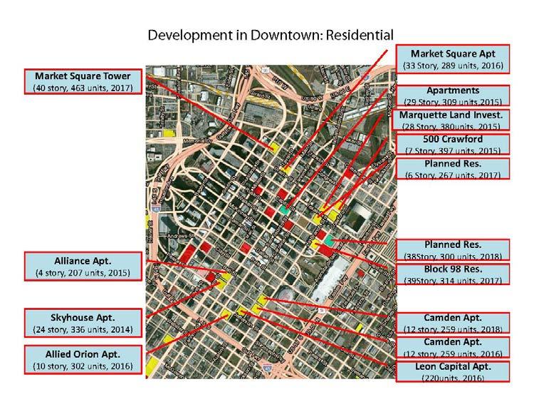
265 Figure - Anticipated Development Downtown - Office Figure - Anticipated Development Downtown - Residential -0

266 Figure - Anticipated Development Downtown - Hotels 0... Transportation Projects in the Community Resources RSA Transportation projects within the Community Resources RSA have been identified using GIS resources provided by the City of Houston. Exhibit a depicts the Major Thoroughfare and Freeway Plan including roadways by capacity (City of Houston 0e). Note that several data layers show where roadways are of sufficient width for certain transportation facility types, including routes that would be suitable for transit corridors. This map shows that the City of Houston aims to provide adequate roadways and plan ahead for other modes especially to serve downtown. Exhibit b shows only the transportation facilities that are proposed for construction or widening. This figure also depicts how built out the Community Resources RSA is. Table - shows miles of roadway types within the Community Resources RSA. Table -: Length in Miles of Transportation Project Types in the Community Resources RSA Status Miles Proposed Freeway Freeway of Sufficient Width 0 Major Thoroughfare of Sufficient Width Major Thoroughfare To Be Widened Proposed Major Thoroughfare Major Collector of Sufficient Width Major Collector To Be Widened Proposed Major Collector -
267 0 Transit Corridor Street of Sufficient Width 0 Minor Collector of Sufficient Width Minor Collector To Be Widened Proposed Minor Collector Source: NHHIP Study Team (City of Houston 0e)... Land Use and Development in the Community Resources RSA H-GAC planning documents have been queried for anticipated development projects and future land use within the Community Resources RSA. Exhibit and Table - show current land use types in the Community Resources RSA. Over,000 acres of land in the Community Resources RSA are developable, which constitutes approximately nine percent of the total RSA, emphasizing the high degree of development in the RSA. Planners and other local experts will be interviewed for additional information about other actions to be considered in the Final EIS. Table -: Current Land Use in the Community Resources RSA Current Land Use Acres Commercial, Government/Medical/Education, Industrial, Multiple, Other Parks/Open Spaces, Residential,0 Undevelopable,0 Unknown Vacant Developable (includes Farming),0 Water 0 Right-of-Way, TOTAL RSA,0 Source: NHHIP Study Team, H-GAC Current Land Use Data Exhibit and Table - show the allocation of land use types in the Community Resources RSA for 00 future land use. According to the H-GAC data, by 00 just under,000 acres of land will be developable in the RSA, which constitutes approximately three percent of the total RSA. Over the planning horizon, development is expected to continue and densify. Parks and open space land are expected to remain preserved. -
268 0 0 Table -: Future Land Use in the Community Resources RSA 00 Land Use Acres Commercial,0 Government/Medical/Education, Industrial, Multiple,0 Other 0 Parks/Open Spaces, Residential, Undevelopable,0 Unknown Vacant Developable (includes Farming), Water 0 Right-of-Way, TOTAL RSA,0 Source: CMEC GIS; H-GAC Future Land Use Data The City of Houston provided projected future development that they classify as near future. Almost,000 acres are already expected to develop in the near future, according to city platting activity records (Mohite 0). H-GAC projects development of,0 acres of currently undeveloped land in the Community Resources RSA through 00 (H-GAC 0c). These figures affirm that development and redevelopment trends would continue within the RSA, and are not necessarily associated with the proposed NHHIP. See Exhibit Projected Future Development and Table - below. Table -: Future Development in the Community Resources RSA Source Acres City of Houston (near term), H-GAC (00),0 Source: NHHIP Study Team, City of Houston and H-GAC Future Land Use Data Examples of Major Projects in the Community Resources RSA - Downtown Many development and redevelopment projects are underway in downtown Houston. The discussion below provides a brief overview of three example projects that were recently competed or ongoing; it is not intended to be comprehensive, but shows dynamic change has been underway for some years and is expected to continue throughout the temporal study area for this analysis. SEARCH provides homeless and marginally homeless with assistance. The organization recently opened a new facility in the NHHIP project area and Community Resources RSA. The building is more than,000 square feet and is next to the Loaves & Fishes soup kitchen and near Minute Maid Park. See Figure -0 SEARCH facility under construction in 0. (Gerbode 0b) -
 Figure - Cheek Neal Coffee Company historic building in redevelopment 0 The redevelopment of the Hardy Yard Rail site, located two blocks north of I-0 near the corner of N.")

269 Figure -0 SEARCH facility under construction in 0 A large-scale historic aged building, the Cheek-Neal Coffee Co. Building, is in redevelopment in the same area. It had been closed since. See Figure -. (Gerbode 0a) Figure - Cheek Neal Coffee Company historic building in redevelopment 0 The redevelopment of the Hardy Yard Rail site, located two blocks north of I-0 near the corner of N. Main St. and Burnett St., includes a dedicated number of affordable housing units. The Residences at Hardy Yards is a component of the Near Northside s first mixed-use development. Approximately 0 apartments are planned to be constructed within acres of the overall 0-acre development site. Houston City Council approved a performance-based loan in federal hurricane relief money during December 0 to the business entity that will develop the 0-acre site. Loan conditions approved by City Council included that of the 0 one and two-bedroom units must be affordable. Nearby infrastructure enhancements are ongoing to bring major water and wastewater improvements to the area (Lomax 0). -
DRAFT. Draft Carbon Monoxide (CO) Traffic Air Quality Analysis
 Traffic Air Quality Analysis") Draft Carbon Monoxide (CO) Traffic Air Quality Analysis North Houston Highway Improvement Project From US 59/I-69 at Spur 527 To I-45 at Beltway 8 North Harris County TxDOT Houston District CSJ: 0912-00-146
Draft Carbon Monoxide (CO) Traffic Air Quality Analysis North Houston Highway Improvement Project From US 59/I-69 at Spur 527 To I-45 at Beltway 8 North Harris County TxDOT Houston District CSJ: 0912-00-146
APPROVAL TO SUBMIT COMMENTS ON I-45 AND MORE DRAFT ENVIRONMENTAL IMPACT STATEMENT
 TAC Agenda Item 09 Mailout 7/12/17 APPROVAL TO SUBMIT COMMENTS ON I-45 AND MORE DRAFT ENVIRONMENTAL IMPACT STATEMENT Background The Texas Department of Transportation, in cooperation with the Federal Highway
This page intentionally left blank.
 Final Environmental Impact Statement: Volume I Grand Parkway (State Highway 99) Segment B: From SH 288 to IH 45 South, Houston District 3510-01-001, 3510-01-003, 3510-02-001, 3510-02-003, 3510-02-004,
SECONDARY WETLAND IMPACTS ANALYSIS
 SECONDARY WETLAND IMPACTS ANALYSIS USACE File. SWG-2012-00153 During the development of the Grand Parkway (State Highway 99) Segments H and I-1 from United States Highway 59/Interstate Highway 69 N to
Indirect and Cumulative Effects
 Chapter 21: Indirect and Cumulative Effects 21-1 INTRODUCTION The federal Council on Environmental Quality s (CEQ) regulations implementing the procedural provisions of the National Environmental Policy
Section 7 Environmental Constraints
 Section 7 Environmental Constraints i Yakima Valley Metropolitan and Regional Transportation Plan Public Comment DRAFT 1/27/2016 Environmental Constraints Analysis A programmatic-level review of potential
Federal Highway Administration FINDING OF NO SIGNIFICANT IMPACT Interstate Highway 45 and Loop 197 Direct Connector Galveston County, Texas
 Federal Highway Administration FINDING OF NO SIGNIFICANT IMPACT Interstate Highway 45 and Loop 197 Direct Connector Galveston County, Texas Introduction The Federal Highway Administration (FHWA) has determined,
12 Evaluation of Alternatives
 12 Evaluation of Alternatives This chapter evaluates the effectiveness of the No-Build Alternative and the proposed METRO Blue Line Light Rail Transit (BLRT) Extension project based on the information
11 Joint Development Regulatory Context and Methodology
 11 Joint Development This chapter describes the long-term direct and potential indirect impacts, and short-term direct and potential indirect impacts, of the proposed METRO Blue Line Light Rail Transit
Northwest State Route 138 Corridor Improvement Project
 Northwest State Route 138 Corridor Improvement Project Los Angeles County, CA DISTRICT 7- LA- 138 (PM 0.0/36.8); DISTRICT 7- LA- 05 (PM 79.5/83.1); DISTRICT 7- LA- 14 (PM 73.4/74.4) 265100/ 0700001816
PUBLIC HEARING LOOP 9
 PUBLIC HEARING LOOP 9 From Interstate (I)-35E to I-45 Dallas and Ellis Counties, Texas CSJ: Loop 2964-10-005 9: I-35E to I-45 Tuesday, June 20, 20, 2017 2017 Public Hearing Introductions ELECTED & PUBLIC
TIER 2 EIS SCOPING MEETING WELCOME TO THE FEDERAL AVIATION ADMINISTRATION SCOPING MEETING
 TIER 2 EIS SCOPING MEETING WELCOME TO THE FEDERAL AVIATION ADMINISTRATION SCOPING MEETING TIER 2 EIS OVERVIEW SOUTH SUBURBAN INAUGURAL AIRPORT ENVIRONMENTAL IMPACT STATEMENT The proposed, (SSA) will require
EXECUTIVE SUMMARY RIVER VALLEY INTERMODAL FACILITIES FINAL ENVIRONMENTAL IMPACT STATEMENT ES-1
 ES.1 INTRODUCTION This Final Environmental Impact Statement (FEIS) for the River Valley Intermodal Facilities (RVIF) in the Arkansas River Valley (ARV) has been written in accordance with the National
University Corridor Draft Environmental Impact Statement (DEIS)
") University Corridor Draft Environmental Impact Statement (DEIS) Public Meetings/Open Houses August 13, 27 August 14, 27 5: pm to 7: pm 5: pm to 7: pm Holiday Inn Select- Greenway* Wheeler Avenue Baptist
University Corridor Draft Environmental Impact Statement (DEIS) Public Meetings/Open Houses August 13, 27 August 14, 27 5: pm to 7: pm 5: pm to 7: pm Holiday Inn Select- Greenway* Wheeler Avenue Baptist
2.1.1 Traffic Noise Analysis
 2.1.1 Traffic Noise Analysis Number: 2.1.1 2.1.1 Name: Traffic Noise Analysis Traffic Noise Analysis Description: This category includes the performance of a traffic This category includes the performance
PUBLIC NOTICE. Section 404 of the Clean Water Act (33 U.S.C. 1344) Section 10 of the Rivers and Harbors Act of 1899 (33 U.S.C.
 Section 10 of the Rivers and Harbors Act of 1899 (33 U.S.C.") US Army Corps Of Engineers Wilmington District PUBLIC NOTICE Issue Date: June 17, 2014 Comment Deadline: July 17, 2014 Corps Action ID#: SAW-2009-00655 NC DOT TIP: R-4903 The Wilmington District, Corps
US Army Corps Of Engineers Wilmington District PUBLIC NOTICE Issue Date: June 17, 2014 Comment Deadline: July 17, 2014 Corps Action ID#: SAW-2009-00655 NC DOT TIP: R-4903 The Wilmington District, Corps
APPENDIX A. NEPA Assessment Checklist
 APPENDI A NEPA Assessment Checklist NEPA CHECKLIST DATE: January 12, 2009 PREPARER: Frederick Wells, RLA PIN and Project Title: Surplus Property Request Wilder Balter Partners Marketplace Town of Newburgh,
FEDERAL HIGHWAY ADMINISTRATION RECORD OF DECISION FOR THE LYNNWOOD LINK EXTENSION
 FEDERAL HIGHWAY ADMINISTRATION RECORD OF DECISION FOR THE LYNNWOOD LINK EXTENSION AUGUST 2015 Table of Contents 1 Decision... 1 1.1 Project Description... 2 1.2 Basis for the FHWA Decision... 7 1.2.1
Categorical Exclusion (CE)
") Categorical Exclusion (CE) Project Information Project Name: Federal Project#: Project Number: 0029-002-135, D624, P101 Project Type: Construction UPC: 77383 Charge Number: Route Number: 29 Route Type:
Categorical Exclusion (CE) Project Information Project Name: Federal Project#: Project Number: 0029-002-135, D624, P101 Project Type: Construction UPC: 77383 Charge Number: Route Number: 29 Route Type:
Public Notice. Applicant: City of Dallas Project No.: SWF Date: April 18, Name: Chandler Peter Phone Number:
 Public Notice Applicant: City of Dallas Project No.: SWF- 2014-00151 Date: April 18, 2014 The purpose of this public notice is to inform you of a proposal for work in which you might be interested. It
Environmental Impact Statement for the Green Line to the Airport Project. ACTION: Notice of Intent to Prepare an Environmental Impact Statement (EIS).
.") This document is scheduled to be published in the Federal Register on 11/18/2015 and available online at http://federalregister.gov/a/2015-29418, and on FDsys.gov DEPARTMENT OF TRANSPORTATION Federal Transit
This document is scheduled to be published in the Federal Register on 11/18/2015 and available online at http://federalregister.gov/a/2015-29418, and on FDsys.gov DEPARTMENT OF TRANSPORTATION Federal Transit
ENVIRONMENTAL ASSESSMENT
 ENVIRONMENTAL ASSESSMENT Section 408 Request to Alter the Dubois Local Protection Project for the Beaver Drive sidewalk construction in Clearfield County, PA June 28, 2018 Prepared By: Environmental and
Categorical Exclusion Programmatic Agreement Between the Federal Highway Administration And the Indiana Department of Transportation
 Categorical Exclusion Programmatic Agreement Between the Federal Highway Administration And the Indiana Department of Transportation Introduction The Indiana Department of Transportation (INDOT) and the
PUBLIC HEARING US 69 WIDENING. Phase 1 (IH-10 to LNVA Canal) Phase 2 (LNVA Canal to Tram Road) Jefferson County, Texas
 Phase 2 (LNVA Canal to Tram Road) Jefferson County, Texas") PUBLIC HEARING US 69 WIDENING Phase 1 (IH-10 to LNVA Canal) Phase 2 (LNVA Canal to Tram Road) Jefferson County, Texas CSJs: 0065-07-062 and 0200-11-095 Footer Text Thursday, April 26, 2018 Date ELECTED
PUBLIC HEARING US 69 WIDENING Phase 1 (IH-10 to LNVA Canal) Phase 2 (LNVA Canal to Tram Road) Jefferson County, Texas CSJs: 0065-07-062 and 0200-11-095 Footer Text Thursday, April 26, 2018 Date ELECTED
City of Bishop. Environmental Checklist Form
 City of Bishop Environmental Checklist Form 1. Project title: Environmental Review / 2007 California Building Codes 2. Lead agency name and address: City of Bishop 377 W. Line Street Bishop, Ca 93514 3.
APPENDIX M CEQA Initial Study Checklist
 APPENDIX M CEQA Initial Study Checklist Appendix G ENVIRONMENTAL CHECKLIST FORM (To be Completed by Applicant) 1. Project title: 2. Lead agency name and address: 3. Contact person and phone number: 4.
THIS IS NOT A PAID ADVERTISEMENT. Public Notice. Public Notice No. CENAP-OP-R October 26, 2018
 THIS IS NOT A PAID ADVERTISEMENT Public Notice Wanamaker Building 100 Penn Square East Philadelphia, PA 19107-3390 ATTN: CENAP-OP-R Public Notice No. Date CENAP-OP-R-2018-822 October 26, 2018 Application
October 19, 2017 Community Engagement Panel Meeting #4 Overview of Environmental Effects
 Lake Elmo Airport Environmental Assessment (EA)/ Environmental Assessment (EAW) Worksheet October 19, 2017 Community Engagement Panel Meeting #4 Overview of Environmental Effects Agenda Public Event #2
Interstate 73 FEIS: I-95 to the Myrtle Beach Region Chapter 4. Public Involvement and Agency Coordination
 4-65 Interstate 73 FEIS: I-95 to the Myrtle Beach Region 4-66 Comment noted. The use of existing roadways was considered during alternative development (refer to Chapter 2, Section 2.1, page 2-1 and the
U.S. DEPARTMENT OF TRANSPORTATION Federal Highway Administration. RECORD OF DECISION March 2013
 U.S. DEPARTMENT OF TRANSPORTATION Federal Highway Administration RECORD OF DECISION March 2013 Grand Parkway (State Highway 99) Segment C From United States Highway 59 (US 59) To State Highway 288 (SH
Work Breakdown Structure Element Dictionary Preliminary Engineering
 Element Name Initiation PE 3.1 Initiation includes the implementation of the project s funding and notification of the consultant or in-house design staff to commence work, the Kickoff Meeting with the
Project Information. Pursuant to Section 404 of the Clean Water Act (33 U.S. Code 1344), notice is hereby given that
, notice is hereby given that") US ARMY Corps Of Engineers Little Rock District JOINT PUBLIC NOTICE CORPS OF ENGINEERS STATE OF ARKANSAS Application Number: 2014-00083-1 Date: December 22, 2014 Comments Due: January 16, 2015 TO WHOM
US ARMY Corps Of Engineers Little Rock District JOINT PUBLIC NOTICE CORPS OF ENGINEERS STATE OF ARKANSAS Application Number: 2014-00083-1 Date: December 22, 2014 Comments Due: January 16, 2015 TO WHOM
U.S. DEPARTMENT OF TRANSPORTATION Federal Highway Administration. RECORD OF DECISION June 2014
 U.S. DEPARTMENT OF TRANSPORTATION Federal Highway Administration RECORD OF DECISION June 2014 Grand Parkway (State Highway 99) Segments H and I-1 From United States Highway (US) 59 North/Interstate Highway
J O I N T P U B L I C N O T I C E
 J O I N T P U B L I C N O T I C E CHARLESTON DISTRICT, CORPS OF ENGINEERS 69A Hagood Avenue Charleston, SC 29403-5107 and THE S.C. DEPARTMENT OF HEALTH AND ENVIRONMENTAL CONTROL Water Quality Certification
SECTION 9.0 Effects Found Not To Be Significant
 SECTION 9.0 Effects Found Not To Be Significant 9.0 EFFECTS FOUND NOT TO BE SIGNIFICANT The City of Santa Clarita conducted an Initial Study in April 2006 to determine significant effects of the proposed
16.1 Significant and Unavoidable Impacts
 Chapter 16 NEPA requires an EIS and CEQA requires an EIR to evaluate a number of other types of environmental impacts in addition to those already addressed in the resource chapters. The analysis required
Categorical Exclusion (CE)
") Categorical Exclusion (CE) Project Information Project Name: I-66 ITB West Falls Church Metro Garage Access Federal Project#: NHPP-066-1(356) Project Number: 0066-96A-493, B686, C501, P101 Project Type:
Categorical Exclusion (CE) Project Information Project Name: I-66 ITB West Falls Church Metro Garage Access Federal Project#: NHPP-066-1(356) Project Number: 0066-96A-493, B686, C501, P101 Project Type:
CESAM-RD-N May 29, 2014 PUBLIC NOTICE NO. SAM JSC
 DEPARTMENT OF THE ARMY U.S. ARMY CORPS OF ENGINEERS MOBILE DISTRICT MONTGOMERY FIELD OFFICE 605 MAPLE STREET BUILDING 1429, ROOM 105 MAXWELL AFB, AL 36112 CESAM-RD-N May 29, 2014 PUBLIC NOTICE NO. SAM-2014-00173-JSC
Summary. Preliminary Alternative Development and Screening. DEIS July 23, 2018
 What is the Carolina Crossroads Project? The South Carolina Department of Transportation (SCDOT), in cooperation with the Federal Highway Administration (FHWA), is proposing to upgrade and redesign a key
SECTION 6.0 Alternatives to the Proposed Project
 SECTION 6.0 Alternatives to the Proposed Project 6.0 ALTERNATIVES TO THE PROPOSED PROJECT CEQA requires that an EIR include an analysis of a range of project alternatives that could feasibly attain most
Executive Summary. What is the I-70 East EIS project and where is it located?
 The Executive Summary of the Supplemental Draft Environmental Impact Statement (EIS) provides an overview of the project, including the project purpose and need, project description, evaluated alternatives,
Categorical Exclusion (CE)
") Categorical Exclusion (CE) Project Information Project Name: Rte 130 Bridge Replacement over Pedlar River Federal Project#: BR-005-3(116) Project Number: 0130-005-643, B650, C501, P101, R201 Project Type:
Categorical Exclusion (CE) Project Information Project Name: Rte 130 Bridge Replacement over Pedlar River Federal Project#: BR-005-3(116) Project Number: 0130-005-643, B650, C501, P101, R201 Project Type:
5.0 LONG-TERM CEQA CONSIDERATIONS
 5.0 LONG-TERM CEQA CONSIDERATIONS Section 15126 of the CEQA Guidelines requires that all phases of a project must be considered when evaluating its impact on the environment, including planning, acquisition,
FINDINGS OF FACT and CONCLUSIONS
 FINDINGS OF FACT and CONCLUSIONS I-694/ I-494/ I-94 Interchange Improvements State Project No. 8286-81 Prepared by: Minnesota Department of Transportation July, 2018 CONTENTS STATEMENT OF ISSUE... 2 ADMINISTRATIVE
4 COMMITMENTS 4.1 LAND USE AND LAND COVER
 4 COMMITMENTS Each Affected Environment and Environmental Consequences Subsection contains commitments specific to the impact area being assessed. This section contains a summary of the commitments that
FINDINGS OF FACT And CONCLUSIONS
 FINDINGS OF FACT And CONCLUSIONS SOUTHWEST RECONNECTION PROJECT Highway 61/101 Flood Mitigation State Project No. 1009-24 and State Aid Project No. 010-661-002 Prepared for: Carver County September 2013
Public Notice U.S. ARMY CORPS OF ENGINEERS, GALVESTON DISTRICT AND TEXAS COMMISSION ON ENVIRONMENTAL QUALITY
 Public Notice U.S. Army Corps Permit Application No: SWG-2007-00247 Of Engineers Date Issued: 26 September 2017 Galveston District Comments Due: 26 October 2017 U.S. ARMY CORPS OF ENGINEERS, GALVESTON
Washington Dulles International Airport EXECUTIVE SUMMARY
 EXECUTIVE SUMMARY The events of September 11, 2001 and the economic uncertainties facing commercial aviation have affected the timing of the Proposed Action. The Metropolitan Washington Airports Authority
6.0 Indirect Effects and Cumulative Impacts
 6.0 Effects and Impacts 6.1 Introduction This chapter of the Draft EIS addresses potential indirect and cumulative impacts of the Bottineau Transitway project. effects are those that are caused by the
D R A F T. SECTION 4(f) EVALUATION. INTERSTATE 73 From I-95 to the Myrtle Beach Region
 EVALUATION. INTERSTATE 73 From I-95 to the Myrtle Beach Region") D R A F T SECTION 4(f) EVALUATION INTERSTATE 73 From I-95 to the Myrtle Beach Region INTRODUCTION Section 4(f) of the Department of Transportation Act of 1966, 49 USC 303 requires that prior to the use
D R A F T SECTION 4(f) EVALUATION INTERSTATE 73 From I-95 to the Myrtle Beach Region INTRODUCTION Section 4(f) of the Department of Transportation Act of 1966, 49 USC 303 requires that prior to the use
OPTIONAL STATIONAVIATION/MANCHESTER
 CRENSHAW/LAX TRANSIT CORRIDOR PROJECT FEIS/FEIR OPTIONAL STATIONAVIATION/MANCHESTER Aviation and Manchester, Looking East Aviation/Manchester Station (Optional) The Optional Aviation/Manchester Station
DEPARTMENT OF THE ARMY U.S. ARMY CORPS OF ENGINEERS - MOBILE DISTRICT BIRMINGHAM FIELD OFFICE 218 SUMMIT PARKWAY, SUITE 222 HOMEWOOD, AL 35209
 DEPARTMENT OF THE ARMY U.S. ARMY CORPS OF ENGINEERS - MOBILE DISTRICT BIRMINGHAM FIELD OFFICE 218 SUMMIT PARKWAY, SUITE 222 HOMEWOOD, AL 35209 CESAM-RD-I-N December 7, 2012 PUBLIC NOTICE NO. SAM-2012-01506-LCB
Willmar Wye Public Open House #4 and Public Hearing
 Willmar Wye Public Open House #4 and Public Hearing February 23, 2017 www.dot.state.mn.us/d8/willmarwye Agenda Time Topic 5:00 pm Open House Opportunity for the public to ask questions of project staff
Environmental Impact Statement; Lone Star Regional Rail Project Williamson, Travis, Bastrop, Hays, Caldwell, Comal, Guadalupe, and Bexar Counties, TX
 This document is scheduled to be published in the Federal Register on 10/06/2014 and available online at http://federalregister.gov/a/2014-23711, and on FDsys.gov [4910-22] DEPARTMENT OF TRANSPORTATION
Welcome. Public Meeting. August 2, :00 to 7:00 p.m. Presentation 6:00 to 6:30 p.m.
 Welcome Public Meeting August 2, 2017 5:00 to 7:00 p.m. Presentation 6:00 to 6:30 p.m. www.glenwoodsouthbridge.net Welcome to the South Bridge Environmental Assessment Public Meeting Why Are We Here Tonight?
ES.1 What is the I-70 East EIS project and where is it located?
 EXECUTIVE SUMMARY The Executive Summary of the Final Environmental Impact Statement (EIS) provides an overview of the project, including the project purpose and need, project description, evaluated alternatives,
5. Other Environmental Consequences
 5. Other Environmental Consequences 5.1 Unavoidable Adverse Impacts Impacts to the following environmental resources were evaluated for Alternative D, the preferred alternative, to determine if they would
NEPA and Design Public Hearings
 NEPA and Design Public Hearings Monday, December 5, 2016 Washington-Lee High School 1301 N. Stafford Street Arlington, VA 22201 Thursday, December 8, 2016 Mary Ellen Henderson Middle School 7130 Leesburg
APPENDIX H NEPA TRANSITION REPORT
 APPENDIX H NEPA TRANSITION REPORT BORDER HIGHWAY EAST STUDY CSJ: 0-0-00 EL PASO COUNTY, TEXAS TEXAS DEPARTMENT OF TRANSPORTATION The environmental review, consultation, and other actions required by applicable
Abbreviated State Final Environmental Impact Statement
 Loop 375 Border Highway West Extension Project From Racetrack Drive to U.S. Highway 54 El Paso County, Texas CSJ: 2552-04-027 Abbreviated State Final Environmental Impact Statement Texas Department of
Oklahoma Department of Transportation Environmental Programs Division Office Fax
 Oklahoma Department of Transportation Environmental Programs Division Office 521-3050 Fax 522-5193 Documented Categorical Exclusion (DCE) for I-40: Pavement Reconstruction and Added Lanes from the Douglas
Taylorsville-Murray Transit
 Taylorsville-Murray Transit Environmental Study Report April 2013 Prepared for Table of Contents Acronyms & Abbreviations... iv Executive Summary... ES 1 Chapter 1: Purpose and Need 1.1 Project Description...
An Overview and Comparison of the Tennessee Department of Transportation s Environmental Evaluation Process
 Introduction This document provides a brief overview of the policy and procedures that govern the environmental evaluation process that the Tennessee Department of Transportation (TDOT) must follow for
SUPPLEMENTAL DRAFT ENVIRONMENTAL IMPACT STATEMENT NORTH BELT FREEWAY SUMMARY INTRODUCTION
 SUMMARY INTRODUCTION The Arkansas State Highway and Transportation Department (AHTD), in cooperation with the Federal Highway Administration (FHWA), is proposing a highway project located in northern Pulaski
Public Notice. Applicant: Lennar Homes Project No.: SWF Date: October 29, Name: Mr. Darvin Messer Phone Number:
 Public Notice Applicant: Lennar Homes Project No.: SWF-2013-00265 Date: October 29, 2013 The purpose of this public notice is to inform you of a proposal for work in which you might be interested. It is
Appendix. Sample EA/EIS Scope of Work
 Appendix K Sample EA/EIS Scope of Work EA/EIS Sample Scope of Work The purpose of this Scope of Work (SOW) is to prepare an EA document pursuant to the National Environmental Policy Act (NEPA) to analyze
Letter to Ms. Wallace. March 24, 2014
 March 24, 2014 1 FIGURE 1 2 FIGURE 2 Project Limits 3 CE Provisions Relative to the Project Pursuant to the provisions of 23 CFR 771.118(d), (or d-list), the Federal Highway Administration (FHWA) and FTA
DRAFT FINDING OF NO SIGNIFICANT IMPACT ADDRESSING AN ARMY AND AIR FORCE EXCHANGE SERVICE LIFESTYLE CENTER AT FORT SAM HOUSTON, SAN ANTONIO, TEXAS
 1 1 1 1 1 0 1 0 1 0 1 DRAFT FINDING OF NO SIGNIFICANT IMPACT ADDRESSING AN ARMY AND AIR FORCE EXCHANGE SERVICE LIFESTYLE CENTER AT FORT SAM HOUSTON, SAN ANTONIO, TEXAS Pursuant to the Council on Environmental
Public Notice U.S. ARMY CORPS OF ENGINEERS, GALVESTON DISTRICT AND TEXAS COMMISSION ON ENVIRONMENTAL QUALITY
 Public Notice U.S. Army Corps Permit Application No: SWG-2016-00959 Of Engineers Date Issued: 28 November 2017 Galveston District Comments Due: 13 December 2017 U.S. ARMY CORPS OF ENGINEERS, GALVESTON
Northern Intermodal Transit Facility WHAT IS AN INTERMODAL TRANSIT FACILITY?
 WHAT IS AN INTERMODAL TRANSIT FACILITY? An intermodal transit facility gathers many modes of transportation together and is strategically located to increase destination alternatives. Intermodal facilities
Public Notice U.S. ARMY CORPS OF ENGINEERS, GALVESTON DISTRICT AND TEXAS COMMISSION ON ENVIRONMENTAL QUALITY
 Public Notice U.S. Army Corps Permit Application No: SWG-2018-00181 Of Engineers Date Issued: 6 September 2018 Galveston District Comments Due: 8 October 2018 U.S. ARMY CORPS OF ENGINEERS, GALVESTON DISTRICT
SUMMARY S.1 PROJECT DESCRIPTION AND LOCATION S.2 PURPOSE AND NEED
 S SUMMARY S.1 PROJECT DESCRIPTION AND LOCATION The Virginia Department of Transportation (VDOT), in cooperation with the Federal Highway Administration (FHWA), is studying alternatives to meet transportation
Appendix E: Environmental Mitigation
 Appendix E: Environmental Mitigation This page intentionally left blank. Table of Contents Introduction... 2 Methodology... 2 Common Environmental Issues... 3 Streams and Wetlands... 3 Endangered and Threatened
5.15 Wetlands and Other Waters of the U.S.
 I-70 East Final EIS 5.15 Wetlands and Other Waters of the U.S. 5.15 Wetlands and Other Waters of the U.S. This section discusses wetlands, open waters, and other waters of the U.S. in the study area and
SOUTHWEST LRT (METRO GREEN LINE EXTENSION)
") 8 Evaluation of Alternatives This chapter evaluates the effectiveness of the No Build Alternative and the Southwest Light Rail Transit (LRT) Project (the Project) based on the information contained in
8 Evaluation of Alternatives This chapter evaluates the effectiveness of the No Build Alternative and the Southwest Light Rail Transit (LRT) Project (the Project) based on the information contained in
5.0 PRELIMINARY ENVIRONMENTAL REVIEW
 5.0 PRELIMINARY ENVIRONMENTAL REVIEW 5.1 INTRODUCTION A preliminary environmental review was performed on the proposed freeway improvements that form Concept C, which encompasses the three freeway corridors
Lubbock Outer Route Feasibility Study Report Executive Summary
 Lubbock Outer Route Feasibility Study Report Executive Summary Prepared for: Texas Department of Transportation Lubbock District Prepared by: MACTEC Engineering and Consulting, Inc. 6701 Aberdeen, Suite
ENVIRONMENTAL ASSESSMENT
 ENVIRONMENTAL ASSESSMENT Section 408 Request to Alter the Brookville Local Protection Project for State Route 3033 Bridge Replacement in Jefferson County, PA May 16, 2018 Prepared By: Environmental and
IH 30/IH 35E Reconstruction Project Pegasus Final Technical Memorandum - Evaluation of Conceptual Alternatives Task 7.5
 MEMO TO: Timothy Nesbitt, P.E. DATE: August 26, 2002 FROM: SUBJECT: Sandy Wesch-Schulze, P.E., AICP IH 30/IH 35E Reconstruction Project Pegasus Final Technical Memorandum - Evaluation of Conceptual Alternatives
Executive Summary. ES.1 Project Overview
 ES.1 Project Overview The New Hampshire Department of Transportation (NHDOT) and the Federal Highway Administration (FHWA) have prepared this Environmental Assessment/Draft Section 4(f) Evaluation (EA/4(f))
I-20 East Transit Initiative
 I-20 East Transit Initiative Open Houses Monday, June 24 6 7 PM: Open House 7 8 PM: Presentation & Q/A City of Atlanta Old Council Chambers Atlanta City Hall 55 Trinity Avenue Atlanta, GA 30303 Tuesday,
Puget Sound Gateway Program Phase 1 of the SR 509 Completion Project
 Puget Sound Gateway Program Phase 1 of the SR 509 Completion Project 23 CFR 771.129 Washington State Department of Transportation/Federal Highway Administration REGION/MODE SR PROJECT PROGRAM# FEDERAL
Lynnwood Link Extension 2013 Draft EIS Comments and Responses. Page 945
 I-441-001 Thank you for your comments about the importance of the Latvian Center to the Latvian community. Following the Draft EIS, the Sound Transit Board directed Sound Transit to develop a Preferred
RESOLUTION NO:
 RESOLUTION NO: 11-031 A RESOLUTION OF THE CITY COUNCIL OF THE CITY OF PASO ROBLES CERTIFYING THE FINAL ENVIRONMENTAL IMPACT REPORT FOR THE 2011 CIRCULATION ELEMENT OF THE GENERAL PLAN AND ADOPTING FINDINGS,
State Route 8 Bridge Replacement Project
 OPEN HOUSE PUBLIC INVOLVEMENT MEETING Celebration Church 688 Dan Street, Akron, Ohio Tuesday, July 14, 2015 5:00 PM to 7:00 PM State Route 8 Bridge Replacement Project Existing Bridge Future Bridges: Steel
Public Notice ISSUED: 20-JAN-2016 EXPIRES: 19-FEB-2016
 APPLICANT: Shakopee Mdewakanton Sioux Community Public Notice ISSUED: 20-JAN-2016 EXPIRES: 19-FEB-2016 REFER TO: MVP-2015-04726-RMM SECTION: 404 - Clean Water Act 1. APPLICATION FOR PERMIT TO discharge
Public Notice October 21, 2016 U.S. Army Corps of Engineers Charleston District
 Public Notice October 21, 2016 U.S. Army Corps of Engineers Charleston District Notice of Intent to Prepare a Draft Environmental Impact Statement for the Proposed Jasper Ocean Terminal in Jasper County,
J O I N T P U B L I C N O T I C E
 DEPARTMENT OF THE ARMY U.S. ARMY CORPS OF ENGINEERS, SAVANNAH DISTRICT 100 W. OGLETHORPE AVENUE SAVANNAH, GEORGIA 31401-3604 J O I N T P U B L I C N O T I C E CHARLESTON AND SAVANNAH DISTRICTS- US ARMY
SECTION 5: ALTERNATIVES TO THE PROPOSED PROJECT
 City of American Canyon Broadway District Specific Plan Alternatives to the Proposed Project SECTION 5: ALTERNATIVES TO THE PROPOSED PROJECT 5.1 Introduction In accordance with CEQA Guidelines Section
Public Notice ISSUED: March 18, 2016 EXPIRES: April 18, 2016
 APPLICANT: REFER TO: Mattamy Homes 2005-04142-PRH Public Notice ISSUED: March 18, 2016 EXPIRES: April 18, 2016 SECTION: 404 - Clean Water Act 1. APPLICATION FOR PERMIT to discharge dredged and fill material
St. Francis Drive through the City of Santa Fe Corridor Study
 VIII. ENGINEERING AND ENVIRONMENTAL EVALUATION INTERSECTION IMPROVEMENTS SOUTHERN For the southern end of the corridor, traffic volumes are expected to increase over existing levels. The Phase A Report
Public Notice ISSUED: July 13, 2018 EXPIRES: August 13, 2018
 APPLICANT: Sargento Foods Inc. Public Notice ISSUED: July 13, 2018 EXPIRES: August 13, 2018 REFER TO: 2010-2909-RJH SECTION: 404 - Clean Water Act 1. APPLICATION FOR PERMIT TO discharge dredged and fill
LONG ISLAND RAIL ROAD EXPANSION PROJECT FROM FLORAL PARK TO HICKSVILLE DRAFT ENVIRONMENTAL IMPACT STATEMENT
 LONG ISLAND RAIL ROAD EXPANSION PROJECT FROM FLORAL PARK TO HICKSVILLE DRAFT ENVIRONMENTAL IMPACT STATEMENT Project Name: Project Location: Lead Agency & Contact Person: SEQRA Classification: Project Sponsors:
Federal Aviation Administration
 U.S. Department of Transportation Federal Aviation Administration DRAFT Environmental Impact Statement for Proposed Redevelopment and Extension of Runway 9R/27L March 30, 2007 Fort Lauderdale-Hollywood
PUBLIC NOTICE. Mr. Jon Morris Beacon Partners, Inc 610 East Morehead Street Charlotte, North Carolina 28202
 US Army Corps Of Engineers Wilmington District PUBLIC NOTICE Issue Date: July 31, 2013 Comment Deadline: August 30, 2013 Corps Action ID Number: SAW-2013-01263 The Wilmington District, Corps of Engineers
Carpinteria Valley Water District Carpinteria Advanced Purification Project
 NOTICE OF PREPARATION AND SCOPING MEETING Carpinteria Valley Water District Carpinteria Advanced Purification Project TO: Agencies, Organizations, and Interested Parties DATE: January 7, 2019 SUBJECT:
Background. FHWA Decisions
 The Federal Highway Administration (FHWA) has reviewed the Virginia Department of Transportation s (VDOT) March 30, 2017 letter requesting a Finding of No Significant Impact, the Revised Environmental
Public Notice ISSUED: April 5, 2019 EXPIRES: May 6, 2019
 APPLICANT: Aitkin County Highway Department Public Notice ISSUED: April 5, 2019 EXPIRES: May 6, 2019 REFER TO: MVP-2019-00387-EJI SECTION: 404 - Clean Water Act 1. APPLICATION FOR PERMIT TO discharge fill
TABLE OF CONTENTS 3.0 AFFECTED ENVIRONMENT AND ENVIRONMENTAL CONSEQUENCES
 TABLE OF CONTENTS 1.0 PURPOSE AND NEED -------------------------------------------------------------------------------------------- 1-1 1.1 STUDY AREA -----------------------------------------------------------------------------------------------------
I-20 East Transit Initiative
 I-20 East Transit Initiative Technical Advisory Committee (TAC) Meeting June 11 th, 2013 Introductions Purpose of Today s Meeting Project Review Preliminary Environmental Findings Next Steps Project Status