FINDINGS OF FACT And CONCLUSIONS
|
|
|
- Sylvia Lee
- 5 years ago
- Views:
Transcription


1 FINDINGS OF FACT And CONCLUSIONS SOUTHWEST RECONNECTION PROJECT Highway 61/101 Flood Mitigation State Project No and State Aid Project No Prepared for: Carver County September 2013
2
3 TABLE OF CONTENTS Table of Contents... i 1.0 ADMINISTRATIVE BACKGROUND PROJECT DESCRIPTION DECISION REGARDING NEED FOR ENVIRONMENTAL IMPACT STATEMENT... 2 Type, Extent, and Reversibility of Impacts... 2 Cumulative Potential Effects of Related or Reasonably Foreseeable Future Projects... 4 Extent to Which the Environmental Effects are Subject to Mitigation by Ongoing Public Regulatory Authority... 4 Extent to Which Environmental Effects can be Anticipated and Controlled as a Result of Other Environmental Studies CONCLUSIONS... 5 APPENDIX A EAW Public and Agency Comments and Responses EQB Notice of Availability Local Media Press Release MnDOT Press Release APPENDIX B Southwest Reconnection Project Preliminary Layout (2 sheets) Southwest Reconnection Project: highway 61/101 Flood Mitigation SP & SAP Page i
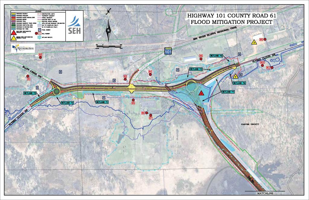
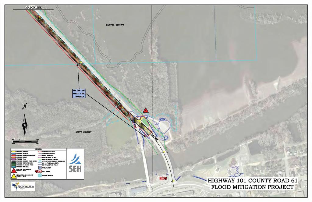
4 FINDINGS OF FACT AND CONCLUSIONS SOUTHWEST RECONNECTION PROJECT HIGHWAY 61/101 FLOOD MITIGATION CHANHASSEN AND SHAKOPEEWOOD CARVER AND SCOTT COUNTIES, MINNESOTA 1.0 ADMINISTRATIVE BACKGROUND Carver County is the Responsible Governmental Unit and project proposer for the Southwest Reconnection Project. An Environmental Assessment Worksheet (EAW) has been prepared for this project in accordance with Minnesota Rules Chapter The EAW was developed to assess the impacts of the project and other circumstances in order to determine if an Environmental Impact Statement (EIS) is indicated. The EAW was filed with the Minnesota EQB and circulated for review and comments to the required EAW distribution list. A Notice of Availability was published in the EQB Monitor on May A press release was distributed to the Chaska Herald and Waconia Patriot. A notice was also published on the project web page at These notices provided a brief description of the project and information on where copies of the EAW were available, and invited the public to provide comments that would be used in determining the need for an EIS on the proposed project. A public open house meeting was also held on Wednesday, June 26, 2013, at the Chanhassen Library. The public meeting presented the preliminary layout and identified potential environmental impacts of the project. The EAW was made available for public review at the Chanhassen City Hall, Shakopee City Hall, Chanhassen Public Library, Carver County Public Works, Scott County Highway Department, and MnDOT Metro District Offices. Comments were received through Wednesday, July 3, All comments received during the EAW comment period were considered in determining the potential for significant environmental impacts. Comments received during the comment period, and responses to the comments are provided in Appendix A. Additional information pertaining to the publication of the EAW and the public open house meeting is located in Appendix A. 2.0 PROJECT DESCRIPTION The proposed Southwest Reconnection Project includes the construction of a new 4,226- foot long four-lane bridge over the Minnesota River floodplain area and will include roadway safety and capacity improvements to Carver County State Aid Highway 61 (also known as Flying Cloud Drive) from approximately 475 feet west of Bluff Creek Drive to approximately 350 feet east of the Highway 61/101 Wye intersection. The project features pedestrian/bicycle trail improvements including a 10-foot off-road trail located on the southwest side of the proposed river/floodplain bridge. The trail corridor is proposed to cross under CSAH 61 (Flying Cloud Drive) in a shared bridge Southwest Reconnection Project: Highway 61/101 Flood Mitigation Page 1 SP & SAP
5 crossing with Bluff Creek. An 8-foot off-road trail will extend east along the north side of CSAH 61 (Flying Cloud Drive) to the eastern project termini, which will connect to a future trail corridor in Hennepin County. The proposed trail will also extend west to Bluff Creek Drive where the trail will ultimately connect to the Minnesota River Valley LRT Trail. Several drainage and water quality features are also proposed to collect, convey, and/or treat surface water runoff. These features include drainage ditches, grass swales, infiltration ponds, and wet detention ponds. A complete description of the project was included in Section III.C.2 of the EA/EAW. Corrections to the EAW or Project Changes Since the EAW was Published Since the EAW was published, the following project items have changed or been updated: No substantial roadway design changes have occurred since the publication of the EA/EAW. A copy of the preliminary layout is presented in Appendix B. Additional Phase II archaeological investigations have been occurring throughout the study area. While no new sites have been identified, the extent of an existing site has been expanded. The findings and mitigation recommendations for the Phase III (data recovery) will be documented in a Memorandum of Agreement (MOA). It is anticipated that the stipulations of the MOA will be completed during the initial stages of construction. 3.0 DECISION REGARDING NEED FOR ENVIRONMENTAL IMPACT STATEMENT Type, Extent, and Reversibility of Impacts Carver County finds that the analysis completed for the EAW is adequate to determine whether the project has the potential for significant environmental effects. The EAW described the type and extent of impacts anticipated to result from the proposed project. This Findings of Fact and Conclusions (FOF&C) document provides clarifications and additional information since the EAW was published. Following are the findings regarding potential environmental impacts of the proposed project and the design features included to avoid, minimize, and mitigate these impacts: Right-of-Way Within the project area, the proposed improvements will require acquisition of approximately 1.68 acres of permanent right-of-way from four privately owned parcels. An additional 5.14 acres of temporary easements will be needed from eight parcels. No full acquisitions/relocations are proposed at this time. The Uniform Relocation Assistance and Real Property Acquisition Policies Act of 1970, as amended and 49 CFR Part 24 provides that assistance be granted to persons, businesses, farms, and non-profit organizations that are displaced by public improvements, such as the Southwest Reconnection Project. Southwest Reconnection Project: Highway 61/101 Flood Mitigation Page 2 SP & SAP
6 Fish, Wildlife, and Ecologically Sensitive Resources A segment of the project area lies adjacent to two wildlife management areas; US Fish and Wildlife Service (FWS) MN Valley National Wildlife Refuge and the DNR Raquet Wildlife Management Area. The floodplain habitat found adjacent to the highway corridor primarily consists of forested wetlands and grasslands. The project proposes to bridge the floodplain area and in return remove the fill from the exiting highway thus providing a benefit to wildlife passage and the surrounding wetlands. The project also proposes to add water quality treatment features that will collect, convey, and treat surface water prior to discharging to receiving water bodies. Vegetation protection measures will also be applied and will be based on MnDOT Standard Specification for Construction 2572 (Protection and Restoration of Vegetation) and specific requests from the MNDNR. Erosion and Sedimentation Erosion and sedimentation of all exposed soils within the project corridor will be minimized by employing best management practices (BMPs) during construction. Ditches, dikes, silt fences, bale checks, sedimentation basins, and temporary seeding are some of the typical temporary erosion control measures that will be used during construction. Temporary and permanent erosion control plans will be identified in the final site grading and in construction plans for each stage of construction, as required by the NPDES permit. Erosion control measures will be in place and maintained throughout the entire construction period. Removal of erosion measures will not occur until all disturbed areas have been stabilized. In addition, at the start of the project adequate practices to prevent sediment from entering Bluff Creek and the Minnesota River will be installed concurrently or within 24hrs of the start of the project. These practices will be maintained or improved as needed for the duration of the project. Erosion control practices defined in the Minnesota Pollution Control Agency s General Stormwater Permit for Construction Activity will be followed. Water Quality/Storm Water Management The proposed project will create approximately 4.0 acres of new impervious surface. The quality and quantity of the additional runoff will be controlled by new collection, conveyance and treatment features that will include drainage ditches, grass swales, infiltration ponds, and wet detention ponds. The ponds will be designed to treat runoff from the added impervious area and will be constructed consistent with the NPDS permit requirements. As a result of the proposed water quality treatment features and various best management practices on this proposed project, the water quality and quantity of the offsite drainage is expected to be improved to that of the existing condition. Wetlands This project will have approximately 5.94acres of wetland impacts. A wetland mitigation plan for replacement of the affected wetland areas will be developed consistent with the current WCA regulatory requirements. A wetland technical evaluation panel (TEP) meeting was held on July 23, 2013 to discuss the project and potential impacts to wetlands. At that meeting, the Board of Water and Soil Resources (BWSR) indicated that wetland impacts associated with the roadway improvements could be mitigated through the use of Southwest Reconnection Project: Highway 61/101 Flood Mitigation Page 3 SP & SAP
7 BWSR wetland bank credits. Mitigation for other project improvements (pedestrian facilities, ponding areas, etc.) will be required to use another form of mitigation. The TEP discussed the possibility of using the removal of the existing land bridge material as on-site mitigation as this area is expected to return to natural floodplain habitat and wetlands. Cumulative Potential Effects of Related or Reasonably Foreseeable Future Projects The area surrounding the project is transitioning from rural to more densely urban/suburb development. The cities of Chanhassen and Shakopee have identified some future development opportunities in the surrounding area. However, as described on pages 44 through 48 in the EAW, there is a low potential for significant cumulative effects from the proposed project and other reasonably foreseeable future actions. Extent to Which the Environmental Effects are Subject to Mitigation by Ongoing Public Regulatory Authority The mitigation of environmental impacts will be designed and implemented in coordination with regulatory agencies and will be subject to the plan approval and permitting process. Permits and approvals that have been obtained or may be required prior to project construction include those listed in Table 1. Table 1 Agency Approvals and Permits Unit of government Type of application Status Federal U.S. Army Corps of Engineers Section 404 Permit To be applied for Section 10 To be applied for U.S. Fish & Wildlife Service Special Use Permit Bluff Creek Realignment To be applied for Minnesota Pollution Control Agency State National Pollutant Discharge Elimination System (NPDES) Construction Stormwater Permit To be applied for 401 Water Quality Certification To be applied for Department of Natural Resources Public Waters Work Permit To be applied for Water Appropriations Permit - Dewatering Utilities Crossing Permit (River) Land Transfer Local To be applied for To be applied for Pending Carver County EAW Approval Complete EIS Need Decision Pending City of Chanhassen Wetland Conservation Act (WCA) Pending City of Shakopee Wetland Conservation Act (WCA) Pending Lower Minnesota River Watershed District Preliminary Layout/Water Quality Treatment Review Pending Southwest Reconnection Project: Highway 61/101 Flood Mitigation Page 4 SP & SAP
8
9 APPENDIX A EAW PUBLIC AND AGENCY COMMENTS &RESPONSES EQB NOTICE OF AVAILABILITY LOCAL MEDIA PRESS RELEASE MNDOT PRESS RELEASE
10
11 Agency and Public Comments on the EA and Carver County s Responses A total of five agency comments and three public comments were received from private citizens, business representatives, interest groups, agencies, and other government entities during the EAW comment period. Comments and responses to comments are listed below. Consistent with state environmental review rules, responses have been prepared for all substantive comments submitted during the comment period. Written responses have been provided for comments pertaining to analysis conducted for and documented in the EAW. Comment responses were not provided for comments of general opinions or statements of preference. Comments and Responses Copies of comments submitted by the following individuals and governmental agencies are included on the following pages. Comment Letter A: Scott County Comment Letter B: Minnesota Pollution Control Agency Comment Letter C: Twin Cities Metropolitan Council Comment Letter D: Minnesota Department of Transportation Comment Letter E: United States Department of Interior Fish and Wildlife Service June 26, 2013 Public Meeting Written Comments - Steven Steack - Susan Cross - Gino Busiadard

12 Comment Letter A: Scout County (page 1 of 1) A1 A2 RESPONSES: A1 No response needed. A2 No response needed.
, the existing causeway or land bridge will be removed from the floodplain to an elevation of approximately 700-feet above mean sea level, which is")
13 Comment Letter B: Minnesota Pollution Control Agency (page 1 of 2) B1 B2 B3 B4 RESPONSES: B1 No response needed. B2 No dredge material will be removed from within the Minnesota River Channel. As stated in the EAW (page 6 Construction Methods), the existing causeway or land bridge will be removed from the floodplain to an elevation of approximately 700-feet above mean sea level, which is feet below the elevation of the existing road. B3 B4 All regulations and associated best management practices included in the approved NPDES permit will be followed. Carver County and/or the selected contractor will secure all required permits and comply with the permit conditions.
14 Comment Letter B: Minnesota Pollution Control Agency (page 2 of 2) B4 (continued) RESPONSES: B4 See response on previous page.
.")
15 Comment Letter C: Metropolitan Council (page 1 of 2) C1 C2 C3 RESPONSES: C1 No response needed. C2 C3 It has been determined that the proposed curb for the majority of the project area will be a surmountable design (S524). However, the design standards associated with roundabouts require a standard curb and a B424 curb design will be used in these isolated areas. The new precipitation frequency data (Atlas 14) has been utilized through the preliminary design phase and will continue to be incorporated in the hydraulic system design.
16 Comment Letter C: Metropolitan Council (page 2 of 2) C3 (continued) C4 RESPONSES: C3 See response on previous page. C4 No response needed.
17 Comment Letter D: Minnesota Department of Transportation (page 1 of 2) D1 D2 D3 RESPONSES: D1 No response needed. D2 Storm water runoff from the project discharges to the impaired Minnesota River and will be subject to the 1- inch water quality volume criteria. A portion of the project discharges to Bluff Creek, but below the portion that is designated as impaired. The preliminary design has incorporated treatment practices that meet the 1- inch water quality volume criteria for the project as a whole. D3 The plan submittals will be in accordance with one of the options presented. Further coordination during final design will determine the preferred option.
18 Comment Letter D: Minnesota Department of Transportation (page 2 of 2) D3 (continued) RESPONSES: D3 See response on previous page.

19 Comment Letter E: United States Department of Interior: Fish and Wildlife Service (page 1 of 3) E1 E2 E3 RESPONSES: E1 No response needed. E2 The needs/problems being addressed by the Southwest Reconnection Project and the CSAH 61 project are separate and independent. Therefore, the CSAH 61 project (being proposed to address existing as well as future capacity issues) is independent from and not connected to the proposed Highway 101 project (which is proposed to address flood-related road closure issues). [See also response to E4 below re: existing capacity issues at CSAH 61.] E3 Comment noted. The more recent history of highway closures due to flooding of the Minnesota River (6 times over the past 10 years) is the issue that was intended to be highlighted in the Project Needs section.
, indicates that the segment of Flying Cloud Drive (CSAH 61) east of Highway 101 has a 2034 traffic")
20 Comment Letter E: United States Department of Interior: Fish and Wildlife Service (page 2 of 3) E3 (continued) E4 E5 E6 E7 E8 E9 E10 RESPONSES: E3 See response on previous page. E4 Table 3 under EAW Item 6 Project Description (page 11 of the Southwest Reconnection Project EAW), indicates that the segment of Flying Cloud Drive (CSAH 61) east of Highway 101 has a 2034 traffic forecast of approximately 16,300 trips per day for the No-Build condition. Under the 2034 Build condition, the forecast traffic volume increases to approximately 17,600 trips. As discussed in the Project Purpose and Need section of the EAW, a two-lane roadway begins to experience noticeable safety and operational problems once traffic volumes exceed 10,500-12,000 daily trips. The segment of Flying Cloud Drive (CSAH 61) east of Highway 101 already exceeds this threshold and warrants capacity improvements regardless of the proposed river crossing improvements. The mobility benefits associated with the Southwest Reconnection Project are not intended to justify the needs to other infrastructure improvements in the surrounding area. All foreseeable projects (infrastructure or development related) will establish independent needs and will be required to conduct the appropriate level of environmental review.
21 E5 E6 E7 E8 E9 E10 Access easements are not anticipated from the USFWS in order to maintain stormwater/water quality pond areas. If it is determined that access via the roadway right-of-way is not sufficient an easement request would be made to USFWS. Complete revegetation plans will be incorporated into the final design and have not been completed at this time. However, BWSR seed mixes that are comprised of native species vegetation will be used for revegetating areas adjacent to the USFWS property. A wetland technical evaluation panel (TEP) meeting was held on July 23, 2013 to discuss the project and potential impacts to wetlands. At that meeting, the Board of Water and Soil Resources (BWSR) indicated that wetland impacts associated with the roadway improvements could be mitigated through the use of BWSR wetland bank credits. Mitigation for other project improvements (pedestrian facilities, ponding areas, etc.) will be required to use another form of mitigation. The TEP discussed the possibility of using the removal of the existing land bridge material as on-site mitigation as this area is expected to return to natural floodplain habitat and wetlands. The bridge design has been modified to allow for all stormwater runoff from the improvements to be collected and conveyed to stormwater ponding areas. Similar to Response E4, the traffic benefits associated with the Southwest Reconnection Project are not intended to justify the needs to other infrastructure and/or land development improvements in the area. Traffic volume increases along CSAH 61 (Flying Cloud Drive) are expected to occur over time with or without the Southwest Reconnection Project improvements as indicated by the 2034 No-Build condition shown in Table 3 of the EAW. Furthermore, all foreseeable projects will be required to establish independent needs. Under Minnesota Rule (Noise Area Classification), the Refuge is classified in Noise Area Classification 4 (undeveloped and unused land area). Under Minnesota Rule (Noise Standards) subpart 2, noise standards are not applied to areas classified in Noise Area Classification 4.
 as those caused by the action and occur later in time or farther removed in distance, but are still")
22 Comment Letter E: United States Department of Interior: Fish and Wildlife Service (page 3 of 3) E10 (continued) E11 E12 E13 E14 RESPONSES: E10 See response on previous page. E11 E12 E13 E14 Indirect effects are defined by the Council on Environmental Quality (CEQ) as those caused by the action and occur later in time or farther removed in distance, but are still reasonably foreseeable. The primary purpose and need for the improvements associated with the Southwest Reconnection Project is to relieve adverse impacts on the regional transportation system that result from flooding along the Minnesota River. Other safety and capacity improvements along this segment of Highway 61/101 are being made as a result of existing conditions. Since the transportation infrastructure currently exists in the area, the proposed action is not expected to induce future development and/or population growth, which are often the most common indirect effects of project involving new or relocated transportation infrastructure. The 2030 planning horizon was selected to correspond with local comprehensive plans that were completed in 2010 and have an unofficial twenty year planning horizon. Based on long range planning estimates, Carver County does not believe there are any identifiable changes to the potential cumulative effects analysis for the four year difference between 2030 and As indicated in Response E7, based on agency discussions at the TEP meeting the wetland impacts associated with the roadway improvements can be mitigated through the use of BWSR wetland bank credits. Furthermore, the TEP discussed the possibility of using the removal of the existing land bridge material as on-site mitigation as this area is expected to return to natural floodplain habitat and wetlands. The Southwest Reconnection Project will comply with all applicable local and state water quality permit requirements and is expected to improve water quality over existing conditions since limited treatment systems exist in the project area. All foreseeable projects will also need to obtain and comply with water standards and as a result no cumulative adverse water quality impacts are anticipated.
23 Public Comment #1: Steven Steack (page 1 of 1) PC1 RESPONSES: PC1 The pedestrian/bicycle amenities added to the project to will enhance the use and safety for all users of the facility. Carver County and the City of Chanhassen hope to continue to expand their trail systems and a connection to the Three Rivers Trail is an option that will be studied in the future.
24 Public Comment #2: Susan Cross (1 of 1) PC2 RESPONSES: PC2 No response needed.
25 Public Comment #3: Gino Busiadard (page 1 of 1) PC3 RESPONSES: PC3 No response needed.

26 EQB Monitor Notice
27 Southwest Reconnection Project Press Release
28 MnDOT Press Release
29 APPENDIX B SOUTHWEST RECONNECTION PROJECT PRELIMINARY LAYOUT
30
31
32
33
FINDINGS OF FACT and CONCLUSIONS
 FINDINGS OF FACT and CONCLUSIONS I-694/ I-494/ I-94 Interchange Improvements State Project No. 8286-81 Prepared by: Minnesota Department of Transportation July, 2018 CONTENTS STATEMENT OF ISSUE... 2 ADMINISTRATIVE
Public Notice ISSUED: 10/20/2014 EXPIRES: 11/03/2014
 APPLICANT : REFER TO: Carver County Public Works 2013-00692-MMJ Public Notice ISSUED: 10/20/2014 EXPIRES: 11/03/2014 SECTION:404 - Clean Water Act 1. APPLICATION FOR PERMIT TO: discharge fill material
Environmental Assessment Worksheet (EAW)
") Environmental Assessment Worksheet (EAW) For Southwest Reconnection Project Highway 61/101 Flood Mitigation Cities of Chanhassen, and Shakopee Carver, and Scott Counties, Minnesota May 2013 2 P age Southwest
Environmental Assessment Worksheet (EAW) For Southwest Reconnection Project Highway 61/101 Flood Mitigation Cities of Chanhassen, and Shakopee Carver, and Scott Counties, Minnesota May 2013 2 P age Southwest
SOUTH ST. LOUIS SOIL AND WATER CONSERVATION DISTRICT FINDINGS OF FACT
 SOUTH ST. LOUIS SOIL AND WATER CONSERVATION DISTRICT RECORD OF DECISION In the Matter of the Determination of the Need for an Environmental Impact Statement for the Sargent Creek Channel and Floodplain
STATE OF MINNESOTA MINNESOTA POLLUTION CONTROL AGENCY FINDINGS OF FACT
 STATE OF MINNESOTA MINNESOTA POLLUTION CONTROL AGENCY IN THE MATTER OF THE DECISION ON THE NEED FOR AN ENVIRONMENTAL IMPACT STATEMENT FOR THE PROPOSED METROPOLITAN COUNCIL ENVIRONMENTAL SERVICES ST. LOUIS
FINDINGS OF FACT and CONCLUSIONS
 FINDINGS OF FACT and CONCLUSIONS TH 23 North Gap: 2-Lane to 4-Lane Conversion Project from Paynesville to Richmond State Project No. 7305-124 Prepared by: Minnesota Department of Transportation CONTENTS
STATE OF MINNESOTA MINNESOTA POLLUTION CONTROL AGENCY FINDINGS OF FACT
 STATE OF MINNESOTA MINNESOTA POLLUTION CONTROL AGENCY IN THE MATTER OF THE DECISION ON THE NEED FOR AN ENVIRONMENTAL IMPACT STATEMENT FOR THE PROPOSED EAGLE BEND WASTEWATER TREATMENT FACILITY IMPROVEMENTS
Phase II: Proposed (regulated) Impervious in disturbed area (ac) Long Lake Existing Impervious in disturbed area (ac)
 Impervious in disturbed area (ac) Long Lake Existing Impervious in disturbed area (ac)") Permit Application No.: 17-181 Rules: Erosion Control, Wetland Protection, and Waterbody Crossings & Structures Applicant: Hennepin County Received: 4/27/17 Project: CSAH 112 Phase II Complete: 9/5/17
Permit Application No.: 17-181 Rules: Erosion Control, Wetland Protection, and Waterbody Crossings & Structures Applicant: Hennepin County Received: 4/27/17 Project: CSAH 112 Phase II Complete: 9/5/17
STATE OF MINNESOTA MINNESOTA POLLUTION CONTROL AGENCY FINDINGS OF FACT. Project Description
 STATE OF MINNESOTA MINNESOTA POLLUTION CONTROL AGENCY IN THE MATTER OF THE DECISION ON THE NEED FOR AN ENVIRONMENTAL IMPACT STATEMENT FOR THE PROPOSED STEMMER RIDGE ROAD TRUNK SANITARY SEWER EXTENSION
COON CREEK WATERSHED DISTRICT PERMIT REVIEW
 16-054 Woodland Creek Wetland Banking Restoration Project, Page 1 of 6 COON CREEK WATERSHED DISTRICT PERMIT REVIEW MEETING DATE: August 22, 2016 AGENDA NUMBER: 11 FILE NUMBER: 16-054 ITEM: Woodland Creek
MINNEHAHA CREEK WATERSHED DISTRICT BOARD OF MANAGERS REVISIONS PURSUANT TO MINNESOTA STATUTES 103D.341. Adopted April 24, 2014 Effective June 6, 2014
 MINNEHAHA CREEK WATERSHED DISTRICT BOARD OF MANAGERS REVISIONS PURSUANT TO MINNESOTA STATUTES 103D.341 Adopted April 24, 2014 Effective June 6, 2014 EROSION CONTROL RULE 1. POLICY. It is the policy of
APPENDIX H: SFEIS FLOODPLAIN IMPACT ANALYSIS SECTION
 TH 36/STH 64 St. Croix River Crossing 2005 Water Resources Preliminary Design Report APPENDIX H: SFEIS FLOODPLAIN IMPACT ANALYSIS SECTION within the project area. Other methods of attaining this reduction
FINDINGS OF FACT AND CONCLUSIONS
 FINDINGS OF FACT AND CONCLUSIONS T.H. 100 RECONSTRUCTION PROJECT State Project: 2734-33 Minnesota Project: Not assigned at this time Prepared by Minnesota Department of Transportation May 2013 ii CONTENTS
STATE OF MINNESOTA MINNESOTA POLLUTION CONTROL AGENCY
 STATE OF MINNESOTA MINNESOTA POLLUTION CONTROL AGENCY In the Matter of the Decision on the Need for an Environmental Impact Statement for the Proposed Remer Wastewater Treatment Facility Expansion FINDINGS
STATE OF MINNESOTA MINNESOTA POLLUTION CONTROL AGENCY FINDINGS OF FACT
 STATE OF MINNESOTA MINNESOTA POLLUTION CONTROL AGENCY IN THE MATTER OF THE DECISION ON THE NEED FOR AN ENVIRONMENTAL IMPACT STATEMENT FOR THE PROPOSED LESTER PRAIRIE WASTEWATER TREATMENT FACILITY EXPANSION
Appendix A Stormwater Site Plan Report Short Form
 Appendix A Stormwater Site Plan Report Short Form The Stormwater Site Plan Report Short Form may be used for projects that trigger only Minimum Requirements #1-#5. These projects typically fall within
STATE OF MINNESOTA MINNESOTA POLLUTION CONTROL AGENCY FINDINGS OF FACT
 STATE OF MINNESOTA MINNESOTA POLLUTION CONTROL AGENCY IN THE MATTER OF THE DECISION ON THE NEED FOR AN ENVIRONMENTAL IMPACT STATEMENT FOR THE PROPOSED WAHKON WASTEWATER TREATMENT FACILITY EXPANSION MILLE
APPENDIX H Guidance for Preparing/Reviewing CEQA Initial Studies and Environmental Impact Reports
 APPENDIX H H.1 Guidance for Preparing and Reviewing CEQA Initial Studies Step 1: Consider the Project Characteristics as Provided by the Project Applicant Review the project application and draft plan
Overview of Section 2
 Overview of Section 2 2.0 Section 2 addresses Steps 1 through 3 of the GESC Permit Process: Step 1. Confirm that a Temporary Batch Plant, Standard GESC, Annual Maintenance GESC, or Small Utility GESC Permit
Public Notice ISSUED: April 5, 2019 EXPIRES: May 6, 2019
 APPLICANT: Aitkin County Highway Department Public Notice ISSUED: April 5, 2019 EXPIRES: May 6, 2019 REFER TO: MVP-2019-00387-EJI SECTION: 404 - Clean Water Act 1. APPLICATION FOR PERMIT TO discharge fill
Public Notice ISSUED: 20 January 2015 EXPIRES: 20 February 2015
 APPLICANT: City of Burnsville REFER TO: Public Notice ISSUED: 20 January 2015 EXPIRES: 20 February 2015 SECTION: 404 - Clean Water Act 1. APPLICATION FOR PERMIT TO discharge dredged an fill material into
SOUTH FLORIDA WATER MANAGEMENT DISTRICT. Question 13: Wetlands
 SOUTH FLORIDA WATER MANAGEMENT DISTRICT Question 13: Wetlands 1. The wetland responses and topographical data provided in the ADA for the 520- acre project site are conceptual in nature. The referenced
SECONDARY WETLAND IMPACTS ANALYSIS
 SECONDARY WETLAND IMPACTS ANALYSIS USACE File. SWG-2012-00153 During the development of the Grand Parkway (State Highway 99) Segments H and I-1 from United States Highway 59/Interstate Highway 69 N to
STATE OF MINNESOTA MINNESOTA POLLUTION CONTROL AGENCY FINDINGS OF FACT
 p-ear2-44b STATE OF MINNESOTA MINNESOTA POLLUTION CONTROL AGENCY IN THE MATTER OF THE DECISION ON THE NEED FOR AN ENVIRONMENTAL IMPACT STATEMENT FOR THE PROPOSED RANDY S SANITATION TRANSFER FACILITY PROPOSED
S.O.P. No. HMD
 Page: 1 of 9 PURPOSE: To establish (SOP) for submission requirements, review process and approval of applications for Non-vehicular Access Permits for the purpose of connection or discharge to any MassDOT
Public Notice ISSUED: 5/6/2014 EXPIRES: 6/5/2014
 APPLICANT: Kinghorn Company / Scannell Properties Public Notice ISSUED: 5/6/2014 EXPIRES: 6/5/2014 REFER TO: 2014-00724-MMJ SECTION:404 - Clean Water Act 1. APPLICATION FOR PERMIT TO discharge fill material
Public Notice ISSUED: 20-JAN-2016 EXPIRES: 19-FEB-2016
 APPLICANT: Shakopee Mdewakanton Sioux Community Public Notice ISSUED: 20-JAN-2016 EXPIRES: 19-FEB-2016 REFER TO: MVP-2015-04726-RMM SECTION: 404 - Clean Water Act 1. APPLICATION FOR PERMIT TO discharge
Willmar Wye Public Open House #4 and Public Hearing
 Willmar Wye Public Open House #4 and Public Hearing February 23, 2017 www.dot.state.mn.us/d8/willmarwye Agenda Time Topic 5:00 pm Open House Opportunity for the public to ask questions of project staff
Bluff Creek One Water
 Bluff Creek One Water The Bluff Creek Watershed has no lakes within its boundaries. As the westernmost watershed within the District, land use changes from agricultural to residential have occurred relatively
PROGRAM EXTENSION & SCOPE CHANGE REQUEST FOR SP IMPROVEMENTS AT THE INTERSECTION OF CSAH 10/TH 10/CR H IN MOUNDS VIEW
 December 30, 2014 Mr. Karl Keel, P.E. Chair, TAC Funding and Programming Committee Metropolitan Council 390 Robert St. N. St. Paul, MN 55101-1805 PROGRAM EXTENSION & SCOPE CHANGE REQUEST FOR SP 062-610-004
Applicant s Proposed Mitigation Statements Seward Highway 75-90, POA , Turnagain Arm Phase 1 May 2017
 Applicant s Proposed Mitigation Statements Seward Highway -, POA 2013-448, Turnagain Arm Phase 1 May 2017 Avoidance The project is geographically constrained by Turnagain Arm tidal mudflats on one side
Project Information. Pursuant to Section 404 of the Clean Water Act (33 U.S. Code 1344), notice is hereby given that
, notice is hereby given that") US ARMY Corps Of Engineers Little Rock District JOINT PUBLIC NOTICE CORPS OF ENGINEERS STATE OF ARKANSAS Application Number: 2014-00083-1 Date: December 22, 2014 Comments Due: January 16, 2015 TO WHOM
US ARMY Corps Of Engineers Little Rock District JOINT PUBLIC NOTICE CORPS OF ENGINEERS STATE OF ARKANSAS Application Number: 2014-00083-1 Date: December 22, 2014 Comments Due: January 16, 2015 TO WHOM
APPENDIX A. NEPA Assessment Checklist
 APPENDI A NEPA Assessment Checklist NEPA CHECKLIST DATE: January 12, 2009 PREPARER: Frederick Wells, RLA PIN and Project Title: Surplus Property Request Wilder Balter Partners Marketplace Town of Newburgh,
COON CREEK WATERSHED DISTRICT PERMIT REVIEW th Ave NE Ham Lake, MN 55304
 18-151 Meyer Garage, Page 1 of 5 COON CREEK WATERSHED DISTRICT PERMIT REVIEW MEETING DATE: January 28, 2019 AGENDA NUMBER: 9 FILE NUMBER: 18-151 ITEM: Meyer Garage RECOMMENDATION: Approve with 2 Stipulations
Incorporating Restoration Planning and Transportation Controls into the Valley Creek Watershed Act 167 Stormwater Management Plan
 Incorporating Restoration Planning and Transportation Controls into the Valley Creek Watershed Act 167 Stormwater Management Plan Pennsylvania State Section American Water Resources Association Fall 2011
Environmental Information Worksheet
 Environmental Information Worksheet Water System Owner (Attach additional sheets if necessary) Needs and Alternatives Provide a brief narrative that describes: Current drinking water system needs. Project
STATE OF MINNESOTA MINNESOTA POLLUTION CONTROL AGENCY FINDINGS OF FACT FACILITY HISTORY
 STATE OF MINNESOTA MINNESOTA POLLUTION CONTROL AGENCY IN THE MATTER OF THE DECISION ON THE NEED FOR AN ENVIRONMENTAL IMPACT STATEMENT FOR THE PROPOSED HOWARD LAKE WASTEWATER TREATMENT IMPROVEMENTS PROJECT
SECTION 10: WETLANDS PROTECTION
 SECTION 10: WETLANDS PROTECTION 10-1 INTENT AND PURPOSE A. Intent 1. The City finds that wetlands serve a variety of beneficial functions. Wetlands maintain water quality, reduce flooding and erosion,
Appendix B Stormwater Site Plan Submittal Requirements Checklist
 Stormwater Site Plan Submittal Requirements Checklist The Submittal Requirements Checklist is intended to aid the design engineer in preparing a Stormwater Site Plan. All items included in the following
CCSD#1 Stormwater Standards
 SECTION 5 STORMWATER MANAGEMENT PLAN This Section of the Stormwater Management Design Standards describes the methods and criteria necessary to integrate infiltration, water quality, and flow control stormwater
Items in this checklist identify the base requirements that are to be provided by the design professional.
 The Project Manager or other Owner designee will serve as the Plan Reviewer. This checklist is to be completed by the Plan Reviewer on behalf of the Owner. The Plan Reviewer s role is to review the submitted
COON CREEK WATERSHED DISTRICT PERMIT REVIEW Mississippi Dr Coon Rapids, MN SQ FT Residence on 0.64 Acre Lot
 17-082 Van Sloun Residence, Page 1 of 5 COON CREEK WATERSHED DISTRICT PERMIT REVIEW MEETING DATE: May 8, 2017 AGENDA NUMBER: 17 FILE NUMBER: 17-082 ITEM: Van Sloun Residence RECOMMENDATION: Approve with
APPENDIX N Guidance for Preparing/Reviewing CEQA Initial Studies and Environmental Impact Reports
 APPENDIX N N.1 Guidance for Preparing and Reviewing CEQA Initial Studies Step 1: Consider the Project Characteristics as Provided by the Project Applicant Review the project application and draft plan
Final Alternative Urban Areawide Review Update. Woodland Cove Formerly Park Cove
 Final Alternative Urban Areawide Review Update March 30, 2011 Woodland Cove Formerly Park Cove Prepared for: M C I I N T Y N E T R I O S F T A City of Minnetrista 7701 County Road 110W Minnetrista, MN
Middle Tennessee State University (MTSU) Stormwater Plan Review Checklist
 Stormwater Plan Review Checklist") For Middle Tennessee State University (MTSU) projects, the Project Manager or other MTSU designee will serve as the Plan Reviewer. This checklist is to be completed by the Plan Reviewer on behalf of MTSU.
For Middle Tennessee State University (MTSU) projects, the Project Manager or other MTSU designee will serve as the Plan Reviewer. This checklist is to be completed by the Plan Reviewer on behalf of MTSU.
5.0 PRELIMINARY ENVIRONMENTAL REVIEW
 5.0 PRELIMINARY ENVIRONMENTAL REVIEW 5.1 INTRODUCTION A preliminary environmental review was performed on the proposed freeway improvements that form Concept C, which encompasses the three freeway corridors
COON CREEK WATERSHED DISTRICT PERMIT REVIEW. KTJ 314, LLC Blaine, MN 55449
 18-118 ABRA Auto Body, Page 1 of 8 COON CREEK WATERSHED DISTRICT PERMIT REVIEW MEETING DATE: August 13, 2018 AGENDA NUMBER: 14 FILE NUMBER: 18-118 ITEM: ABRA Auto Body RECOMMENDATION: Approve with 6 Stipulations
COON CREEK WATERSHED DISTRICT PERMIT REVIEW. Spring Lake Park Schools Westwood Middle School st Avenue NE, Spring Lake Park, MN 55432
 PAN 16-112, Westwood Middle School, Page 1 of 6 COON CREEK WATERSHED DISTRICT PERMIT REVIEW MEETING DATE: August 22, 2016 AGENDA NUMBER: 10 FILE NUMBER: 16-112 ITEM: Westwood Middle School RECOMMENDATION:
STATE OF MINNESOTA MINNESOTA POLLUTION CONTROL AGENCY FINDINGS OF FACT. St. Francis Wastewater Treatment Facility Project Description
 p-ear2-78b STATE OF MINNESOTA MINNESOTA POLLUTION CONTROL AGENCY IN THE MATTER OF THE DECISION ON THE NEED FOR AN ENVIRONMENTAL IMPACT STATEMENT FOR THE PROPOSED ST. FRANCIS WASTEWATER TREATMENT FACILITY
Public Notice ISSUED: July 13, 2018 EXPIRES: August 13, 2018
 APPLICANT: Sargento Foods Inc. Public Notice ISSUED: July 13, 2018 EXPIRES: August 13, 2018 REFER TO: 2010-2909-RJH SECTION: 404 - Clean Water Act 1. APPLICATION FOR PERMIT TO discharge dredged and fill
3D WETLAND MANAGEMENT
 3D WETLAND MANAGEMENT 1. ISSUE Wetlands are one of the most productive ecosystems. They provide biological and chemical functions to the landscape that serve the watershed including the moderation of nutrient
Washington Dulles International Airport EXECUTIVE SUMMARY
 EXECUTIVE SUMMARY The events of September 11, 2001 and the economic uncertainties facing commercial aviation have affected the timing of the Proposed Action. The Metropolitan Washington Airports Authority
Will County Site Development Permit Submittal Checklist TAB 1 PROJECT OVERVIEW
 Applicant: Reviewer: Permit No.: The following tables contain a checklist of the requirements before a review for a Site Development Permit submittal will be accepted. Not all requirements pertain to every
STATE OF MINNESOTA MINNESOTA POLLUTION CONTROL AGENCY FINDINGS OF FACT
 STATE OF MINNESOTA MINNESOTA POLLUTION CONTROL AGENCY IN THE MATTER OF THE DECISION ON THE NEED FOR AN ENVIRONMENTAL IMPACT STATEMENT FOR THE PROPOSED LONSDALE WASTEWATER TREATMENT FACILITY EXPANSION,
PRESENTERS. Contact Information: RW Armstrong Union Station, 300 S. Meridian St. Indianapolis, IN
 1 PRESENTERS David Bourff, Director of Environmental Planning Simon Davies, LEED AP, Environmental Scientist Summer O Brien, PWS, Senior Environmental Scientist Contact Information: RW Armstrong Union
Mn/DOT Outstate District SWPPP
 SWPPP Table of Contents Introduction......4 PUBLIC EDUCATION AND OUTREACH...5 Distribute Educational Materials...5 Implement an Education Program...6 Education Program: Public Education and Outreach...7
Appendix C. Wetland Impact Assessment and Two-Part Finding. I-94 St. Michael to Albertville Minnesota Department of Transportation
 Appendix C Wetland Impact Assessment and Two-Part Finding I-94 St. Michael to Albertville Minnesota Department of Transportation Office of Environmental Stewardship 395 John Ireland Blvd. St. Paul, MN
FINDINGS OF FACT and CONCLUSIONS
 FINDINGS OF FACT and CONCLUSIONS I-35W North Corridor Preliminary Design Project State Project No. 6284-172 Prepared by: Minnesota Department of Transportation TABLE OF CONTENTS STATEMENT OF ISSUE... 1
STATE OF MINNESOTA MINNESOTA POLLUTION CONTROL AGENCY FINDINGS OF FACT. Project Description
 p-ear2-46b STATE OF MINNESOTA MINNESOTA POLLUTION CONTROL AGENCY IN THE MATTER OF THE DECISION ON THE NEED FOR AN ENVIRONMENTAL IMPACT STATEMENT FOR THE PROPOSED SHAMROCK RECYCLING AND TRANSFER STATION
Programmatic Categorical Exclusions
 Memorandum of Agreement for Approval of Categorical Exclusions between the Federal Highway Administration and the Wyoming Department of Transportation. February 12, 2014 The Federal Highway Administration,
The requirement to address wetland impacts in the environmental assessment and documentation process is driven by wetland regulations.
 Minnesota Department of Transportation WETLANDS CONTACT Sarma Straumanis Sarma.Straumanis@state.mn.us Wetland Program Coordinator Office of Environmental Stewardship, OES Minnesota Department of Transportation
PROJECT SCOPE OF WORK CITY OF TOWN AND COUNTRY STORMWATER PROGRAM
 PROJECT SCOPE OF WORK CITY OF TOWN AND COUNTRY STORMWATER PROGRAM Project Name: Essex Point Subdivision/Sellenriek Retention Project ID Number: 2-A Problem: The watershed above the Essex Point Subdivision
NEW CASTLE CONSERVATION DISTRICT. through. (Name of Municipality) PLAN REVIEW APPLICATION DRAINAGE, STORMWATER MANAGEMENT, EROSION & SEDIMENT CONTROL
 PLAN REVIEW APPLICATION DRAINAGE, STORMWATER MANAGEMENT, EROSION & SEDIMENT CONTROL") NEW CASTLE CONSERVATION DISTRICT through (Name of Municipality) PLAN REVIEW APPLICATION DRAINAGE, STORMWATER MANAGEMENT, EROSION & SEDIMENT CONTROL Office use only: Received by Municipality: Received by
NEW CASTLE CONSERVATION DISTRICT through (Name of Municipality) PLAN REVIEW APPLICATION DRAINAGE, STORMWATER MANAGEMENT, EROSION & SEDIMENT CONTROL Office use only: Received by Municipality: Received by
APPENDIX L Hydrology and Stormwater Pond Analysis
 APPENDIX L Hydrology and Stormwater Pond Analysis This page is left intentionally blank. Hydrology and Stormwater Pond Analysis Liesch Associates, Inc. June 1, 2012 Minneapolis-St. Paul International Airport
STATE OF MINNESOTA MINNESOTA POLLUTION CONTROL AGENCY FINDINGS OF FACT
 p-ear2-20b STATE OF MINNESOTA MINNESOTA POLLUTION CONTROL AGENCY IN THE MATTER OF THE DECISION ON THE NEED FOR AN ENVIRONMENTAL IMPACT STATEMENT FOR THE PROPOSED LONG PRAIRIE MUNICIPAL WASTEWATER TREATMENT
Project Priority List scoring worksheet - stormwater Guidance document
 www.pca.state.mn.us Project Priority List scoring worksheet - stormwater Guidance document PLEASE NOTE: THE MINNESOTA STATE FISCAL YEAR IS FROM JULY 1 JUNE 30 The first step towards receiving either a
CITY OF JENKS EARTH CHANGE PERMIT APPLICATION
 CITY OF JENKS EARTH CHANGE PERMIT APPLICATION Any applicable State or Federal permits must be attached to this application or must be applied for with copies attached to this application if this permit
CHELTENHAM TOWNSHIP Chapter 290: WATERSHED STORMWATER MANAGEMENT Article IV: Stormwater Management
 CHELTENHAM TOWNSHIP Chapter 290: WATERSHED STORMWATER MANAGEMENT Article IV: Stormwater Management Online ECode Available on Cheltenham Township Website at: http://ecode360.com/14477578 For all regulated
PUBLIC NOTICE. Section 404 of the Clean Water Act (33 U.S.C. 1344) Section 10 of the Rivers and Harbors Act of 1899 (33 U.S.C.
 Section 10 of the Rivers and Harbors Act of 1899 (33 U.S.C.") US Army Corps Of Engineers Wilmington District PUBLIC NOTICE Issue Date: June 17, 2014 Comment Deadline: July 17, 2014 Corps Action ID#: SAW-2009-00655 NC DOT TIP: R-4903 The Wilmington District, Corps
US Army Corps Of Engineers Wilmington District PUBLIC NOTICE Issue Date: June 17, 2014 Comment Deadline: July 17, 2014 Corps Action ID#: SAW-2009-00655 NC DOT TIP: R-4903 The Wilmington District, Corps
Public Notice ISSUED: May 21, 2013 EXPIRES: June 20, 2013
 SPONSOR: REFER TO: Wisconsin Dept. of Transportation Public Notice ISSUED: May 21, 2013 EXPIRES: June 20, 2013 SECTION:404 - Clean Water Act 1. WETLAND COMPENSATORY MITIGATION BANK PROPOSAL 2. SPECIFIC
Business Advisory Committee. July 12, 2016
 Business Advisory Committee July 12, 2016 1 Today s Topics Approval of Meeting Minutes Cost Participation Adjusted Project Scope and Cost Estimate Recommendation Environmental Update 2 3 Cost Participation
The Beckett s Run Experience. Fort Wayne, Indiana
 The Beckett s Run Experience Fort Wayne, Indiana Introductions Charlie Cochran City of Fort Wayne, Wet Weather Storm & Sewer Engineering Jason Durr, PE Christopher B. Burke Engineering, LLC 2 A Little
PUBLIC NOTICE U.S. ARMY CORPS OF ENGINEERS
 ISSUE DATE: December 15, 2015 EXPIRATION DATE: January 15, 2016 PUBLIC NOTICE U.S. ARMY CORPS OF ENGINEERS Availability of Draft Environmental Assessment and Draft Finding of No Significant Impact REPLY
New Castle County, DE. Floodplain Regulations
 New Castle County, DE Floodplain Regulations John J. Gysling, PE CFM Department of Land Use New Castle County, DE February 26, 2009 Today s Presentation Floodplain Protection and Uses Terms and Definitions
5.15 Wetlands and Other Waters of the U.S.
 I-70 East Final EIS 5.15 Wetlands and Other Waters of the U.S. 5.15 Wetlands and Other Waters of the U.S. This section discusses wetlands, open waters, and other waters of the U.S. in the study area and
An Overview and Comparison of the Tennessee Department of Transportation s Environmental Evaluation Process
 Introduction This document provides a brief overview of the policy and procedures that govern the environmental evaluation process that the Tennessee Department of Transportation (TDOT) must follow for
GRADING, EROSION AND SEDIMENTATION CONTROL
 SECTION 500 GRADING, EROSION AND SEDIMENTATION CONTROL 501 Erosion and Sedimentation Control Plan All engineering plans for projects that propose to construct new, or modify existing drainage facilities,
PUBLIC NOTICE Application for Permit
 PUBLIC NOTICE Application for Permit Issue Date: March 4, 2016 Expiration Date: April 4, 2016 US Army Corps of Engineers No: NWP-2015-432 30-Day Notice Oregon Department of State Lands No: 58511 Interested
Northwest State Route 138 Corridor Improvement Project
 Northwest State Route 138 Corridor Improvement Project Los Angeles County, CA DISTRICT 7- LA- 138 (PM 0.0/36.8); DISTRICT 7- LA- 05 (PM 79.5/83.1); DISTRICT 7- LA- 14 (PM 73.4/74.4) 265100/ 0700001816
Lake Elmo, MN Code of Ordinances STORM WATER AND EROSION AND SEDIMENT CONTROL
 Lake Elmo, MN Code of Ordinances STORM WATER AND EROSION AND SEDIMENT CONTROL 150.270 STATUTORY AUTHORIZATION. This subchapter is adopted pursuant to the authorization and policies contained in M.S. Chs.
Memorandum. Creekside Woods I & II Plymouth, MN BCWMC Summary: General Background & Comments. Floodplain
 Memorandum To: Bassett Creek Watershed Management Commission BCWMC June 15, 2017 Meeting Agenda Project: 23270051 2017 2128 4F Creekside Woods I & II Plymouth, MN BCWMC 2017-21 Summary: Proposed Work:
LAKE COUNTY STORMWATER MANAGEMENT COMMISSION GENERAL PERMIT NUMBER 3 AUTHORIZING MINOR MAINTENANCE DREDGING ACTIVITIES
 I. INTRODUCTION This document is created under the authorities granted to the Lake County Stormwater Management Commission (LCSMC) with respect to the Lake County Watershed Development Ordinance (WDO)
SECTION V CHAPTER 12 STORMWATER POLLUTION PREVENTION POLICY
 1. PURPOSE: SECTION V CHAPTER 12 STORMWATER POLLUTION PREVENTION POLICY The purpose of this policy is to establish procedures to facilitate compliance with federal, state and local stormwater regulations
Stormwater Management Studies PDS Engineering Services Division ES Policy # 3-01
 Stormwater Management Studies PDS Engineering Services Division Revised Date: 2/28/08 INTRODUCTION The City of Overland Park requires submission of a stormwater management study as part of the development
STATE OF MINNESOTA MINNESOTA POLLUTION CONTROL AGENCY FINDINGS OF FACT
 p-ear2-68b STATE OF MINNESOTA MINNESOTA POLLUTION CONTROL AGENCY IN THE MATTER OF THE DECISION ON THE NEED FOR AN ENVIRONMENTAL IMPACT STATEMENT FOR THE PROPOSED PIRKL GAS, INC. PROPANE STORAGE EXPANSION
Northeast Lino Lakes Drainage Improvement Project
 City of Lino Lakes 600 Town Center Parkway, Lino Lakes, MN 55014 June 27, 2016 Northeast Lino Lakes Drainage Improvement Project City of Lino Lakes Anoka County, Minnesota WSB Project No. 2029-790 FEASIBILITY
15A NCAC 02B.0281 FALLS WATER SUPPLY NUTRIENT STRATEGY: STORMWATER REQUIREMENTS FOR STATE AND FEDERAL ENTITIES The following is the stormwater
 15A NCAC 02B.0281 FALLS WATER SUPPLY NUTRIENT STRATEGY: STORMWATER REQUIREMENTS FOR STATE AND FEDERAL ENTITIES The following is the stormwater strategy, as prefaced in Rule 02B.0275, for the activities
Stormwater Erosion Control & Post-Construction Plans (Stormwater Quality Plans)
") Stormwater Erosion Control & Post-Construction Plans (Stormwater Quality Plans) Allen County Stormwater Plan Submittal Checklist The following items must be provided when applying for an Allen County Stormwater
Stormwater Erosion Control & Post-Construction Plans (Stormwater Quality Plans) Allen County Stormwater Plan Submittal Checklist The following items must be provided when applying for an Allen County Stormwater
Indirect and Cumulative Effects
 Chapter 21: Indirect and Cumulative Effects 21-1 INTRODUCTION The federal Council on Environmental Quality s (CEQ) regulations implementing the procedural provisions of the National Environmental Policy
Chapter 5 Regulatory Coordination and Compliance
 Chapter 5 Regulatory Coordination and Compliance This chapter provides an update on the federal, state, and local laws and regulations that required the City to coordinate with regulatory agencies to obtain
NOTICE OF PREPARATION OF AN ENVIRONMENTAL IMPACT REPORT
 Date: September 18, 2017 NOTICE OF PREPARATION OF AN ENVIRONMENTAL IMPACT REPORT To: Agencies and Interested Parties Lead Agency: Sacramento Municipal Utility District 6201 S Street, MS H201 Sacramento,
C. Staffing Needs Approximately 150 staff days TSA #3 staff time will also be utilized.
 2017 Annual Plan I. Introduction The purpose of this annual plan is to detail work items that will be completed in 2017. The annual plan will provide a tool for SWCD staff and supervisors to evaluate program
CCSD#1 Stormwater Standards
 SECTION 6 EROSION CONTROL STANDARDS 6.1 INTRODUCTION The policies of this section shall apply during construction and until permanent measures are in place following construction as described herein, unless
Traffic Impact Analysis (TIA) POLICY
 POLICY") Ascension Parish Planning Commission Traffic Impact Analysis (TIA) POLICY This policy establishes requirements for studies that provide information on traffic projected to be generated by all proposed
Ascension Parish Planning Commission Traffic Impact Analysis (TIA) POLICY This policy establishes requirements for studies that provide information on traffic projected to be generated by all proposed
5. Other Environmental Consequences
 5. Other Environmental Consequences 5.1 Unavoidable Adverse Impacts Impacts to the following environmental resources were evaluated for Alternative D, the preferred alternative, to determine if they would
3.10 Hydrology and Water Quality. Environmental Setting
 3.10 Hydrology and Water Quality This section describes the potential hydrology and water quality impacts associated with the proposed changes to the approved project. Environmental Setting This section
WHETSTONE RIVER RESTORATION PROJECT - ADDENDUM
 DRAFT WHETSTONE RIVER RESTORATION PROJECT - ADDENDUM Upper Minnesota Watershed District February 2, 2015 I hereby certify that this plan, specification, or report was prepared by me or under my direct
CHAPTER 10 CRITICAL DRAINAGE AREAS
 CHAPTER 10 CRITICAL DRAINAGE AREAS Contents 10.0 INTRODUCTION 10-1 10.1 IDENTIFICATION OF CRITICAL DRAINAGE AREAS 10-1 10.1.1 Site Physical Attributes 10-2 10.1.2 Protection of Fish & Wildlife Habitat
Public Notice ISSUED: 13 May 2014 EXPIRES: 12 June 2014
 APPLICANT: Hawkes Company, Inc REFER TO: 1999-04864-CLJ Public Notice ISSUED: 13 May 2014 EXPIRES: 12 June 2014 SECTION: 404 - Clean Water Act 1. APPLICATION FOR PERMIT TO retain dredged and fill material
STORMWATER RUNOFF AND WATER QUALITY IMPACT REVIEW
 SUBCHAPTER 8 STORMWATER RUNOFF AND WATER QUALITY IMPACT REVIEW 7:45-8.1 Purpose and scope of review Except for those projects expressly exempted by this chapter or waived by the Commission, the Commission