BENGALLA Mining Company. Contamination Assessment
|
|
|
- Myron Marshall
- 5 years ago
- Views:
Transcription


1 BENGALLA Mining Company U Contamination Assessment
2 U CONTINUATION OF BENGALLA MINE PRELIMINARY CONTAMINATION ASSESSMENT Prepared by: HANSEN BAILEY 6 / John Street SINGLETON NSW 2330 July 2013 For: BENGALLA MINING COMPANY PTY LIMITED LMB 5 MUSWELLBROOK NSW 2333 Continuation of Bengalla Mine i
3 U TABLE OF CONTENTS 1 BACKGROUND THE PROJECT DOCUMENT PURPOSE & OBJECTIVES DOCUMENT STRUCTURE REGULATORY FRAMEWORK INTRODUCTION ENVIRONMENTAL PLANNING AND ASSESSMENT ACT CONTAMINATED LAND MANAGEMENT ACT STATE ENVIRONMENTAL PLANNING POLICY EXISTING ENVIRONMENT TOPOGRAPHY LAND USE LAND OWNERSHIP METHODOLOGY DESKTOP STUDY REVIEW OF SOIL LANDSCAPE HISTORICAL AERIAL PHOTO REVIEW LANDOWNERSHIP INFORMATION REVIEW SEARCH OF THE EPA CONTAMINATION REGISTER REVIEW OF HISTORICAL HERITAGE IMPACT ASSESSMENT IDENTIFIED POTENTIAL CONTAMINANT SOURCES MITIGATION AND MANAGEMENT LIMITATIONS REFERENCES ii Continuation of Bengalla Mine
4 U LIST OF TABLES Table 1 Review of Historical Heritage Impact Assessment...13 LIST OF FIGURES Figure 1 Regional Locality... 4 Figure 2 Conceptual Project Layout... 5 Figure 3 Land Ownership... 9 Figure 4 Historic Heritage Sites...14 Continuation of Bengalla Mine iii
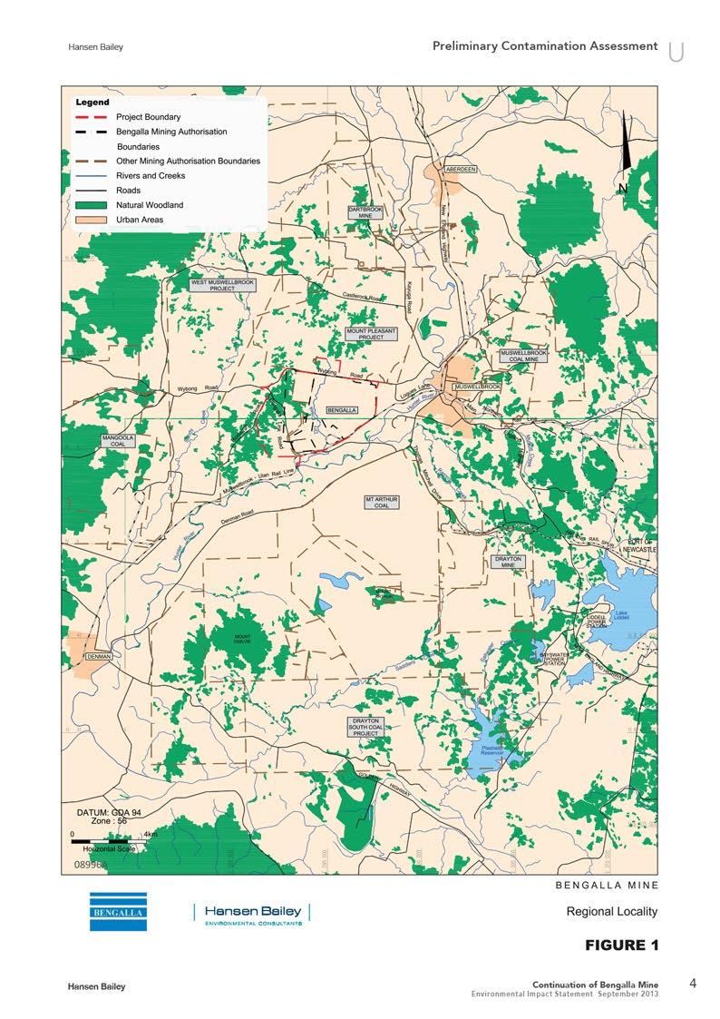
5 U CONTINUATION OF BENGALLA MINE PRELIMINARY CONTAMINATION ASSESSMENT for Bengalla Mining Company Pty Limited 1 BACKGROUND Bengalla Mining Company Pty Limited (BMC) operates the Bengalla Mine (Bengalla) in the Upper Hunter Valley of NSW. Bengalla is situated approximately 130 km north-west of Newcastle and 4 km west of the township of Muswellbrook (see Figure 1). On 7 August 1995, BMC was granted Development Consent (DA 211/93) by the then Minister for Urban Affairs and Planning. This consent authorised the construction and operation of a surface coal mine, coal preparation plant, rail loop, loading facilities and associated facilities. The application for development consent was supported by the Environmental Impact Statement for Bengalla Coal Mine (Bengalla EIS), dated November 1993 (Envirosciences, 1993). There have since been 4 approved modifications to DA 211/13. Bengalla is now approved to produce up to 10.7 Million tonnes per annum (Mtpa) of Run of Mine (ROM) coal. 1.1 THE PROJECT BMC is seeking Development Consent under Division 4.1 of Part 4 of the Environmental Planning & Assessment Act 1979 (EP&A Act) for the Project within the Project Boundary shown on Figure 2. The Project generally comprises: Open cut coal mining at up to 15 Mtpa ROM for 24 years continuing to utilise a dragline and truck / excavator fleet; Continue mining to the west of current operations; An additional Overburden Emplacement Area (OEA) to the west of Dry Creek which may be utilised for excess spoil material until it is intercepted by mining; Processing, handling and transportation of coal via the existing CHPP (to be upgraded) and rail loop for export and domestic sale; An additional CHPP stockpile and ROM coal stockpile; Continued use, expansion and upgrades to existing coal infrastructure; The construction of a radio tower; Relocation of the Explosives Magazine and Reload Facility; Relocation of a section of Bengalla Link Road near the existing mine access road to enable coal extraction; 1 Continuation of Bengalla Mine
6 U The re-diversion of Dry Creek via dams and pipe work with a later permanent realignment of Dry Creek through rehabilitation areas once stability is established; Relocation of water storage infrastructure as mining progresses through existing dams (including the staged discharge dam); The construction of raw water dams and a clean water dam; A workforce of approximately 900 full time equivalent personnel (plus contractors) at peak production; and Supporting power reticulation infrastructure. 1.2 DOCUMENT PURPOSE & OBJECTIVES The purpose of this (PCA) is to form part of the Environmental Impact Statement (EIS) being prepared by to support an application for Development Consent under Division 4.1 of Part 4 of the EP&A Act. This PCA addresses the relevant Director-General s Environmental Assessment Requirements issued for the EIS by the NSW Department of Planning and Infrastructure (DP&I) on 13 March 2012 which states that the EIS must include: a detailed assessment of the potential impacts on soils and land capability (including salinization and contamination). Further, the Environment Protection Authority s (EPA s) submission to DP&I (Attachment 1 to the DGRs) for the Project statedthe following: 1. The EIS should include an assessment of the contaminated site that is conducted in accordance with the guidelines made or approved under section 105 of the Contaminated Land Management Act 1997, for example: Guidelines for Consultants Reporting on Contaminated Sites (EPA, 2000), Guidelines for the NSW Site Auditor Scheme 2nd edition (EPA, 2006), Sampling Design Guidelines (EPA, 1995), National Environment Protection (Assessment of Site Contamination) Measure 1999 (or update). 2. The EIS should provide the details on how the site contamination will be remediated and/or managed so that the site is, or can be, made suitable for the proposed use. 3. All reports should be prepared in accordance with the Guidelines for Consultants Reporting on Contaminated Sites (EPA, 2000). 4. The EIS should specify whether or not a site auditor, accredited under the Contaminated Land Management Act 1997, has been or will be engaged to issue a site audit statement to certify on the suitability of the current or proposed uses. Continuation of Bengalla Mine 2
7 U The specific objectives of this PCA were therefore to: Identify all past and present potentially soil contaminating activities within the Project Disturbance Boundary; Identify potential contamination types; Discuss the site condition; Provide a preliminary assessment of contamination within the Disturbance Boundary; and Assess the need for further investigations by a Site Auditor accredited under the Contaminated Land Management Act DOCUMENT STRUCTURE This report contains 10 sections. This section provides background information on the Project and a description of the purpose of this PCA. The remainder of the report is structured as follows: Section 2 outlines the regulatory framework applicable to this PCA; Section 3 summarises the existing environment within the Project Boundary; Section 4 describes the methodology used for this PCA; Section 5 provides the results of a desktop study of available information; Section 6 provides a review of the historical heritage impact assessment prepared as part of the EIS for the Project; Section 7 summarises the potentially contaminated areas identified within the Disturbance Boundary; Section 8 identifies mitigation and management measures based on the results of this PCA; Section 9 outlines the limitations of this PCA; and Section 10 lists references provided throughout the PCA. 3 Continuation of Bengalla Mine
8
9
10 2 REGULATORY FRAMEWORK U 2.1 INTRODUCTION This PCA has been prepared in accordance with the regulatory framework outlined below and with reference to the following guidelines: Guidelines for Consultants Reporting on Contaminated Sites (NSW Office of Environment and Heritage, 2011); and Managing Land Contamination, Planning Guidelines, SEPP 55 Remediation of Land (NSW Department of Urban Affairs and Planning & NSW Environment Protection Authority (EPA), 1998). 2.2 ENVIRONMENTAL PLANNING AND ASSESSMENT ACT 1979 As noted in Section 1, BMC is seeking development consent for State Significant Development under Division 4.1 of Part 4 of the EP&A Act for the Project. The consent authority is the Minister for Planning & Infrastructure. The EP&A Act provides an important role in the management of land contamination in NSW by incorporating mechanisms to ensure that: Planning authorities consider contamination issues when they are making rezoning and development decisions; Local councils provide information about land contamination on planning certificates that they issue under Section 149 of the EP&A Act; and Land remediation is facilitated and controlled through State Environmental Planning Policy 55 Remediation of Land (SEPP 55). 2.3 CONTAMINATED LAND MANAGEMENT ACT 1997 The Contaminated Land Management Act 1997 (CLM Act) regulates significantly contaminated sites in NSW. The general objective of the CLM Act is to establish a process for investigating and (where appropriate) remediating land that the NSW Environment Protection Authority (EPA) considers to be contaminated significantly enough to require regulation. 2.4 STATE ENVIRONMENTAL PLANNING POLICY 55 SEPP 55 Remediation of Land (SEPP 55) was enacted to provide a state wide approach to the remediation of contaminated land for the purpose of minimising the risk of harm to the health of humans and the environment. Continuation of Bengalla Mine 6
11 U Managing Land Contamination, Planning Guidelines, SEPP 55 Remediation of Land (the Guidelines) have been prepared to assist in managing land contamination in NSW in accordance with SEPP 55. Specifically, the Guidelines provide: Information to assist in the investigation of contamination possibilities; A decision making process that responds to the information obtained from an investigation; Information on how planning and development control can cover the issues of contamination and remediation; A suggested policy approach for planning authorities; Discussion of information management systems and notification and notation schemes, including the use of section 149 planning certificate notations; and Approaches to prevent contamination and reduce the environmental impact from remediation activities. 7 Continuation of Bengalla Mine
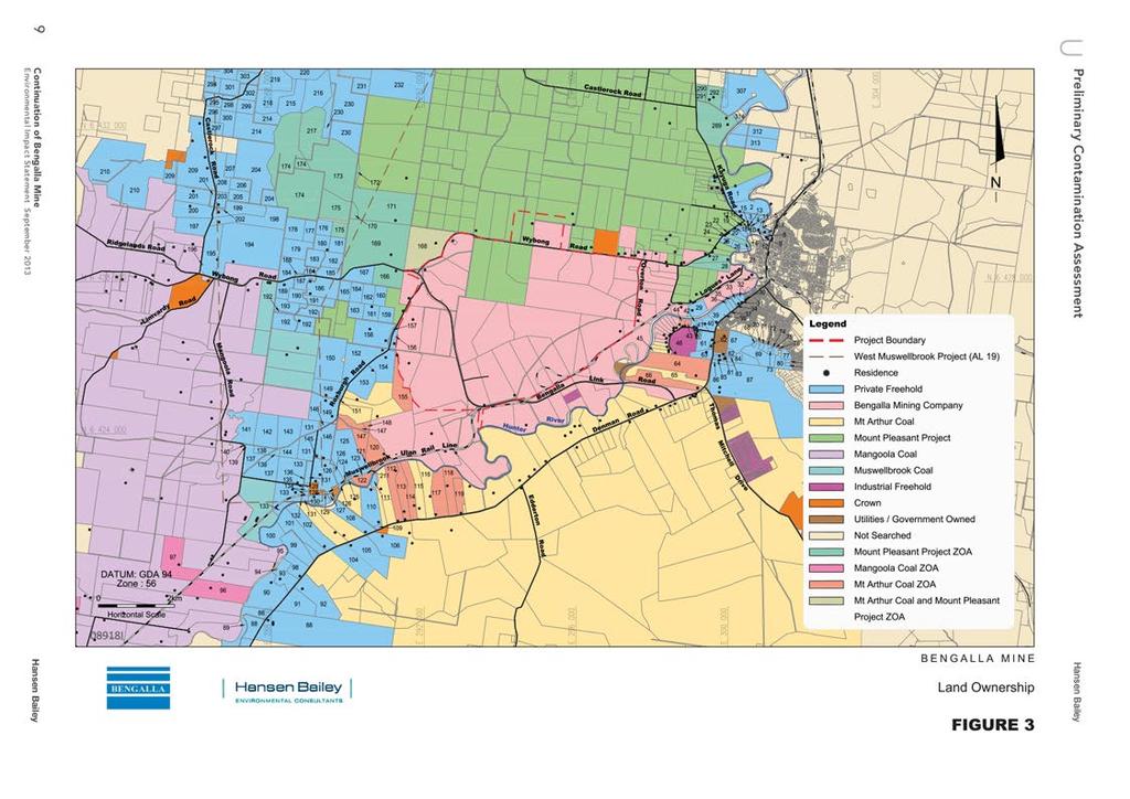
12 3.1 TOPOGRAPHY 3 EXISTING ENVIRONMENT U The land within the Project Boundary is generally undulating and slopes downwards towards the Hunter River to the south. The Hunter River alluvial flats are situated within the eastern and southern extents of the Project Boundary. In the eastern part of the Project Boundary, the Overton Ridge reaches an elevation of 188 m Australian Height Datum (AHD). To the south of the Overton Ridge are the lower hillslopes of the Hunter Valley, which range in elevation from 250 m AHD to 134 m AHD near the Hunter River (Envirosciences, 2003). The area within the Project Boundary predominantly consists of gentle gradients (less than 5 degrees). The gullies in the lower reaches of ephemeral streams draining into the Hunter River generally have slopes of less than 2.5 degrees. Ridge tops also generally have a gradient of less than 2.5 degrees. The Hunter River alluvial floodplain generally has a gradient of less than 1 degree (Envirosciences, 2003). A wide range of landscape features are present within the Project Boundary, including: Active mining areas within the approved Bengalla Mine; Completed mining areas that are awaiting or in the process of being rehabilitated; Rehabilitated areas; Bengalla Mine surface infrastructure; and Open paddock grazing land with limited stands of remnant forest and woodland. 3.2 LAND USE The Upper Hunter region has a long history of rural land use for a variety of agricultural and industrial activities, predominantly grazing and coal mining. The current dominant land uses within and adjacent to the Project Boundary include open cut coal mining and industrial activities, agriculture, rural residential and residential areas. The Hunter River is located approximately 1 km south of the Project Boundary and plays an important role in the region s mining, power generation and agricultural enterprises. 3.3 LAND OWNERSHIP Land ownership within and surrounding the Project Boundary is shown on Figure 3. All of the land within the Project Boundary is owned by BMC, with the exception of three lots owned by Coal & Allied (for the Mount Pleasant Project). Coal & Allied also owns a large area of land to the north of Bengalla. The land to the south of the Project Boundary is held by BHP Billiton for the Mt Arthur Coal Complex. Continuation of Bengalla Mine 8
13
14 U 4 METHODOLOGY To assess the history and land use of the Project Boundary, a desktop study of the following available information was undertaken, including: Review of a soil landscape map and relevant impact assessments completed for the region; Review of land ownership information for the area to identify potential contaminated sites; Review of historical aerial photos to identify historical land use and potentially contaminating activities; and Search of the register of the NSW Contaminated Sites Notified to the EPA (EPA, 2012). The findings of the desktop study are provided in Section 5. The findings of the review of the Historical Heritage Report for the Project are presented in Section 6. A summary of the areas of potential contamination identified by this PCA is provided in Section 7. Continuation of Bengalla Mine 10
15 U 5.1 REVIEW OF SOIL LANDSCAPE 5 DESKTOP STUDY The soil landscapes within the Project Boundary have been mapped during a number of previous assessments, which were reviewed for this PCA and include: Soil Landscapes of the Singleton 1:250,000 Sheet (Kovac and Lawrie, 1991); Soil Survey for the Proposed Bengalla Coal Mine (Envirosciences Pty Ltd, 1993); Bengalla Coal Mine Soil Survey Report (GSS, 2005); Soil and Land Capability Impact Assessment, Bengalla Development Consent Modification (GSSE, 2010); and Soil and Land Capability Impact Assessment, Continuation of Bengalla Mine (GSSE, 2013) prepared for the Project. The soil landscapes mapped in these assessments were reviewed for this PCA to identify any areas within the Disturbance Boundary mapped as disturbed terrain. Soils mapped in such a way indicates areas where the natural soil profile in the area is known to have been disturbed by human activities and may have been backfilled with imported filling materials. No areas of disturbed terrain were previously identified within the Disturbance Boundary in the above maps or assessments. 5.2 HISTORICAL AERIAL PHOTO REVIEW Aerial photos for the years 1953, 1964, 1972, 1982, 1993, 1998 and 2007 were investigated to identify previous land use and potentially contaminating activities throughout the Disturbance Boundary. The results of the historical aerial photo review indicate that the area within the Project Disturbance Boundary has generally been cleared since the first available aerial photos for the site were taken in Evidence of agricultural activity and infrastructure such as cropping, dairies, drainage structures and farm dams is present, with more intensive activities present in lands adjacent to the Hunter River. A number of rural residences, dairies and associated infrastructure and unsealed access roads are also present in the local area. During the period since 1953, similar agricultural activities within the Project Disturbance Boundary were seen to continue. Disturbance of some additional patches of vegetation occurred during the period from , with the more intensive activities remaining in the alluvial areas adjacent to the Hunter River. Mining activities associated with approved Bengalla Mine operations first become evident in the 1998 aerial image, with the open cut, coal stockpiles and mine infrastructure area well developed. 11 Continuation of Bengalla Mine
16 5.3 LANDOWNERSHIP INFORMATION REVIEW U To provide further information on potentially contaminated sites within the Disturbance Boundary, land ownership records and property information gathered by BMC during the preparation of the EIS for Bengalla Coal Mine (Envirosciences, 1993) were also reviewed. This review confirmed the location of residential sites and the status of agricultural activities occurring within the Disturbance Boundary. 5.4 SEARCH OF THE EPA CONTAMINATION REGISTER A review of the NSW Contaminated Sites Notified to the EPA (EPA, 2012) indicated that the land within the Project Boundary has no statutory notices issued under the provisions of the CLM Act. Continuation of Bengalla Mine 12
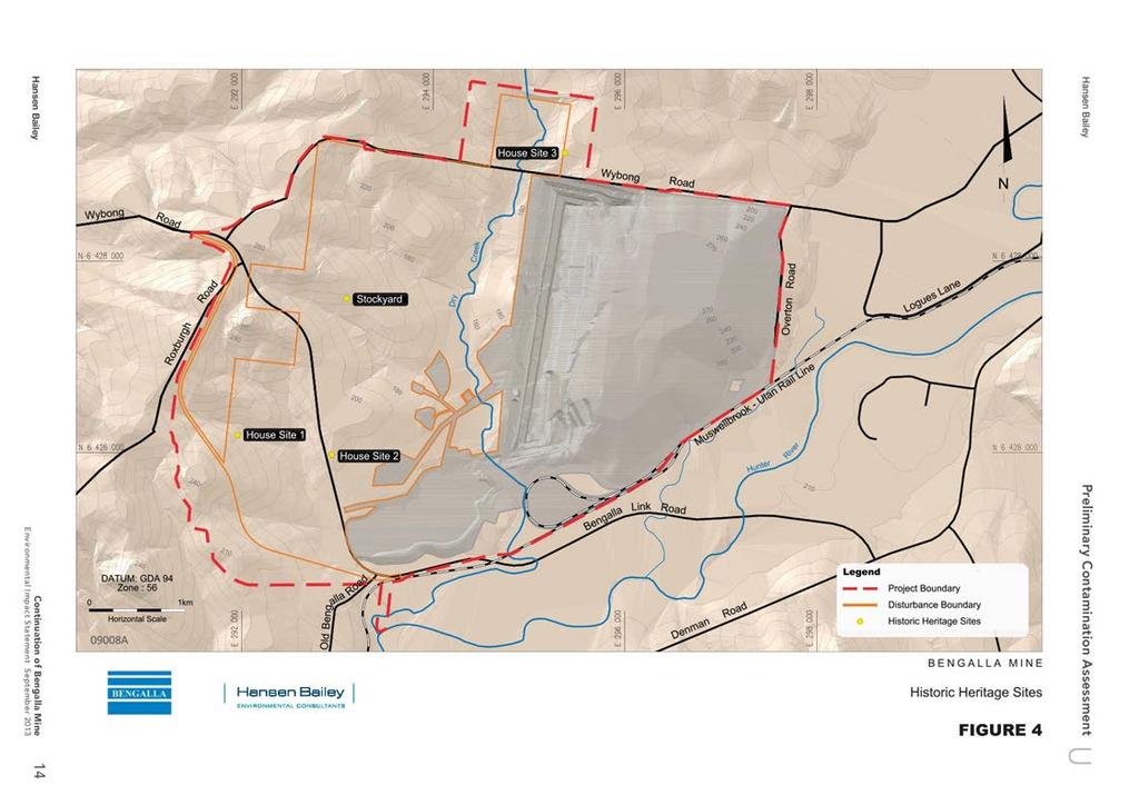
17 U 6 REVIEW OF HISTORICAL HERITAGE IMPACT ASSESSMENT As part of the Historical Heritage Impact Assessment for the Project, AECOM (2013) conducted a field survey in November and December 2011 to identify sites of heritage significance within the Project Boundary. The Historical Heritage Impact Assessment was not primarily conducted to identify areas of potential contamination and the personnel undertaking the inspections were not qualified to undertake contamination assessments. However, the results of the inspections were reviewed in order to provide additional information on potential contamination for each site identified within and adjacent to the Disturbance Boundary (see Table 1). The locations of these sites are shown in Figure 4. Table 1 Review of Historical Heritage Impact Assessment Site Name House Site 1 House Site 2 House Site 3 Stockyard Potential Sources of Contamination In-ground septic tank, above ground concrete tank and scatter of material to the north of the former house site Former house site and waste material Former house site (demolition rubble pile), dairy site, scatter of waste material to the north of the former house site Chemical use for livestock management 7 IDENTIFIED POTENTIAL CONTAMINANT SOURCES On the basis of the available site history and a review of observations presented in the Historical Heritage Impact Assessment, the principal sources of potential contamination are former residences within and adjacent to the Disturbance Boundary (see Table 1 and Figure 4). 13 Continuation of Bengalla Mine
18
19 U 8 MITIGATION AND MANAGEMENT Although potential sources of contamination were identified within the Disturbance Boundary, these were associated with structures and activities likely to be identified on other properties with a history of agricultural land uses. The results of this PCA identified the need for an additional investigation to be undertaken to assess the extent of contamination within the Disturbance Boundary. It is recommended that a contamination investigation be undertaken by a licensed contractor to further assess the extent of contamination throughout the Disturbance Boundary. This investigation should be undertaken prior to the commencement of mining in potentially contaminated areas associated with the sites of current and former rural residences. Following the detailed contamination investigation, a remedial action plan should be prepared for the Project to manage any identified contamination. Bengalla operates a bioremediation facility where any soil contaminated with hydrocarbons is placed for remediation. The bioremediation facility consists of active cells where the bioremediation process occurs. The cells are (optionally) fitted with an automated irrigation system and soil moisture probes to ensure soil conditions are suitable for beneficial bacteria and microbes to aid the remediation process. To reduce the duration of the bioremediation process, BMC adds a microbial powder to the soil to increase the hydrocarbon breakdown process and reduce the time required for treatment. Samples are regularly taken to confirm hydrocarbons levels, and when the soil meets specific land use criteria, it is appropriately placed in the Main OEA. * * * for HANSEN BAILEY Dorian Walsh Senior Environmental Scientist Dianne Munro Principal 15 Continuation of Bengalla Mine
20 U 9 LIMITATIONS This PCA was prepared by to provide a preliminary indication of contamination conditions within the Project Disturbance Boundary, based on the limited amount of available information at the time of the assessment and does not constitute a detailed site investigation undertaken by an accredited Site Auditor. A detailed site investigation should be undertaken by an accredited Site Auditor to assess the extent of contamination within the Disturbance Boundary prior to the construction phase of the Project. The information reviewed in the preparation of this report was not prepared for the purpose of a contamination assessment and therefore the observations made were not targeted towards the identification of potential contaminant sources. 10 REFERENCES AECOM Australia Pty Limited (2013). Bengalla Mine Continuation Project Environmental Impact Statement, Historical Heritage Report. Envirosciences (1993). Environmental Impact Statement of Bengalla Open Cut Coal Mine. GSS Environmental (2013). Soils and Land Capability Impact Assessment, Continuation of Bengalla Mine. Kovac, M & Lawrie, J.W (1991). Soil Landscapes of the Singleton 1:250,000 Sheet, Soil Conservation Service NSW, Sydney. NSW Department of Urban Affairs and Planning & NSW Environment Protection Authority (1998). Managing Land Contamination, Planning Guidelines, SEPP 55 Remediation of Land. NSW Environment Protection Authority (2012). List of NSW Contaminated Sites, accessed 14 June NSW Office of Environment and Heritage (2011). Guidelines for Consultants Reporting on Contaminated Sites. Continuation of Bengalla Mine 16