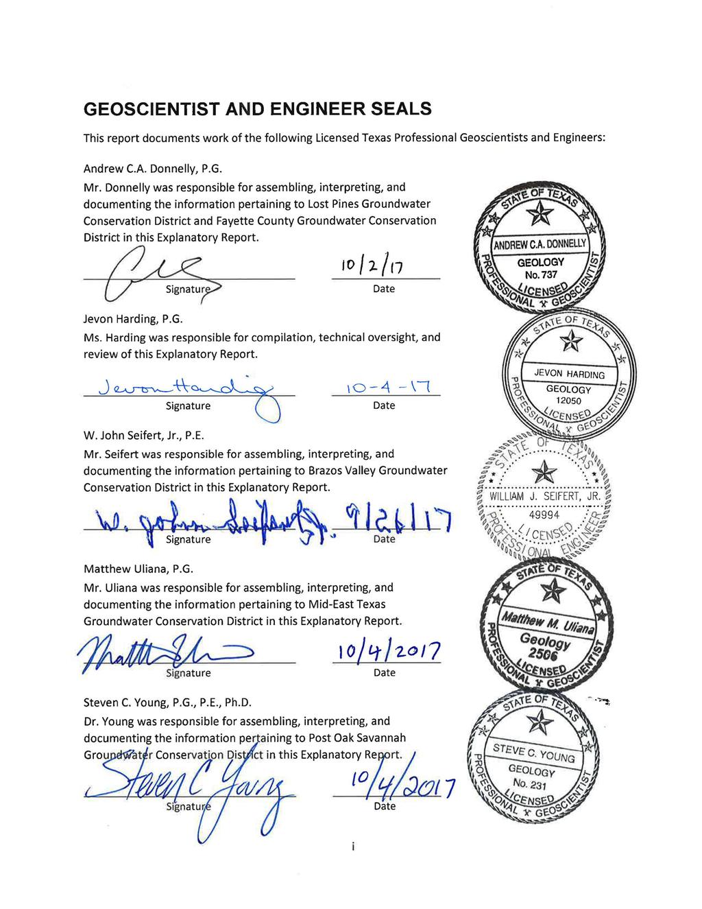
DESIRED FUTURE CONDITION EXPLANATORY REPORT FOR GROUNDWATER MANAGEMENT AREA 12
|
|
|
- Julianna Andrea Crawford
- 5 years ago
- Views:
Transcription
1 DESIRED FUTURE CONDITION EXPLANATORY REPORT FOR GROUNDWATER MANAGEMENT AREA 12 This report was considered and approved by the member districts of Groundwater Management Area 12 on September 20, Member Districts: 1. Brazos Valley Groundwater Conservation District 2. Fayette County Groundwater Conservation District 3. Lost Pines Groundwater Conservation District 4. Mid-East Texas Groundwater Conservation District 5. Post Oak Savannah Groundwater Conservation District Prepared by: Daniel B. Stephens & Associates, Austin, TX INTERA Incorporated, Austin, TX LBG-Guyton Associates, Houston, TX Matthew M. Uliana, P.G., Austin, TX October, 2017
2
3 i
4 ii
5 TABLE OF CONTENTS 1.0 INTRODUCTION GMA Joint Groundwater Planning Process GMA 12 Joint Planning GMA 12 DESIRED FUTURE CONDITIONS Sparta, Queen City, Carrizo, Calvert Bluff, Simsboro, and Hooper Aquifers Yegua-Jackson Aquifer Brazos Alluvium Aquifer Non-relevant Areas of Aquifers POLICY JUSTIFICATION TECHNICAL JUSTIFICATION Central Queen City-Sparta Groundwater Availability Model Potential Pumping Scenarios Using Queen City-Sparta GAM Yegua-Jackson GAM Potential Pumping Scenario Using Yegua-Jackson GAM Use of Groundwater Availability Models Potential Pumping of Brazos River Alluvium FACTORS CONSIDERED FOR THE DESIRED FUTURE CONDITIONS Aquifer Uses and Conditions Carrizo-Wilcox Aquifer Queen City Aquifer Sparta Aquifer Yegua-Jackson Aquifer Brazos River Alluvium Aquifer Trinity Aquifer Water Supply Needs and Water Management Strategies Hydrological Conditions Geology and Hydrogeology Total Estimated Recoverable Storage (TERS) Average Annual Recharge, Inflows, and Discharge Environmental Factors Subsidence Socioeconomics Regional Planning Assessment of Socioeconomic Impact Other Considerations of Socioeconomic Impacts Socioeconomic Considerations in GMA Impacts of Major and Minor Aquifer DFCs on Socioeconomic Impacts Reasonably Expected to Occur Private Property Rights Feasibility of Achieving the Proposed Desired Future Condition Any Other Relevant Information OTHER DESIRED FUTURE CONDITIONS CONSIDERED RECOMMENDATIONS AND COMMENTS RECEIVED iii
6 7.1 Comments Received by Brazos Valley GCD Comments Received by Fayette County GCD Comments Received by Lost Pines GCD Comments Received by Mid-East Texas GCD Comments Received by Post Oak Savannah GCD SUMMARY Summary of DFCs Rationale and Justification for DFC Selection REFERENCES Appendix A Agendas and Minutes for GMA 12 Joint Groundwater Planning Meetings from 2012 to 2017 Appendix B GMA-12 Resolution for Proposed DFCs Dated April 15, 2016 Appendix C Notices of and Minutes for GCD Public Hearings on Proposed GMA 12 DFCs Appendix D Documentation of GMA 12 Boundary Amendment in Brazos Valley GCD Appendix E September 20, 2017 Presentation "GMA 12 TWDB Clarifications and Assumptions Update" Appendix F May 28, 2015 Presentation "GMA 12 Aquifer uses and Conditions Consideration Discussion" Appendix G June 25, 2015 Presentation "GMA 12 Needs and Strategies" Appendix H TERS for GMA 12 (GAM Task ) Appendix I GAM Run for Fayette County GCD Appendix J GAM Run for Lost Pines GCD Appendix K GAM Run for Post Oak Savannah GCD Appendix L GAM Run for Brazos Valley GCD Appendix M GAM Run for Mid-East Texas GCD Appendix N May 28, 2015 Presentation "GMA 12 Hydrological Conditions Consideration Discussion" Appendix O August 13, 2015 Presentation "GMA-12 Environmental Impact Considerations" Appendix P August 13, 2015 Presentation "GMA 12 Socioeconomic Impacts Considerations" Appendix Q June 25, 2015 Presentation "Groundwater Management Area 12 Consideration of the Impact on the Interests and Rights in Private Property in the Adoption of Desired Future Conditions of Aquifers" Appendix R August 13, 2015 Presentation to GMA-12 Feasibility of a DFC Appendix S GMA 12's Responses to Comments for Brazos Valley GCD Appendix T GMA 12's Responses to Comments for Lost Pines GCD Appendix U GMA 12's Responses to Comments for Post Oak Savannah GCD Appendix V GMA 12's Responses to Texas Water Development Board Clarifications and Assumptions Request iv
7 LIST OF FIGURES Figure 1-1 Groundwater Management Areas in Texas... 7 Figure 1-2 Groundwater Conservation Districts in GMA Figure 1-3 Major Aquifers in GMA Figure 1-4 Minor Aquifers in GMA Figure 4-1 Conceptual Flow Model of the Sparta, Queen City, and Carrizo-Wilcox Aquifers (from Kelley and others, 2004, Figure 5.1) Figure 4-2 Yegua-Jackson Aquifer System and Location (from Deeds and others, 2010, Figure 2.2.4) Figure 4-3 Conceptual Flow Model of the Yegua-Jackson Aquifer (from Deeds and others, 2010, Figure 5.0.1) Figure 5-1 Surface geology of GMA Figure 5-2 Extent of Carrizo-Wilcox Aquifer within GMA Figure 5-3 Extent of Carrizo Aquifer within GMA Figure 5-4 Extent of Calvert Bluff Aquifer within GMA Figure 5-5 Extent of Simsboro Aquifer within GMA Figure 5-6 Extent of Hooper Aquifer within GMA Figure 5-7 Extent of Queen City Aquifer within GMA Figure 5-8 Extent of Sparta Aquifer within GMA Figure 5-9 Extent of Yegua-Jackson Aquifer within GMA Figure 5-10 Extent of Brazos River Alluvium Aquifer within GMA Figure 5-11 Generic cross-section of the Carrizo-Wilcox Aquifer in GMA 12 (modified from Ashworth and Hopkins, 1995) Figure 5-12 Socioeconomic Impacts Analysis 2011 Brazos G Regional Water Plan Lost Income by Sector ($millions) Figure 5-13 Social Impacts of Water Shortages in Region G LIST OF TABLES Table 1-1 A simplified stratigraphic column for GMA Table 1-2 Population projection from the 2017 State Water Plan... 4 Table 1-3 GMA 12 meetings convened from 2012 to Table 1-4 Public hearings conducted by the GCDs regarding the proposed DFCs Table 2-1 Adopted DFCs for the Sparta, Queen City, Carrizo, Calvert Bluff, Simsboro, and Hooper Aquifers Table 2-2 Adopted DFCs for the Yegua and Jackson Aquifers Table 2-3 Adopted DFCs for the Brazos River Alluvium Aquifer Table 4-1 Average Aquifer Drawdown calculated for Sparta, Queen City, Carrizo, Calvert Bluff, Simsboro, and Hooper Aquifers using PS Table 4-2 Average Aquifer Drawdown calculated for Yegua-Jackson Aquifer using YGJK-PS Table 5-1 Estimated historic overall water use met with groundwater Table metered/reported groundwater production in acre-feet Table 5-3 Total estimated groundwater production from the Carrizo-Wilcox Aquifer in v
8 Table 5-4 Total estimated groundwater production from the Queen City Aquifer in Table 5-5 Total estimated groundwater production from the Sparta Aquifer in Table 5-6 Total estimated groundwater production from the Yegua-Jackson Aquifer in 2013 in acre-feet Table 5-7 Total estimated groundwater production from the Brazos River Alluvium Aquifer in 2013 in acre-feet Table State Water Plan Amounts for Supplies, Demands and Strategies for the 14 Counties that Comprise GMA Table State Water Plan Amounts for Supplies, Demands and Strategies for the Five GCDs that a part of GMA Table 5-10 Total estimated recoverable storage (TERS) in the Carrizo-Wilcox Aquifer in Fayette County Table 5-11 Total amount of groundwater in storage (TERS) (in acre-feet) in GMA Table 7-1 Summary of all comments received by GMA 12 on the proposed DFCs Table 8-1 Adopted DFCs for the Sparta, Queen City, Carrizo, Calvert Bluff, Simsboro, and Hooper Aquifers Table 8-2 Adopted DFCs for the Yegua-Jackson Aquifer Table 8-3 Adopted DFCs for the Brazos River Alluvium Aquifer vi
9 ACRONYMS AND ABBREVIATIONS ac-ft/yr DBSA DFCs GAM GCD GMA gpm HB INTERA IO models LBG-Guyton MAG mg/l PS RWPG SAM TDS TERS TWDB WSC acre-feet per year Daniel B. Stephens & Associates Desire Future Conditions Groundwater Availability Model Groundwater Conservation District Groundwater Management Area gallons per minute House Bill INTERA Incorporated input/output models LBG-Guyton Associates modeled available groundwater milligrams per liter potential scenarios regional water planning group social accounting matrix total dissolved solids total estimated recoverable storage Texas Water Development Board Water Supply Corporation vii
10 This page is intentionally blank. viii
11 1.0 INTRODUCTION 1.1 GMA 12 Groundwater Management Areas (GMAs) were created in order to provide for the conservation, preservation, protection, recharging, and prevention of waste of the groundwater, and of groundwater reservoirs or their subdivisions, and to control subsidence caused by withdrawal of water from those groundwater reservoirs or their subdivisions, consistent with the objectives of Section 59, Article XVI, Texas Constitution (Texas Water Code ). The responsibility for GMA delineation was delegated to the Texas Water Development Board (TWDB) (Section , Chapter 35, Title 2, Texas Water Code). The initial GMA delineations were adopted on December 15, 2002, and are modified as necessary according to agency rules. There are 16 GMAs in Texas. Figure 1-1 shows the boundaries of these 16 GMAs, including GMA 12. GMAs consist of all Groundwater Conservation Districts (GCDs) located within the GMA boundary. Figure 1-2 shows the location of the five GCDs that are contained wholly or in part within the boundary of GMA 12: Brazos Valley GCD, Fayette County GCD, Lost Pines GCD, Mid-East Texas GCD and Post Oak Savannah GCD. The GMA area may also include counties that are not included in a GCD. GMA 12 includes portions of four counties that are not associated with GCDs: Falls, Limestone, Navarro and Williamson counties. Portions of three major aquifers, as defined by TWDB, fall within GMA 12: the Gulf Coast Aquifer, the Carrizo-Wilcox Aquifer and the Trinity Aquifer. Figure 1-3 shows the outlines of the major aquifers within GMA 12. The Carrizo-Wilcox Aquifer is, by far, the most extensive and important aquifer in the region, occurring in all five GCDs and providing significant quantities of groundwater across the GMA. The other two major aquifers that occur within GMA 12 only occur in a very limited area within the GMA: the Gulf Coast Aquifer only outcrops in a very small area in the southernmost portion of Brazos County, along the southeast boundary of GMA 12, and the Trinity Aquifer subcrop only exists in a small area along the northwest GMA 12 boundary in Bastrop, Lee and Williamson counties. In addition to these major aquifers, portions of four minor aquifers, as defined by TWDB, are also present within GMA 12: the Brazos River Alluvium Aquifer, the Queen City Aquifer, the Sparta Aquifer, and the Yegua-Jackson Aquifer. Figure 1-4 shows the outlines of the minor aquifers within GMA 12. All minor aquifers are used as water supply sources within GMA 12. Table 1-1 is a stratigraphic column showing the relative ages of the aquifers. With the exception of the Brazos River Alluvium Aquifer, which is heavily pumped for irrigation purposes, most of the groundwater pumped in GMA 12 is from the Carrizo-Wilcox Aquifer. In this report, the Carrizo-Wilcox Aquifer will be subdivided into four major hydrogeologic units, from youngest to oldest: the Carrizo Aquifer, the Calvert Bluff Aquifer (Upper Wilcox Aquifer), the Simsboro Aquifer (Middle Wilcox Aquifer), and the Hooper Aquifer (Lower Wilcox Aquifer), as shown in Table 1-1. GMA 12 includes all or part of 14 Texas counties: Bastrop, Brazos, Burleson, Falls, Fayette, Freestone, Lee, Leon, Limestone, Madison, Milam, Navarro, Robertson, and Williamson counties. Table 1-2 lists the fourteen counties and their area and population projections. As of the 2010 Census, these counties had a population of about 930,700 that is projected to grow to almost 3 million by Most of this growth will occur in Williamson County, of which only a small portion falls within the GMA 12 boundary. 1
12 However, even excluding Williamson County, the population of GMA 12 is expected to more than double by 2070, and this growing population and the accompanying water demand could have significant implications for groundwater resources GMA 12. After Williamson County, the most populated and fastest growing counties are Bastrop County, whose population values include fastgrowing suburbs of Austin, and Brazos County, which contains the fast-growing Bryan/College Station area. 1.2 Joint Groundwater Planning Process The joint groundwater planning process was first adopted by the Texas Legislature with the passage of House Bill (HB) 1763 in One of the requirements of HB 1763 is that, where two or more GCDs are located within the same boundaries of a GMA, the GCDs shall establish Desire Future Conditions (DFCs) for all relevant aquifers in the GMA by no later than September 1, 2010 and every five years thereafter. DFCs are defined in Title 31, Part 10, (6) of the Texas Administrative Code as the desired, quantified condition of groundwater resources (such as water levels, spring flows, or volumes) within a management area at one or more specified future times as defined by participating groundwater conservation districts within a groundwater management area as part of the joint planning process. Once DFCs are adopted, the Executive Administrator of the TWDB calculates the modeled available groundwater (MAG) for the aquifers, which is the estimated amount of pumping that will achieve the DFC. DFCs are essentially planning goals that could be reached, but should not be exceeded. The joint groundwater planning horizon extends through at least the end of the current regional water planning period pursuant to , Texas Water Code, or in perpetuity, as defined by participating GCDs within a GMA as part of the joint groundwater planning process. The joint groundwater planning process was expanded significantly by the passage of Senate Bill 660 in The more substantive elements of the expanded process include: (1) new requirements that an Explanatory Report be developed and submitted as part of the joint groundwater planning process to document that required factors have been considered; (2) a change from requirements involving estimates of managed available groundwater to modeled available groundwater (MAG) (including the process for addressing exempt use); (3) new requirements for individual GCDs to provide for a 90-day public comment period, during which the individual GCD is to hold a public hearing on the proposed DFCs before final adoption by at least two thirds of the GCD representatives in the GMA; and (4) as soon as possible after final adoption of the DFCs by GCD representatives in the GMA, individual GCDs are to adopt the DFCs. The deadline for adopting proposed DFCs for the second round of joint groundwater planning was extended to May 1, 2016, by the passage of Senate Bill 1282 by the Texas Legislature in If a GMA includes more than one GCD, those districts must engage in a joint groundwater planning process, including at least an annual meeting. The districts must jointly determine the DFCs for the management area and, in doing so, are required to consider the nine following factors: 1. Aquifer uses or conditions within the management area, including conditions that differ substantially from one geographic are to another; 2. The water supply needs and water management strategies included in the state water plan; 2
13 3. Hydrological conditions, including for each aquifer in the management area the total estimated recoverable storage as provided by the executive administrator, and the average annual recharge, inflows, and discharge; 4. Other environmental impacts, including impacts on spring flow and other interactions between groundwater and surface water; 5. The impact on subsidence; 6. Socioeconomic impacts reasonably expected to occur; 7. The impact on the interests and rights in private property, including ownership and the rights of management area landowners and their lessees; 8. The feasibility of achieving the DFC; and 9. Any other information relevant to the specific DFCs. After the DFCs are adopted by a GMA, the TWDB determines a MAG value based on the adopted DFCs. A MAG is defined in Title 31, Part 10, (13) of the Texas Administrative Code as the amount of water that the executive administrator determines may be produced on an average annual basis to achieve a desired future condition. 1.3 GMA 12 Joint Planning The joint groundwater planning process established by HB 1763 in 2005 and amended by Senate Bill 660 in 2011 is a public, transparent process, where all planning decisions are made in open, publicly noticed meetings in accordance with provisions contained in Texas Water Code Chapter 36. From 2012 to 2017, GMA 12 convened 23 times at the dates listed in Table 1-3. All of the meetings were open to the public and were held at the Milano Civic Center in Milano, Texas. All meeting notices were posted at least 10 days in advance of the meeting and included an invitation to submit comments, questions and requests for additional information to the Post Oak Savannah GCD. Table 1-3 lists the dates and the major discussion topics of the GMA 12 joint planning meetings from 2012 to Appendix A contains the agenda and the minutes for all of the GMA 12 meetings. The GCDs that are members of GMA 12 retain hydrogeologic consultants for GCD-level management and modeling. INTERA Incorporated (INTERA) serves as the consultant for Post Oak Savannah GCD, Daniel B. Stephens & Associates (DBSA) serves as the consultant for Lost Pines GCD and Fayette County GCD, LBG- Guyton Associates (LBG-Guyton) serves as the consultant for Brazos Valley GCD and Matthew M. Uliana, P.G. serves as the consultant for Mid-East Texas GCD. This Explanatory Report is a joint effort of these four consulting firms. During the GMA 12 meeting on April 15, 2016, GMA 12 proposed the DFCs for adoption. As required by Texas Water Code Section (d-2), the proposed DFCs were subsequently distributed to the individual GCDs in GMA 12. A copy of the resolution for proposed DFCs is included as Appendix B. A period of not less than 90 days was provided by each GCD to allow for public comments on the proposed DFCs. During this comment period, each GCD held a public hearing on the proposed DFCs. Table 1-4 lists the date on which each GCD conducted a public hearing on the proposed DFCs. Minutes for these public hearings are included in Appendix C. 3
14 Table 1-1 A simplified stratigraphic column for GMA 12 System Series Geologic Unit Hydrogeologic Unit Quaternary Brazos River Alluvium Brazos River Alluvium Aquifer Upper Eocene Middle Eocene Tertiary Lower Eocene Upper Paleocene Jackson Group Yegua Formation Yegua-Jackson Aquifer Cook Mountain Formation confining unit Sparta Sand Sparta Aquifer Weches Formation confining unit Queen City Sand Queen City Aquifer Reklaw Formation confining unit Carrizo Sand Calvert Bluff Fm. (Upper Wilcox) Carrizo- Wilcox Aquifer Simsboro Fm. (Middle Wilcox) Hooper Fm. (Lower Wilcox) Table 1-2 Population projection from the 2017 State Water Plan Name Area 1 (square miles) Population Population 2020 Population 2030 Population 2040 Population 2050 Population 2060 Population 2070 Bastrop ,171 95, , , , , ,244 Brazos , , , , , , ,529 Burleson ,187 18,539 19,946 20,838 21,735 22,442 23,022 Falls ,866 19,413 20,397 20,610 20,126 20,736 21,364 Fayette ,554 28,373 32,384 35,108 37,351 39,119 40,476 Freestone ,816 20,437 21,077 22,947 31,142 44,475 73,287 Lee ,612 19,131 21,511 22,877 23,375 23,709 23,889 Leon 1,081 16,801 18,211 19,536 20,603 22,071 23,340 24,582 Limestone ,384 25,136 26,615 27,817 29,134 30,206 31,152 Madison ,664 14,753 15,817 16,786 17,872 18,886 19,877 Milam 1,022 24,757 26,234 27,793 28,896 30,300 31,501 32,629 Navarro 1,086 47,735 52,544 57,032 61,667 71,452 86, ,814 Robertson ,622 18,358 20,150 21,801 23,525 25,174 26,771 Williamson 1, , , , ,495 1,195,374 1,431,101 1,675,901 TOTAL 930,699 1,216,703 1,466,960 1,755,090 2,090,959 2,486,916 2,940,537 1 calculated from the Stratmap county shapefile from TNRIS 2 from the 2010 Census 4
15 Table 1-3 GMA 12 meetings convened from 2012 to 2017 Meeting Date October 18, 2012 July 25, 2013 December 19, 2013 Quorum Present Yes Yes Yes Major Discussion Topic Appointed representatives to regional water planning groups, discussed TWDB MAG runs and proposed improvements to Queen City-Sparta (Central Carrizo) GAM, GCD reports on status of Management Plans GCD updates on joint planning and anticipated changes to DFCs, discussion of new DFC adoption process (Water Code Chapter ), discussed proposed improvements to Queen City-Sparta (Central Carrizo) GAM Discussed joint planning requirements and GCD consultants roles, GCD updates on Management Plans and monitoring, began process to update Queen City-Sparta (Central Carrizo) GAM June 6, 2014 Yes Discussed pumping and projected groundwater demand used in GAMs, discussion of costs and strategy for extending the calibration period for the Queen City-Sparta (Central Carrizo) GAM June 27, 2014 Yes Accepted a standardized form for written comments, discussion of process and schedule for proposing DFCs, discussed shallow management zone DFCs and drawdown-based DFCs, received public comments concerning groundwater/surface water interactions and private property rights. December 4, 2014 Yes Presentations on preliminary modeling results, updated pumping files for the Queen City-Sparta (Central Carrizo) GAM, shallow zone management strategies, and Total Estimated Recoverable Storage in GMA 12. February 26, 2015 Yes Discussed DFCs for shallow management zones, presentation of GAM results up to predictive scenario 4 (PS4), PS4 submitted for public comment March 27, 2015 Yes Received comments on PS4 & DFC options April 30, 2015 Yes Discussed GAM results up to predictive scenario 4 (PS4) and comments received on PS4, accepted a standardized form for GCDs to submit proposed DFCs. May 28, 2015 Yes Presentations on Hydrologic Conditions* and Aquifer Uses and Conditions* June 25, 2015 Yes Presentations on Private Property Rights* and Water Supply Needs and Water Management Strategies* August 13, 2015 Yes Presentations on 1) Environmental Impacts*, 2) Socioeconomic Impacts* and 3) DFC Feasibility* September 24, 2015 Yes Presentation on Subsidence* and discussion of the previous presentations on 1) Aquifer Uses and Conditions*, 2) Water Supply Needs and Water Management Strategies*, 3) Private Property Rights*, including comments received on these topics October 22, 2015 Yes Presentation on Feasibility of DFCs*, discussion of previous presentations on 1) Socioeconomic Impacts*, 2) Environmental Impacts*, and 3) Hydrological Conditions including comments received on these topics. December 17, 2015 Yes Presentation on GAM results for Predictive Scenario 5 (PS5), TWDB presentation on role of GAMs in joint planning, discussion of previous presentation on Feasibility of DFCs* as well as comments received on that topic. February 4, 2016 Yes Updated pumping files used for groundwater modeling, presentation on Brazos 5
16 Meeting Date Quorum Present Major Discussion Topic River alluvium DFCs, receive public comments on impact of DFCs on GW/SW interaction March 24, 2016 Yes Presentation of GAM results for a modified Predictive Scenario 5 (PS5) April 15, 2016 Yes Proposed GMA 12 DFCs approved and released for public comment October 11, 2016 December 1, 2016 Yes Yes Presentation on GAM results for Predictive Scenario 10 (PS10), discussion of comments received on GMA 12 DFCs. Discussed and accepted submission of Predictive Scenario 10 (PS10) in lieu of Predictive Scenario 6 (PS6) for purposes of evaluation of proposed DFCs. April 27, 2017 Yes Discussed draft of Explanatory Report for GMA 12 DFCs May 25, 2017 Yes Adoption of GMA 12 DFCs and Explanatory Report September 20, 2017 Yes Adoption of updated GMA 12 DFC Resolution and Explanatory Report (with PS12 pumping) * Denotes the nine factors required during considerations for DFCs under Texas Water Code Section Table 1-4 Public hearings conducted by the GCDs regarding the proposed DFCs. GCD Public Hearing Date Brazos Valley GCD May 12 & June 9, 2016 Fayette County GCD July 11, 2016 Lost Pines GCD July 20, 2016 Mid-East Texas GCD June 28, 2016 Post Oak Savannah GCD July 12,
17 Figure 1-1 Groundwater Management Areas in Texas 7

18 Figure 1-2 Groundwater Conservation Districts in GMA 12 8
19 Figure 1-3 Major Aquifers in GMA 12 9

20 Figure 1-4 Minor Aquifers in GMA 12 10
21 2.0 GMA 12 DESIRED FUTURE CONDITIONS 2.1 Sparta, Queen City, Carrizo, Calvert Bluff, Simsboro, and Hooper Aquifers The Sparta, Queen City, and Carrizo aquifers are present and used in all GCDs within GMA 12. Therefore, all GCDs submitted DFCs for these aquifers. The Calvert Bluff, Simsboro, and Hooper aquifers are present in all GCDs but not used in Fayette County. Therefore, GMA 12 declared these aquifers not relevant for Fayette County, and Fayette County GCD did not submit a DFC for these aquifers. For the purpose of establishing DFCs, the Groundwater Availability Model (GAM) for the Queen City and Sparta Aquifers (Kelley and others, 2004) was used to determine the compatibility and physical possibility of the DFCs proposed by each GCD. Note that this GAM also includes the Carrizo-Wilcox Aquifer. The DFCs proposed by each GCD for these six aquifers are provided in Table 2-1, as well as the DFC adopted by GMA 12 as a whole. The DFC is based on the average drawdown from January 2000 through December Table 2-1 Adopted DFCs for the Sparta, Queen City, Carrizo, Calvert Bluff, Simsboro, and Hooper Aquifers Average Aquifer Drawdown (ft) measured from GCD or County January 2000 through December 2069 Sparta Queen City Carrizo Calvert Bluff Simsboro Hooper Brazos Valley GCD Fayette County GCD Declared as non-relevant Lost Pines GCD Mid-East Texas GCD Post Oak Savannah GCD Falls County Limestone County Navarro County Williamson County GMA Yegua-Jackson Aquifer The Yegua-Jackson Aquifer is present in all GCDs in GMA 12. All GCDs except Brazos Valley GCD manage the Yegua-Jackson Aquifer as a single unit. Consequently, the Brazos Valley GCD adopted two DFCs for the Yegua-Jackson Aquifer: a DFC for the Jackson Aquifer and separate DFC for the Yegua Aquifer. The DFCs proposed by each GCD for the Yegua-Jackson Aquifer are provided in Table 2-2, as well as the DFC adopted by GMA 12 as a whole. Lost Pines GCD did not propose a DFC because the district has declared the Yegua-Jackson Aquifer as a non-relevant aquifer. For the purpose of establishing and evaluating DFCs, the GAM for the Yegua-Jackson Aquifer (Deeds and others, 2010) was used to determine the compatibility and physical possibility of the DFCs submitted by each GCD. The DFC is based on the average drawdown from January 2010 through December
22 Table 2-2 Adopted DFCs for the Yegua and Jackson Aquifers GCD Average Aquifer Drawdown (ft) measured from January 2010 through December 2069 Yegua Jackson Yegua-Jackson Brazos Valley GCD Fayette County GCD Lost Pines GCD Mid-East Texas GCD Post Oak Savannah GCD GMA Brazos Alluvium Aquifer In GMA 12, the Brazos River Alluvium Aquifer is only present in Post Oak Savannah GCD and the Brazos Valley GCD. For this reason, GMA 12 adopted DFCs at a county level in these two GCDs, as shown in Table 2-3. DFCs for the Brazos River Alluvium Aquifer were not adopted for GMA 12 as a whole. Table 2-3 Adopted DFCs for the Brazos River Alluvium Aquifer Brazos Valley GCD County Brazos River Alluvium Aquifer Post Oak Savannah Brazos & Robertson Burleson Milam 2.4 Non-relevant Areas of Aquifers North of State Highway 21: Percent saturation shall average at least 30% of total well depth. South of State Highway 21: Percent saturation shall average at least 40% of total well depth. A decrease in 6 feet in the average saturated thickness over the period from 2010 to A decrease of 5 feet in average saturated thickness over the period from 2010 to 2070 There are four areas where aquifers were declared non-relevant during the current cycle of joint groundwater planning. The Trinity Aquifer was declared non-relevant in Bastrop, Lee and Williamson counties because of its small areal coverage, great depth and poor water quality. The Yegua-Jackson Aquifer was declared non-relevant in Lost Pines GCD because it has a minimal amount of pumpage within the district. The Wilcox portion of the Carrizo-Wilcox Aquifer was declared non-relevant in Fayette County GCD because of the poor water quality and the great depth to these units. The Gulf Coast aquifer was declared non-relevant in Brazos Valley GCD because it is thin, can only provide water in small quantities and is very limited in areal extent. It should be noted that this small outcrop of Gulf Coast Aquifer in the southernmost part of Brazos County was included in GMA 12 as a result of a 2013 amendment to the boundaries of GMA 12 and 14. The supporting documents for this administrative change are included in Appendix D. 12
23 3.0 POLICY JUSTIFICATION The adoption of DFCs by GCDs, pursuant to the requirements and procedures set forth in Texas Water Code Chapter 36, is an important policy-making function. DFCs are planning goals that state a desired condition of the groundwater resources in the future in order to promote better long-term management of those resources. GCDs are authorized to utilize different approaches in developing and adopting DFCs based on local conditions and the consideration of other statutory criteria as set forth in Texas Water Code Section GMA 12 and each of its member districts evaluated DFCs with regard to the nine factors required by Texas Water Code Section (d). In addition to these nine factors, GMA 12 and the individual districts evaluated DFCs with regard to providing a balance between the highest practicable level of groundwater production and the conservation, preservation, protection and recharging, and prevention of waste of groundwater in GMA 12. While much of this process was guided by scientific analysis including groundwater availability models, the actual creation of DFCs requires a blending of both science and policy. Policy is able to take into account the limitations and uncertainty inherent in groundwater availability models, and provide guidance for and define the bounds of what these scientific tools can reasonably be expected to accomplish. In evaluating the DFCs, GMA 12 and the individual districts recognize that: (1) the production capability of the aquifers varies significantly across GMA 12, (2) historical groundwater production is significantly different across GMA 12, and (3) the importance of groundwater production to the social-economic livelihood of an area is significantly varied among the districts. As a result of this recognition, a key GMA 12 policy decision was to allow districts to set different DFCs for the portion of an aquifer within their boundaries, as long as the different DFCs could be shown to be physically possible. The allowance of different DFCs among the districts is justified for several reasons. First, the Texas Water Code Section (d)(1) authorizes the adoption of different DFCs for different geographic areas over the same aquifer based on the boundaries of political subdivisions. The statute expressly and specifically directs GCDs to consider uses or conditions of an aquifer within the management area, including conditions that differ substantially from one geographic area to another when developing and adopting DFCs for: 1. each aquifer, subdivision of an aquifer, or geologic strata located in whole or in part within the boundaries of the management area; or 2. each geographic area overlying an aquifer in whole or in part or subdivision of an aquifer within the boundaries of the management area. The Legislature s addition of the phrase in whole or in part makes it clear that GCDs may establish a different DFC for a geographic area that does not cover the entire aquifer but only part of that aquifer. Moreover, the plain meaning of the term geographic area in this context would include an area defined by political boundaries, such as those of a GCD or a county. Secondly, GMA 12 is composed of several different GCDs, each of which manages a separate portion of the aquifer. By statute, GCDs cannot regulate outside of their district boundary, and the rules that they pass in order to regulate the management of groundwater only apply within their boundaries. Therefore, GMA 12 recognized that separate DFCs had to be defined for each GCD within the GMA. Each GMA 12 GCD compiled all relevant comments received during the 90-day public comment period regarding the proposed DFCs and suggested revisions to the proposed DFCs and the basis for the 13
24 revisions. The comments received and the GMA s responses to them are summarized in Section 7 and provided in Appendices S through V. Based on public comments, District Representatives of GMA 12 considered and approved limited changes to the proposed DFCs. The DFCs that GMA 12 considered and proposed for final adoption, inclusive of all non-substantive changes, provided acceptable drawdown levels in the various aquifers on a county-by county basis and across the entire GMA 12 area. 14
25 4.0 TECHNICAL JUSTIFICATION 4.1 Central Queen City-Sparta Groundwater Availability Model The proposed DFCs for the Sparta, Queen City, Calvert, Simsboro and Hooper aquifers were developed based on simulations of potential scenarios (PS) of future pumping using the groundwater availability model for the Central Queen City-Sparta/Carrizo-Wilcox Aquifers (Kelley and others, 2004). This GAM supersedes the GAM of the Central Carrizo-Wilcox Aquifer (Dutton and others, 2003) as it added the Sparta and Queen City aquifers to the original GAM. The GAM used in the current cycle of joint groundwater planning was calibrated for the time period from 1975 to 1989, and the verification period was from 1990 to The report for the GAM states that it provides an integrated tool for the assessment of water management strategies to directly benefit state planners, regional water planning groups and groundwater conservation districts. In addition, the model documentation states that based the resolution of the 1-mile by 1-mile grid cells that comprise the model grid, the GAM is not capable of accurate predictions of aquifer responses at specific points such as a particular well. The documentation also states that the GAM is accurate at a scale of tens of miles, which is adequate to understand groundwater availability at the regional scale (Kelley and others, 2004). In summary, the model is a regional tool that was developed for utilization in water resources planning. The GAM is currently being updated and revised by the TWDB and the results of that effort should be available in the next two to three years. The current GAM simulates groundwater flow in as the eight model layers shown on Figure 4-1. The model simulates varying degrees of vertical interaction between aquifers, which can result in pumping effects in a particular aquifer spreading to the aquifers above or below. The magnitude of this effect will vary substantially based on the aquifer hydraulic parameters assigned to aquifers in the GAM. A conceptual block diagram of flow in the GAM is shown on Figure 4-1. As with all models, there are limitations to the current GAM, but it is the best tool available for estimating the effects of pumping the relevant aquifers in GMA 12. Several different potential pumping scenarios were developed and considered by GMA 12 in 2015, 2016, and These pumping scenarios helped GMA 12 evaluate the predicted impact that varying amounts of pumpage would have on future water levels across the GMA. 4.2 Potential Pumping Scenarios Using Queen City-Sparta GAM Modeling simulations were performed for the period from 2000 to 2070 utilizing the GAM. Because the GAM calibration/verification ended in 1999, the simulations started where the calibrated model ended and continued through the planning period defined by the TWDB guidelines. As part of the GMA 12 planning effort, the well file for pumping from the Sparta, Queen City, Carrizo, Calvert Bluff, Simsboro and Hooper aquifers in the Brazos Valley GCD, Lost Pines GCD and Mid-East Texas GCD was updated for 2000 through This update included amounts and areal distribution of pumping from the aquifers modeled with the GAM. A number of potential scenarios (PSs) were developed for consideration by the GMA. Some scenarios evaluated the impact that the full production of existing permits would have on future water levels, while other scenarios evaluated the impact of the amount of pumpage that was estimated to actually occur. The results of these simulations were presented to the GMA over the course of several meetings held in 2014 and These simulation results showed a substantial increase in the drawdowns within 15
26 GMA 12, particularly for the Simsboro Aquifer. This was because pumping from the Simsboro Aquifer in these simulations was significantly higher than in the model simulation utilized to establish DFCs in the first cycle of GMA planning ending in The pumping scenario PS-6 included updated pumping for 2000 through 2010 based on TWDB and GCD pumping data. Based on comments received on the proposed DFCs, an additional simulation, PS-10, was developed. The results of that simulation were presented to GMA 12 on December 1, This simulation included the areal redistribution of pumping in Robertson County from the Simsboro Aquifer to better represent the areas where the greatest amounts of pumping were occurring and were estimated to occur in the future. The timing and total amount of pumping from the Simsboro Aquifer in Robertson County as a whole did not change. In the north part of Brazos County, pumping from the Simsboro Aquifer was added to the PS-6 value for the period from 2011 through Based on comments received from the Texas Water Development Board on the GMA 12 DFCs, it was necessary to update the PS-10 pumping scenario to adjust pumpage in the Lost Pines GCD so that the approved DFCs would be met. The results of this simulation were presented to GMA 12 on September 20, 2017 and a copy of that presentation is included in Appendix E. With these changes, PS-12 was accepted as the well file utilized to evaluate GMA 12 DFCs. Table 4-1 provides the average drawdowns simulated using PS-12. Table 4-1 Average Aquifer Drawdown calculated for Sparta, Queen City, Carrizo, Calvert Bluff, Simsboro, and Hooper Aquifers using PS-12. Average Aquifer Drawdown (ft) measured from GCD or County January 2000 through December 2069 Sparta Queen City Carrizo Calvert Bluff Simsboro Hooper Brazos Valley GCD Fayette County GCD Declared as non-relevant Lost Pines GCD Mid-East Texas GCD Post Oak Savannah GCD Falls County Limestone County Navarro County Williamson County GMA Yegua-Jackson GAM The proposed DFCs for the Yegua-Jackson aquifers were developed based on simulations of potential scenarios of future pumping using the GAM for the Yegua-Jackson (Deeds and others, 2010). The Yegua- Jackson Aquifer is a minor aquifer in Texas that is primarily used for rural domestic water uses. The hydrogeological framework of the aquifer system and its location in the state are shown in Figure 4-2. The GAM was developed using MODFLOW 2000 and consists of five layers. The conceptual model representation is shown in Figure 4-3. The first layer represents the shallow outcrop section of the 16
27 Yegua-Jackson Aquifer and Catahoula Formation. The remaining layers represent, from top to bottom, the Upper Jackson Unit, the Lower Jackson Unit, the Upper Yegua Unit, and the Lower Yegua Unit. The model was calibrated for two time periods, one representing pre-development conditions (prior to 1900) and the other representing transient conditions (1980 through 1997). Because each model grid block covers one square mile, the applicability of the model is limited to regional-scale assessments of groundwater availability. The groundwater pumping and hydraulic properties are averaged over the area of model grid blocks, so at the current scale of the model, it is not capable of predicting aquifer responses at specific locations such as pumping wells. However, the model is applicable for simulating aquifer response at a scale of tens of miles, which is appropriate for the regional planning needs of GMA 12. The model is limited in its approach to coupling surface water features to the groundwater and does not provide a rigorous solution to surface-water flow in the region. 4.4 Potential Pumping Scenario Using Yegua-Jackson GAM The GCDs within GMA 12 developed estimates of potential uses that could occur in the upcoming decades based on existing use and projected future demands. The potential future uses were about the same as estimated in the previous round of joint groundwater planning, with the exception that the estimate of water use for oil and gas drilling and completion was estimated to be lower. A well file was developed and the simulation performed to develop DFCs for the period from 2010 through December The simulation utilized to develop the DFCs for the Yegua-Jackson Aquifer was identified as YGJK- PS1. Table 4-2 provides the average drawdowns simulated using YGJK-PS1. Table 4-2 Average Aquifer Drawdown calculated for Yegua-Jackson Aquifer using YGJK-PS1. Average Aquifer Drawdown (ft) measured from GCD or County January 2010 through December 2069 Yegua Jackson Yegua-Jackson Brazos Valley GCD Fayette County GCD Lost Pines GCD Mid-East Texas GCD Post Oak Savannah GCD GMA Use of Groundwater Availability Models The joint groundwater planning process in GMA 12 involved using the Queen City-Sparta and Yegua- Jackson GAMs in evaluating potential desired future conditions for the aquifers while also considering the nine factors required by Texas Water Code (d)(1-8). As discussed previously, several model simulations were completed before adopting desired future conditions for the aquifers. Based on data collected and simulations performed since the development of the existing Queen City-Sparta GAM, it is evident that the existing Queen City-Sparta GAM can overestimate the effects from pumping in certain areas of the GAM. Because of these inconsistencies, this GAM is currently being revised and updated. 17
28 The realization that a revised and improved Queen City-Sparta GAM would be developed prior to the next cycle of GMA planning was a consideration in the adoption of DFCs for the current planning cycle. The Yegua-Jackson GAM was developed in to simulate conditions in the minor aquifer and there are no current plans to revise the model. In utilizing GAMs in the process of developing DFCs, it is necessary to have the amount and areal distribution of pumping as inputs in order to evaluate drawdown values for the various aquifers over a prescribed time. As discussed previously, this process is an iterative approach that includes running several predictive scenarios with the model and then evaluating the results in the process of developing DFCs. This process helps the GMA understand the impacts of varying amounts of pumpage on the aquifers over time. GMA 12 s approach is similar to the process undertaken by many GMAs across the state, where GMAs evaluated the relationship between pumping and DFCs prior to finalizing the DFCs. DFCs are policy decisions being made by the GMAs, and it is reasonable and prudent for GMAs to want to understand the ramifications of major policy decisions prior to adopting these policies. In the case of groundwater management, a scientific method that can include the use of GAMs can be used to understand the relationship between groundwater pumping and drawdown or groundwater pumping and the effects on flow between aquifers. The GAMs are a tool that can be used to run various simulations to better understand the cause and effect relationships within a groundwater system as they relate to groundwater management. A substantial amount of the consideration of the nine statutory factors involves understanding the effects or impacts of DFCs. The effects can include drawdowns, environmental factors, socioeconomic and private property rights. The use of GAMs in the iterative process of the development of DFCs for groundwater management is an effective method for developing information that is a consideration by GMAs or districts as they develop DFCs. 4.6 Potential Pumping of Brazos River Alluvium The Brazos River Alluvium Aquifer is primarily used for irrigation in Brazos, Burleson and Robertson counties and to a much lesser degree for domestic and stock use. The largest volume of pumping occurs during the growing season. Outside of the growing season (approximately half the year), there is a very limited amount of pumping from the aquifer. DFCs were developed for the Brazos River Alluvium Aquifer based on static water-level changes that have occurred in screened wells over the past approximately 60 years. The DFCs are based on allowing aquifer users to lower static water levels in wells to essentially the deepest levels previously recorded, as groundwater was still available for pumping when those levels were reached. When the DFCs were developed for this round of joint groundwater planning, there was not a threedimensional groundwater flow model available for the Brazos River Alluvium Aquifer. A new Brazos River Alluvium Aquifer GAM (Ewing and Jigmond, 2016) was released in late 2016 and so will be available for estimating DFCs during the next GMA 12 joint planning cycle. This, as well as historical and future groundwater pumping and water-level data, will be used to assess the availability of water from this aquifer. 18

29 Figure 4-1 Conceptual Flow Model of the Sparta, Queen City, and Carrizo-Wilcox Aquifers (from Kelley and others, 2004, Figure 5.1) 19
 20")
30 Figure 4-2 Yegua-Jackson Aquifer System and Location (from Deeds and others, 2010, Figure 2.2.4) 20
 21")
31 Figure 4-3 Conceptual Flow Model of the Yegua-Jackson Aquifer (from Deeds and others, 2010, Figure 5.0.1) 21
32 This page is intentionally blank. 22
33 5.0 FACTORS CONSIDERED FOR THE DESIRED FUTURE CONDITIONS This section of the Explanatory Report summarizes some of the information considered by GMA 12 in deliberations and discussions of the DFCs. 5.1 Aquifer Uses and Conditions Texas Water Code Section (d)(1) requires that, during the joint-planning process, GCDs shall consider aquifer uses or conditions within the management area, including conditions that differ substantially from one geographic area to another. On May 28, 2015, a presentation titled GMA 12 Aquifer Uses and Conditions Consideration Discussion was given by GMA 12 s hydrogeological consultants. This presentation is included as Appendix F. The following section provides additional information about the aquifer uses or conditions of each major and minor aquifer present within GMA 12 for which DFCs were developed. These aquifers include: Carrizo-Wilcox Aquifer, which includes the Carrizo, Calvert Bluff, Simsboro, and Hooper hydrostratigraphic units Queen City Aquifer Sparta Aquifer Yegua-Jackson Aquifer Brazos River Alluvium Aquifer The outcrop for each of these aquifers is shown in Figure 5-1. With the exception of the Brazos River Alluvium, which is a shallow alluvial unit present along the Brazos River, these formations all outcrop from southwest to northeast and dip to the southeast towards the Gulf of Mexico. Water uses, as defined by the TWDB, include: Municipal - includes city-owned, districts, water supply corporations, or other private utilities supplying residential, commercial (non-goods-producing businesses), and institutional (schools, governmental operations), as well as non-surveyed municipal (rural domestic) Manufacturing - refers to process water use reported by large manufacturing plants. This is also sometimes referred to as industrial Livestock Irrigated agriculture Mining - includes water used in the mining of oil, gas, coal, sand, gravel, and other materials Steam-Electric Power - refers to consumptive use of water by large power generation plants Within GMA 12, groundwater comprises a significant amount of the total water used. Table 5-1 summarizes the approximate percent of each type of water use that is supplied by groundwater. This table shows that groundwater is the major supplier of water for irrigation, mining, and municipal uses across the GMA, and is a significant supplier for livestock and manufacturing. Only steam-electric is not a significant user of groundwater at the current time. 23
34 Table 5-1 Estimated historic overall water use met with groundwater Purpose Lost Pines GCD Post Oak Savannah GCD Brazos Valley GCD Mid-East Texas GCD Irrigation 100% 75% 90% 100% 90% Livestock 25% 30% 30% 10% 50% Manufacturing 75% 45% 100% 0% 30% Mining 100% 95+% 100% 50% 60% Municipal 100% 80% 95% 100% 100% Steam-Electric 0% 0% 30% 0% 0% Fayette County GCD The total reported groundwater production for each GCD in GMA 12 in 2012 is shown in Table 5-2. This table shows the metered/reported volume of groundwater from each of the aquifers. It should be noted that the Fayette County GCD is a member of two different GMAs, and a large portion of Fayette County s overall groundwater production occurs within GMA 15, and therefore is not included in Table 5-2. Table metered/reported groundwater production in acre-feet Formation Lost Pines GCD Post Oak Savannah GCD Brazos Valley GCD Mid-East Texas GCD Fayette County GCD Brazos River Alluvium NA 17,000 90,814 NA NA Yegua-Jackson , Sparta ,237 1, Queen City Carrizo 3,444 1, ,038 0 Calvert Bluff ,670 NA Simsboro 16,980 13,000 59,538 1,074 NA Hooper ,086 2,614 NA Carrizo-Wilcox 20,917 15,400 61,798 8,396 0 TOTAL 21,131 34, ,241 10, NA- Not applicable because the aquifer is either not present or not used in that district. 24
35 5.1.1 Carrizo-Wilcox Aquifer The Carrizo-Wilcox is a major aquifer present across GMA 12, as shown in Figure 5-2. Although the Carrizo-Wilcox is considered a single aquifer system by the TWDB, the individual aquifer units within the Carrizo-Wilcox are used differently within GMA 12 and so they are each summarized separately below. The overall use from the whole Carrizo-Wilcox Aquifer is summarized in Table 5-3. As shown, the Carrizo-Wilcox is heavily used for municipal purposes throughout much of GMA 12, with a few counties also using it extensively for manufacturing, mining or irrigation. Table 5-3 Total estimated groundwater production from the Carrizo-Wilcox Aquifer in 2013 County Municipal Manufacturing Mining Steam Electric Irrigation Livestock Total Bastrop 11, , ,588 Brazos 35,173 1, ,322 Burleson 1, ,222 Fayette Freestone 2, ,607* ,986 Lee 5,145 1,332 5, ,981 Leon 2, ,275* ,198 Madison Milam 1,321 8, , ,558 Robertson 2, ,747 21, ,791 Source: Texas Water Development Board web site, District production records, and District estimates. * Mining estimate includes Oil & Gas water use as well as surface mining water use reported by the Railroad Commission of Texas (RRC) at the Jewett Mine 32F/47A and the Big Brown Mine for de-watering/pressurization. 25
36 Carrizo Aquifer- The Carrizo Formation is the uppermost hydrostratigraphic unit within the Carrizo- Wilcox Aquifer, and is present through the middle of GMA 12, as shown in Figure 5-3. There has historically been moderate production from the Carrizo across much of GMA 12. Groundwater from the Carrizo is produced from wells shown in Figure 5-3, with some wells being up to 2,000 feet deep. Groundwater produced from the Carrizo is primarily used for domestic, livestock, and municipal purposes. Lesser amounts of water from the Carrizo are used for irrigation purposes. Some significant users of water from the Carrizo include the cities of Giddings, College Station and Smithville, Aqua Water Supply Cooperative (WSC), Lee County WSC, Texas A&M University, the Texas Department of Criminal Justice Ferguson Unit, and several rural WSCs. Calvert Bluff Aquifer- The Calvert Bluff Formation is found below the Carrizo and is the uppermost of the three Wilcox hydrostratigraphic units within the Carrizo-Wilcox Aquifer. The Calvert Bluff is present through the middle of GMA 12, as shown in Figure 5-4. There has historically been moderate production from the Calvert Bluff across much of GMA 12. Groundwater from the Calvert Bluff is produced from wells shown in Figure 5-4, with most of the wells being shallow (less than 800 feet deep). Groundwater produced from the Calvert Bluff is primarily used for domestic and livestock purposes. Lesser amounts of water from the Calvert Bluff is used for municipal and oil and gas drilling purposes. Some significant users of water from the Calvert Bluff include the Bastrop County WCID#2, numerous WSCs in the Mid- East Texas GCD, Nucor Steel, and numerous landowners using the aquifer for domestic and livestock purposes. Simsboro Aquifer- The Simsboro Formation is found below the Calvert Bluff and is the middle of three Wilcox hydrostratigraphic units within the Carrizo-Wilcox Aquifer. The Simsboro is present through the middle of GMA 12, as shown in Figure 5-5. There has historically been significant production from the Simsboro across much of GMA 12. Groundwater from the Simsboro is produced from wells shown in Figure 5-5, with some of these wells being very deep (greater than 2,000 feet). The Simsboro can be a very productive aquifer, making it the target for groundwater development projects in many areas of GMA 12. Groundwater produced from the Simsboro is primarily used for municipal purposes as well as mine depressurization. Lesser amounts of water from the Simsboro are used for industrial, livestock, and irrigation purposes. Some significant users of water from the Simsboro include the cities of Bryan/College Station and Elgin, Manville and Aqua WSCs, several WSCs in Mid-East Texas GCD, the LCRA, Texas A&M University, NRG Texas Power, Major Oak Power, two lignite mines, and landowners throughout the GMA. Hooper Aquifer- The Hooper Formation is found below the Simsboro and is the lowermost of the three Wilcox hydrostratigraphic units within the Carrizo-Wilcox Aquifer. The Hooper is present across the northwestern edge of GMA 12, as shown in Figure 5-6. There has historically been little production from the Hooper across much of GMA 12. Groundwater from the Hooper is produced from wells shown in Figure 5-6, with most of the wells being shallow (less than 500 feet deep) in and near the Hooper outcrop. Groundwater produced from the Hooper is primarily used for domestic and livestock purposes. Lesser amounts of water from the Hooper are used for municipal and power generation purposes. Some significant users of water from the Hooper include the cities of Bremond, Fairfield, and Teague and the TDCJ Boyd Unit. 26
37 5.1.2 Queen City Aquifer The Queen City Aquifer is a minor aquifer present through the middle of GMA 12, as shown in Figure 5-7. Groundwater production from the Queen City in 2013 is summarized in Table 5-4. As shown in this table, there is only limited use across most of GMA 12. Groundwater from the Queen City is primarily produced from shallow to moderately deep wells, with most wells being less than 1,000 feet deep, but a few up to 2,000 feet. Groundwater produced from the Queen City is primarily used for domestic/municipal, livestock, and irrigation purposes. Some significant users of water from the Queen City include some rural WSCs in Mid-East Texas GCD, the Town of Lincoln, and numerous landowners for livestock and domestic purposes. Table 5-4 Total estimated groundwater production from the Queen City Aquifer in 2013 County Municipal Manufacturing Mining Steam Electric Irrigation Livestock Total Bastrop Brazos Burleson Fayette Freestone Lee Leon Madison Milam Robertson Source: Texas Water Development Board web site, District production records, and District estimates. 27
38 5.1.3 Sparta Aquifer The Sparta Aquifer is a minor aquifer present through the middle of GMA 12, as shown in Figure 5-8. Groundwater production from the Sparta in 2013 is summarized in Table 5-5. As shown in this table, there is some use from this aquifer in Brazos, Burleson, and Madison counties, with significantly less use from this aquifer in the rest of the GMA. Groundwater from the Sparta is primarily produced from shallow to moderately deep wells, with most wells being less than 1,000 feet deep, but a few up to 2,000 feet. Groundwater produced from the Sparta is primarily used for domestic/municipal, livestock, and irrigation purposes. It is also used for manufacturing in a few counties. Some significant users of water from the Sparta include the City of Madisonville and several municipalities and WSCs in Brazos and Lee counties. Table 5-5 Total estimated groundwater production from the Sparta Aquifer in 2013 County Municipal Manufacturing Mining Steam Electric Irrigation Livestock Total Bastrop Brazos 2, ,481 Burleson Fayette Lee Leon Madison 2, ,066 Robertson Source: Texas Water Development Board web site, District production records, and District estimates. 28
39 5.1.4 Yegua-Jackson Aquifer The Yegua-Jackson Aquifer is a minor aquifer present in the southeastern third of GMA 12, as shown in Figure 5-9. Groundwater production from the Yegua-Jackson in 2013 is summarized in Table 5-6. As shown in this table, there is some production from this aquifer in Brazos County, with significantly less production from this aquifer in the rest of the GMA. Groundwater from the Yegua-Jackson is primarily produced from shallow wells, and is largely used for domestic/municipal, livestock, and irrigation purposes. Lesser amounts of water from the Yegua-Jackson are used for mining (oil and gas drilling). Some significant users of water from the Yegua-Jackson include several municipalities in Fayette County and golf course irrigation and some industrial users in Brazos Valley GCD. Table 5-6 Total estimated groundwater production from the Yegua-Jackson Aquifer in 2013 in acre-feet County Municipal Manufacturing Mining Steam Electric Power Irrigation Livestock Total Bastrop Brazos 1, ,307 Burleson Fayette Lee Madison ,359 Source: Texas Water Development Board web site, District production records, and District estimates Brazos River Alluvium Aquifer The Brazos River Alluvium Aquifer is a minor aquifer present along the Brazos River between Brazos Valley GCD (Brazos and Robertson counties) and Post Oak Savannah GCD (Burleson and Milam counties), as shown in Figure Groundwater is produced from the Brazos River Alluvium entirely from very shallow (less than 100 feet) wells, and is used almost entirely for irrigation purposes. Overall reported use is much higher in Brazos Valley GCD than in Post Oak Savannah GCD, as shown in Table 5-7. Table 5-7 Total estimated groundwater production from the Brazos River Alluvium Aquifer in 2013 in acrefeet County Municipal Manufacturing Mining Steam Electric Power Irrigation Livestock Total Brazos , ,298 Burleson , ,731 Robertson , ,316 Source: Texas Water Development Board web site Trinity Aquifer The Trinity Aquifer is present in GMA 12 only in a very small area in Bastrop, Lee, and Williamson counties. There is no historic use within GMA 12, and no known wells within the GMA. It is found only at very great depths, and was declared not relevant for the purposes of joint planning in GMA 12 on September 24,

40 Figure 5-1 Surface geology of GMA 12 30

41 Figure 5-2 Extent of Carrizo-Wilcox Aquifer within GMA 12 31
42 Figure 5-3 Extent of Carrizo Aquifer within GMA 12 32
43 Figure 5-4 Extent of Calvert Bluff Aquifer within GMA 12 33
44 Figure 5-5 Extent of Simsboro Aquifer within GMA 12 34
45 Figure 5-6 Extent of Hooper Aquifer within GMA 12 35

46 Figure 5-7 Extent of Queen City Aquifer within GMA 12 36
47 Figure 5-8 Extent of Sparta Aquifer within GMA 12 37
48 Figure 5-9 Extent of Yegua-Jackson Aquifer within GMA 12 38
49 Figure 5-10 Extent of Brazos River Alluvium Aquifer within GMA 12 39
50 5.2 Water Supply Needs and Water Management Strategies Texas Water Code Section (d)(2) requires that, during the joint-planning process, GCDs shall consider the water supply needs and water management strategies included in the state water plan. For the current joint-planning process, GMA 12 relied on the 2012 State Water Plan to provide estimates of future water needs and water management strategies within the GMA. It should be noted that during the development of the proposed DFCs, the 2017 State Water Plan was not available and the 2012 State Water Plan was the most current state water plan. The State Water Plan is a combination of regional water plans created by regional planning groups across the state. Portions of GMA 12 fall within Regional Water Planning Areas C, G, H, and K. GCD representatives from GMA 12 regularly attended the planning meetings for areas C, G, H, and K and thus were able to provide some insight into the unpublished (at the time) 2017 State Water Plan for consideration during the DFC development process. The overall water needs for a region, as defined within the Texas State Water Plan, are the demands that cannot be met with existing supplies. The demands are based on water demand projections developed during the water planning process for the six major water use sectors: municipal, manufacturing, mining, steam-electric, irrigation, and livestock. Existing supplies may be inadequate to satisfy projected demands due to natural conditions (e.g. sustainable supply of an aquifer or firm yield of a reservoir) or infrastructure limitations (e.g., inadequate diversion, treatment, or transmission capacity). On June 25, 2015, a presentation titled GMA 12: Needs and Strategies was given by GMA 12 s hydrogeological consultants. This presentation is included as Appendix G. The presentation discussed the supply, demand, surplus/need, and water management strategies for each groundwater conservation district in GMA 12. A review of the water management strategies within a region gives some insight into the potential future supply for meeting identified needs. Table 5-8 provides 2012 State Water Planning Values for 2060 for the 14 counties that comprise GMA 12. The total groundwater and surface water supplies for the GMA 12 counties are 552,265 acre-feet per year (ac-ft/yr), of which 35% are groundwater supplies. The projected 2060 water demand is 710,222 ac-ft/yr and the 2060 projected water need is 157,957 ac-ft/yr. The proposed water management strategies identify projects that will generate 365,324 ac-ft/yr of water. Thus, the management strategies include approximately 200,000 ac-ft/yr more than is needed to meet the projected water needs for GMA 12 counties. As shown in Table 5-8, most of the projected water supply shortfall in GMA 12 occurs in counties that are not a part of a GCD. Table 5-9 provides 2012 State Water Planning data for each of the five GCDs in GMA 12 and shows that the GCD s groundwater and surface water supplies in 2060 total 365,707 ac-ft/yr. Given that their 2060 water demand is 386,428 ac-ft/yr, their resulting projected water need (or shortfall) is only 20,721 ac-ft/yr, a small percentage of the total projected shortfall in GMA 12 as a whole. Additionally, this shortfall should be addressed by the proposed water strategies in the five GCDs, which provide for an additional 170,110 ac-ft/yr, or more than eight times the projected water shortfall. Thus, in terms of planning and providing for future water needs in 2060, the ten counties associated with GCDs are in a significantly better position to meet future water demands with their current supplies and proposed water strategies than are the four counties not associated with GCDs. Table 5-9 also includes information on MAGs, production permits, and groundwater management strategies for the five GCDs in GMA 12. It should be noted that Table 5-9 shows the data that was presented during the development of the proposed DFCs in 2015 and The amount of permitted 40
51 pumpage and production under these permits changes regularly as the GCDs review and approve new permits. The total permitted pumpage in the five GCDs is 419,688 ac-ft/yr. This amount is approximately 165,000 ac-ft/yr greater than the total for the district MAGs, which is 254,472 ac-ft/yr. The total permitted pumpage is also more than 130,000 ac-ft/yr greater than the sum of the current groundwater supplies and groundwater management strategies, which totals approximately 285,000 ac-ft/yr. Based on this review, GMA 12 determined that the proposed DFCs are not anticipated to have a significant impact on the water supplies, water supply needs, or water management strategies of the 2012 State Water Plan. This evaluation of water supply needs, as presented in the 2012 State Water Plan, was vital to the GMA 12 deliberations on how to provide a balance between the highest practicable level of groundwater production and the conservation, preservation, protection, recharging and prevention of waste of groundwater in the management area. 41
52 Table 5-8 % of County in GMA State Water Plan Amounts for Supplies, Demands and Strategies for the 14 Counties that Comprise GMA 12 County (*non-gcd) Groundwater Supplies 2012 State Water Plan Amounts for 2060 (ac-ft/yr) Surface Water Supplies Water Demands Water Supply Need (-) Surplus (+) Water Management Strategies Bastrop 24,489 20,016 65,266-20,761 62,600 Brazos 62,743 24,317 59,564 27,496 20,349 Burleson 14,745 10,357 19,168 5,934 31, % Freestone 5,313 26,348 39,396-7,735 8,967 Lee 4,799 1,728 6, ,986 Leon 6, , ,024 Madison 2, , Robertson 24,352 38,580 69,342-6,410 19,001 More than Milam 11,434 32,743 36,934 7,243 2,951 40% Fayette 8,622 45,866 79,542-25,054 1,865 Falls* 5,547 11,758 7,958 9,347 7,872 Less than Limestone* 5,760 27,771 49,418-15,887 8,612 40% Navarro* ,899 31,482-16, ,598 Williamson* 13, , , ,609 68,132 Total 191, , , , ,324 Table State Water Plan Amounts for Supplies, Demands and Strategies for the Five GCDs that a part of GMA 12 Brazos Valley GCD Groundwater Conservation District Fayette Lost Pines County GCD GCD Mid-East Texas GCD Post Oak Savannah GCD All GCDs 2010 MAG (AF) 90,889 10,656 42,845 28,088 81, ,472 Existing Permits (AF) 137,711 12,222 61,710 18, , , State Water Plan Amounts for 2060 (AF) Groundwater Supplies 87,095 8,622 29,288 14,568 26, ,752 Surface Water Supplies 62,897 45,866 21,744 26,348 43, ,955 Water Demands 128,906 79,542 71,869 50,009 56, ,428 Water Balance Need (-) Surplus (+) All Water Management Strategies Groundwater Management Strategies 21,086-25,054-20,837-9,093 13,177-20,721 39,350 1,865 83,586 10,560 34, ,110 4,500 1,681 78,563 1,358 33, ,513 42

53 Figure 5-11 Generic cross-section of the Carrizo-Wilcox Aquifer in GMA 12 (modified from Ashworth and Hopkins, 1995). 43