H&H Job No. DS0-10. January 14, South Tryon Street Suite 100 Charlotte, NC
|
|
|
- Julianna Caitlin Hubbard
- 5 years ago
- Views:
Transcription
1 Risk Management Plan A Cleaner World DSCA ID No S. Peace Haven Road Winston-Salem, Forsyth County North Carolina Dry-Cleaning Solvent Cleanup Act Program H&H Job No. DS0-10 January 14, South Tryon Street Suite 100 Charlotte, NC Hillsborough Street Raleigh, NC #C-1269 Engineering #C-245 Geology
2 Risk Management Plan A Cleaner World DSCA ID No S. Peace Haven Road Winston-Salem, Forsyth County Table of Contents 1.0 Introduction Objectives of RMP Summary of Risk Assessment Report RAP Components Summary of Prior Assessment Remedial Action Data Collected During RMP Implementation Land-Use Restrictions C Notification Long-Term Stewardship Plan RMP Implementation Schedule Criteria for Demonstration of RMP Success Contingency Plan if RMP Fails Conclusions and Recommendations...14 List of Appendices Appendix A Appendix B Appendix C Appendix D Appendix E Documentation of Plume Stability Evaluation Level 1 Ecological Risk Assessment Checklists Notices of Dry-Cleaning Solvent Remediation Example Annual DSCA Land-Use Restrictions Certification Example Documents Announcing Public Comment Period S:\AAA-Master Projects\DSCA - DS0\DS0-10 A Cleaner World\Reports\RMP \DC340013_ _RMP Rev 0.doc Hart & Hickman, PC
3 Risk Management Plan A Cleaner World DSCA ID No S. Peace Haven Road Winston-Salem, Forsyth County 1.0 Introduction Hart & Hickman, PC (H&H) has prepared this Risk Management Plan (RMP) to address drycleaning solvent contamination associated with the A Cleaner World site (DSCA Site # ) on behalf of the North Carolina Department of Environment and Natural Resources (NCDENR) Dry-Cleaning Solvent Cleanup Act (DSCA) Program. The former A Cleaner World dry cleaning facility was located at 101 S. Peace Haven Road (currently known as 4996 Country Club Road) in Winston-Salem, Forsyth County, North Carolina. Groundwater contamination related to the site has been identified at the nearest downgradient and cross-gradient properties. The downgradient property (herein referred to as shopping center property ) is located at 150 Grant Hill Lane, Winston-Salem, North Carolina. The cross-gradient property (herein referred to as residential property ) is located at 113 S. Peace Haven Road, Winston-Salem, North Carolina. The site location is shown on the attached Figure 1. This RMP is intended to comply with the requirements of DSCA (N.C.G.S A et seqs) and promulgated rules and follows the outline provided in the DSCA Program s risk-based corrective action (RBCA) guidance. 2.0 Objectives of RMP H&H completed a Tier 1 risk assessment for the site and performed a Tier 2 risk assessment to evaluate the protection of surface water pathway for the site. The results of the Tier 1 and Tier 2 risk assessments indicated that site-wide risks do not exceed target risk levels. However, the evaluation was based upon site-specific land use conditions that require an RMP. As such, the 1 Hart & Hickman, PC S:\AAA-Master Projects\DSCA - DS0\DS0-10 A Cleaner World\Reports\RMP \DC340013_ _RMP Rev 0.doc
4 objective of this RMP is to ensure that those site-specific land use conditions remain valid in the future. 3.0 Summary of Risk Assessment Report H&H submitted an Updated Tier 1 and 2 Risk Assessment Report dated December 22, 2010 to the DSCA Program documenting a risk assessment evaluation of contamination at the site and the two off-site properties. This section summarizes the final risk assessment, which resulted in the recommendation for no further action status for the site. The first step in the risk assessment process consisted of development of an exposure model that included an on-site and two off-site exposure units. The model accounted for potential exposure pathways within each exposure unit. Specifically, the exposure model consisted of the following complete exposure pathways: On-Site Exposure Unit On-Site Non-Residential Worker Current and Future Conditions Surficial Soil Combined Pathway: outdoor inhalation of vapor emissions and particulates, accidental ingestion, and dermal contact On-Site Non-Residential Worker Current and Future Conditions Subsurface Soil Indoor Inhalation of Vapor Emissions On-Site Non-Residential Worker Current and Future Conditions Subsurface Soil Outdoor Inhalation of Vapor Emissions On-Site Non-Residential Worker Current and Future Conditions Groundwater (First Encountered Zone Indoor Inhalation of Vapor Emissions On-Site Non-Residential Worker Current and Future Conditions Groundwater (First Encountered Zone Outdoor Inhalation of Vapor Emissions 2 Hart & Hickman, PC S:\AAA-Master Projects\DSCA - DS0\DS0-10 A Cleaner World\Reports\RMP \DC340013_ _RMP Rev 0.doc
5 On-Site Construction Worker Soil Up to Depth of Construction Combined Pathway: outdoor inhalation of vapor emissions and particulates, accidental ingestion, and dermal contact On-Site Construction Worker Groundwater (First Encountered Zone) - Outdoor Inhalation of Vapor Emissions Off-Site Exposure Unit #1 Off-Site Resident Current and Future Conditions Groundwater (First Encountered Zone Indoor Inhalation of Vapor Emissions Off-Site Resident Current and Future Conditions Groundwater (First Encountered Zone Outdoor Inhalation of Vapor Emissions Off-Site Construction Worker Groundwater (First Encountered Zone) - Outdoor Inhalation of Vapor Emissions Off-Site Exposure Unit#2 Off-Site Non-Residential Worker Current and Future Conditions Groundwater (First Encountered Zone Outdoor Inhalation of Vapor Emissions Off-Site Construction Worker Groundwater (First Encountered Zone) - Outdoor Inhalation of Vapor Emissions For each complete pathway, representative concentrations (RCs) of detected contaminants in soil and groundwater were calculated and compared with Tier 1 Risk-Based Screening Levels (RBSLs) established by the DSCA Program. There were no exceedances of Tier 1 RBSLs identified. Based upon assessment activities that have been conducted at the Sunshine Cleaners site (DSCA ID # ) located northwest of the A Cleaner World site and the results of the groundwater monitoring events conducted at the A Cleaner World site (Section 4.1), it appears that there is 3 Hart & Hickman, PC S:\AAA-Master Projects\DSCA - DS0\DS0-10 A Cleaner World\Reports\RMP \DC340013_ _RMP Rev 0.doc
6 some comingling of the groundwater plumes associated with the two sites. The risk assessment addressed only that portion of the groundwater contamination plume (depicted in Attachment 7 of the Risk Assessment Report) located on the A Cleaner World site and the adjacent shopping center and residential properties. Environmental investigation at the Sunshine Cleaners site is ongoing. In addition to the exposure modeling, vapor intrusion assessment activities were conducted at the site on July 14, During the assessment, an indoor ambient air sample was collected from inside the Walgreens store and an outdoor background ambient air sample was collected from a location on the site property to the north of the store. The samples were analyzed for tetrachloroethylene (PCE), trichloroethylene (TCE), cis-1,2-dichloroethylene (cdce), trans-1,2- dichloroethylene (tdce), and vinyl chloride by a laboratory. Analytical results indicated that no concentrations of the target analytes were detected above detection limits in either sample. Based upon the absence of detectable concentrations of target analytes in the ambient air samples and the presence of very low concentrations of PCE, TCE, cdce, and/or tdce in site soil and/or groundwater, a Tier II evaluation of vapor intrusion pathways was not completed and land-use restrictions (LURs) associated with the vapor intrusion pathway were not recommended. H&H submitted a Vapor Intrusion Assessment Results report dated August 25, 2010 to the DSCA Program documenting the ambient air sampling activities and results. The Tier 1 risk assessment completed for the site included an evaluation of the protection of groundwater use pathway. For this pathway, soil and groundwater source areas were determined and RCs of compounds detected in the source areas were calculated. A hypothetical point-ofexposure (POE) was identified approximately 550 feet southeast and downgradient of the soil source area and 295 feet southeast and downgradient of the groundwater source area. Tier 1 RBSLs for the protection of groundwater use pathway were obtained from Table 7-1(e) of the DSCA Risk-Based Corrective Action guidance document utilizing a dilution attenuation factor 4 Hart & Hickman, PC S:\AAA-Master Projects\DSCA - DS0\DS0-10 A Cleaner World\Reports\RMP \DC340013_ _RMP Rev 0.doc
7 of (based upon the distance from the groundwater source area to the POE). There were no exceedances of Tier 1 RBSLs by the soil or groundwater source area RCs. The nearest surface water bodies are an unnamed tributary of Silas Creek located approximately 350 ft south of the site and two dike impoundments located approximately 1,500 feet southeast of the site. In order to evaluate the protection of surface water pathway for the unnamed tributary, H&H utilized the DSCA Program s North Carolina Risk-Based Corrective Action (RBCA) Computational Software to perform a Tier 2 evaluation to determine site-specific target levels (SSTLs) for compounds detected in the soil and groundwater source areas. There were no exceedances of Tier 2 SSTLs by the soil or groundwater source area RCs. Based upon the results of the Tier 1 and 2 evaluations and the ambient air sampling, H&H has concluded that the release at the subject site does not pose an unacceptable risk and has recommended site closure in accordance with the DSCA Program s risk-based rules. 4.0 RAP Components 4.1 Summary of Prior Assessment Dry-cleaning operations were previously conducted at the A Cleaner World facility between 1982 and The building was demolished in 2004 and a Walgreens drugstore is currently located on the property. The site property consists of two parcels of land totaling approximately 1.24 acres. The site is located in a moderately populated area consisting primarily of commercial, office, and residential properties. In April 2004, Engineering Consulting Services (ECS) completed a Phase II Environmental Site Assessment at the site. As part of the Phase II activities, ECS collected four soil samples (HA-1 to HA-4) and one groundwater sample (TW-4). PCE was detected above the DSCA lowest Tier 5 Hart & Hickman, PC S:\AAA-Master Projects\DSCA - DS0\DS0-10 A Cleaner World\Reports\RMP \DC340013_ _RMP Rev 0.doc
8 1 RBSL of mg/kg in three soil samples, and TCE was detected above the DSCA lowest Tier 1 RBSL of mg/kg in two soil samples. No other analytes were detected in the soil samples. PCE and TCE were detected in the groundwater sample above respective NC 2L standards of mg/l and mg/l. Concentrations of tdce and methyl tert-butyl ether (MTBE) were detected in the groundwater sample below respective NC 2L standards. No other analytes were detected in the groundwater sample. The site was certified into the DSCA Program on July 20, In November 2004, following demolition of the dry-cleaning building, Shield Engineering (Shield) conducted Prioritization Assessment activities at the site including the advancement of seven soil borings (S-1, S-2, and S-4 through S-8) in the vicinity of the former building. PCE was detected in four of the seven soil borings at concentrations above the DSCA lowest Tier 1 RBSL ranging from mg/kg (S-6) to 160 mg/kg (S-1). TCE was detected in four of the seven soil borings at concentrations above the DSCA lowest Tier 1 RBSL ranging from mg/kg (S-7) to 0.16 mg/kg (S-5). Shield subsequently excavated approximately 200 tons of soil from the impacted area and collected six post-excavation samples (X-1 to X-6) from the base of the excavation. PCE was detected in two post-excavation samples at concentrations above the DSCA lowest Tier 1 RBSL and TCE was detected in four post-excavation samples at concentrations above the DSCA lowest Tier 1 RBSL. In July 2005, Shield installed and sampled three on-site Type II monitoring wells (MW-1 to MW-3). PCE was detected in samples collected from each of the three monitoring wells above the NC 2L standard. The site was assigned a prioritization ranking of 3.1 due to the presence of a water supply well within 1,500 feet of the groundwater source area. In November 2006, Shield installed two on-site Type II monitoring wells (MW-4 and MW-5), one on-site Type III monitoring well (DW-1), and three off-site Type II monitoring wells (MW-6 6 Hart & Hickman, PC S:\AAA-Master Projects\DSCA - DS0\DS0-10 A Cleaner World\Reports\RMP \DC340013_ _RMP Rev 0.doc
9 to MW-8) on the adjacent downgradient shopping center property. Analysis of groundwater samples collected from all site wells in November 2006 indicated PCE concentrations above the NC 2L standard in MW-1, MW-4, MW-5, MW-7, MW-8, and DW-1 and TCE concentrations above the NC 2L standard in MW-1, MW-5, and MW-8. In July 2008, H&H collected soil samples from nine soil borings (S-9 to S-17) that were installed on-site in the vicinity of the former dry-cleaning building and installed six off-site Type II monitoring wells (MW-9 and MW-12, and nested well pairs: MW-10S/10D and MW-11S/11D) on the residential property located adjacent to the site. TCE was detected in two of the soil samples at concentrations above the DSCA lowest Tier 1 RBSL. No other constituents were detected in the soil samples at concentrations above DSCA lowest Tier 1 RBSLs. Analysis of groundwater samples collected from all site wells in July 2008 indicated PCE concentrations above the NC 2L standard in MW-1, MW-4, MW-5, MW-7, MW-8, and MW-9 and TCE concentrations above the NC 2L standard in MW-1, MW-5, and MW-8. H&H installed four additional Type II monitoring wells (two nested pairs: MW-13S/13D and MW-14S/14D) on the shopping center property located adjacent to the site in February 2009 and subsequently collected groundwater samples collected from all site wells. In May 2009, H&H installed and sampled an additional Type II monitoring well (MW-15) on the shopping center property. H&H submitted an Updated Assessment Report, dated June 26, 2009, documenting the assessment activities to the DSCA Program. In May 2010, H&H advanced and sampled three soil borings (S-18 to S-20) in the vicinity of the former dry-cleaning building to delineate TCE soil impacts. No analytes were detected above laboratory reporting limits in the soil samples. H&H submitted a Soil Sampling Activities Report, dated August 4, 2010, documenting the soil sampling to the DSCA Program. 7 Hart & Hickman, PC S:\AAA-Master Projects\DSCA - DS0\DS0-10 A Cleaner World\Reports\RMP \DC340013_ _RMP Rev 0.doc
10 Between August 2009 and May 2010, H&H completed four quarterly groundwater monitoring events at the site. Groundwater samples were collected from all site wells (MW-1 to MW-9, MW-10S/10D, MW-11S/11D, MW-12, MW-13S/13D, MW-14S/14D, MW-15, and DW-1) during August 2009 and February Groundwater samples were collected from select monitoring wells (MW-1, MW-5, MW-7, MW-8, MW-9, MW-10S/10D, MW-12, MW- 13S/13D, MW-14S/D, MW-15, and DW-1) during November 2009 and May PCE and TCE were the only dry-cleaning constituents detected above respective NC 2L standards during the monitoring events. Analysis of groundwater samples collected during the events indicated PCE concentrations above the NC 2L standard in MW-1, MW-4, MW-5, MW-7, MW-8, MW-9, MW-10S, MW-11D, MW-13S, MW-13D, MW-14D, and DW-1 and TCE concentrations above the NC 2L standard in MW-5, MW-8, MW-13S, and MW-13D. H&H submitted a Groundwater Monitoring Report, dated November 18, 2010, documenting the groundwater monitoring events to the DSCA Program. As described in Section 3.0, H&H conducted vapor intrusion assessment activities at the site on July 14, The assessment activities included the collection of one indoor ambient air sample (IAS-1) collected inside the Walgreen drugstore and one outdoor background ambient air sample (BAS-1). Analytical results indicated that no concentrations of target analytes were detected above detection limits in either sample. H&H submitted a Vapor Intrusion Assessment Results report, dated August 25, 2010, documenting the air sampling to the DSCA Program. 4.2 Remedial Action According to the DSCA Programs RBCA guidance, no remedial action is necessary if the following four site conditions are met: 1. The dissolved plume is stable or decreasing; 2. The maximum concentration within the exposure domain for every complete exposure pathway of any constituent of concern (COC) is less than ten times the RC of that COC; 8 Hart & Hickman, PC S:\AAA-Master Projects\DSCA - DS0\DS0-10 A Cleaner World\Reports\RMP \DC340013_ _RMP Rev 0.doc
11 3. Adequate assurance is provided that the land-use assumptions used in the DSCA Program s RBCA process are not violated for current or future conditions; and, 4. There are no ecological concerns at the site. Each of these conditions and their applicability to the subject site are summarized below. Condition 1: The dissolved plume is stable or decreasing. Quarterly groundwater monitoring was conducted at the site between August 2009 and May 2010 as described in Section 4.1. Constituents detected in groundwater samples collected during these events included benzene, chloroform, cdce, MTBE, PCE, tdce, and TCE. PCE and TCE were the only dry-cleaning constituents detected above NC 2L standards during these events. Therefore, H&H conducted stability analyses of the dissolved PCE and TCE plumes associated with the site. Benzene and MTBE were the only other analytes detected above respective NC 2L standards in samples collected during these events. These analytes were only detected in samples collected from MW-2 and DW-1 and are likely associated with a release from a gas station that was previously located on the site property. Therefore, benzene and MTBE were not included in the plume stability analysis. To evaluate plume stability, H&H prepared PCE and TCE concentration versus time graphs for historical data (from July 2005 to May 2010) and the four most recent quarterly monitoring events (August 2009, November 2009, February 2010, and May 2010). The PCE graphs include monitoring wells MW-1, MW-4, MW-5, MW-7, MW-8, MW-9 MW-10S, MW-11D, MW- 13S/13D, MW-14D, and DW-1, and the TCE graphs include MW-1, MW-5, MW-7, MW-8, MW-13S/13D, and DW-1. H&H also prepared a PCE versus distance graph for select monitoring wells MW-1, MW-2, MW-4, MW-5, MW-8, and MW-15. As shown by these graphs (Appendix A), PCE and TCE concentrations appear to be stable based upon sample data from the quarterly sampling events conducted between August 2009 and May Hart & Hickman, PC S:\AAA-Master Projects\DSCA - DS0\DS0-10 A Cleaner World\Reports\RMP \DC340013_ _RMP Rev 0.doc
12 As described in Section 3.0, it appears that there is some comingling of the groundwater plumes associated with the Sunshine Cleaners site (DSCA ID # ) and the A Cleaner World site. The plume stability analysis conservatively included the entire monitoring well network for the A Cleaner World site even though some of these wells are in the portion of the plume attributable to the Sunshine Cleaners site. Based upon this analysis, H&H concluded that the PCE and TCE plumes associated with the A Cleaner World site are stable. Documentation of the plume stability evaluation, including a figure showing monitoring well locations, a table showing historical groundwater analytical data, concentration versus time graphs, and a PCE versus distance graph are included in Appendix A. Condition 2: The maximum concentration within the exposure domain for every complete exposure pathway of any COC is less than ten times the RC of that COC. As described in Section 3.0, H&H calculated RCs of COCs for each complete exposure pathway as part of the Tier 1 Risk Assessment evaluation. The maximum concentration of each COC identified within the exposure domain for every complete exposure pathway was less than ten times the respective RC of that COC. Condition 3: Adequate assurance is provided that the land-use assumptions used in the DSCA Program s RBCA process are not violated for current or future conditions. The risk assessment conducted by H&H for the site assumed that usage of the site property and the two off-site properties will not change and that groundwater at each property will not be utilized in the future. As discussed in Sections 6.0 and 7.0, LURs will be implemented for the site property and 2C Notifications will be utilized for the off-site properties to ensure that these assumptions remain valid. 10 Hart & Hickman, PC S:\AAA-Master Projects\DSCA - DS0\DS0-10 A Cleaner World\Reports\RMP \DC340013_ _RMP Rev 0.doc
13 Condition 4: There are no ecological concerns at the site. H&H completed a Level 1 Ecological Risk Assessment for the site in accordance with the DSCA Program s RBCA guidance. The results of the evaluation indicate that the release does not pose an unacceptable ecological risk. The completed Level 1 Ecological Risk Assessment Checklists A and B are included in Appendix B. The site s compliance with the four above-referenced conditions confirms that the contaminant concentrations are not likely to pose an unacceptable risk either at present or in the future. The appropriate remedial action is to implement LURs on the site property and 2C notifications on the off-site properties. 5.0 Data Collected During RMP Implementation No further sampling or other data collection activities are proposed for the site. As such, this section is not applicable. 6.0 Land-Use Restrictions The risk assessment for the site was based upon assumptions that usage of the site property will remain commercial and that groundwater from the site property will not be utilized in the future. LURs will be implemented for the site property to ensure that the land-use conditions are maintained and monitored until LURs are no longer required for the site. A Notice of Dry- Cleaning Solvent Remediation (NDCSR) was prepared for the site to comply with the LUR requirement. The NDCSR is included in Appendix C. A plat showing the locations and types of dry-cleaning solvent impacts on the site property is included as an exhibit to the NDCSR. The locations of dry-cleaning solvent impacts are where contaminants have been detected above 11 Hart & Hickman, PC S:\AAA-Master Projects\DSCA - DS0\DS0-10 A Cleaner World\Reports\RMP \DC340013_ _RMP Rev 0.doc
14 unrestricted use standards. As discussed in Sections 4.1 and 4.2, PCE and TCE in soil and groundwater are the primary COCs for the site property C Notification The risk assessments for the two off-site properties were based upon assumptions that groundwater from the properties will not be utilized in the future. The 2C Notification will prohibit the installation of a well into a contaminated aquifer and prohibit the construction or use of a well in manner whereby it could be a source or channel of contamination of the groundwater supply or any aquifer. NDCSRs were prepared for each contaminated off-site property and are included in Appendix C. Plats showing the locations and types of dry-cleaning solvent impacts on each property are included as an exhibit to each NDCSR. As discussed in Sections 4.1 and 4.2, PCE and TCE in soil and groundwater are the primary COCs for the off-site properties. 8.0 Long-Term Stewardship Plan The NDCSR contains a clause requiring the owner of the site to submit a notarized Annual DSCA Land-Use Restrictions Certification to NCDENR on an annual basis certifying that the NDCSR remains recorded with the Register of Deeds and that the land-use conditions have not changed. An example of such notice is included in Appendix D. Documents relating to this site will be maintained by NCDENR and made available for public access. 12 Hart & Hickman, PC S:\AAA-Master Projects\DSCA - DS0\DS0-10 A Cleaner World\Reports\RMP \DC340013_ _RMP Rev 0.doc
15 9.0 RMP Implementation Schedule Since potential exposure to impacts at the site will be managed through the NDCSR, LURs, and 2C Notifications, no additional site remedial activities are required to implement the RMP. A 30-day public comment period will be held to allow the community an opportunity to comment on the proposed strategy. Appendix E includes example documents used to announce the public comment period in the local newspaper and to inform local officials, nearby property owners, and interested parties. Upon completion of the public comment period and final approval of the RMP, the NDCSRs will be filed with the Forsyth County Register of Deeds and will complete the RMP schedule Criteria for Demonstration of RMP Success The RMP will be successfully implemented once the required LURs and 2C Notifications have been executed and recorded with the Forsyth County Register of Deeds. The NDCSR may, at the request of the property owner, be canceled by NCDENR after risk to public health and the environment associated with the dry-cleaning solvent contamination and any other contaminants included in the dry-cleaning solvent assessment and remediation agreement has been eliminated. If NCDENR is notified of a change in site conditions, per the notification requirements detailed in the NDCSR, the RMP will be reviewed to determine if the new site conditions have impacted the requirements set forth in the NDCSR and LURs, and if changes are required. Enforcement of the RMP will be maintained through receipt of the Annual DSCA Land-Use Restrictions Certification from the property owner as part of the NDCSR and LUR requirements Contingency Plan if RMP Fails As discussed above, unless the DSCA Program is notified of a change in land-use conditions at the site, per the notification requirements detailed in this plan, the LURs specified in the NDCSR 13 Hart & Hickman, PC S:\AAA-Master Projects\DSCA - DS0\DS0-10 A Cleaner World\Reports\RMP \DC340013_ _RMP Rev 0.doc
16 will remain in effect. Pursuant to N.C.G.S K, if any of the LURs set out in the NDCSR are violated, the owner of the site property at the time the LURs are violated, the owner s successors and assigns, and the owner s agents who direct or contract for alteration of the site in violation of the LURs, shall be held liable for the remediation of all contaminants to unrestricted use standards Conclusions and Recommendations H&H has prepared this RMP for the site on behalf of the DSCA Program. The risk assessment results indicated that contaminant concentrations at the site do not pose an unacceptable risk. Groundwater contaminant concentrations detected at the site appear to be stable. This RMP specifies that the NDCSR and LUR requirements provide notification that the land-use conditions observed during the risk assessment evaluation remain valid in the future. Based upon the documentation contained in this report, H&H recommends issuance of a No Further Action letter. 14 Hart & Hickman, PC S:\AAA-Master Projects\DSCA - DS0\DS0-10 A Cleaner World\Reports\RMP \DC340013_ _RMP Rev 0.doc
17 Appendix A Documentation of Plume Stability Evaluation
18
19
20 TCE Concentrations vs. Time Historical Data A Cleaner World, Winston-Salem, NC DSCA ID: TCE Co oncentration (mg/l) MW-1 MW-5 MW-7 MW-8 MW-13S MW-13D DW Feb-05 Sep-05 Mar-06 Oct-06 Apr-07 Nov-07 Jun-08 Dec-08 Jul-09 Jan-10 Aug-10 Feb-11 Date Note: Non-detect values are graphed as half the laboratory method detection limit.
21 TCE Concentration vs. Time Quarterly Sampling - August 2009 to May 2010 A Cleaner World, Winston-Salem, NC DSCA ID: TCE Co oncentration (mg/l) MW-1 MW-5 MW-7 MW-8 MW-13S MW-13D DW Jul-09 Aug-09 Oct-09 Dec-09 Jan-10 Mar-10 May-10 Jun-10 Date Note: Non-detect values are graphed as half the laboratory method detection limit.
22 PCE Concentration vs. Distance Graph A Cleaner World, Winston-Salem, NC DSCA ID: MW-4 MW-2 MW-1 MW-5 MW-8 MW PCE Concentration (mg/l) Groundwater Flow Direction 8/18/09 11/23/09 2/8/10 5/25/ Distance from Upgradient Monitoring Well MW-4 (in feet) Note: Non-detect values are graphed as half the laboratory method detection limit.
23 PCE Concentration vs. Time Historical Data A Cleaner World, Winston-Salem, NC DSCA ID: PCE Co oncentration (mg/l) MW-1 MW-4 MW-5 MW-7 MW-8 MW-9 MW-10S MW-11D MW-13S MW-13D MW-14D DW-1 0 Feb-05 Sep-05 Mar-06 Oct-06 Apr-07 Nov-07 Jun-08 Dec-08 Jul-09 Jan-10 Aug-10 Feb-11 Date Note: Non-detect values are graphed as half the laboratory method detection limit.
24 PCE Concentration vs. Time Quarterly Sampling - August 2009 to May 2010 A Cleaner World, Winston-Salem, NC DSCA ID: PCE Co oncentration (mg/l) MW-1 MW-4 MW-5 MW-7 MW-8 MW-9 MW-10S MW-11D MW-13S MW-13D MW-14D DW-1 0 Jul-09 Aug-09 Oct-09 Dec-09 Jan-10 Mar-10 May-10 Jun-10 Date Note: Non-detect values are graphed as half the laboratory method detection limit.
25 PCE Concentration vs. Time Graph A Cleaner World, Winston-Salem, NC DSCA ID: MW-1 PCE Co oncentration (mg/l) MW-4 MW-7 MW-10S MW-11D MW-13S MW-13D MW-14D DW Feb-05 Sep-05 Mar-06 Oct-06 Apr-07 Nov-07 Jun-08 Dec-08 Jul-09 Jan-10 Aug-10 Feb-11 Date Note: Non-detect values are graphed as half the laboratory method detection limit.
26 PCE Concentration vs. Time Graph A Cleaner World, Winston-Salem, NC DSCA ID: MW-5 PCE Co oncentration (mg/l) MW-8 MW-9 MW-13S MW-13D Mar-06 Oct-06 Apr-07 Nov-07 Jun-08 Dec-08 Jul-09 Jan-10 Aug-10 Date Note: Non-detect values are graphed as half the laboratory method detection limit.
27 PCE Concentration vs. Time Graph MW-1 and MW-4 A Cleaner World, Winston-Salem, NC DSCA ID: PCE Co oncentration (mg/l) MW-4 MW Jul-09 Oct-09 Jan-10 May-10 Aug-10 Date Note: Non-detect values are graphed as half the laboratory method detection limit.


28 PCE Concentration vs. Time Graph MW-5 and MW-8 A Cleaner World, Winston-Salem, NC DSCA ID: MW-8 MW Jul 09 Oct 09 Jan 10 May 10 Aug 10
29 Table 5: Analytical Data for Groundwater ADT 5 DSCA ID No.: Groundwater Sampling Point Sampling Date (mm/dd/yy) 1,1,1-Trichloroethane 1,1,2,2-Tetrachloroethane 1,1,2-Trichloroethanae 1,1-Dichloroethane 1,1-Dichloroethylene 1,2-Dichloroethane (EDC) Benzene Benzo(a)pyrene Carbon tetrachloride TW-4 5/21/04 < < < < < < < < < < < < < < < < MW-1 MW-2 MW-3 MW-4 Chloroform 7/15/05 <0.001 <0.001 <0.001 <0.001 <0.001 <0.001 <0.001 NA <0.001 <0.001 <0.001 < < <0.001 < <0.001 < /27/06 <0.001 <0.001 <0.001 <0.001 <0.001 <0.001 <0.001 NA <0.001 < < < <0.001 < <0.001 < /8/08 NA NA NA NA <0.001 NA <0.001 NA NA NA <0.001 <0.001 NA NA <0.001 <0.001 <0.001 <0.001 < /20/09 <0.001 <0.001 <0.001 <0.001 <0.001 <0.001 <0.001 NA < J < < <0.001 < <0.002 < /18/09 <0.001 <0.001 <0.001 <0.001 <0.001 <0.001 <0.001 NA < J J < < <0.001 < J <0.002 < /23/09 <0.001 <0.001 <0.001 <0.001 <0.001 <0.001 <0.001 NA < J J < < <0.001 < J <0.002 < /09/10 <0.001 <0.001 <0.001 <0.001 <0.001 <0.001 <0.001 NA < J < < <0.001 < <0.002 < /26/10 <0.001 <0.001 <0.001 <0.001 <0.001 <0.001 <0.001 NA <0.002 < J < < <0.001 < J <0.002 < /15/05 <0.001 <0.001 <0.001 <0.001 <0.001 < NA <0.001 <0.001 <0.001 < < <0.001 <0.001 <0.001 < /28/06 <0.001 <0.001 <0.001 <0.001 <0.001 < NA <0.001 <0.001 <0.001 < <0.001 <0.001 <0.001 <0.001 <0.001 < /8/08 NA NA NA NA <0.001 NA NA NA NA <0.001 <0.001 NA NA <0.0007J <0.001 <0.001 <0.001 <0.001 < /20/09 <0.001 <0.001 <0.001 <0.001 <0.001 < J NA <0.002 <0.001 <0.001 < <0.001 <0.001 <0.001 <0.002 <0.002 <0.002 < /18/09 <0.001 <0.001 <0.001 <0.001 <0.001 < NA <0.002 <0.001 <0.001 < <0.001 <0.001 <0.001 <0.002 <0.002 <0.002 < /09/10 <0.001 <0.001 <0.001 <0.001 <0.001 < J NA <0.002 <0.001 <0.001 < <0.001 <0.001 <0.001 <0.002 <0.002 <0.002 < /15/05 <0.001 <0.001 <0.001 <0.001 <0.001 <0.001 <0.001 NA <0.001 <0.001 <0.001 <0.001 <0.001 < <0.001 <0.001 <0.001 <0.001 < /28/06 <0.001 <0.001 <0.001 <0.001 <0.001 <0.001 <0.001 NA <0.001 <0.001 <0.001 < <0.001 <0.001 <0.001 <0.001 <0.001 <0.001 < /8/08 NA NA NA NA <0.001 NA <0.001 NA NA NA <0.001 <0.001 NA NA <0.0007J <0.001 <0.001 <0.001 <0.001 < /20/09 <0.001 <0.001 <0.001 <0.001 <0.001 <0.001 <0.001 NA <0.002 <0.001 <0.001 <0.001 <0.001 <0.001 <0.001 <0.001 <0.002 <0.002 <0.002 < /18/09 <0.001 <0.001 <0.001 <0.001 <0.001 <0.001 <0.001 NA <0.002 <0.001 <0.001 <0.001 <0.001 < J <0.001 <0.002 <0.002 <0.002 < /09/10 <0.001 <0.001 <0.001 <0.001 <0.001 <0.001 <0.001 NA <0.002 <0.001 <0.001 <0.001 <0.001 < J <0.001 <0.002 <0.002 <0.002 < /28/06 <0.001 <0.001 <0.001 <0.001 <0.001 <0.001 <0.001 NA <0.001 <0.001 <0.001 < < <0.001 <0.001 <0.001 <0.001 < /8/08 NA NA NA NA <0.001 NA <0.001 NA NA NA <0.001 <0.001 NA NA <0.001 <0.001 <0.001 <0.001 < /20/09 <0.001 <0.001 <0.001 <0.001 <0.001 <0.001 <0.001 NA <0.002 <0.001 <0.001 <0.001 <0.001 < <0.001 <0.002 <0.002 <0.002 < /18/09 <0.001 <0.001 <0.001 <0.001 <0.001 <0.001 <0.001 NA <0.002 <0.001 <0.001 <0.001 <0.001 < <0.001 <0.002 <0.002 <0.002 < /08/10 <0.001 <0.001 <0.001 <0.001 <0.001 <0.001 <0.001 NA <0.002 <0.001 <0.001 <0.001 <0.001 < <0.001 <0.002 <0.002 <0.002 <0.003 cis-1,2-dichloroethylene [mg/l] Ethylbenzene Methyl tert-butyl ether (MTBE) Naphthalene Tetrachloroethylene Toluene trans-1,2-dichloroethylene Trichloroethylene Vinyl chloride Xylenes (total) Page 1 of 10
30 Table 5: Analytical Data for Groundwater ADT 5 DSCA ID No.: Groundwater Sampling Point MW-5 MW-6 MW-7 MW-8 Sampling Date (mm/dd/yy) 1,1,1-Trichloroethane 1,1,2,2-Tetrachloroethane 1,1,2-Trichloroethanae 1,1-Dichloroethane 1,1-Dichloroethylene 1,2-Dichloroethane (EDC) Benzene Benzo(a)pyrene Carbon tetrachloride Chloroform [mg/l] 11/28/06 <0.001 <0.001 <0.001 <0.001 <0.001 <0.001 <0.001 NA <0.001 < < < <0.001 < < /8/08 NA NA NA NA <0.001 NA <0.001 NA NA NA <0.001 NA NA <0.001 < <0.001 < /20/09 <0.001 <0.001 <0.001 <0.001 <0.001 <0.001 <0.001 NA <0.002 < < < < J <0.002 < /18/09 <0.001 <0.001 <0.001 <0.001 <0.001 <0.001 <0.001 NA < J < < < J <0.002 < /24/09 <0.001 <0.001 <0.001 <0.001 <0.001 <0.001 <0.001 NA < J < < < J <0.002 < /08/10 <0.001 <0.001 <0.001 <0.001 <0.001 <0.001 <0.001 NA < J < < < J <0.002 < /26/10 <0.001 <0.001 <0.001 <0.001 <0.001 <0.001 <0.001 NA < J < < < J <0.002 < /27/06 <0.001 <0.001 <0.001 <0.001 <0.001 <0.001 <0.001 NA <0.001 <0.001 <0.001 <0.001 <0.001 <0.001 <0.001 <0.001 <0.001 <0.001 <0.001 < /8/08 NA NA NA NA <0.001 NA <0.001 NA NA NA <0.001 <0.001 NA NA <0.0007J <0.001 <0.001 <0.001 <0.001 < /20/09 <0.001 <0.001 <0.001 <0.001 <0.001 <0.001 <0.001 NA <0.002 <0.001 <0.001 <0.001 <0.001 <0.001 <0.001 <0.001 <0.002 <0.002 <0.002 < /18/09 <0.001 <0.001 <0.001 <0.001 <0.001 <0.001 <0.001 NA <0.002 <0.001 <0.001 <0.001 <0.001 <0.001 <0.001 <0.001 <0.002 <0.002 <0.002 < /09/10 <0.001 <0.001 <0.001 <0.001 <0.001 <0.001 <0.001 NA <0.002 <0.001 <0.001 <0.001 <0.001 <0.001 <0.001 <0.001 <0.002 <0.002 <0.002 < /28/06 <0.001 <0.001 <0.001 <0.001 <0.001 <0.001 <0.001 NA <0.001 <0.001 <0.001 < < <0.001 < <0.001 < /8/08 NA NA NA NA <0.001 NA <0.001 NA NA NA <0.001 <0.001 NA NA <0.001 < J <0.001 < /20/09 <0.001 <0.001 <0.001 <0.001 <0.001 <0.001 <0.001 NA <0.002 <0.001 <0.001 <0.001 <0.001 < <0.001 < J <0.002 < /18/09 <0.001 <0.001 <0.001 <0.001 <0.001 <0.001 <0.001 NA <0.002 <0.001 <0.001 <0.001 <0.001 < <0.001 < J <0.002 < /24/09 <0.001 <0.001 <0.001 <0.001 <0.001 <0.001 <0.001 NA <0.002 <0.001 <0.001 <0.001 <0.001 < <0.001 < J <0.002 < /09/10 <0.001 <0.001 <0.001 <0.001 <0.001 <0.001 <0.001 NA <0.002 <0.001 <0.001 <0.001 <0.001 < <0.001 <0.002 <0.002 <0.002 < /26/10 <0.001 <0.001 <0.001 <0.001 <0.001 <0.001 <0.001 NA <0.002 <0.001 <0.001 <0.001 <0.001 < <0.001 < J <0.002 < /28/06 <0.001 <0.001 <0.001 <0.001 <0.001 <0.001 <0.001 NA <0.001 < <0.001 <0.001 < <0.001 < <0.001 < /8/08 NA NA NA NA <0.001 NA <0.001 NA NA NA <0.001 NA NA <0.001 < <0.001 < /20/09 <0.001 <0.001 <0.001 <0.001 <0.001 <0.001 <0.001 NA <0.002 < <0.001 <0.001 < < J <0.002 < /18/09 <0.001 <0.001 <0.001 <0.001 <0.001 <0.001 <0.001 NA <0.002 < <0.001 <0.001 < < J <0.002 < /24/09 <0.001 <0.001 <0.001 <0.001 <0.001 <0.001 <0.001 NA <0.002 < <0.001 <0.001 < < J <0.002 < /09/10 <0.001 <0.001 <0.001 <0.001 <0.001 <0.001 <0.001 NA <0.002 < < J < < J <0.002 < /25/10 <0.001 <0.001 <0.001 <0.001 <0.001 <0.001 <0.001 NA <0.002 < < < < J <0.002 <0.003 cis-1,2-dichloroethylene Ethylbenzene Methyl tert-butyl ether (MTBE) Naphthalene Tetrachloroethylene Toluene trans-1,2-dichloroethylene Trichloroethylene Vinyl chloride Xylenes (total) Page 2 of 10
31 Table 5: Analytical Data for Groundwater ADT 5 DSCA ID No.: Groundwater Sampling Point MW-9 MW-10S MW-10D MW-11S MW-11D Sampling Date (mm/dd/yy) 1,1,1-Trichloroethane 1,1,2,2-Tetrachloroethane 1,1,2-Trichloroethanae 1,1-Dichloroethane 1,1-Dichloroethylene 1,2-Dichloroethane (EDC) Benzene Benzo(a)pyrene Carbon tetrachloride Chloroform [mg/l] 7/7/08 NA NA NA NA <0.001 NA <0.001 NA NA NA <0.001 <0.001 NA NA <0.001 <0.001 <0.001 <0.001 < /19/09 <0.001 <0.001 <0.001 <0.001 <0.001 <0.001 <0.001 NA <0.002 <0.001 <0.001 < J < <0.001 <0.002 <0.002 <0.002 < /19/09 <0.001 <0.001 <0.001 <0.001 <0.001 <0.001 <0.001 NA <0.002 <0.001 <0.001 < < <0.001 <0.002 <0.002 <0.002 < /24/09 <0.001 <0.001 <0.001 <0.001 <0.001 <0.001 <0.001 NA <0.002 <0.001 <0.001 < < <0.001 <0.002 <0.002 <0.002 < /08/10 <0.001 <0.001 <0.001 <0.001 <0.001 <0.001 <0.001 NA <0.002 <0.001 <0.001 < < <0.001 <0.002 <0.002 <0.002 < /25/10 <0.001 <0.001 <0.001 <0.001 <0.001 <0.001 <0.001 NA <0.002 <0.001 <0.001 < < <0.001 <0.002 <0.002 <0.002 < /7/08 NA NA NA NA <0.001 NA <0.001 NA NA NA <0.001 <0.001 NA NA <0.0007J <0.001 <0.001 <0.001 <0.001 < /19/09 <0.001 <0.001 <0.001 <0.001 <0.001 <0.001 <0.001 NA <0.002 <0.001 <0.001 <0.001 <0.001 < J <0.001 <0.002 <0.002 <0.002 < /18/09 <0.001 <0.001 <0.001 <0.001 <0.001 <0.001 <0.001 NA <0.002 <0.001 <0.001 <0.001 <0.001 < J <0.001 <0.002 <0.002 <0.002 < /24/09 <0.001 <0.001 <0.001 <0.001 <0.001 <0.001 <0.001 NA <0.002 <0.001 <0.001 <0.001 <0.001 < J <0.001 <0.002 <0.002 <0.002 < /08/10 <0.001 <0.001 <0.001 <0.001 <0.001 <0.001 <0.001 NA <0.002 <0.001 <0.001 <0.001 <0.001 < J <0.001 <0.002 <0.002 <0.002 < /25/10 <0.001 <0.001 <0.001 <0.001 <0.001 <0.001 <0.001 NA <0.002 <0.001 <0.001 <0.001 <0.001 < <0.001 <0.002 <0.002 <0.002 < /7/08 NA NA NA NA <0.001 NA <0.001 NA NA NA <0.001 <0.001 NA NA <0.0007J <0.001 <0.001 <0.001 <0.001 < /19/09 <0.001 <0.001 <0.001 <0.001 <0.001 <0.001 <0.001 NA <0.002 <0.001 <0.001 <0.001 <0.001 <0.001 <0.001 <0.001 <0.002 <0.002 <0.002 < /18/09 <0.001 <0.001 <0.001 <0.001 <0.001 <0.001 <0.001 NA <0.002 <0.001 <0.001 <0.001 <0.001 <0.001 <0.001 <0.001 <0.002 <0.002 <0.002 < /24/09 <0.001 <0.001 <0.001 <0.001 <0.001 <0.001 <0.001 NA <0.002 <0.001 <0.001 <0.001 <0.001 <0.001 <0.001 <0.001 <0.002 <0.002 <0.002 < /08/10 <0.001 <0.001 <0.001 <0.001 <0.001 <0.001 <0.001 NA <0.002 <0.001 <0.001 <0.001 <0.001 <0.001 <0.001 <0.001 <0.002 <0.002 <0.002 < /25/10 <0.001 <0.001 <0.001 <0.001 <0.001 <0.001 <0.001 NA <0.002 <0.001 <0.001 <0.001 <0.001 <0.001 <0.001 <0.001 <0.002 <0.002 <0.002 < /8/08 NA NA NA NA <0.001 NA <0.001 NA NA NA <0.001 <0.001 NA NA <0.0007J <0.001 <0.001 <0.001 <0.001 < /19/09 <0.001 <0.001 <0.001 <0.001 <0.001 <0.001 <0.001 NA <0.002 <0.001 <0.001 <0.001 <0.001 <0.001 <0.001 <0.001 <0.002 <0.002 <0.002 < /19/09 <0.001 <0.001 <0.001 <0.001 <0.001 <0.001 <0.001 NA <0.002 <0.001 <0.001 <0.001 <0.001 <0.001 <0.001 <0.001 <0.002 <0.002 <0.002 < /08/10 <0.001 <0.001 <0.001 <0.001 <0.001 <0.001 <0.001 NA <0.002 <0.001 <0.001 <0.001 <0.001 < J <0.001 <0.002 <0.002 <0.002 < /8/08 NA NA NA NA <0.001 NA <0.001 NA NA NA <0.001 <0.001 NA NA < J <0.001 <0.001 <0.001 <0.001 < /19/09 <0.001 <0.001 <0.001 <0.001 <0.001 <0.001 <0.001 NA <0.002 <0.001 <0.001 <0.001 <0.001 < <0.001 <0.002 <0.002 <0.002 < /19/09 <0.001 <0.001 <0.001 <0.001 <0.001 <0.001 <0.001 NA <0.002 <0.001 <0.001 <0.001 <0.001 < <0.001 <0.002 <0.002 <0.002 < /08/10 <0.001 <0.001 <0.001 <0.001 <0.001 <0.001 <0.001 NA <0.002 <0.001 <0.001 <0.001 <0.001 < J <0.001 <0.002 <0.002 <0.002 <0.003 cis-1,2-dichloroethylene Ethylbenzene Methyl tert-butyl ether (MTBE) Naphthalene Tetrachloroethylene Toluene trans-1,2-dichloroethylene Trichloroethylene Vinyl chloride Xylenes (total) Page 3 of 10
32 Table 5: Analytical Data for Groundwater ADT 5 DSCA ID No.: Groundwater Sampling Point MW-12 MW-13S MW-13D MW-14S MW-14D Sampling Date (mm/dd/yy) 1,1,1-Trichloroethane 1,1,2,2-Tetrachloroethane 1,1,2-Trichloroethanae 1,1-Dichloroethane 1,1-Dichloroethylene 1,2-Dichloroethane (EDC) Benzene Benzo(a)pyrene Carbon tetrachloride Chloroform [mg/l] 7/8/08 NA NA NA NA <0.001 NA <0.001 NA NA NA <0.001 <0.001 NA NA <0.0007J <0.001 <0.001 <0.001 <0.001 < /19/09 <0.001 <0.001 <0.001 <0.001 <0.001 <0.001 <0.001 NA <0.002 <0.001 <0.001 <0.001 <0.001 <0.001 <0.001 <0.001 <0.002 <0.002 <0.002 < /18/09 <0.001 <0.001 <0.001 <0.001 <0.001 <0.001 <0.001 NA <0.002 <0.001 <0.001 <0.001 <0.001 <0.001 <0.001 <0.001 <0.002 <0.002 <0.002 < /24/09 <0.001 <0.001 <0.001 <0.001 <0.001 <0.001 <0.001 NA <0.002 <0.001 <0.001 <0.001 <0.001 <0.001 <0.001 <0.001 <0.002 <0.002 <0.002 < /09/10 <0.001 <0.001 <0.001 <0.001 <0.001 <0.001 <0.001 NA <0.002 <0.001 <0.001 <0.001 <0.001 <0.001 <0.001 <0.001 <0.002 <0.002 <0.002 < /25/10 <0.001 <0.001 <0.001 <0.001 <0.001 <0.001 <0.001 NA <0.002 <0.001 <0.001 <0.001 <0.001 <0.001 <0.001 <0.001 <0.002 <0.002 <0.002 < /23/09 <0.001 <0.001 <0.001 <0.001 <0.001 <0.001 <0.001 NA <0.002 < < < <0.001 < <0.002 < /19/09 <0.002 <0.002 <0.002 <0.002 <0.002 <0.002 <0.002 NA <0.004 <0.002 <0.002 < < <0.002 < J <0.004 < /24/09 <0.001 <0.001 <0.001 <0.001 <0.001 <0.001 <0.001 NA <0.002 < J < < <0.001 < <0.002 < /09/10 <0.001 <0.001 <0.001 <0.001 <0.001 <0.001 <0.001 NA <0.002 <0.001 <0.001 < < <0.001 < <0.002 < /25/10 <0.001 <0.001 <0.001 <0.001 <0.001 <0.001 <0.001 NA <0.002 <0.001 <0.001 < < <0.001 < J <0.002 < /23/09 <0.001 <0.001 <0.001 <0.001 <0.001 <0.001 <0.001 NA <0.002 < < < <0.001 < <0.002 < /18/09 <0.001 <0.001 <0.001 <0.001 <0.001 <0.001 <0.001 NA <0.002 < < < <0.001 < <0.002 < /24/09 <0.001 <0.001 <0.001 <0.001 <0.001 <0.001 <0.001 NA <0.002 < J < < <0.001 < <0.002 < /09/10 <0.001 <0.001 <0.001 <0.001 <0.001 <0.001 <0.001 NA <0.002 <0.001 <0.001 < < <0.001 < <0.002 < /25/10 <0.001 <0.001 <0.001 <0.001 <0.001 <0.001 <0.001 NA <0.002 <0.001 <0.001 < < <0.001 < <0.002 < /20/09 <0.001 <0.001 <0.001 <0.001 <0.001 <0.001 <0.001 NA <0.002 <0.001 <0.001 <0.001 <0.001 <0.001 < J <0.002 <0.002 <0.002 < /18/09 <0.001 <0.001 <0.001 <0.001 <0.001 <0.001 <0.001 NA <0.002 <0.001 <0.001 <0.001 <0.001 <0.001 <0.001 <0.001 <0.002 <0.002 <0.002 < /23/09 <0.001 <0.001 <0.001 <0.001 <0.001 <0.001 <0.001 NA <0.002 <0.001 <0.001 <0.001 <0.001 <0.001 <0.001 <0.001 <0.002 <0.002 <0.002 < /08/10 <0.001 <0.001 <0.001 <0.001 <0.001 <0.001 <0.001 NA <0.002 <0.001 <0.001 <0.001 <0.001 <0.001 <0.001 <0.001 <0.002 <0.002 <0.002 < /20/09 <0.001 <0.001 <0.001 <0.001 <0.001 <0.001 <0.001 NA <0.002 <0.001 <0.001 <0.001 <0.001 < J <0.001 <0.002 <0.002 <0.002 < /18/09 <0.001 <0.001 <0.001 <0.001 <0.001 <0.001 <0.001 NA <0.002 <0.001 <0.001 <0.001 <0.001 < <0.001 <0.002 <0.002 <0.002 < /23/09 <0.001 <0.001 <0.001 <0.001 <0.001 <0.001 <0.001 NA <0.002 <0.001 <0.001 <0.001 <0.001 < <0.001 <0.002 <0.002 <0.002 < /08/10 <0.001 <0.001 <0.001 <0.001 <0.001 <0.001 <0.001 NA <0.002 <0.001 <0.001 <0.001 <0.001 < <0.001 <0.002 <0.002 <0.002 <0.003 cis-1,2-dichloroethylene Ethylbenzene Methyl tert-butyl ether (MTBE) Naphthalene Tetrachloroethylene Toluene trans-1,2-dichloroethylene Trichloroethylene Vinyl chloride Xylenes (total) Page 4 of 10
33 Table 5: Analytical Data for Groundwater DSCA ID No.: ADT 5 Groundwater Sampling Point Sampling Date (mm/dd/yy) 1,1,1-Trichloroethane 1,1,2,2-Tetrachloroethane 1,1,2-Trichloroethanae 1,1-Dichloroethane 1,1-Dichloroethylene 1,2-Dichloroethane (EDC) Benzene Benzo(a)pyrene Carbon tetrachloride 5/20/09 <0.001 <0.001 <0.001 <0.001 <0.001 <0.001 <0.001 NA <0.002 <0.001 <0.001 <0.001 <0.001 <0.001 <0.001 <0.001 <0.002 <0.002 <0.002 < /18/09 <0.001 <0.001 <0.001 <0.001 <0.001 <0.001 <0.001 NA <0.002 <0.001 <0.001 <0.001 <0.001 <0.001 <0.001 <0.001 <0.002 <0.002 <0.002 <0.002 MW-15 11/23/09 <0.001 <0.001 <0.001 <0.001 <0.001 <0.001 <0.001 NA <0.002 <0.001 <0.001 <0.001 <0.001 <0.001 <0.001 <0.001 <0.002 <0.002 <0.002 < /09/10 <0.001 <0.001 <0.001 <0.001 <0.001 <0.001 <0.001 NA <0.002 <0.001 <0.001 <0.001 <0.001 <0.001 <0.001 <0.001 <0.002 <0.002 <0.002 < /26/10 <0.001 <0.001 <0.001 <0.001 <0.001 <0.001 <0.001 NA <0.002 <0.001 <0.001 <0.001 <0.001 <0.001 <0.001 <0.001 <0.002 <0.002 <0.002 < /27/06 <0.001 <0.001 <0.001 <0.001 <0.001 <0.001 <0.001 NA <0.001 <0.001 <0.001 < < <0.001 <0.001 <0.001 <0.001 < /8/08 NA NA NA NA <0.001 NA <0.001 NA NA NA <0.001 <0.001 NA NA < J <0.001 < J <0.001 < /20/09 <0.001 <0.001 <0.001 <0.001 <0.001 <0.001 <0.001 NA <0.002 <0.001 <0.001 < < J <0.001 < J <0.002 <0.003 DW-1 8/18/09 <0.001 <0.001 <0.001 <0.001 <0.001 <0.001 <0.001 NA <0.002 < J < < <0.001 < J <0.002 < /24/09 <0.001 <0.001 <0.001 <0.001 <0.001 < NA <0.002 <0.001 <0.001 < < J <0.001 < J <0.002 < /08/10 <0.001 <0.001 <0.001 <0.001 <0.001 < NA <0.002 <0.001 <0.001 < < J <0.001 < J <0.002 < /25/10 <0.001 <0.001 <0.001 <0.001 <0.001 < NA <0.002 <0.001 <0.001 < <0.001 <0.001 <0.001 < J <0.002 <0.003 NC 2L Standard d Notes: NE x x Bold concentration exceeds NC 2L Standard. 2. NA denotes Not Analyzed; NE denotes Not Established 3. J flag indicates estimated concentration below laboratory reporting limit and above method detection limit. Chloroform cis-1,2-dichloroethylene [mg/l] Ethylbenzene Methyl tert-butyl ether (MTBE) Naphthalene Tetrachloroethylene Toluene trans-1,2-dichloroethylene Trichloroethylene Vinyl chloride Xylenes (total) Page 5 of 10
34 Table 5(1): Analytical Data for Groundwater (User Specified Chemicals) DSCA ID No.: ADT 5(1) Groundwater Sampling Point Sampling Date (mm/dd/yy) Carbon Disulfide Chloroethane Isopropyl ether (IPE) p-isopropyltoluene Trichlorofluoromethane TW-4 5/21/04 NA < NA NA < /15/05 NA NA NA NA NA 11/27/06 NA NA NA NA NA 7/8/08 NA NA NA NA NA MW-1 2/20/09 <0.005 <0.005 <0.001 < J 8/18/09 <0.005 <0.005 <0.001 < J 11/23/09 <0.005 <0.005 <0.001 < J 02/09/10 <0.005 <0.005 <0.001 < J 05/26/10 <0.005 <0.005 <0.001 < J 7/15/05 NA NA NA NA NA 11/28/06 NA NA NA NA NA MW-2 7/8/08 NA NA NA NA NA 2/20/09 <0.005 < <0.001 < /18/09 <0.005 < <0.001 < /09/10 <0.005 < <0.001 < /15/05 NA NA NA NA NA 11/28/06 NA NA NA NA NA MW-3 7/8/08 NA NA NA NA NA 2/20/09 <0.005 <0.005 <0.001 <0.001 < /18/09 <0.005 <0.005 <0.001 <0.001 < /09/10 <0.005 <0.005 <0.001 <0.001 < /28/06 NA NA NA NA NA 7/8/08 NA NA NA NA NA MW-4 2/20/09 <0.005 < J <0.001 < /18/09 <0.005 < J <0.001 < /08/10 <0.005 <0.005 <0.001 <0.001 <0.002 [mg/l] Page 6 of 10
35 Table 5(1): Analytical Data for Groundwater (User Specified Chemicals) DSCA ID No.: ADT 5(1) Groundwater Sampling Point MW-5 MW-6 MW-7 MW-8 Sampling Date (mm/dd/yy) Carbon Disulfide Chloroethane Isopropyl ether (IPE) p-isopropyltoluene Trichlorofluoromethane 11/28/06 NA NA NA NA NA 7/8/08 NA NA NA NA NA 2/20/09 < J <0.001 <0.001 < /18/09 <0.005 <0.005 <0.001 <0.001 < /24/09 <0.005 <0.005 <0.001 <0.001 < /08/10 <0.005 <0.005 <0.001 <0.001 < /26/10 <0.005 <0.005 <0.001 <0.001 < /27/06 NA NA NA NA NA 7/8/08 NA NA NA NA NA 2/20/09 <0.005 <0.005 <0.001 <0.001 < /18/09 <0.005 <0.005 <0.001 <0.001 < /09/10 <0.005 <0.005 <0.001 <0.001 < /28/06 NA NA NA NA NA 7/8/08 NA NA NA NA NA 2/20/09 <0.005 <0.005 <0.001 <0.001 < /18/09 <0.005 <0.005 <0.001 <0.001 < /24/09 <0.005 <0.005 <0.001 <0.001 < /09/10 <0.005 <0.005 <0.001 <0.001 < /26/10 <0.005 <0.005 <0.001 <0.001 < /28/06 NA NA NA NA NA 7/8/08 NA NA NA NA NA 2/20/09 <0.005 <0.005 <0.001 <0.001 < /18/09 <0.005 <0.005 <0.001 <0.001 < /24/09 <0.005 <0.005 <0.001 <0.001 < /09/10 <0.005 <0.005 <0.001 <0.001 < /25/10 <0.005 <0.005 <0.001 <0.001 <0.002 [mg/l] Page 7 of 10
36 Table 5(1): Analytical Data for Groundwater (User Specified Chemicals) DSCA ID No.: ADT 5(1) Groundwater Sampling Point MW-9 MW-10S MW-10D MW-11S MW-11D Sampling Date (mm/dd/yy) Carbon Disulfide Chloroethane Isopropyl ether (IPE) p-isopropyltoluene Trichlorofluoromethane 7/7/08 NA NA NA NA NA 2/19/09 <0.005 < J <0.001 < /19/09 <0.005 < J <0.001 < /24/09 <0.005 <0.005 <0.001 <0.001 < /08/10 <0.005 < J <0.001 < /25/10 <0.005 < J <0.001 < /7/08 NA NA NA NA NA 2/19/09 <0.005 <0.005 <0.001 <0.001 < /18/09 <0.005 <0.005 <0.001 <0.001 < /24/09 <0.005 <0.005 <0.001 <0.001 < /08/10 <0.005 <0.005 <0.001 <0.001 < /25/10 <0.005 <0.005 <0.001 <0.001 < /7/08 NA NA NA NA NA 2/19/09 <0.005 <0.005 <0.001 <0.001 < /18/09 <0.005 <0.005 <0.001 <0.001 < /24/09 <0.005 <0.005 <0.001 <0.001 < /08/10 <0.005 <0.005 <0.001 <0.001 < /25/10 <0.005 <0.005 <0.001 <0.001 < /8/08 NA NA NA NA NA 2/19/09 <0.005 <0.005 <0.001 <0.001 < /19/09 <0.005 <0.005 <0.001 <0.001 < /08/10 <0.005 <0.005 <0.001 <0.001 < /8/08 NA NA NA NA NA 2/19/09 <0.005 <0.005 <0.001 <0.001 < /19/09 <0.005 <0.005 <0.001 <0.001 < /08/10 <0.005 <0.005 <0.001 <0.001 <0.002 [mg/l] Page 8 of 10
37 Table 5(1): Analytical Data for Groundwater (User Specified Chemicals) DSCA ID No.: ADT 5(1) Groundwater Sampling Point MW-12 MW-13S MW-13D MW-14S MW-14D Sampling Date (mm/dd/yy) Carbon Disulfide Chloroethane Isopropyl ether (IPE) p-isopropyltoluene Trichlorofluoromethane 7/8/08 NA NA NA NA NA 2/19/09 <0.005 <0.005 <0.001 <0.001 < /18/09 <0.005 <0.005 <0.001 <0.001 < /24/09 <0.005 <0.005 <0.001 <0.001 < /09/10 <0.005 <0.005 <0.001 <0.001 < /25/10 <0.005 <0.005 <0.001 <0.001 < /23/09 <0.005 <0.005 <0.001 <0.001 < /19/09 <0.010 <0.010 <0.002 <0.002 < /24/09 <0.005 <0.001 <0.001 <0.001 < /09/10 <0.005 <0.005 <0.001 <0.001 < /25/10 <0.005 <0.005 <0.001 <0.001 < /23/09 <0.005 <0.005 <0.001 <0.001 < /18/09 <0.005 <0.005 <0.001 < J 11/24/09 <0.005 <0.005 <0.001 < J 02/09/10 <0.005 <0.005 <0.001 <0.001 < /25/10 <0.005 <0.005 <0.001 < J 2/20/09 <0.005 <0.005 <0.001 <0.001 < /18/09 <0.005 <0.005 <0.001 <0.001 < /23/09 <0.005 <0.005 <0.001 <0.001 < /08/10 <0.005 <0.005 <0.001 <0.001 < /20/09 <0.005 <0.005 <0.001 <0.001 < /18/09 <0.005 <0.005 <0.001 <0.001 < /23/09 <0.005 <0.005 <0.001 <0.001 < /08/10 <0.005 <0.005 <0.001 <0.001 <0.002 [mg/l] Page 9 of 10
38 Table 5(1): Analytical Data for Groundwater (User Specified Chemicals) ADT 5(1) DSCA ID No.: Groundwater Sampling Point Sampling Date (mm/dd/yy) Carbon Disulfide Chloroethane Isopropyl ether (IPE) p-isopropyltoluene Trichlorofluoromethane 5/20/09 <0.005 <0.005 < < /18/09 <0.005 <0.005 <0.001 <0.001 <0.002 MW-15 11/23/09 <0.005 <0.005 <0.001 <0.001 < /09/10 <0.005 <0.005 <0.001 <0.001 < /26/10 <0.005 <0.005 <0.001 <0.001 < /27/06 NA NA NA NA NA 7/8/08 NA NA NA NA NA 2/20/ < <0.001 <0.002 DW-1 8/18/ J < <0.001 < /24/09 <0.005 < <0.001 < /08/10 <0.005 < <0.001 < /25/10 <0.005 < <0.001 <0.002 NC 2L Standard d NE 2 [mg/l] Notes: 1. Bold concentration exceeds NC 2L Standard. 2. NA denotes Not Analyzed; NE denotes Not Established 3. J flag indicates estimated concentration below laboratory reporting limit and above method detection limit. Page 10 of 10
39 Appendix B Level 1 Ecological Risk Assessment Checklists
40 Ecological Risk Assessment Level 1 Checklist A Potential Receptors and Habitat Site / Location: A Cleaner World 101 S Peace Haven Rd, Winston-Salem, Forsyth County H&H Project No.: DS0-10 DSCA Site ID: Are there navigable water bodies or tributaries to a navigable water body on or within one-half mile of the site? Yes, an unnamed tributary located approximately 350 feet south of the subject property discharges to Silas Creek which ultimately discharges to the Yadkin River through Muddy Creek. 2. Are there any water bodies anywhere on or within one-half mile of the site? Yes, an unnamed tributary of Silas creek and two dike impoundments. 3. Are there any wetland 1 areas such as marshes or swamps on or within one-half mile of the site? Yes, the National Wetlands Inventory map depicts two dike impoundments and a scrub-shrub wetland within a half-mile of the site. The nearest wetland is associated with an impoundment located 1,500 feet southeast of the subject property. 4. Are there any sensitive environmental areas 2 on or within one-half mile of the site? No, a search of the NC Natural Heritage Program s records did not indicate any Significant Natural Heritage Areas within 2 miles of the site. None were identified during the site visit. 5. Are there any areas on or within one-half mile of the site owned or used by local tribes? No, a search of the National Park Service s Native American Consultation Database did not indicate local tribal areas. 6. Are there any habitat, foraging area, or refuge by rare, threatened, endangered, candidate and/or proposed species (plants and animals), or any otherwise protected species on or within one-half mile of the site? No, the only listed species in Forsyth County are the Red Cockaded Woodpecker and Small-anthered Bittercrest. The surrounding area is developed primarily by residential and commercial properties and does not provide suitable habitat for listed species. Additionally, the North Carolina Natural Heritage Program reports that no listed species have been previously identified within two miles of the subject property. 1 Wetlands are defined in 40 CFR as areas inundated or saturated by surface or groundwater at a frequency and duration sufficient to support, and that under normal circumstances does support, a prevalence of vegetation typically adapted for life in saturated soil conditions. The sources to make the determination whether or not wetland areas are present may include, but not limited to, national wetland inventory available at federal or state agency, and USGS topographic maps. 2 Areas that provide unique and often protected habitat for wildlife species. These areas typically used during critical life stages such as breeding, hatching, rearing or young and overwintering. Refer to Attachment 1 for examples of sensitive environments. May 2007 DSCA Program
41 7. Are there any breeding, roosting, or feeding areas used by migratory species on or within one-half mile of the site? Possibly, vegetated buffers along Muddy and Silas creek could provide cover for migratory birds; however, none were observed. 8. Are there any ecologically 3, recreationally, or commercially important species on or within one-half mile of the site? No, the surrounding area is primarily residential and commercial. 9. Are there any threatened and/or endangered species (plant or animal) on or within one-half mile of the site? No, the only listed species in Forsyth County are the Red Cockaded Woodpecker and Small-anthered Bittercrest. The surrounding area is developed primarily by residential and commercial properties and does not provide suitable habitat for listed species. Additionally, the North Carolina Natural Heritage Program reports that no listed species have been previously identified within two miles of the subject property. If the answer is Yes to any of the above questions, then complete Level 1 Ecological Risk Assessment, Checklist B for Potential Exposure Pathways. 3 Ecologically important species include populations of species which provide a critical food resource for higher organisms. Ecologically important species include pest and opportunistic species that populate an area if they serve as a food source for other species, but do not include domesticated animals or plants/animals whose existence is maintained by continuous human interventions. May 2007 DSCA Program
42 Level 1 Ecological Risk Assessment Checklist B for Potential Exposure Pathways 1A. Can chemicals associated with the site leach, dissolve, or otherwise migrate to groundwater? Yes. The primary constituent of concern is tetrachloroethylene (PCE). Based on published references (EPA, 2006), PCE is leachable to ground water and is slightly soluble in ground water. Furthermore, impacted ground water has been confirmed at the site. 1B. Are chemicals associated with the site mobile in groundwater? Yes. Chemical mobility is primarily influenced by the chemical solubility and soil-water partition coefficient. Based on these values, PCE is classified as moderately mobile (Fetter, 1988). 1C. Does groundwater from the site discharge to ecological receptor habitat? Unlikely. The primary ecological receptor habitat associated with the site is an unnamed tributary of Silas Creek located approximately 163 feet downgradient of the ground water source area. However, it appears that this tributary is a wet weather creek. Question 1. Could chemicals associated with the site reach ecological receptors through groundwater? Unlikely. The primary ecological receptor habitat associated with the site is an unnamed tributary of Silas Creek located approximately 163 feet downgradient of the ground water source area. The detected constituent concentrations associated with the site are relatively low. Futhermore, the impacts have been delineated and do not appear to migrate to the tributary. Thus, it is unlikely that site impacts would reach ecological receptors. 2A. Are chemicals present in surface soils on the site? Yes. Source area soils were excavated in November 2004, but small areas of impacted surface soil remain. However, soil impacts are covered by an asphalt parking lot. 2B. Can chemicals be leached from or be transported by erosion of surface soils on the site? May 2007 DSCA Program
43 Unlikely. Source area soils were excavated in November 2004, but small areas of impacted surface soil remain. However, soil impacts are covered by an asphalt parking lot. Question 2. Could chemicals associated with the site reach ecological receptors through runoff or erosion? Unlikely. Source area soils were excavated in November 2004, but small areas of impacted surface soil remain. However, soil impacts are covered by an asphalt parking lot. 3A. Are chemicals present in surface soil or on the surface of the ground? Yes. Source area soils were excavated in November 2004, but small areas of impacted surface soil remain. However, soil impacts are covered by an asphalt parking lot. 3B. Are potential ecological receptors on the site? No. Question 3. Could chemicals associated with the site reach ecological receptors through direct contact? No. Ecological receptors have not been identified on the site property. 4A. Are chemicals on the site volatile? Yes. PCE is a volatile compound. 4B. Could chemicals on the site be transported in air as dust or particulate matter? Unlikely. Source area soils were excavated in November 2004, but small areas of impacted surface soil remain. However, soil impacts are covered by an asphalt parking lot. Question 4. Could chemicals associated with the site reach ecological receptors through inhalation of volatilized chemicals or adhere chemicals to dust in ambient air or in subsurface burrows? Unlikely. Source area soils were excavated in November 2004, but small areas of impacted surface soil remain. However, soil impacts are covered by an asphalt parking lot. 5A. Is Non-Aqueous Phase Liquids (NAPL) present at the site? May 2007 DSCA Program
44 No. NAPL has not been encountered at the site. 5B. Is NAPL migrating? No. NAPL has not been encountered at the site. 5C. Could NAPL discharge occur where ecological receptors are found? No. NAPL has not been encountered at the site. Question 5. Could chemicals associated with the site reach ecological receptors through migration of NAPL? No. NAPL has not been encountered at the site. 6A. Are chemicals present in surface and shallow subsurface soils or on the surface of the ground? Yes. Source area soils were excavated in November 2004, but small areas of impacted surface of subsurface soil remain. However, soil impacts are covered by an asphalt parking lot. 6B. Are chemicals found in soil on the site taken up by plants growing on the site? No. Soil impacts are covered by an asphalt parking lot. 6C. Do potential ecological receptors on or near the site feed on plants (e.g., grasses, shrubs, forbs, trees, etc.) found on the site? Yes. It is possible that wildlife feed on the site s vegetation. 6D. Do chemicals found on the site bioaccumulate? No. Based on published references (U.S. Agency for Toxic Substances and Disease Registry, 1997), PCE does not significantly bioaccumulate. Question 6. Could chemicals associated with the site reach ecological receptors through direct ingestion of soil, plants, animals, or contaminants? Unlikely. Source area soils were excavated in November 2004, but small areas of impacted soil remain. However, soil impacts are covered by an asphalt parking lot. Additionally, depth to ground water is approximately 35 feet below ground surface which is too deep to allow direct ingestion. May 2007 DSCA Program
45 Forsyth County Endangered Species, Threatened Species,Federal Species of 2 5/13/2009 2:37 PM Endangered Species, Threatened Species,Federal Species of Concern, and Candidate Species, Forsyth County, North Carolina Updated: Common Name Scientific name Federal Record Status Status Vertebrate: Bog turtle Clemmys muhlenbergii T (S/A) Current Red-cockaded woodpecker Picoides borealis E Historic Invertebrate: Brook floater Alasmidonta varicosa FSC Current Vascular Plant: Small-anthered bittercress Cardamine micranthera E Historic Nonvascular Plant: Lichen: Definitions of Federal Status Codes: E = endangered. A taxon "in danger of extinction throughout all or a significant portion of its range." T = threatened. A taxon "likely to become endangered within the foreseeable future throughout all or a significant portion of its range." C = candidate. A taxon under consideration for official listing for which there is sufficient information to support listing. (Formerly "C1" candidate species.) BGPA =Bald and Golden Eagle Protection Act. See below. FSC = federal species of concern. A species under consideration for listing, for which there is insufficient information to support listing at this time. These species may or may not be listed in the future, and many of these species were formerly recognized as "C2" candidate species. T(S/A) = threatened due to similarity of appearance. A taxon that is threatened due to similarity of appearance with another listed species and is listed for its protection. Taxa listed as T(S/A) are not biologically endangered or threatened and are not subject to Section 7 consultation. See below. EXP = experimental population. A taxon listed as experimental (either essential or nonessential). Experimental, nonessential populations of endangered species (e.g., red wolf) are treated as threatened species on public land, for consultation purposes, and as species proposed for listing on private land. P = proposed. Taxa proposed for official listing as endangered or threatened will be noted as "PE" or "PT",
46 Forsyth County Endangered Species, Threatened Species,Federal Species of 2 5/13/2009 2:37 PM respectively. Bald and Golden Eagle Protection Act (BGPA): In the July 9, 2007 Federal Register( 72: ), the bald eagle was declared recovered, and removed (de-listed) from the Federal List of Threatened and Endangered wildlife. This delisting took effect August 8,2007. After delisting, the Bald and Golden Eagle Protection Act (Eagle Act) (16 U.S.C d) becomes the primary law protecting bald eagles. The Eagle Act prohibits take of bald and golden eagles and provides a statutory definition of "take" that includes "disturb". The USFWS has developed National Bald Eagle Management Guidelines to provide guidance to land managers, landowners, and others as to how to avoid disturbing bald eagles. For mor information, visit Threatened due to similarity of appearance(t(s/a)): In the November 4, 1997 Federal Register ( ), the northern population of the bog turtle (from New York south to Maryland) was listed as T (threatened), and the southern population (from Virginia south to Georgia) was listed as T(S/A) (threatened due to similarity of appearance). The T(S/A) designation bans the collection and interstate and international commercial trade of bog turtles from the southern population. The T(S/A) designation has no effect on land management activities by private landowners in North Carolina, part of the southern population of the species. In addition to its official status as T(S/A), the U.S. Fish and Wildlife Service considers the southern population of the bog turtle as a Federal species of concern due to habitat loss. Definitions of Record Status: Current - the species has been observed in the county within the last 50 years. Historic - the species was last observed in the county more than 50 years ago. Obscure - the date and/or location of observation is uncertain. Incidental/migrant - the species was observed outside of its normal range or habitat. Probable/potential - the species is considered likely to occur in this county based on the proximity of known records (in adjacent counties), the presence of potentially suitable habitat, or both.


47 DS0-10 A Cleaner World W W W W N N Legend N N N N N N N W W This map is a user generated static output from an Internet mapping site and is for general reference only. Data layers that appear on this map may or may not be accurate, current, or otherwise reliable. THIS MAP IS NOT TO BE USED FOR NAVIGATION W W Map center: 36 5' 3" N, 80 20' 53" W Notes: Grey area denotes.5-mile radius N Scale: 1:20,000
48 Appendix C Notices of Dry-Cleaning Solvent Remediation
49 NOTICE OF DRY-CLEANING SOLVENT REMEDIATION Property Owner: Country Club, LLC Recorded in Book, Page Associated plat recorded in Plat Book, Page This documentary component of a Notice of Dry-Cleaning Solvent Remediation (hereinafter Notice ) is hereby recorded on this day of, 20 by Country Club, LLC (hereinafter Property Owner ). The survey plat component of the Notice is being recorded concurrently with this documentary component. The real property (hereinafter Property ) which is the subject of this Notice is located at 4996 Country Club Road and along S. Peace Haven Road, Winston-Salem, Forsyth County, North Carolina, Parcel Identification Numbers (PINs) and , respectively. The Property is contaminated with dry-cleaning solvent, as defined at North Carolina General Statutes (hereinafter N.C.G.S. ), Section (hereinafter ) B(b)(9) and other contaminants, and is two of four parcels that make up the drycleaning solvent contamination site (hereinafter Contamination Site ). This Notice has been approved by the North Carolina Department of Environment and Natural Resources, or its successor in function (hereinafter DENR ) under the authority of the Dry-Cleaning Solvent Cleanup Act of 1997, as amended, N.C.G.S A et seq. (hereinafter DSCA ), and is required to be filed in the Register of Deeds' Office in the county or counties in which the land is located, pursuant to NCGS M. A Notice will be recorded separately in each chain of title of the Contamination Site. Soil and groundwater at the Property are contaminated with dry-cleaning solvents associated with dry-cleaning operations at the former A Cleaner World site (DSCA Site ) located at 4996 Country Club Road and along S. Peace Haven Road, Winston-Salem. Dry-cleaning operations were conducted on the Property from approximately 1982 to Pursuant to N.C.G.S M, this Notice is being filed in order to reduce or eliminate the danger to public health or the environment posed by the Property. Attached hereto as Exhibit A is a reduction, to 8 1/2" x 11", of the survey plat component of the Notice required by N.C.G.S M. The survey plat has been prepared and certified by a professional
50 land surveyor and meets the requirements of G.S , and contains the following information required by N.C.G.S M: (1) A description of the location and dimensions of the areas of potential environmental concern with respect to permanently surveyed benchmarks; and (2) The type, location and quantity of regulated dry-cleaning solvent contamination and other contaminants known to exist on the Property. Attached hereto as Exhibit B, is a legal description of the Property that would be sufficient as a description in an instrument of conveyance. Pursuant to NCGS M, a certified copy of this Notice must be filed within 15 days of receipt of DENR's approval of the Notice or the effective date of the dry-cleaning solvent remediation agreement, whichever is later. Pursuant to NCGS M, the copy of the Notice certified by DENR must be recorded in the grantor index under the names of the owners of the land. LAND-USE RESTRICTIONS NCGS M requires that the Notice identify any restrictions on the current and future use of the Property that are necessary or useful to maintain the level of protection appropriate for the designated current or future use of the Property and that are designated in the dry-cleaning remediation agreement. The restrictions shall remain in force in perpetuity unless canceled by the Secretary of DENR, or his/her designee, after the hazards have been eliminated, pursuant to NCGS M. Those restrictions are hereby imposed on the Property, and are as follows: 1. The Property shall be used exclusively for retail, commercial or industrial purposes and related amenities (parking, landscape areas and walkways), and all other uses of the Property are prohibited except as approved in writing by DENR. 2. Without prior written approval from DENR, the Property shall not be used for: a. child care centers or schools; or b. mining or extraction of coal, oil, gas or any mineral or non-mineral substances. 3. No activities that encounter, expose, remove or use groundwater (for example, installation of water supply wells, fountains, ponds, lakes or swimming pools that use groundwater, or construction or excavation activities that encounter or expose groundwater) may occur on the Property without prior approval of DENR. 4. In January of each year, on or before January 31 st, the owner of any portion of the Property shall submit a notarized Annual DSCA Land-Use Restrictions Certification to DENR certifying that this Notice remains recorded at the Register of Deeds office, and that the Land-Use Restrictions are being complied with.
51 5. No person conducting environmental assessment or remediation at the Property or involved in determining compliance with applicable land-use restrictions, at the direction of, or pursuant to a permit or order issued by DENR may be denied access to the Property for the purpose of conducting such activities. 6. The owner of any portion of the Property shall cause the instrument of any sale, lease, grant, or other transfer of any interest in the property to include a provision expressly requiring the lessee, grantee, or transferee to comply with this Notice. The failure to include such a provision shall not affect the validity or applicability of any land-use restriction in this Notice. EASEMENT (RIGHT OF ENTRY) The property owner grants and conveys to DENR, its agents, contractors, and employees, and any person performing pollution remediation activities under the direction of DENR, access at reasonable times and under reasonable security requirements to the Property to determine and monitor compliance with the land-use restrictions set forth in this Notice. Such investigations and actions are necessary by DENR to ensure that use, occupancy, and activities of and at the Property are consistent with the land-use restrictions and to ensure that the structural integrity and continued effectiveness of any engineering controls (if appropriate) described in the Notice are maintained. Whenever possible, at least 48 hours advance notice will be given to the Property Owner prior to entry. Advance notice may not always be possible due to conditions such as response time to complaints and emergency situations. REPRESENTATIONS AND WARRANTIES The Property Owner hereby represents and warrants to the other signatories hereto: i) that the Property Owner is the sole owner of the Property; or that the Property Owner has provided to DENR the names of all other persons that own an interest in or hold an encumbrance on the Property and have notified such persons of the Property Owner s intention to enter into this Notice; ii) that the Property Owner has the power and authority to enter into this Notice, to grant the rights and interests herein provided and to carry out all obligations hereunder; and iii) that this Notice will not materially violate or contravene or constitute a material default under any other agreement, document or instrument to which the Property Owner is a party or by which the Property Owner may be bound or affected. ENFORCEMENT The above land-use restrictions shall be enforceable without regard to lack of privity of estate or contract, lack of benefit to particular land, or lack of any property interest in particular
52 land. The land-use restrictions shall be enforced by any owner of the Property. The land-use restrictions may also be enforced by DENR through the remedies provided in NCGS P or by means of a civil action; by any unit of local government having jurisdiction over any part of the Property; and by any person eligible for liability protection under the DSCA who will lose liability protection if the restrictions are violated. Any attempt to cancel any or all of this Declaration without the approval of the Secretary of DENR (or its successor in function), or his/her delegate, shall be subject to enforcement by DENR to the full extent of the law. Failure by any party required-or authorized to enforce any of the above restrictions shall in no event be deemed a waiver of the right to do so thereafter as to the same violation or as to one occurring prior or subsequent thereto. If a land-use restriction set out in this Notice required under NCGS M is violated, the owner of the Property at the time the land-use restriction is violated, the owner s successors and assigns, and the owner s agents who direct or contract for alteration of the contamination site in violation of a land-use restriction shall be liable for remediation of all contaminants to unrestricted use standards. FUTURE SALES, LEASES, CONVEYANCES AND TRANSFERS When any portion of the Property is sold, leased, conveyed or transferred, pursuant to NCGS M the deed or other instrument of transfer shall contain in the description section, in no smaller type than that used in the body of the deed or instrument, a statement that the Property has been contaminated with dry-cleaning solvent and, if appropriate, cleaned up under the DSCA. The Property Owner shall notify DENR at least fourteen (14) calendar days before the effective date of any conveyance, grant, gift, or other transfer, whole or in part, of the Owner s interest in the property, but such notification requirement does not apply with regard to the Property Owner s execution of a lease of any portion of the Property. This Notice shall include the name, business address and phone number of the transferee and the expected date of transfer.
53 PROPERTY OWNER SIGNATURE IN WITNESS WHEREOF, Property Owner has caused this instrument to be duly executed this day of, 20. Country Club, LLC By: Name of contact NORTH CAROLINA COUNTY I,, a Notary Public of the county and state aforesaid, certify that personally came before me this day and acknowledged that he/she is a Member of Country Club, LLC a North Carolina limited liability corporation, and its Manager, by authority duly given and as the act of the corporation, the foregoing Notice of Dry-Cleaning Solvent Remediation was signed in its name by him. WITNESS my hand and official stamp or seal, this day of, 20. Name typed or printed Notary Public My Commission expires: [Stamp/Seal] APPROVAL AND CERTIFICATION The foregoing Notice of Dry-Cleaning Solvent Remediation is hereby approved and certified. North Carolina Department of Environment and Natural Resources By: Jack Butler, Chief Date Superfund Section Division of Waste Management
54 LIMITED POWER OF ATTORNEY I Property Owner, do hereby grant a limited power of attorney to DENR and to DENR s independent contractors, as follows: DENR and DENR s independent contractors shall have the limited power of attorney to record this Notice, including its documentary and survey plat components, in accordance with N.C.G.S M on my Property Owner behalf. This limited power of attorney shall terminate upon completion of the recordation of the Notice. Signature of Property Owner Dated this day of, 20. STATE OF NORTH CAROLINA COUNTY OF I,, a Notary Public, do hereby certify that personally appeared before me this day and signed this Limited Power of Attorney. WITNESS my hand and official stamp or seal, this day of, 20. Name typed or printed Notary Public My Commission expires: [Stamp/Seal]
55 CERTIFICATION OF REGISTER OF DEEDS The foregoing documentary component of the Notice of Dry-Cleaning Solvent Remediation, and the associated plat, are certified to be duly recorded at the date and time, and in the Book and on the Page(s), shown on the first page hereof. Register of Deeds for Forsyth County By: (signature) Date Name typed or printed: Deputy/Assistant Register of Deeds
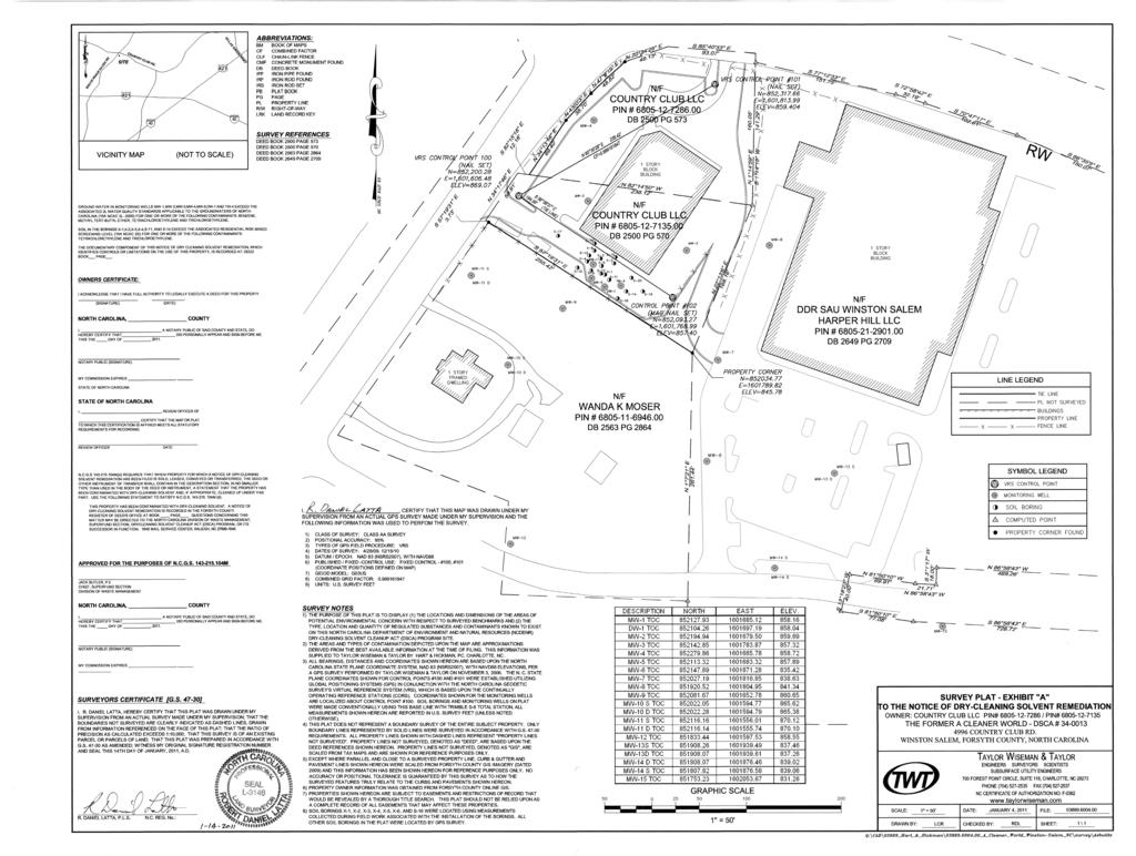
56 EXHIBIT A REDUCTION OF SURVEY PLAT
57
58 EXHIBIT B PROPERTY LEGAL DESCRIPTION
59 Being a certain tract or parcel of land located in Winston-Salem, Forsyth County, North Carolina and being more particularly described as follows: Lot 710 COMMENCING at NCGS "W33 Calvary" NAD 83 (having N.C. Grid Coordinates of North 852,353.70, East 1,601,611.95); thence S '44" E ' Ground Distance (85.28 Grid Distance) to the point of BEGINNING (having N.C. Grid Coordinates of 852,280.47, East 1,601,655.65) and being an existing 7/8" Iron in the eastern right-of-way of Peacehaven Road; thence with the eastern right-of-way of Peacehaven Road the three (3) following courses and distances: 1) N '21" E ' to an existing 7/8" Iron; thence 2) N '38" E ' to an existing bolt; thence 3) N '57" E. 4.34' to a 7/8" Iron placed in the southern right-of-way of Country Club Road as described in Deed Book 2463, Page 3352; thence with the southern right-of-way of Country Club Road the two (2) following courses and distances: 1) S '48" E ' to a point; thence 2) on a curve to the right, having a radius of 1,330.00' and a chord bearing and distance S ' 19" E ' to a 7/8" Iron placed, said iron also being the northeast corner of Lot 710, Tax Block 3908; thence with the eastern line of Lot 710 S '59" W ' to an existing 2" Iron being the southeast corner of Lot 710 and the northeast corner of Lot 804, Tax Block 3908 as described in D. B. 1356, Pg. 631; thence with the southern line of Lot 710 N '18" W ' to an existing 3/4" Rebar, the southwest corner of Lot 710 and being in the eastern right-of-way of Peacehaven Road; thence with the eastern right-of-way of Peacehaven Road N '51" E ' to the place of beginning and containing acres more or less as shown on a survey captioned "Country Club, LLC" prepared by Brady Surveying Company, PA dated July 23, 2004 and designated Dwg No Property Description: Tax Block 3908, Tax Lot 710, Forsyth County Tax Maps Lot 804 COMMENCING at NCGS "W33 Calvary" NAD 83 (having N.C. Grid Coordinates of North 852,353.70, East 1,601,611.95); thence S '44" E ' Ground Distance (85.28 Grid Distance) an existing 7/8" Iron in the eastern right-of-way of Peacehaven Road; thence with the eastern right-of-way of Peacehaven Road S '51" W ' to the point of BEGINNING (having N.C. Grid Coordinates of 852,223.06, East 1,601,616.62) and being an existing 3/4" Rebar, the southwest corner of Lot 710, Tax Block 3908 as described in D. B. 2088, Pg. 947, said iron also being in the northern line of Lot 804, Tax Block 3908 as described in D. B. 1356, Pg. 631; thence with the northern line of Lot 804 S '18" E ' to an existing 2" Iron, the northeast corner of Lot 804; thence with the eastern line of Lot 804 S '06" W ' to an existing 2" Iron, the southeast corner of Lot 804; thence with the southern line of Lot 804 N '31" W. passing an existing 7/8" Iron at ' and continuing 3.73' for a total of ' to a point in Utility Pole and being in the eastern right-of-way of Peacehaven Road; thence with the eastern right-of-way of Peace haven Road N '46" E ' to an existing 7/8" Iron and being the northwest corner of Lot 804; thence with the northern line of Lot 804 S '18" E ' to the place of beginning and containing acres more or less as shown on a survey captioned "Country Club, LLC" prepared by Brady Surveying Company, PA dated July 23, 2004 and designated Dwg No Property Description: Tax Block 3908, Tax Lot 804, Forsyth County Tax Maps Combination of Lots: COMMENCING at NCGS "W33 Calvary" NAD 83 (having N.C. Grid Coordinates of North 852,353.70, East 1,601,611.95); thence S '44" E ' Ground Distance (85.28 Grid Distance) to the point of BEGINNING (having N.C. Grid Coordinates of 852,280.47, East 1,601,655.65) and being an existing 7/8" Iron in the eastern right-of-way of Peacehaven Road; thence with the eastern right-of-way of Peacehaven Road the three (3) following courses and distances: 1)
60 N '21" E ' to an existing 7/8" Iron; thence 2) N '38" E ' to an existing bolt; thence 3) N '57" E. 4.34' to a 7/8" Iron placed in the southern right-of-way of Country Club Road as described in Deed Book 2463, Page 3352; thence with the southern right-of-way of Country Club Road the two (2) following courses and distances: I) S '48" E ' to a point; thence 2) on a curve to the right, having a radius of 1,330.00' and a chord bearing and distance S '19" E ' to a 7/8" Iron placed, said iron also being the northeast corner of Lot 710, Tax Block 3908; thence with the eastern line of Lot 710 S '59" W ' to an existing 2" Iron being the southeast corner of Lot 710 and the northeast corner of Lot 804, Tax Block 3908 as described in D. B. 1356, Pg. 631; thence with the eastern line of Lot 804 S '06" W ' to an existing 2" Iron, the southeast corner of Lot 804; thence with the southern line of Lot 804 N. 57"19'31" W. passing an existing 7/8" Iron at ' and continuing 3.73' for a total of259.15' to a point in Utility Pole and being in the eastern right-of-way of Peacehaven Road; thence with the eastern right-of-way of Peacehaven Road N '46" E ' to an existing 7/8" Iron and being the northwest corner of Lot 804; thence with the northern line of Lot 804 S '18" E ' to an existing 3/4" Rebar, the southwest corner of Lot 710 and being in the eastern right-of-way of Peacehaven Road; thence with the eastern right-of-way of Peacehaven Road N '51" E ' to the place of beginning and containing acres more or less as shown on a survey captioned "Country Club, LLC" prepared by Brady Surveying Company, P A dated July 23, 2004 and designated Dwg No Property Description: Tax Block 3908, Lots 710 and 804, Forsyth County Tax Maps
61 NDCSR for Non-Source Property
62 NOTICE OF DRY-CLEANING SOLVENT REMEDIATION Property Owner: Wanda K Moser, Trustee Recorded in Book, Page Associated plat recorded in Plat Book, Page This documentary component of a Notice of Dry-Cleaning Solvent Remediation (hereinafter Notice ) is hereby recorded on this day of, 20. The survey plat component of the Notice is being recorded concurrently with this documentary component. The real property (hereinafter Property ) which is the subject of this Notice is located at 113 S. Peace Haven Road, Winston-Salem, Forsyth County, North Carolina, Parcel Identification Number (PIN) The Property is contaminated with dry-cleaning solvent, as defined at North Carolina General Statutes (hereinafter N.C.G.S. ), Section (hereinafter ) B(b)(9), and other contaminants and is one of four parcels that make up the dry-cleaning solvent contamination site (hereinafter Contamination Site ). This Notice has been approved by the North Carolina Department of Environment and Natural Resources, or its successor in function (hereinafter DENR ) under the authority of the Dry-Cleaning Solvent Cleanup Act of 1997, as amended, N.C.G.S A et seq. (hereinafter DSCA ), and is required to be filed in the Register of Deeds' Office in the county or counties in which the land is located, pursuant to NCGS I. A Notice will be recorded separately in each chain of title of the Contamination Site. Groundwater under the Property is contaminated with dry-cleaning solvents associated with dry-cleaning operations at the former A Cleaner World facility (DSCA Site ) located at 4996 Country Club Road and along S. Peace Haven Road, Winston-Salem. Pursuant to N.C.G.S I, this Notice is being filed in order to reduce or eliminate the danger to public health or the environment posed by the Property. Attached hereto as Exhibit A is a reduction, to 8 1/2" x 11", of the survey plat component of the Notice required by N.C.G.S M. The survey plat has been prepared and certified by a professional land surveyor and meets the requirements of G.S , and contains the following information required by N.C.G.S M:
63 (1) A description of the location and dimensions of the areas of potential environmental concern with respect to permanently surveyed benchmarks; and (2) The type, location and quantity of regulated dry-cleaning solvent contamination and other contaminants known to exist on the Property. Attached hereto as Exhibit B is a legal description of the Property that would be sufficient as a description in an instrument of conveyance. USE OF GROUNDWATER PROHIBITED BY STATE AND LOCAL REGULATIONS Groundwater on this property contains contaminants that exceed unrestricted use standards. Pursuant to 15A North Carolina Administrative Code 02C.0107(b)(1), (t)he source of water for any water supply well shall not be from a water bearing zone or aquifer that is contaminated. Therefore, state law prohibits construction of a water supply well on this property unless it can be demonstrated that the water pumped from the well is not contaminated. Further, pursuant to North Carolina General Statute 87-88(c) and 15A North Carolina Administrative Code 02C.0112(a), no well may be constructed or maintained in a manner whereby it could be a source or channel of contamination of the groundwater supply or any aquifer. FUTURE SALES, LEASES, CONVEYANCES AND TRANSFERS When any portion of the Property is sold, leased, conveyed or transferred, pursuant to NCGS M the deed or other instrument of transfer shall contain in the description section, in no smaller type than that used in the body of the deed or instrument, a statement that the Property has been contaminated with dry-cleaning solvent and, if appropriate, cleaned up under the DSCA. CANCELLATION OF THE NOTICE The Notice may, at the request of the Property Owner, be canceled by DENR after the risk to public health and the environment associated with the dry-cleaning solvent contamination and any other contaminants included in the DSCA Remediation Agreement have been eliminated as a result of remediation of the Property to unrestricted use standards. APPROVAL AND CERTIFICATION OF NORTH CAROLINA DEPARTMENT OF ENVIRONMENT AND NATURAL RESOURCES The foregoing Notice of Dry-Cleaning Solvent Remediation is hereby approved and certified.
64 North Carolina Department of Environment and Natural Resources By: Jack Butler, Chief Date Superfund Section Division of Waste Management
65 CERTIFICATION OF REGISTER OF DEEDS The foregoing documentary component of the Notice of Dry-Cleaning Solvent Remediation, and the associated plat, are certified to be duly recorded at the date and time, and in the Books and Pages, shown on the first page hereof. Register of Deeds for Forsyth County By: Name typed or printed: Date Deputy/Assistant Register of Deeds
66 EXHIBIT A SURVEY PLAT REDUCTION

67