Understanding and Restoring Natural Floodplain Function. Gary James CTUIR Fisheries Program Manager
|
|
|
- Colleen Hood
- 5 years ago
- Views:
Transcription


1 Understanding and Restoring Natural Floodplain Function Gary James Fisheries Program Manager Future of Our Salmon Technical Workshop on Healthy Floodplains Spokane, WA - August 16-18, 2016
2 Presentation Outline 1. Floodplain Basics! Definition & function! Tribal importance 2. Healthy Floodplain Characteristics and Benefits! Watershed, Biological, Social 3. Floodplain Current Condition and Problems! Current health and physical changes 4. Recommendations! Land! Water


3 Floodplain Basic Facts Definition: Valley bottom land adjacent to a river naturally subject to flooding and longitudinal, lateral and vertical connectivity critical for maintaining biological diversity. Function:! Floodplains are part of natural river systems which are dynamic, with complex channel networks that access the floodplain, creating diverse habitat for fish production in surface waters and full recharge of interconnected groundwater.! Healthy floodplains can improve water quality and quantity, reduce flood damage, and support cultural and recreational opportunities for human communities.

4 Tribal Importance Floodplain Health is critical to accomplishment of mission statements: Department of Natural Resources: To protect, restore, and enhance the First Foods - water, salmon, deer, cous, and huckleberry - for the perpetual cultural, economic, and sovereign benefit of the. We will accomplish this utilizing traditional ecological and cultural knowledge and science to inform: 1) population and habitat management goals and actions; and 2) natural resource policies and regulatory mechanisms. Fisheries Program: Provide sustainable harvest opportunities for aquatic species of the first food order by protecting, conserving and restoring native aquatic populations and their habitats.


5 s First Foods-Based River Vision to Guide Fisheries Restoration First Foods Serving Order: Water Salmon Deer Cous Huckleberry River Vision Touchstones: Hydrology Geomorphology Connectivity Riparian Vegetation Aquatic Biota Goal: Restore Floodplain and Increase First Foods for Tribal Use


6 River Vision Statement The Umatilla basin includes a healthy river capable of providing First Foods that sustain the continuity of the Tribe s culture. This vision requires a river that is dynamic, and shaped not only by physical and biological processes, but the interactions and interconnections between those processes.

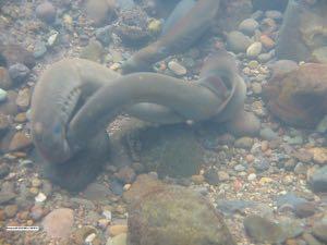

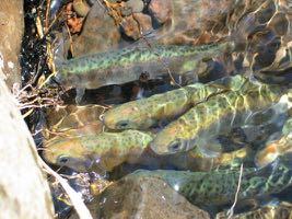
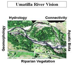
7 River Vision Touchstones Aquatic Biota Healthy Native Species

8 Healthy Floodplain Benefits (Watershed Resources) Natural Flood and Erosion Control! Flood storage and conveyance, reducing flood peaks and velocities! Reduce erosion impacts and sediment loading! Replenish soils, enhancing riparian vegetation Surface Water Quality Maintenance! Filter nutrients and improve water quality! Enhance surface-to-groundwater exchange and temperature reduction Groundwater Recharge! Promote stream access to floodplain for infiltration & aquifer recharge! Reduce frequency & duration of low surface flows (enhance base flow)
9 Temperature/Channel Complexity Relationship 1.0 Channel Complexity Index 14 Temperature Trend Trend in River Temperature River Complexity Index Distance in River Kilometers 0


10 River Vision Application April 3, 2011


11 Healthy Floodplain Benefits (Biologic Resources) Biological Productivity! Increase habitat complexity! Maintain biodiversity of plants and animals, abundance of food - integrity of ecosystem! Increase spawning and rearing habitat by maintaining stream length and access to side channels
12 Healthy Floodplain Benefits (Societal Resources) Harvest of Wild and Cultivated Products! Increase abundance and harvest of native foods associated with floodplain! Enhance agricultural productivity by increasing/maintaining groundwater levels! Enhance and limit loss of agricultural lands by decreasing scour and erosion Provide Cultural, Aesthetic and Recreational Use Values! Contain cultural resources (historic and archeological sites)! Increase recreational opportunities and aesthetic pleasure
13 Current Condition of Floodplains Floodplain Health! About one-third of the once-accessible streams in the Columbia River Basin (about 4,500 miles) is no longer available to salmon.! Endangered Species Act (ESA) recovery planning efforts determined that watershed function for subbasins in NE Oregon and SE Washington ranged from 25-50% due to poor watershed health and floodplain development.! In the Umatilla Subbasin, riparian wetland habitat has declined about 90% due to floodplain development over the last century.
14 Changing Eras and Changing Attitudes Pre-development Era! Abundant Water: Walla Walla name = land of many waters! Abundant Fish: Lewis and Clark journals - Indian encampments Development Era! Local town named Freewater settlement ploy! Floodplain development - stream channelization! Granted water rights exceeded instream flows! Instream flows and salmon went extinct Partnership Era! Model partnerships for water and fish restoration! Cooperative solutions creating enough water to keep both fisheries and agricultural interests whole

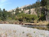
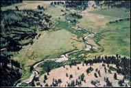
15 Umatilla River near Pendleton loss of meanders due to floodplain development

16 Mouth of Walla Walla River loss of meanders due to channelization

17 Grande Ronde River State Ditch construction cut off 45 stream miles
18 Problems in Floodplains Wrong Management Emphasis! Goal of flood loss reduction! Natural processes in broad floodplains has been second priority! Development-centered uses such as agricultural, municipal and roads have taken precedence over protection of floodplain function Physical Changes! Reduced floodplain area and formation of channelized floodway! Armoring of banks with rip-rap to control erosion! Reduced stream length, increase in gradient & water velocity! Loss of instream and substrate habitat diversity! Disrupted geomorphic processes (channel migration, side channels, islands, sediment transport and sorting and large wood transport)! Over-appropriation of surface flows and shallow groundwater! Construction of dams disrupt fish passage and habitat diversity
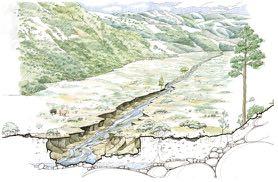
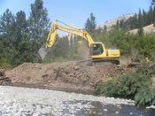
19 Typical Floodplain Development


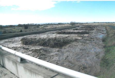
20 6-mile ditch-type reach is constrained by levees and is deeply incised

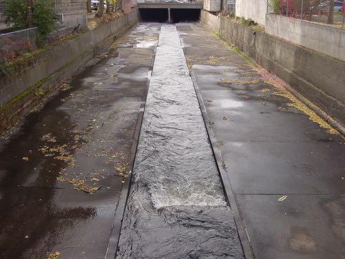
21 Concrete Lining and Channelization-Weirs in Urban Area

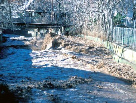
22 Stream Channelized and Surrounded by Urban Development


23 Floodplain Land Management Recommendations 1. Halt or Minimize New Development in Floodplains and Wetlands! Strengthen land use regulations to prohibit further development in floodplains, springs & wetlands and historic stream channels.


24 Feedlot near stream Highway and levee encroachment Concrete backyard stream Ditch runoff erosion Residential and agricultural development Channelization with weirs and summer cesspools

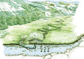
25 Floodplain Land Management Recommendations 2. Reconnect Streams with Floodplains! Identify locations to reclaim natural floodplain habitat and function.! Promote removal or set back of dikes and levees.! Increase area of riparian conservation easements.! Consider condemnation of critical value floodplain developments.! Promote relocation of flood-damaged development rather than redevelopment in floodplain.! Implementation of above floodplain restoration actions may be the best preventative action for minimizing anticipated effects of climate change.


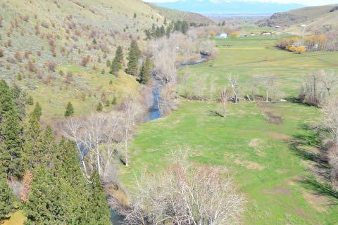
26 Meacham Creek floodplain restoration project - before (2011) and after (2016)

27 North Ditch

 2710 2709 2708 2707 2706 2705")


28 2713 End Cr/Rice at Station Cross Section 2, Riffle, Elevation (ft) Distance (ft), LB to RB Middle End Creek Bed/Ground Elevation Water Surface Bankfull FPA Lower End Creek South Fork Willow

29 Streams Relocated From Straight Property Lines to Former Sinuosity

30 Increased Stream Sinuosity to Access More Floodplain


31 Channel Restoration South Fork Walla Walla River

32 Conservation Easement Bordering Channel Restoration Project
33 Floodplain Water Management Recommendations 1. Surface Water Regulatory Statutes! Increase opportunities or incentives for development of conservation projects such as irrigation efficiency, water transaction projects, shallow aquifer recharge (SAR) and restoration of natural floodplains.! Strengthen water law to identify, quantify and protect increased instream flows resulting from water conservation efforts.! Encourage and develop legal mechanism for irrigators to access groundwater supplies, enhanced through recharge efforts (ASR), in exchange for protected surface flows.! Quantify and protect ecological flows from further appropriation (particularly spring/winter flows which are often considered available ).


34 Floodplain Water Management Recommendations 2. Groundwater Withdrawal Impacts to Surface Flows! Strengthen the legal connection and co-management linkage between surface water rights and groundwater rights and increase regulating groundwater usage impacting surface flows.! Identify areas where floodplain groundwater use impacts surface flow and promote aquifer recharge to lessen impacts. Land surface Shallow well Water table Stream Unconfined aquifer Confined bed


35 Floodplain Water Management Recommendations 3. Monitor, Protect and Enforce Instream Flows! Strengthen state and local monitoring and protection of quantified instream water rights -- particularly new conservation project flows that would otherwise be absorbed by junior water right holders.! Shift water management focus and funding priorities from developing new agriculture water supplies to monitoring and enforcement of existing agricultural rights and protecting new instream water rights Stream dewatering from surface diversions Same reach - increased flow
36 Dual Land and Water Recommendations Integrate Land and Water Management Functions! Entities that manage both floodplain lands and surface/groundwater must acknowledge the inseparable interrelationships and closely integrate the management of all these to fully realize and protect the benefits of a healthy functioning floodplain.! There must be close coordination and integration between groundwater and surface water management entities that acknowledges and limits the impacts that groundwater withdrawals have on surface flows.! Floodplain land or water management entities that have similar responsibilities in neighboring jurisdictional boundaries must have closely integrated and compatible regulatory provisions to fully realize and protect the benefits of a healthy functioning floodplain.
37 QUESTIONS?