No Adverse Impact Floodplain Management
|
|
|
- Ross Davidson
- 5 years ago
- Views:
Transcription
1 No Adverse Impact Floodplain Management June 6, 2013 Beth Lucas, Senior Planner Broome County Planning
2 No Adverse Impact Developed by Association of State Floodplain Managers Purposes: Address the shortcomings of typical local floodplain management programs Provide a higher level of protection for citizens Prevent increased flood damage Goes beyond federal and state programs
3
4 Broome County Event Type Total Number of Occurrences Annual # of Events (average) Flash Flood Urban Flood Flood Total: Table Occurrences of Flood Events in Broome County, , Broome County Hazard Mitigation Plan
5 Municipality Pop SFHA % Pop Pop 0.2% % Pop (1% Flood) 1% Flood Flood 0.2% Flood Barker (T) Binghamton (C) 11, , Binghamton (T) 1, , Chenango (T) 3, , Colesville (T) 2, , Conklin (T) 3, , Deposit (V)* Dickinson (T) 1, , Endicott (V) 4, , Fenton (T) 2, , Johnson City (V) 2, , Kirkwood (T) 2, , Lisle (T) 1, , Lisle (V) Maine (T) 1, , Nanticoke (T) 1, , Port Dickinson (V) 1, , Sanford (T)* Triangle (T) Union (T) 9, , Vestal (T) 7, , Whitney Point (V) Windsor (T) 2, , Windsor (V) Broome County 63, ,
6 Municipality Replacement Cost Value 1% Flood Replacement Cost Value 0.02% Flood Total Loss Payments Barker (T) $47,880,233 $85,257,911 $50,073 Binghamton (C) $1,631,039,145 $2,250,319,760 $15,987,572 Binghamton (T) $1,372,886 $1,372,886 $924,106 Chenango (T) $89,031,744 $208,145,481 $1,993,754 Colesville (T) $91,247,303 $99,780,623 $1,663,581 Conklin (T) $420,466,228 $568,949,648 $30,439,615 Deposit (V) $103,445,365 $185,086,612 $2,793,681 Dickinson (T) $43,399,628 $123,670,593 $1,052,647 Endicott (V) $518,003,192 $724,763,580 $3,292,194 Fenton (T) $73,778,731 $137,813,882 $496,624 Johnson City (V) $255,790,029 $334,608,515 $14,415,601 Kirkwood (T) $214,967,979 $331,980,863 $7,107,908 Lisle (T) $15,279,907 $17,401,014 $11,826 Lisle (V) $21,931,021 $21,931,021 $7,958 Maine (T) $23,146,877 $23,146,877 $634,263 Nanticoke (T) $3,462,533 $9,365,198 $54,735 Port Dickinson (V) $17,571,169 $41,075,261 $363,306 Sanford (T) $3,013,584 $6,744,851 $179,767 Triangle (T) $280,659 $280,659 $0 Union (T) $545,281,586 $692,838,694 $22,028,465 Vestal (T) $470,406,400 $647,577,960 $23,254,448 Whitney Point (V) $119,145,473 $119,145,473 $36,457 Windsor (T) $16,499,814 $19,162,165 $1,252,712 Windsor (V) $52,171,793 $59,022,589 $113,624 Broome County $4,778,613,278 $6,709,442,117 $128,154,915
7 What Is Influencing the Trend? Increased Property at Risk Current policy: Promotes use of high risk areas Ignores changing conditions Ignores adverse impacts to existing properties Undervalues natural floodplain functions
8 Central Message Even if we perfectly implement current standards, damages will increase.
9 Floodplain After Filling
10 Why No Adverse Impact? Flood damages are rapidly increasing unnecessarily! Current approaches deal primarily with how to build in a floodplain vs. how to minimize future damages 10
11 No Adverse Impact Explained NAI is a concept/policy/strategy that broadens one's focus to include how changes to the built environment potentially impact other properties. NAI broadens property rights by protecting the property rights of those that would be adversely impacted by the actions of others.
12 No Adverse Impact Defined Activities that could adversely impact flood damage to another property or community will be allowed only to the extent that the impacts are mitigated or have been accounted for within an adopted community-based plan.

13 Publications and Policy tab Publications No Adverse Impact
14 Community Activities that Can Incorporate NAI: 1. Hazard identification 2. Education and outreach 3. Planning 4. Regulations and standards 5. Mitigation actions 6. Infrastructure 7. Emergency services
15 1. Hazard Identification Basic Flood Insurance Rate Maps (FIRM) Better Fill the data gaps Map hazards not mapped by FEMA Stream bank erosion Ice jams Debris and sediment blockage Active River Areas Levee-protected areas Areas flooded if dams fail Areas that have flooded in the past Localized drainage problems
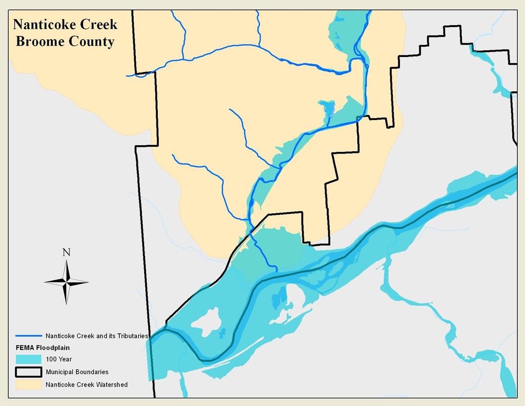
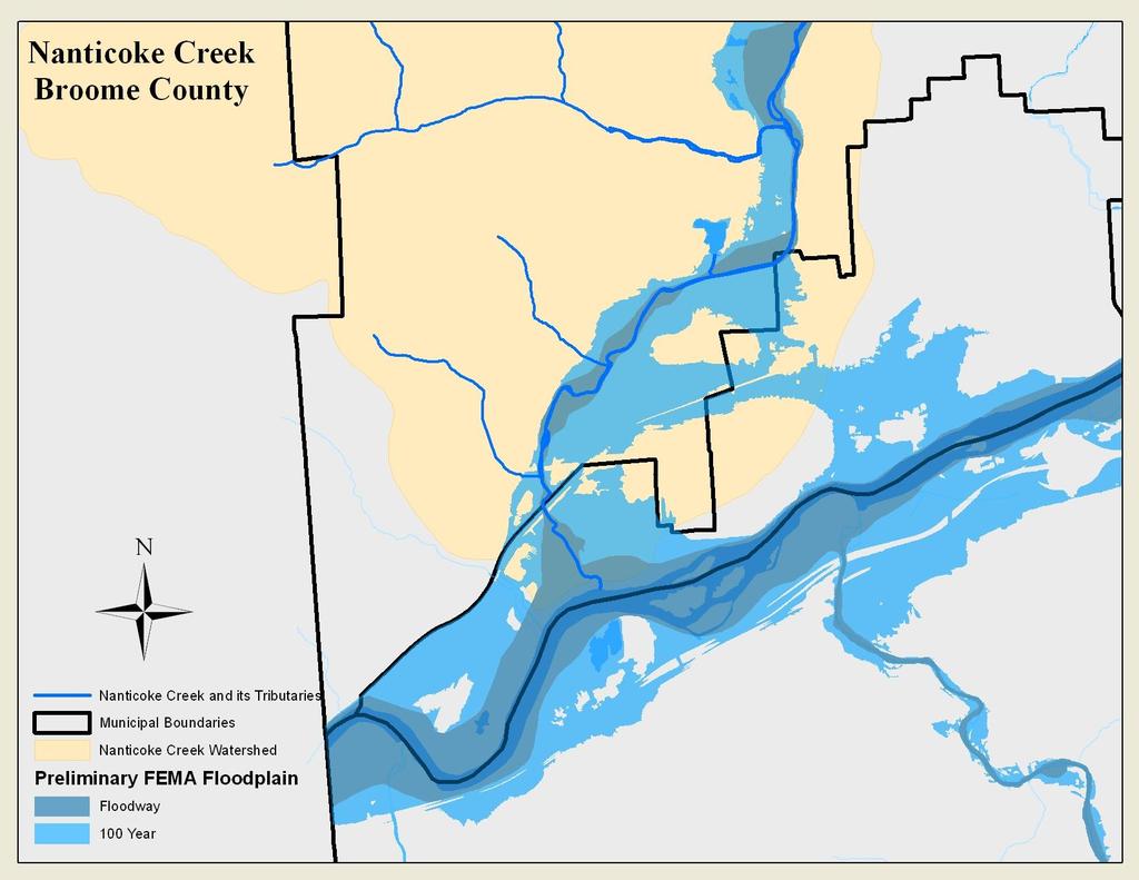
16 2. Education and Outreach Basic Reactive - Answer questions about flood zones and development requirements Better Proactive - Outreach projects targeting specific audiences Key messages: Know your flood hazards Understand how your actions could adversely affect others Protect your property and your neighbors property


17
18 3. Planning Basic Identify mapped flood zones in comprehensive plans Identify natural areas (e.g., steep slopes, wildlife habitat, forests, drinking water source areas) Identify key natural resource areas for protection in municipality's parks and open space plan.

19
20 Fact-finding past, present, and future land use; hydrologic/hydraulic analysis; soil types; slope of the land; rainfall amounts; creek characteristics (size, shape, slope, and roughness); and structural measures in place (culverts, bridges, etc.).
21 Write Specific Policy Statements To strengthen the comprehensive plan s role in conserving the environment, the community can include explicit statements embracing a conservation ethic for protecting nature, as well as specifying what the community wants to accomplish. Consider this example from the Town of Yorktown in Westchester County: Yorktown s natural resources are integral to the long-term health, safety, and well-being of not only Yorktown but also neighboring towns and the region. The town should expand efforts to preserve open space and natural resources throughout Yorktown. The ecological integrity of Yorktown s natural resources including groundwater, streams and wetlands, trees and woodlands, steep slopes, and areas rich in biodiversity must be maintained and protected, even as new development occurs.
22 Better Coordinate with Surrounding Communities Joint Planning or Studies Identify Your Ecological Region and Watershed (1) a characterization of water and land resources; (2) an inventory of stresses or threats to the natural resources; and (3) conservation and management strategies to improve or protect the watershed
23 Nanticoke Creek Watershed 2 Counties 6 Municipalities


24 Green infrastructure planning Open space design and management Riparian buffers Vegetated buffer/setback Native vegetation Allowable uses
25 Best Floodplain management or multi-hazard mitigation plans Plan must be adopted by the municipality in order to obtain funding under certain FEMA programs. In adopting the hazard mitigation plan a community is committing itself to incorporating hazard mitigation activities into their comprehensive plan; zoning; capital expenditure plans; and other local land use activities. Broome County plan is currently awaiting FEMA approval:
26 Multi-objective planning Housing Economic Development Transportation Water Supply Open Space Stormwater Utilities and Community Facilities Other planning opportunities SEQRA and local environmental review laws Conservation or Environmental Boards Critical Environmental Areas
27 4. Regulations and Standards Basic Local Flood Damage Prevention laws Floodplain development requirements in Residential and Building Codes Better Higher standards for floodplain development Address flood hazards in land use regulations
28 Basic - Floodplain Development Standards Local Law for Flood Damage Prevention References Flood Insurance Rate Maps (FIRMs) Local permit Proposed development must be reasonably safe from flood damage Proposed development shall not result in physical damage to any other property


29 Shortcomings: Flood Hazard Maps Maps don t account for Increased development in the watershed Ditches Debris blockage Larger and more frequent storms


30 Shortcomings: What Is the Design Storm? The northeastern US has experienced a 67% increase in very heavy precipitation events.* *National Climatic Data Center
31


32 Shortcomings: Minimum Standards Standards don t account for Erosion Sediment Safety

33 Floodplain After Filling

34 Shortcomings: Outdated Resources
35
36
37 Better Higher Standards for Floodplain Development Freeboard require higher elevation Fill prohibit or restrict the amount of fill Compensatory storage new fill must be offset by excavating floodable area Critical facilities prohibit or higher standards Hazardous materials restrict or implement standards for use, storage, and disposal Substantial improvement lower threshold from 50% to 30%
38 Better Higher Standards for Floodplain Development Floodways (areas where engineer must certify that project will not increase flood elevations) Regulate entire 100-year floodplain as floodway Require floodway analysis for large projects in approximate floodplains Prohibit or limit development and redevelopment
39 Better Higher Standards for Floodplain Development Map additional flood hazard areas Map dam failure inundation areas, leveeprotected areas, or locations with historic flooding problems Reference map in definition of areas of special flood hazard Regulate areas beyond flood zone boundary Apply building elevation requirements to areas where the ground elevation is within two feet above the Base Flood Elevation (100-year flood level)
40 Better - Land Use Regulations Zoning Requirements Restrictions in mapped floodplain / floodway Low density zoning Define appropriate uses Protect sensitive natural areas Stream and shore setbacks for buildings Require site plan review within stream buffer Conservation zone Overlay district for floodplain, stream corridor, erosion hazard area, or buffer zone
41 Better - Land Use Regulations Site Plan Review and/or Special Use Permits Show flood zones and all existing structures Show protection of stream corridors Private stream crossings Require engineering analysis Every lot must have a building site above the flood level Show emergency vehicle access route during a flood
42 Better - Land Use Regulations Subdivision Standards Flood zones must be shown on plat Compensatory storage must offset the loss of flood storage capacity due to fill Protect stream corridors, wetlands, etc.
43 Better - Land Use Regulations Other Opportunities Stream dumping regulations Prohibit dumping or storage in and near streams Stormwater management Promote compliance with state standards Enact higher local standards Timber harvesting regulations Driveway standards
44 5. Mitigation Actions Basic Flood Insurance Structural projects levees, dams Stormwater management County Hazard Mitigation Plans Better Restore natural floodplain functions Protect individual structures Elevation Acquisition Floodproofing
45 Basic 6. Infrastructure Repair after each flood Better Inspect and maintain drainage systems Improve drainage systems without transferring the problems elsewhere Protect critical facilities (listed in HMP) Don t put water or sewer lines in the floodplain Green infrastructure: streamside forests, native vegetation, grass swales, natural sheet flow, wetlands, etc.


46 7. Emergency Services Flood warnings Emergency response Flood safety Pre-planning of emergency operations Inundation maps
47 Legal Research Courts have modified common law doctrines to require an increased standard of care over time Hydraulic, hydrologic, and geologic models facilitate proof of causation Act of God defense has been greatly reduced due to ability to predict hazard events 47
")
48 Legal Research Defense of sovereign immunity has been greatly reduced Communities most apt to have to pay: not when they deny permit, but when development they permit causes damage to others, damage is easily predictable (which is easier to do with better computer models and technology) 48
49 Actions Your Community Can Take Evaluate your hazards and programs Identify existing adverse impacts in the floodplain and throughout the watershed Require adverse impacts to be mitigated when development occurs 49
50 CONCLUSION Current Approaches Create Future Disasters If we continue to encourage at-risk development and ignore the impact to others, can we accept the consequences and, are you willing to pay for it? 50
51 Thank You Beth Lucas Senior Planner, Broome County (607) Thanks to Southern Tier Central Regional Planning who provided the content upon which this presentation is based: Janet Thigpen Southern Tier Central Regional Planning & Development Board (607)