Regulatory Division. Subject: File Number S
|
|
|
- Alexandrina Hood
- 5 years ago
- Views:
Transcription

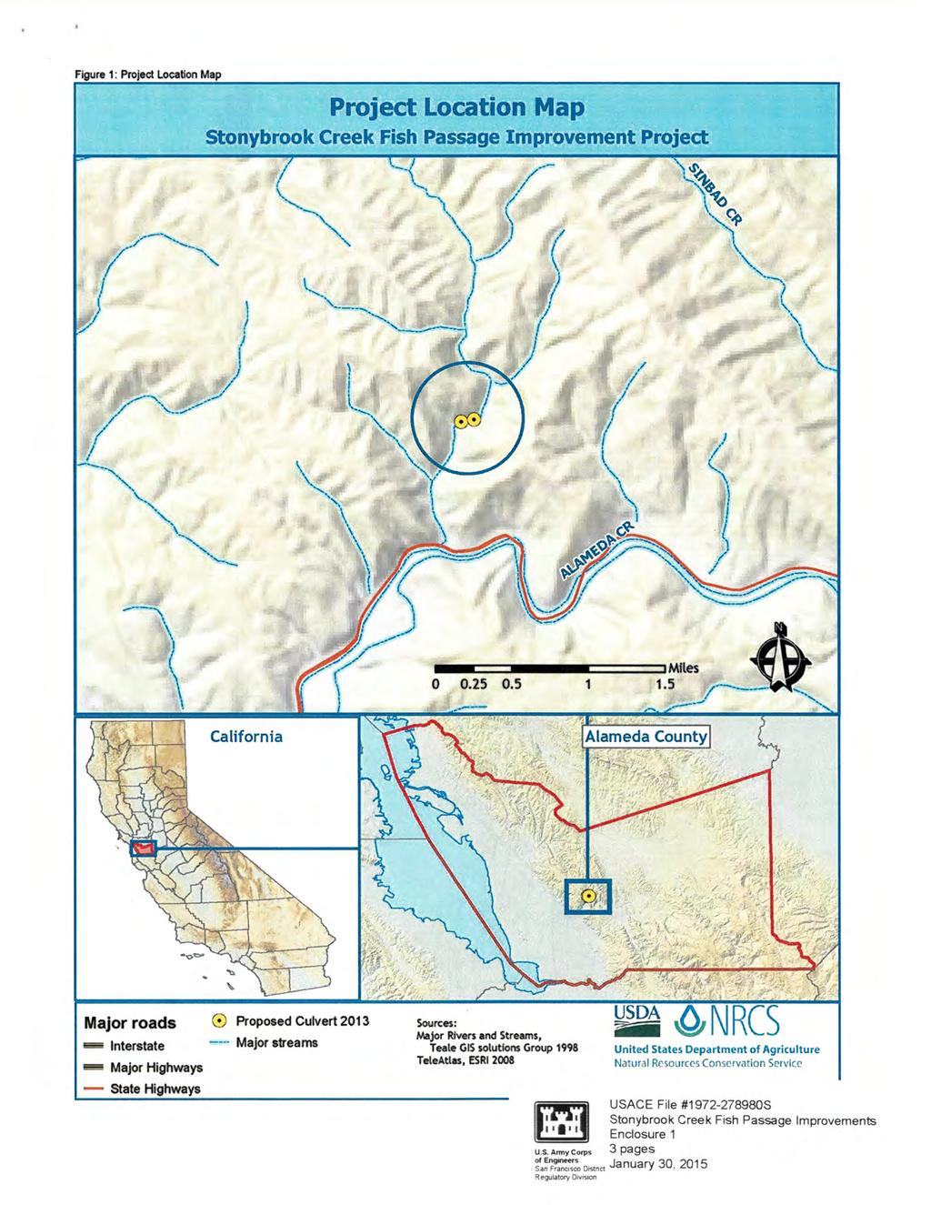
1 DEPARTMENT OF THE ARMY SAN FRANCISCO DISTRICT, U.S. ARMY CORPS OF ENGINEERS 1455 MARKET STREET, 16 TH FLOOR SAN FRANCISCO, CALIFORNIA Regulatory Division Subject: File Number S Ms. Leslie Koenig Alameda County Resource Conservation District 3585 Greenville Road, Suite #2 Livermore, California Dear Ms. Koenig: This correspondence is in reference to your submittal of January 2, 2014, on behalf of the Alameda County Resource Conservation District, concerning Department of the Army (DA) authorization to conduct culvert improvements located at Stonybrook Creek, to Palomares Road, Castro Valley, Alameda County, California, Section 11, Range 1 West, Township 4 South (APNs 085A and 085A ). The approximate coordinates of the project site are North and West. Work within U.S. Army Corps of Engineers (Corps) jurisdiction will include reducing two barriers to anadromous fish passage through culvert improvements at Mile Posts (MP) 8.60 and 8.75 of Palomares Road. The road and the culverts are operated by the Alameda County Public Works Department. The project would include a full replacement of the culvert at MP 8.60 with a prefabricated bridge and a regraded drop to step pools at the outlet; and a culvert retrofit at MP 8.75 including regrading of the existing boulder passage weir and creation of weir baffles in the existing concrete box culvert. Native rocks from a downstream boulder jam would be used for regrading the stream channel at the upper and lower crossings. Any excess material would be removed from the project site. The proposed work would require the permanent placement of 80 cubic yards of fill within 0.28 acre of Stonybrook Creek. All work shall be completed in accordance with the plans and drawings titled USACE File # S, Stonybrook Creek Fish Passage Improvements, date, Figure 1 to 3 provided as enclosure 1. Section 404 of the Clean Water Act (CWA) generally regulates the discharge of dredged or fill material below the plane of ordinary high water in non-tidal waters of the United States, below the high tide line in tidal waters of the United States, and within the lateral extent of wetlands adjacent to these waters. Section 10 of the Rivers and Harbors Act generally regulates construction of structures and work, including excavation, dredging, and discharges of dredged or fill material, occurring below the plane of mean high water in tidal waters of the United States; in former diked baylands currently below mean high water; outside the limits of mean high water but affecting the navigable capacity of tidal waters; or below the plane of ordinary high water in non-tidal waters designated as navigable waters of the United States. Navigable waters of the United States generally include all waters subject to the ebb and flow of the tide;
2 - 2 - and/or all waters presently used, or have been used in the past, or may be susceptible for future use to transport interstate or foreign commerce. A Preliminary Jurisdictional Determination (JD) has been completed for your site. Preliminary JDs are written indications that there may be waters of the U.S. on a parcel or indications of the approximate location(s) of waters of the U.S. on a parcel. Preliminary JDs are advisory in nature and may not be appealed. The basis for this preliminary jurisdictional determination is fully explained in the enclosed Preliminary Jurisdictional Determination Form. You are requested to sign and date this form and return it to this office within two weeks of receipt. Based on a review of the information in your submittal, the project qualifies for authorization under Department of the Army Nationwide Permits (NWPs) 27 for Aquatic Habitat Restoration, Establishment, and Enhancement Activities and 33 for Temporary Construction, Access and Dewatering, 77 Fed. Reg. 10,184 (Feb. 21, 2012) (enclosure 2), pursuant to Section 404 of the CWA of 1972, as amended (33 U.S.C et seq.). The project must be in compliance with the terms of the NWP, the general conditions of the Nationwide Permit Program, and the San Francisco District regional conditions cited in enclosure 3. You must also be in compliance with any special conditions specified in this letter for the NWP authorization to remain valid. Noncompliance with any term or condition could result in the revocation of the NWP authorization for your project, thereby requiring you to obtain an Individual Permit from the Corps. This NWP authorization does not obviate the need to obtain other State or local approvals required by law. This verification will remain valid until March 18, 2017, unless the NWP authorization is modified, suspended, or revoked. Activities which have commenced (i.e., are under construction) or are under contract to commence in reliance upon a NWP will remain authorized provided the activity is completed within 12 months of the date of a NWP s expiration, modification, or revocation, unless discretionary authority has been exercised on a case-by-case basis to modify, suspend, or revoke the authorization in accordance with 33 C.F.R (e) and 33 C.F.R (c) or (d). This verification will remain valid if, during the time period between now and March 18, 2017, the activity complies with any subsequent modification of the NWP authorization. The Chief of Engineers will periodically review NWPs and their conditions and will decide to modify, reissue, or revoke the permits. If a NWP is not modified or reissued within five years of its effective date, it automatically expires and becomes null and void. It is incumbent upon you to remain informed of any changes to the NWPs. Changes to the NWPs would be announced by Public Notice posted on our website ( Upon completion of the project and all associated mitigation requirements, you shall sign and return the Certification of Compliance, enclosure 4, verifying that you have complied with the terms and conditions of the permit. You shall comply with all terms and conditions set forth by the Conditional Water Quality Certification for the Stonybrook Creek Fish Passage Improvement Project in the Community of
3 - 3 - Castro Valley, Alameda County issued by the San Francisco Bay, Regional Water Quality Control Board on September 3, 2014 (enclosure 5). You shall consider such conditions to be an integral part of the NWP authorization for your project. General Condition 18 stipulates that project authorization under a NWP does not allow for the incidental take of any federally-listed species in the absence of a biological opinion (BO) with incidental take provisions. As the principal federal lead agency for this project, the Corps initiated consultation with the United States Fish and Wildlife Service (USFWS) to address project related impacts to listed species, pursuant to Section 7(a) of the Endangered Species Act of 1973, as amended (16 U.S.C et seq.). By letter of January 8, 2015, USFWS issued a BO (08ESMF F-0462) cited in enclosure 6, with an incidental take statement for California red-legged frog (Rana draytonii). In this letter, the USFWS also concurred with the determination that the project was not likely to adversely affect Alameda whipsnake (Masticophis lateralis euryxanthus) and designated critical habitat for this species. In order to ensure compliance with this NWP authorization, the following special conditions shall be implemented: 1. To remain exempt from the prohibitions of Section 9 of the Endangered Species Act, the non-discretionary Terms and Conditions for incidental take of federally-listed California red-legged frog (Rana draytonii) shall be fully implemented as stipulated in the Biological Opinion entitled, 2014 Programmatic Biological Opinion for Issuance of Permits under Section 404 of the Clean Water Act and Section 10 of the Rivers and Harbors Act, including Authorization Under 22 Nationwide Permits, for Projects that May affect the Threatened California Red-Legged Frog in Nine San Francisco Bay Area Counties, California (pages 1-31) dated June 18, 2014 (enclosure 6). Project authorization under the NWP is conditional upon compliance with the mandatory terms and conditions associated with incidental take. Failure to comply with the terms and conditions for incidental take, where a take of a federallylisted species occurs, would constitute an unauthorized take and non-compliance with the NWP authorization for your project. The USFWS is, however, the authoritative federal agency for determining compliance with the incidental take statement and for initiating appropriate enforcement actions or penalties under the Endangered Species Act. 2. The USFWS concurred with the determination that the project was not likely to adversely affect Alameda whipsnake (Masticophis lateralis euryxanthus) and designated critical habitat for this species. This concurrence was premised, in part, on project work restrictions outlined in enclosure 6. These work restrictions are incorporated as special conditions to the NWP authorization for your project to ensure unauthorized incidental take of species and loss of critical habitat does not occur.
4 All standard Best Management Practices shall be implemented to prevent the movement of sediment downstream. No debris, soil, silt, sand, bark, slash, sawdust, cement, concrete, washings, petroleum products, or other organic or earthen material shall be allowed to enter into or be placed where it may be washed by rainfall or runoff into the waterways. 4. A post construction report shall be submitted 45 days after the conclusion of construction activities. The report shall document construction activities and contain as-built drawings (if different from drawings submitted with application) and include before and after photos. 5. Any change in the project design, materials, or construction methods, must be approved by the Corps in writing. 6. A copy of this NWP authorization, and the Section 401 Water Quality Certification, shall be onsite during all work activities and will be available to USACE representatives upon request. 7. The permittee must allow representatives from the San Francisco USACE office or any other person(s) designated by USACE, to inspect the authorized activity at any time deemed necessary to ensure the project is being or has been accomplished in accordance with the terms and conditions of the NWP authorization. 8. If you discover any previously unknown historic or archeological remains while accomplishing the activity authorized by this permit, you must immediately notify this office of what you have found. We will initiate the Federal and State coordination required to determine if the remains warrant a recovery effort, or if the site is eligible for listing in the National Register of Historic Places. You may refer any questions on this matter to Ms. Cameron Purchio of my Regulatory staff by telephone at (707) or by at Cameron.R.Purchio@usace.army.mil. All correspondence should be addressed to the Regulatory Division, North Branch, referencing the file number at the head of this letter. The San Francisco District is committed to improving service to our customers. My Regulatory staff seeks to achieve the goals of the Regulatory Program in an efficient and cooperative manner, while preserving and protecting our nation s aquatic resources. If you would like to provide comments on our Regulatory Program, please complete the Customer
5 - 5 - Service Survey Form available on our website: Regulatory.aspx Sincerely, Enclosures Digital Copy Furnished (w/ encl 1 only): CA RWQCB, Oakland, CA (lperry@waterboards.ca.gov) USFWS, Sacramento, CA (peter_erickson@fws.gov) Jane M. Hicks Chief, Regulatory Division
6
7
8

9
10 Reporting: For those activities that do not require pre-construction notification, the permittee must submit to the district engineer a copy of: (1) The binding stream enhancement or restoration agreement or wetland enhancement, restoration, or establishment agreement, or a project description, including project plans and location map; (2) the NRCS or USDA Technical Service Provider documentation for the voluntary stream enhancement or restoration action or wetland restoration, enhancement, or establishment action; or (3) the SMCRA permit issued by OSMRE or the applicable state agency. The report must also include information on baseline ecological conditions on the project site, such as a delineation of wetlands, streams, and/or other aquatic habitats. These documents must be submitted to the district engineer at least 30 days prior to commencing activities in waters of the United States authorized by this NWP. Notification: The permittee must submit a pre-construction notification to the district engineer prior to commencing any activity (see general condition 31), except for the following activities: (1) Activities conducted on non-federal public lands and private lands, in accordance with the terms and conditions of a binding stream enhancement or restoration agreement or wetland enhancement, restoration, or establishment agreement between the landowner and the U.S. FWS, NRCS, FSA, NMFS, NOS, USFS or their designated state cooperating agencies; (2) Voluntary stream or wetland restoration or enhancement action, or wetland establishment action, documented by the NRCS or USDA Technical Service Provider pursuant to NRCS Field Office Technical Guide standards; or (3) The reclamation of surface coal mine lands, in accordance with an SMCRA permit issued by the OSMRE or the applicable state agency. However, the permittee must submit a copy of the appropriate documentation to the district engineer to fulfill the reporting requirement. (Sections 10 and 404) Note: This NWP can be used to authorize compensatory mitigation projects, including mitigation banks and in-lieu fee projects. However, this NWP does not authorize the reversion of an area used for a compensatory mitigation project to its prior condition, since compensatory mitigation is generally intended to be permanent. Federal Register /Vol. 77, No. 34 /Tuesday, February 21, 2012 /Notices 10269
11 Nationwide Permit 33 - Temporary Construction, Access, and Dewatering Temporary structures, work, and discharges, including cofferdams, necessary for construction activities or access fills or dewatering of construction sites, provided that the associated primary activity is authorized by the Corps of Engineers or the U.S. Coast Guard. This NWP also authorizes temporary structures, work, and discharges, including cofferdams, necessary for construction activities not otherwise subject to the Corps or U.S. Coast Guard permit requirements. Appropriate measures must be taken to maintain near normal downstream flows and to minimize flooding. Fill must consist of materials, and be placed in a manner, that will not be eroded by expected high flows. The use of dredged material may be allowed if the district engineer determines that it will not cause more than minimal adverse effects on aquatic resources. Following completion of construction, temporary fill must be entirely removed to an area that has no waters of the United States, dredged material must be returned to its original location, and the affected areas must be restored to pre-construction elevations. The affected areas must also be revegetated, as appropriate. This permit does not authorize the use of cofferdams to dewater wetlands or other aquatic areas to change their use. Structures left in place after construction is completed require a separate section 10 permit if located in navigable waters of the United States. (See 33 CFR part 322.) Notification: The permittee must submit a pre-construction notification to the district engineer prior to commencing the activity (see general condition 31). The pre-construction notification must include a restoration plan showing how all temporary fills and structures will be removed and the area restored to pre-project conditions. (Sections 10 and 404) Federal Register /Vol. 77, No. 34 /Tuesday, February 21, 2012 /Notices 10269
12
13 11. Equipment. Heavy equipment working in wetlands or mudflats must be placed on mats, or other measures must be taken to minimize soil disturbance. 12. Soil Erosion and Sediment Controls. Appropriate soil erosion and sediment controls must be used and maintained in effective operating condition during construction, and all exposed soil and other fills, as well as any work below the ordinary high water mark or high tide line, must be permanently stabilized at the earliest practicable date. Permittees are encouraged to perform work within waters of the United States during periods of low-flow or no-flow. 13. Removal of Temporary Fills. Temporary fills must be removed in their entirety and the affected areas returned to preconstruction elevations. The affected areas must be revegetated, as appropriate. 14. Proper Maintenance. Any authorized structure or fill shall be properly maintained, including maintenance to ensure public safety and compliance with applicable NWP general conditions, as well as any activity-specific conditions added by the district engineer to an NWP authorization. 15. Single and Complete Project. The activity must be a single and complete project. The same NWP cannot be used more than once for the same single and complete project. 16. Wild and Scenic Rivers. No activity may occur in a component of the National Wild and Scenic River System, or in a river officially designated by Congress as a study river for possible inclusion in the system while the river is in an official study status, unless the appropriate Federal agency with direct management responsibility for such river, has determined in writing that the proposed activity will not adversely affect the Wild and Scenic River designation or study status. Information on Wild and Scenic Rivers may be obtained from the appropriate Federal land management agency responsible for the designated Wild and Scenic River or study river (e.g., National Park Service, U.S. Forest Service, Bureau of Land Management, U.S. Fish and Wildlife Service). 17. Tribal Rights. No activity or its operation may impair reserved tribal rights, including, but not limited to, reserved water rights and treaty fishing and hunting rights. 18. Endangered Species. (a) No activity is authorized under any NWP which is likely to directly or indirectly jeopardize the continued existence of a threatened or endangered species or a species proposed for such designation, as identified under the Federal Endangered Species Act (ESA), or which will directly or indirectly destroy or adversely modify the critical habitat of such species. No activity is authorized under any NWP which may affect a listed species or critical habitat, unless Section 7 consultation addressing the effects of the proposed activity has been completed. (b) Federal agencies should follow their own procedures for complying with the requirements of the ESA. Federal permittees must provide the district engineer with the appropriate documentation to demonstrate compliance with those requirements. The district engineer will review the documentation and determine whether it is sufficient to address ESA compliance for the NWP activity, or whether additional ESA consultation is necessary. (c) Non-federal permittees must submit a pre-construction notification to the district engineer if any listed species or designated critical habitat might be affected or is in the vicinity of the project, or if the project is located in designated critical habitat, and shall not begin work on the activity until notified by the district engineer that the requirements of the ESA have been satisfied and that the activity is authorized. For activities that might affect Federally-listed endangered or threatened species or designated critical habitat, the pre-construction notification must include the name(s) of the endangered or threatened species that might be affected by the proposed work or that utilize the designated critical habitat that might be affected by the proposed work. The district engineer will determine whether the proposed activity may affect or will have no effect to listed species and designated critical habitat and will notify the non-federal applicant of the Corps determination within 45 days of receipt of a complete pre-construction notification. In cases where the non-federal applicant has identified listed species or critical habitat that might be affected or is in the vicinity of the project, and has so notified the Corps, the applicant shall not begin work until the Corps has provided notification the proposed activities will have no effect on listed species or critical habitat, or until Section 7 consultation has been completed. If the non-federal applicant has not heard back from the Corps within 45 days, the applicant must still wait for notification from the Corps. (d) As a result of formal or informal consultation with the FWS or NMFS the district engineer may add species-specific regional endangered species conditions to the NWPs. (e) Authorization of an activity by a NWP does not authorize the take of a threatened or endangered species as defined under the ESA. In the absence of separate authorization (e.g., an ESA Section 10 Permit, a Biological Opinion with incidental take provisions, etc.) from the U.S. FWS or the NMFS, The Endangered Species Act prohibits any person subject to the jurisdiction of the United States to take a listed species, where "take" means to harass, harm, pursue, hunt, shoot, wound, kill, trap, capture, or collect, or to attempt to engage in any such conduct. The word harm in the definition of take'' means an act which actually kills
14 or injures wildlife. Such an act may include significant habitat modification or degradation where it actually kills or injures wildlife by significantly impairing essential behavioral patterns, including breeding, feeding or sheltering. (f) Information on the location of threatened and endangered species and their critical habitat can be obtained directly from the offices of the U.S. FWS and NMFS or their world wide web pages at or and respectively. 19. Migratory Birds and Bald and Golden Eagles. The permittee is responsible for obtaining any take permits required under the U.S. Fish and Wildlife Service s regulations governing compliance with the Migratory Bird Treaty Act or the Bald and Golden Eagle Protection Act. The permittee should contact the appropriate local office of the U.S. Fish and Wildlife Service to determine if such take permits are required for a particular activity. 20. Historic Properties. (a) In cases where the district engineer determines that the activity may affect properties listed, or eligible for listing, in the National Register of Historic Places, the activity is not authorized, until the requirements of Section 106 of the National Historic Preservation Act (NHPA) have been satisfied. (b) Federal permittees should follow their own procedures for complying with the requirements of Section 106 of the National Historic Preservation Act. Federal permittees must provide the district engineer with the appropriate documentation to demonstrate compliance with those requirements. The district engineer will review the documentation and determine whether it is sufficient to address section 106 compliance for the NWP activity, or whether additional section 106 consultation is necessary. (c) Non-federal permittees must submit a pre-construction notification to the district engineer if the authorized activity may have the potential to cause effects to any historic properties listed on, determined to be eligible for listing on, or potentially eligible for listing on the National Register of Historic Places, including previously unidentified properties. For such activities, the pre-construction notification must state which historic properties may be affected by the proposed work or include a vicinity map indicating the location of the historic properties or the potential for the presence of historic properties. Assistance regarding information on the location of or potential for the presence of historic resources can be sought from the State Historic Preservation Officer or Tribal Historic Preservation Officer, as appropriate, and the National Register of Historic Places (see 33 CFR 330.4(g)). When reviewing pre-construction notifications, district engineers will comply with the current procedures for addressing the requirements of Section 106 of the National Historic Preservation Act. The district engineer shall make a reasonable and good faith effort to carry out appropriate identification efforts, which may include background research, consultation, oral history interviews, sample field investigation, and field survey. Based on the information submitted and these efforts, the district engineer shall determine whether the proposed activity has the potential to cause an effect on the historic properties. Where the non-federal applicant has identified historic properties on which the activity may have the potential to cause effects and so notified the Corps, the non-federal applicant shall not begin the activity until notified by the district engineer either that the activity has no potential to cause effects or that consultation under Section 106 of the NHPA has been completed. (d) The district engineer will notify the prospective permittee within 45 days of receipt of a complete pre-construction notification whether NHPA Section 106 consultation is required. Section 106 consultation is not required when the Corps determines that the activity does not have the potential to cause effects on historic properties (see 36 CFR 800.3(a)). If NHPA section 106 consultation is required and will occur, the district engineer will notify the non-federal applicant that he or she cannot begin work until Section 106 consultation is completed. If the non-federal applicant has not heard back from the Corps within 45 days, the applicant must still wait for notification from the Corps. (e) Prospective permittees should be aware that section 110k of the NHPA (16 U.S.C. 470h-2(k)) prevents the Corps from granting a permit or other assistance to an applicant who, with intent to avoid the requirements of Section 106 of the NHPA, has intentionally significantly adversely affected a historic property to which the permit would relate, or having legal power to prevent it, allowed such significant adverse effect to occur, unless the Corps, after consultation with the Advisory Council on Historic Preservation (ACHP), determines that circumstances justify granting such assistance despite the adverse effect created or permitted by the applicant. If circumstances justify granting the assistance, the Corps is required to notify the ACHP and provide documentation specifying the circumstances, the degree of damage to the integrity of any historic properties affected, and proposed mitigation. This documentation must include any views obtained from the applicant, SHPO/THPO, appropriate Indian tribes if the undertaking occurs on or affects historic properties on tribal lands or affects properties of interest to those tribes, and other parties known to have a legitimate interest in the impacts to the permitted activity on historic properties. 21. Discovery of Previously Unknown Remains and Artifacts. If you discover any previously unknown historic, cultural or archeological remains and artifacts while accomplishing the activity authorized by this permit, you must immediately notify the district engineer of what you have found, and to the maximum extent practicable, avoid construction activities that may affect the remains and artifacts until the required coordination has been completed. The district engineer will initiate the Federal, Tribal and state coordination required to determine if the items or remains warrant a recovery effort or if the site is eligible for listing in the National Register of Historic Places.
15 22. Designated Critical Resource Waters. Critical resource waters include, NOAA-managed marine sanctuaries and marine monuments, and National Estuarine Research Reserves. The district engineer may designate, after notice and opportunity for public comment, additional waters officially designated by a state as having particular environmental or ecological significance, such as outstanding national resource waters or state natural heritage sites. The district engineer may also designate additional critical resource waters after notice and opportunity for public comment. (a) Discharges of dredged or fill material into waters of the United States are not authorized by NWPs 7, 12, 14, 16, 17, 21, 29, 31, 35, 39, 40, 42, 43, 44, 49, 50, 51, and 52 for any activity within, or directly affecting, critical resource waters, including wetlands adjacent to such waters. (b) For NWPs 3, 8, 10, 13, 15, 18, 19, 22, 23, 25, 27, 28, 30, 33, 34, 36, 37, and 38, notification is required in accordance with general condition 31, for any activity proposed in the designated critical resource waters including wetlands adjacent to those waters. The district engineer may authorize activities under these NWPs only after it is determined that the impacts to the critical resource waters will be no more than minimal. 23. Mitigation. The district engineer will consider the following factors when determining appropriate and practicable mitigation necessary to ensure that adverse effects on the aquatic environment are minimal: (a) The activity must be designed and constructed to avoid and minimize adverse effects, both temporary and permanent, to waters of the United States to the maximum extent practicable at the project site (i.e., on site). (b) Mitigation in all its forms (avoiding, minimizing, rectifying, reducing, or compensating for resource losses) will be required to the extent necessary to ensure that the adverse effects to the aquatic environment are minimal. (c) Compensatory mitigation at a minimum one-for-one ratio will be required for all wetland losses that exceed 1/10- acre and require pre-construction notification, unless the district engineer determines in writing that either some other form of mitigation would be more environmentally appropriate or the adverse effects of the proposed activity are minimal, and provides a project-specific waiver of this requirement. For wetland losses of 1/10-acre or less that require pre-construction notification, the district engineer may determine on a case-by-case basis that compensatory mitigation is required to ensure that the activity results in minimal adverse effects on the aquatic environment. Compensatory mitigation projects provided to offset losses of aquatic resources must comply with the applicable provisions of 33 CFR part 332. (1) The prospective permittee is responsible for proposing an appropriate compensatory mitigation option if compensatory mitigation is necessary to ensure that the activity results in minimal adverse effects on the aquatic environment. (2) Since the likelihood of success is greater and the impacts to potentially valuable uplands are reduced, wetland restoration should be the first compensatory mitigation option considered. (3) If permittee-responsible mitigation is the proposed option, the prospective permittee is responsible for submitting a mitigation plan. A conceptual or detailed mitigation plan may be used by the district engineer to make the decision on the NWP verification request, but a final mitigation plan that addresses the applicable requirements of 33 CFR 332.4(c)(2) (14) must be approved by the district engineer before the permittee begins work in waters of the United States, unless the district engineer determines that prior approval of the final mitigation plan is not practicable or not necessary to ensure timely completion of the required compensatory mitigation (see 33 CFR 332.3(k)(3)). (4) If mitigation bank or in-lieu fee program credits are the proposed option, the mitigation plan only needs to address the baseline conditions at the impact site and the number of credits to be provided. (5) Compensatory mitigation requirements (e.g., resource type and amount to be provided as compensatory mitigation, site protection, ecological performance standards, monitoring requirements) may be addressed through conditions added to the NWP authorization, instead of components of a compensatory mitigation plan. (d) For losses of streams or other open waters that require pre-construction notification, the district engineer may require compensatory mitigation, such as stream rehabilitation, enhancement, or preservation, to ensure that the activity results in minimal adverse effects on the aquatic environment. (e) Compensatory mitigation will not be used to increase the acreage losses allowed by the acreage limits of the NWPs. For example, if an NWP has an acreage limit of 1/2-acre, it cannot be used to authorize any project resulting in the loss of greater than 1/2-acre of waters of the United States, even if compensatory mitigation is provided that replaces or restores some of the lost waters. However, compensatory mitigation can and should be used, as necessary, to ensure that a project already meeting the established acreage limits also satisfies the minimal impact requirement associated with the NWPs.
16 (f) Compensatory mitigation plans for projects in or near streams or other open waters will normally include a requirement for the restoration or establishment, maintenance, and legal protection (e.g., conservation easements) of riparian areas next to open waters. In some cases, riparian areas may be the only compensatory mitigation required. Riparian areas should consist of native species. The width of the required riparian area will address documented water quality or aquatic habitat loss concerns. Normally, the riparian area will be 25 to 50 feet wide on each side of the stream, but the district engineer may require slightly wider riparian areas to address documented water quality or habitat loss concerns. If it is not possible to establish a riparian area on both sides of a stream, or if the waterbody is a lake or coastal waters, then restoring or establishing a riparian area along a single bank or shoreline may be sufficient. Where both wetlands and open waters exist on the project site, the district engineer will determine the appropriate compensatory mitigation (e.g., riparian areas and/or wetlands compensation) based on what is best for the aquatic environment on a watershed basis. In cases where riparian areas are determined to be the most appropriate form of compensatory mitigation, the district engineer may waive or reduce the requirement to provide wetland compensatory mitigation for wetland losses. (g) Permittees may propose the use of mitigation banks, in-lieu fee programs, or separate permittee-responsible mitigation. For activities resulting in the loss of marine or estuarine resources, permittee-responsible compensatory mitigation may be environmentally preferable if there are no mitigation banks or in-lieu fee programs in the area that have marine or estuarine credits available for sale or transfer to the permittee. For permittee-responsible mitigation, the special conditions of the NWP verification must clearly indicate the party or parties responsible for the implementation and performance of the compensatory mitigation project, and, if required, its long-term management. (h) Where certain functions and services of waters of the United States are permanently adversely affected, such as the conversion of a forested or scrub-shrub wetland to a herbaceous wetland in a permanently maintained utility line right-of-way, mitigation may be required to reduce the adverse effects of the project to the minimal level. 24. Safety of Impoundment Structures. To ensure that all impoundment structures are safely designed, the district engineer may require non-federal applicants to demonstrate that the structures comply with established state dam safety criteria or have been designed by qualified persons. The district engineer may also require documentation that the design has been independently reviewed by similarly qualified persons, and appropriate modifications made to ensure safety. 25. Water Quality. Where States and authorized Tribes, or EPA where applicable, have not previously certified compliance of an NWP with CWA Section 401, individual 401 Water Quality Certification must be obtained or waived (see 33 CFR 330.4(c)). The district engineer or State or Tribe may require additional water quality management measures to ensure that the authorized activity does not result in more than minimal degradation of water quality. 26. Coastal Zone Management. In coastal states where an NWP has not previously received a state coastal zone management consistency concurrence, an individual state coastal zone management consistency concurrence must be obtained, or a presumption of concurrence must occur (see 33 CFR 330.4(d)). The district engineer or a State may require additional measures to ensure that the authorized activity is consistent with state coastal zone management requirements. 27. Regional and Case-By-Case Conditions. The activity must comply with any regional conditions that may have been added by the Division Engineer (see 33 CFR 330.4(e)) and with any case specific conditions added by the Corps or by the state, Indian Tribe, or U.S. EPA in its section 401 Water Quality Certification, or by the state in its Coastal Zone Management Act consistency determination. 28. Use of Multiple Nationwide Permits. The use of more than one NWP for a single and complete project is prohibited, except when the acreage loss of waters of the United States authorized by the NWPs does not exceed the acreage limit of the NWP with the highest specified acreage limit. For example, if a road crossing over tidal waters is constructed under NWP 14, with associated bank stabilization authorized by NWP 13, the maximum acreage loss of waters of the United States for the total project cannot exceed 1/3-acre. 29. Transfer of Nationwide Permit Verifications. If the permittee sells the property associated with a nationwide permit verification, the permittee may transfer the nationwide permit verification to the new owner by submitting a letter to the appropriate Corps district office to validate the transfer. A copy of the nationwide permit verification must be attached to the letter, and the letter must contain the following statement and signature:
17 When the structures or work authorized by this nationwide permit are still in existence at the time the property is transferred, the terms and conditions of this nationwide permit, including any special conditions, will continue to be binding on the new owner(s) of the property. To validate the transfer of this nationwide permit and the associated liabilities associated with compliance with its terms and conditions, have the transferee sign and date below. (Transferee) (Date) 30. Compliance Certification. Each permittee who receives an NWP verification letter from the Corps must provide a signed certification documenting completion of the authorized activity and any required compensatory mitigation. The success of any required permittee-responsible mitigation, including the achievement of ecological performance standards, will be addressed separately by the district engineer. The Corps will provide the permittee the certification document with the NWP verification letter. The certification document will include: (a) A statement that the authorized work was done in accordance with the NWP authorization, including any general, regional, or activity-specific conditions; (b) A statement that the implementation of any required compensatory mitigation was completed in accordance with the permit conditions. If credits from a mitigation bank or in-lieu fee program are used to satisfy the compensatory mitigation requirements, the certification must include the documentation required by 33 CFR 332.3(l)(3) to confirm that the permittee secured the appropriate number and resource type of credits; and (c) The signature of the permittee certifying the completion of the work and mitigation. 31. Pre-Construction Notification. (a) Timing. Where required by the terms of the NWP, the prospective permittee must notify the district engineer by submitting a pre-construction notification (PCN) as early as possible. The district engineer must determine if the PCN is complete within 30 calendar days of the date of receipt and, if the PCN is determined to be incomplete, notify the prospective permittee within that 30 day period to request the additional information necessary to make the PCN complete. The request must specify the information needed to make the PCN complete. As a general rule, district engineers will request additional information necessary to make the PCN complete only once. However, if the prospective permittee does not provide all of the requested information, then the district engineer will notify the prospective permittee that the PCN is still incomplete and the PCN review process will not commence until all of the requested information has been received by the district engineer. The prospective permittee shall not begin the activity until either: (1) He or she is notified in writing by the district engineer that the activity may proceed under the NWP with any special conditions imposed by the district or division engineer; or (2) 45 calendar days have passed from the district engineer s receipt of the complete PCN and the prospective permittee has not received written notice from the district or division engineer. However, if the permittee was required to notify the Corps pursuant to general condition 18 that listed species or critical habitat might be affected or in the vicinity of the project, or to notify the Corps pursuant to general condition 20 that the activity may have the potential to cause effects to historic properties, the permittee cannot begin the activity until receiving written notification from the Corps that there is no effect on listed species or no potential to cause effects on historic properties, or that any consultation required under Section 7 of the Endangered Species Act (see 33 CFR 330.4(f)) and/or Section 106 of the National Historic Preservation (see 33 CFR 330.4(g)) has been completed. Also, work cannot begin under NWPs 21, 49, or 50 until the permittee has received written approval from the Corps. If the proposed activity requires a written waiver to exceed specified limits of an NWP, the permittee may not begin the activity until the district engineer issues the waiver. If the district or division engineer notifies the permittee in writing that an individual permit is required within 45 calendar days of receipt of a complete PCN, the permittee cannot begin the activity until an individual permit has been obtained. Subsequently, the permittee s right to proceed under the NWP may be modified, suspended, or revoked only in accordance with the procedure set forth in 33 CFR 330.5(d)(2).
18 (b) Contents of Pre-Construction Notification: The PCN must be in writing and include the following information: (1) Name, address and telephone numbers of the prospective permittee; (2) Location of the proposed project; (3) A description of the proposed project; the project s purpose; direct and indirect adverse environmental effects the project would cause, including the anticipated amount of loss of water of the United States expected to result from the NWP activity, in acres, linear feet, or other appropriate unit of measure; any other NWP(s), regional general permit(s), or individual permit(s) used or intended to be used to authorize any part of the proposed project or any related activity. The description should be sufficiently detailed to allow the district engineer to determine that the adverse effects of the project will be minimal and to determine the need for compensatory mitigation. Sketches should be provided when necessary to show that the activity complies with the terms of the NWP. (Sketches usually clarify the project and when provided results in a quicker decision. Sketches should contain sufficient detail to provide an illustrative description of the proposed activity (e.g., a conceptual plan), but do not need to be detailed engineering plans); (4) The PCN must include a delineation of wetlands, other special aquatic sites, and other waters, such as lakes and ponds, and perennial, intermittent, and ephemeral streams, on the project site. Wetland delineations must be prepared in accordance with the current method required by the Corps. The permittee may ask the Corps to delineate the special aquatic sites and other waters on the project site, but there may be a delay if the Corps does the delineation, especially if the project site is large or contains many waters of the United States. Furthermore, the 45 day period will not start until the delineation has been submitted to or completed by the Corps, as appropriate; (5) If the proposed activity will result in the loss of greater than 1/10-acre of wetlands and a PCN is required, the prospective permittee must submit a statement describing how the mitigation requirement will be satisfied, or explaining why the adverse effects are minimal and why compensatory mitigation should not be required. As an alternative, the prospective permittee may submit a conceptual or detailed mitigation plan. (6) If any listed species or designated critical habitat might be affected or is in the vicinity of the project, or if the project is located in designated critical habitat, for non-federal applicants the PCN must include the name(s) of those endangered or threatened species that might be affected by the proposed work or utilize the designated critical habitat that may be affected by the proposed work. Federal applicants must provide documentation demonstrating compliance with the Endangered Species Act; and (7) For an activity that may affect a historic property listed on, determined to be eligible for listing on, or potentially eligible for listing on, the National Register of Historic Places, for non-federal applicants the PCN must state which historic property may be affected by the proposed work or include a vicinity map indicating the location of the historic property. Federal applicants must provide documentation demonstrating compliance with Section 106 of the National Historic Preservation Act. (c) Form of Pre-Construction Notification: The standard individual permit application form (Form ENG 4345) may be used, but the completed application form must clearly indicate that it is a PCN and must include all of the information required in paragraphs (b)(1) through (7) of this general condition. A letter containing the required information may also be used. (d) Agency Coordination: (1) The district engineer will consider any comments from Federal and state agencies concerning the proposed activity s compliance with the terms and conditions of the NWPs and the need for mitigation to reduce the project s adverse environmental effects to a minimal level. (2) For all NWP activities that require preconstruction notification and result in the loss of greater than 1/2-acre of waters of the United States, for NWP 21, 29, 39, 40, 42, 43, 44, 50, 51, and 52 activities that require pre-construction notification and will result in the loss of greater than 300 linear feet of intermittent and ephemeral stream bed, and for all NWP 48 activities that require preconstruction notification, the district engineer will immediately provide (e.g., via , facsimile transmission, overnight mail, or other expeditious manner) a copy of the complete PCN to the appropriate Federal or state offices (U.S. FWS, state natural resource or water quality agency, EPA, State Historic Preservation Officer (SHPO) or Tribal Historic Preservation Office (THPO), and, if appropriate, the NMFS). With the exception of NWP 37, these agencies will have 10 calendar days from the date the material is transmitted to telephone or fax the district engineer notice that they intend to provide substantive, site-specific comments. The comments must explain why the agency believes the adverse effects will be more than minimal. If so contacted by an agency, the district engineer will wait an additional 15 calendar days before making a decision on the pre-construction notification. The district engineer will fully consider agency comments received within the specified time frame concerning the proposed activity s compliance with the terms and conditions of the NWPs, including the need for mitigation to ensure the net adverse environmental effects to the aquatic environment of the proposed activity are minimal. The district engineer will provide no response to the resource agency, except as provided below. The district engineer will indicate in the administrative record associated with each pre-construction notification that the resource agencies concerns were considered. For NWP 37, the emergency watershed protection and rehabilitation activity may proceed immediately in cases where there is an unacceptable hazard to life or a significant loss of property or economic hardship will occur. The district engineer will
19 consider any comments received to decide whether the NWP 37 authorization should be modified, suspended, or revoked in accordance with the procedures at 33 CFR (3) In cases of where the prospective permittee is not a Federal agency, the district engineer will provide a response to NMFS within 30 calendar days of receipt of any Essential Fish Habitat conservation recommendations, as required by Section 305(b)(4)(B) of the Magnuson-Stevens Fishery Conservation and Management Act. (4) Applicants are encouraged to provide the Corps with either electronic files or multiple copies of pre-construction notifications to expedite agency coordination.
20 San Francisco District Regional Conditions A. General Regional Conditions that apply to all NWPs in the Sacramento, San Francisco, and Los Angeles Districts: 1. When pre-construction notification (PCN) is required, the permittee shall notify the U.S. Army Corps of Engineers, San Francisco District (Corps) in accordance with General Condition 31 using either the South Pacific Division Preconstruction Notification (PCN) Checklist or a signed application form (ENG Form 4345) with an attachment providing information on compliance with all of the General and Regional Conditions. In addition, the PCN shall include: a. A written statement describing how the activity has been designed to avoid and minimize adverse effects, both temporary and permanent, to waters of the United States; b. Drawings, including plan and cross-section views, clearly depicting the location, size and dimensions of the proposed activity, as well as the location of delineated waters of the U.S. on the site. The drawings shall contain a title block, legend and scale, amount (in cubic yards) and area (in acres) of fill in Corps jurisdiction, including both permanent and temporary fills/structures. The ordinary high water mark or, if tidal waters, the mean high water mark and high tide line, should be shown (in feet), based on National Geodetic Vertical Datum (NGVD) or other appropriate referenced elevation. All drawings for activities located within the boundaries of the Los Angeles District shall comply with the September 15, 2010 Special Public Notice: Map and Drawing Standards for the Los Angeles District Regulatory Division, (available on the Los Angeles District Regulatory Division website at: and c. Numbered and dated pre-project color photographs showing a representative sample of waters proposed to be impacted on the site, and all waters of the U.S. proposed to be avoided on and immediately adjacent to the activities site. The compass angle and position of each photograph shall be identified on the plan-view drawing(s) required in subpart b of this Regional Condition. 2. The permittee shall submit a PCN, in accordance with General Condition 31, For all activities located in areas designated as Essential Fish Habitat (EFH) by the Pacific Fishery Management Council (i.e., all tidally influenced areas - Federal Register dated March 12, 2007, 72 C.F.R. 11,092, in which case the PCN shall include an EFH assessment and extent of proposed impacts to EFH. Examples of EFH habitat assessments can be found at: 3. For activities in which the Corps designates another Federal agency as the lead for compliance with Section 7 of the Endangered Species Act (ESA) of 1973 as amended, 16 U.S.C , Section 305(b)(4)(B) of the Magnuson-Stevens Fishery Conservation and Management Act (EFH), 16 U.S.C. 1855(b)(4)(B) and/or Section 106 of the National Historic Preservation Act (NHPA) of 1966, as amended, 16 U.S.C h, the lead Federal agency shall provide all relevant documentation to the appropriate Corps demonstrating any previous consultation efforts, as it pertains to the Corps Regulatory permit area (for Section 7 and EFH compliance) and the Corps Regulatory area of potential effect (APE) (for Section 106 compliance). For activities requiring a PCN, this information shall be submitted with the PCN. If the Corps does not designate another Federal agency as the lead for ESA, EFH and/or NHPA, the Corps will initiate consultation for compliance, as appropriate. 1
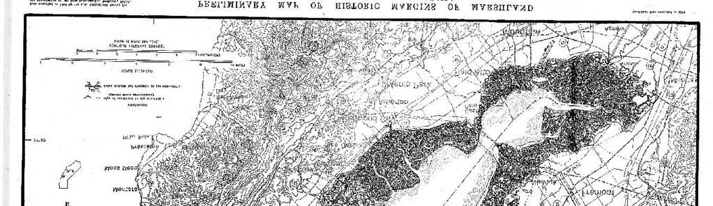
21 4. For all activities in waters of the U.S. that are suitable habitat for Federally-listed fish species, the permittee shall design all road crossings to ensure that the passage and/or spawning of fish is not hindered. In these areas, the permittee shall employ bridge designs that span the stream or river, including pier- or pile-supported spans, or designs that use a bottomless arch culvert with a natural stream bed unless determined to be impracticable by the Corps. 5. The permittee shall complete the construction of any compensatory mitigation required by special condition(s) of the NWP verification before or concurrent with commencement of construction of the authorized activity, except when specifically determined to be impracticable by the Corps. When mitigation involves use of a mitigation bank or in-lieu fee program, the permittee shall submit proof of payment to the Corps prior to commencement of construction of the authorized activity. 6. Any requests to waive the 300 linear foot limitation for intermittent and ephemeral streams for NWPs 21, 29, 39, 40, 42, 43, 44, 50, 51 and 52, or to waive the 500 linear foot limitation along the bank for NWP 13, must include the following: a. A narrative description of the stream. This should include known information on: volume and duration of flow; the approximate length, width, and depth of the waterbody and characteristics observed associated with an Ordinary High Water Mark (e.g. bed and bank, wrack line or scour marks); a description of the adjacent vegetation community and a statement regarding the wetland status of the adjacent areas (i.e. wetland, non-wetland); surrounding land use; water quality; issues related to cumulative impacts in the watershed, and; any other relevant information; b. An analysis of the proposed impacts to the waterbody, in accordance with General Condition 31; c. Measures taken to avoid and minimize losses to waters of the U.S., including other methods of constructing the proposed activity(s); and d. A compensatory mitigation plan describing how the unavoidable losses are proposed to be offset, in accordance with 33 CFR 332. B. General Regional Conditions that apply to all NWPs in the San Francisco District: 1. Notification to the Corps (in accordance with General Condition No. 31) is required for any activity permitted by NWP if it will take place in waters or wetlands of the U.S. that are within the San Francisco Bay diked baylands (see figure 1) (undeveloped areas currently behind levees that are within the historic margin of the Bay. Diked historic baylands are those areas on the Nichols and Wright map below the 5-foot contour line, National Geodetic Vertical Datum (NGVD) (see Nichols, D.R., and N. A. Wright Preliminary map of historic margins of marshland, San Francisco Bay, California. U.S. Geological Survey Open File Map)). The notification shall explain how avoidance and minimization of losses of waters or wetlands are taken into consideration to the maximum extent practicable (see General Condition 23). 2. Notification to the Corps (in accordance with General Condition No. 31) is required for any activity permitted by NWP if it will take place in waters or wetlands of the U.S. that are within the Santa Rosa Plain (see figure 2). The notification will explain how avoidance and minimization of losses of waters or wetlands are taken into consideration to the maximum extent practicable in accordance with General Condition No Notification to the Corps (in accordance with General Condition No. 31), including a compensatory mitigation plan, habitat assessment, and extent of proposed-project impacts 2
22 to Eelgrass Beds are required for any activity permitted by NWP if it will take place within or adjacent to Eelgrass Beds. C. Regional Conditions that apply to specific NWPs in the San Francisco District: 3. MAINTENANCE: 1. To the extent practicable, excavation equipment shall work from an upland site (e.g., from the top of the bank, the road bed of the bridge, or culverted road crossing) to minimize adding fill into waters of the U.S. If it is not practicable to work from an upland site, or if working from the upland site would cause more environmental damage than working in the stream channel, the excavation equipment can be located within the stream channel but it must minimize disturbance to the channel (other than the removal of accumulated sediments or debris). As part of the notification to the Corps (in accordance with General Condition No. 31), an explanation as to the need to place excavation equipment in waters of the U.S. is required, as well as a statement of any additional necessary fill (e.g., cofferdams, access road, fill below the OHW mark for a staging area, etc.). 2. If the activity is proposed in a special aquatic site, the notification to the Corps (in accordance with General Condition No. 31) shall include an explanation of why the special aquatic site cannot be avoided, and the measures to be taken to minimize impacts to the special aquatic site. 11. TEMPORARY RECREATIONAL STRUCTURES: 1. Notification to the Corps (in accordance with General Condition No. 31) is required if any temporary structures are proposed in wetlands or vegetated shallow water areas (e.g. in eelgrass beds). The notification shall include the type of habitat and areal extent affected by the structures. 12. UTILITY LINE ACTIVITIES: 1. Excess material removed from a trench, associated with utility line construction, shall be disposed of at an upland site away from any wetlands or other waters of the U.S. so as to prevent this material from being washed into aquatic areas. 2. This NWP permit does not authorize the construction of substation facilities. Utility line substations can usually be constructed in uplands. 13. BANK STABILIZATION: 1. Notification to the Corps (in accordance with General Condition No. 31) is required for all activities stabilizing greater than 300 linear feet of channel. Where the removal of wetland vegetation (including riparian wetland trees, shrubs and other plants) or submerged, rooted, aquatic plants over a cumulative area greater than 1/10 acre or 300 linear feet is proposed, the Corps shall be notified (in accordance with General Condition No. 31). The notification shall include the type of vegetation and extent (e.g., areal dimension or number of trees) of the proposed removal. The notification shall also address the effect of the bank stabilization on the stability of the opposite side of the streambank (if it is not part of the stabilization activity), and on adjacent property upstream and downstream of the activity. 2. This permit allows excavating a toe trench in waters of the U.S., and, if necessary, to use the material for backfill behind the stabilizing structure. Excess material is to be disposed of in a manner that will have only minimal impacts to the aquatic environment. The notification to the Corps (in accordance with General Condition No. 31) shall include location of the disposal site. 3. For man-made banks, roads, or levees damaged by storms or high flows, the one cubic yard per running foot limit is counted only for that additional fill which encroaches (extends) beyond the pre-flood or pre-storm shoreline condition of the waterway. It is not counted for 3
23 the fill that would be placed to reconstruct the original dimensions of the eroded, man-made shoreline. 4. For natural berms and banks, the one cubic yard per running foot limit applies to any added armoring. 5. To the maximum extent practicable, any new or additional bank stabilization must incorporate structures or modifications beneficial to fish and wildlife (e.g., soil bioengineering or biotechnical design, root wads, large woody debris, etc.). Where these structures or modifications are not used, the applicant shall demonstrate why they were not considered practicable. 14. LINEAR TRANSPORATION PROJECTS: 1. Notification to the Corps (in accordance with General Condition No. 31) is required for all projects filling greater than 300 linear feet of channel. For projects involving greater than 300 linear feet of bank stabilization, the project proponent shall address the effect of the bank stabilization on the stability of the opposite side of the streambank (if it is not part of the stabilization activity), and on adjacent property upstream and downstream of the activity. 2. This permit does not authorize construction of new airport runways and taxiways. 3. If this NWP has been used to authorize previous project segments within the same linear transportation project, justification must be provided demonstrating that the cumulative impacts of the proposed and previously authorized project segments do not result in more than minimal impacts to the aquatic system. 4. To the maximum extent practicable, any new or additional bank stabilization required for the crossing must incorporate structures or modifications beneficial to fish and wildlife (e.g., soil bioengineering or biotechnical design, root wads, large woody debris, etc.). Where these structures or modifications are not used, the applicant shall demonstrate why they were not considered practicable. Bottomless and embedded culverts are encouraged over traditional culvert stream crossings. 23. APPROVED CATEGORICAL EXCLUSIONS: 1. Use of this NWP requires notification to the Corps (in accordance with General Condition No. 31). The notification shall include the following: a. A copy of the Federal Categorical Exclusion (Cat/Ex) document signed by the appropriate federal agency. If the Cat/Ex is signed by a state or local agency representative instead of by a federal agency representative, then copies of all documentation authorizing alternative agency signature shall be provided. b. Written description of Corps authority (e.g., Section 10 of the Rivers and Harbors Act and/or Section 404 of the Clean Water Act.); c. a list of conditions described in the Cat/Ex and/or attachments outlining measures that must be taken prior to, during, or after project construction to minimize impacts to the aquatic environment; d. a copy of the jurisdictional delineation performed by qualified specialists showing the project limits and the location (delineated boundaries) of Corps jurisdiction within the overall project limits; e. map(s) showing the locations of potentially permanent and temporary project impacts to areas within Corps jurisdiction; 4
24 f. a clear and concise description of all project impacts including, but not necessarily limited to: 1. quantification and description of permanent project impacts to areas within Corps jurisdiction, 2. quantification and description of temporary impacts to areas within Corps jurisdiction, and 3. linear extent of Corps jurisdiction affected by the project; g. a general description of activities covered by the Cat/Ex that do not require Corps authorization but are connected or related to the activities in Corps jurisdiction; h. a complete description of any proposed mitigation and/or restoration including, but not necessarily limited to, locations of any proposed planting, short- and long-term maintenance, proposed monitoring, success criteria and contingency plans; i. written justification of how the project complies with the Nationwide Permit Program including less than minimal impact to the aquatic environment and compliance with the General Conditions. j. For Federal Highway Administration (FHWA) Cat/Ex projects, the notification should describe how activities described in the Cat/Ex meet the description of the Cat/Ex project published in the August 28,1987 Federal Register part (a)(b)(c) and (d) (Volume 52, No. 167) or any updated version published in the Federal Register. 2. Only activities specifically described in the Cat/Ex project description will be covered by the NWP 23 authorization. If other activities not described in the Cat/Ex project description will be performed (e.g., dewatering, slope protection, etc.), these activities must receive separate NWP authorizations. 3. Notification to the Corps (in accordance with General Condition 31) must include a copy of the signed Cat/Ex document and final agency determinations regarding compliance with Section 7 of the Endangered Species Act (ESA), Essential Fish Habitat (EFH) under the Magnussen-Stevens Act, and Section 106 of the National Historic Preservation Act. 27. Aquatic Habitat Restoration, Establishment, and Enhancement Activities 1. Notification to the Corps (in accordance with General Condition 31) must include documentation of a review of project impacts to demonstrate that at the conclusion of the work that the project would result in a net increase in aquatic function. Additionally, the documentation must include a review of project impacts on adjacent properties or structures and must also discuss cumulative impacts associated with the project. 29. Residential Developments: 1. When discharge of fill results in the replacement of wetlands or waters of the U.S. with impervious surfaces, to ensure that the authorized activity does not result in more than minimal degradation of water quality (in accordance with General Condition 25), the residential development shall incorporate low impact development concepts (e.g. native landscaping, bioretention and infiltration techniques, and constructed green spaces) to the extent practicable. A description of the low impact development concepts proposed in the project shall be included with the permit application. More information including low impact development concepts and definitions is available at the following website: 2. Use of this NWP is prohibited within the San Francisco Bay diked baylands (undeveloped areas currently behind levees that are within the historic margin of the Bay. Diked historic baylands are those areas on the Nichols and Wright map (see figure 1) below the 5-foot 5
25 contour line, National Geodetic Vertical Datum (NGVD) (see Nichols, D.R., and N. A. Wright Preliminary map of historic margins of marshland, San Francisco Bay, California. U.S. Geological Survey Open File Map)). 33. TEMPORARY CONSTRUCTION, ACCESS, AND DEWATERING: 1. Access roads shall be designed to be the minimum width necessary and shall be designed to minimize changes to the hydraulic flow characteristics of the stream and degradation of water quality (in accordance with General Conditions 9 and 25). The following Best Management Practices (BMPs) shall be followed to the maximum extent practicable to ensure that flow and circulation patterns of waters are not impaired and adverse effects on the aquatic environment will be kept to a minimum: a. The road shall be properly stabilized and maintained during and following construction to prevent erosion. b. Construction of the road fill shall occur in a manner that minimizes the encroachment of trucks, tractors, bulldozers, or other heavy equipment within waters of the United States (including adjacent wetlands) that lie outside the lateral boundaries of the fill itself. 2. Vegetative disturbance in the waters of the U.S. shall be kept to a minimum. 3. Borrow material shall be taken from upland sources whenever feasible. 4. Stream channelization is not authorized by this NWP. 35. MAINTENANCE DREDGING OF EXISTING BASINS: 1. Use of this NWP will require notification to the Corps (in accordance with General Condition No. 31). The notification information should be provided on the Consolidated Dredging- Dredged Material Reuse/Disposal Application. This application and instructions for its completion can be found on our web site at: The information must include the location of the proposed upland disposal site. A jurisdictional delineation of the proposed upland disposal site prepared in accordance with the current method required by the Corps may also be required. 2. The U.S. Coast Guard will be notified by the permittee at least 14 days before dredging commences if the activity occurs in navigable waters of the U.S. (Section 10 waters). 3. The permittee will be required to provide the following information to the Corps: a. Dredge Operation Plan: Submit, for approval by this office, no earlier than 60 calendar days and no later than 20 calendar days before the proposed commencement of dredging, a plan which includes the following: Corps file number, a copy of the dredging contract or description of the work under which the contractor will do the permitted work; name and telephone numbers of the dredging contractor's representative on site; proposed dredging start and completion dates; quantity of material to be removed; dredging design depth and typical cross section including overdepth; and date of last dredging episode and design depth. The Dredge Operational Plan shall also provide the following information: The controls being established to insure that dredging operations occur within the limits defined by the basin or channel dimensions and typical channel section. b. Pre-Dredge Survey: Submit no earlier than 60 calendar days and no later than 20 calendar days before commencement of dredging, a survey with accuracy to one-tenth foot that delineates and labels the following: areas to be dredged with overdepth allowances; existing depths; estimated quantities to be dredged to the design depth; and 6
26 estimated quantities for overdepth dredging. All surveys shall be signed by the permittee to certify their accuracy. Please include the Corps file number. c. Solid Debris Management Plan: Submit no earlier than 60 calendar days and no later than 20 calendar days before commencement of work, a plan which describes measures to ensure that solid debris generated during any dredging operation is retained and properly disposed in areas not under Corps jurisdiction. At a minimum, the plan shall include the following: source and expected type of debris; debris retrieval method; Corps file number; disposal method and site; schedule of disposal operations; and debris containment method to be used, if floatable debris is involved. (Please note that failure to provide all of the information requested in a, b, and c above may result in delays to your project. When your Dredge Operation Plan has been approved, you will receive a written authorization to commence with your project.) d. Post-Dredge Survey: Submit, within 30 days of the last disposal activity ( last is defined as that activity after which no further activity occurs for 15 calendar days), a survey with accuracy to one-tenth foot that delineates and labels the areas dredged and provides the dredged depths. Also, include the Corps file number, actual dates of dredging commencement and completion, actual quantities dredged for the project to the design depth, and actual quantities of overdepth. The permittee shall substantiate the total quantity dredged by including calculations used to determine the volume difference (in cubic yards) between the Pre- and Post-Dredge Surveys and explain any variation in quantities greater than 15% beyond estimated quantities or dredging deeper than is permitted (design plus overdepth allowance). All surveys shall be accomplished by a licensed surveyor and signed by the permittee to certify their accuracy. A copy of the post dredge survey should be sent to the National Ocean Service for chart updating: NOAA/National Ocean Service, Nautical Data Branch N/CS26, SSMC3, Room East-West Highway Silver Spring, Maryland e. The permittee or dredge contractor shall inform this office when: 1) a dredge episode actually commences, 2) when dredging is suspended (suspension is when the dredge contractor leaves the dredge site for more than 48 hours for reasons other than equipment maintenance), 3) when dredging is restarted, and 4) when dredging is complete. Each notification should include the Corps file number. Details for submitting these notifications will be provided in the verification letter (to whom and how). 39. Commercial and Institutional Developments: 1. When discharge of fill results in the replacement of wetlands or waters of the U.S. with impervious surfaces, to ensure that the authorized activity does not result in more than minimal degradation of water quality (in accordance with General Condition 25), the commercial and institutional development shall incorporate low impact development concepts (e.g. native landscaping, bioretention and infiltration techniques, and constructed green spaces) to the extent practicable. A description of the low impact development concepts proposed in the project shall be included with the permit application. More information including low impact development concepts and definitions is available at the following website: 2. Use of this NWP is prohibited within the San Francisco Bay diked baylands (undeveloped areas currently behind levees that are within the historic margin of the Bay. Diked historic baylands are those areas on the Nichols and Wright map (see figure 1) below the 5-foot 7
27 contour line, National Geodetic Vertical Datum (NGVD) (see Nichols, D.R., and N. A. Wright Preliminary map of historic margins of marshland, San Francisco Bay, California. U.S. Geological Survey Open File Map)). 40. AGRICULTURAL ACTIVITIES: 1. This NWP does not authorize discharge of fill into the channel of a perennial or intermittent watercourse that could impede high flows. This limitation does not apply to watercourses that flow only when there is an irregular, extraordinary flood event. 41. RESHAPING EXISTING DRAINAGE DITCHES: 1. Compensatory mitigation may be required if the Corps determines there will be a detrimental impact to aquatic habitat. 2. Notification to the Corps (in accordance with General Condition 31) is required if the applicant proposes to re-grade, discharge, install channel lining, or redeposit fill material. 3. The notification to the Corps (in accordance with General Condition 31) shall include an explanation of the project s benefit to water quality and a statement demonstrating the need for the project. 42. RECREATIONAL FACILITIES: 1. If buildings are proposed to be built in waters of the United States, including wetlands, the applicant must demonstrate that there is no on-site practicable alternative that is less environmentally damaging as defined by the Section 404(b)(1) guidelines. 8


28 Figure 1: Map of Diked Baylands Legend Approximate Landward Extent of Diked Baylands

29 OLIVET RD FULTON RD STONY POINT RD GRANGE RD MILL ST Figure 2: Santa Rosa Plain Map OLD REDWOOD HWY Mendocino Lake Yolo Sutter WESTSIDE RD FRANZ VALLEY RD Sonoma Napa ARATA LN CHALK HILL RD PORTER CREEK RD Solano Marin EASTSIDE RD WINDSOR RD CONDE LN SHILOH RD FAUGHT RD OLD REDWOOD HWY CALISTOGA RD SAINT HELENA RD RIVER RD MIRABEL RD SLUSSER RD AIRPORT BLVD MARK WEST SPRINGS RD FOUNTAIN GROVE PKWY San Francisco Contra Costa Alameda WOHLER RD San Mateo Santa Clara HOPPER AVE PINER RD GRATON RD GREEN VALLEY RD OCCIDENTAL RD GUERNEVILLE RD STATE HWY 12 W STEELE LN W COLLEGE AVE STATE HWY 12 E MENDOCINO AVE HEARN AVE MONTGOMERY DR BENNETT VALLEY RD SUMMERFIELD RD STATE HWY 116 JONIVE RD WATERTROUGH RD LLANO RD US HWY 101 S BARNETT VALLEY RD KENNEDY RD BLOOMFIELD RD CANFIELD RD US HWY 101 N COMMERCE BLVD SNYDER LN PETALUMA HILL RD STATE HWY 1 ROBLAR RD W SIERRA AVE OLD REDWOOD HWY MIDDLE RD STATE HWY 1 ± Legend DILLON BEACH RD TOMALES RD VALLEY FORD RD FALLON RD WALKER RD FALLON RD TOMALES RD Santa Rosa Plain Boundary SPRING HILL RD MEACHAM RD PEPPER RD BODEGA AVE SKILLMAN LN MIDDLE TWO ROCK RD ADOBE RD ELY RD N N MCDOWELL BLVD LAKEVILLE ST ELY BLVD FRATES RD
30 Enclosure 4 Permittee: Leslie Koenig, Alameda County Resource Conservation District File Number: S Certification of Compliance for Nationwide Permit "I hereby certify that the work authorized by the above referenced File Number and all required mitigation have been completed in accordance with the terms and conditions of this Nationwide Permit authorization." (Permittee) (Date) Return to: Ms. Cameron Purchio U.S. Army, Corps of Engineers San Francisco District Regulatory Division, CESPN-R-N 601 Startare Drive, Box 14 Eureka, California 95501
31
32 401 Certification Stonybrook Creek The design at the upstream crossing includes: removal of the existing concrete and masonry culvert while providing temporary traffic access, re-grading of the channel in the vicinity of the crossing, the placement of a new pre-cast concrete arch culvert and wing walls on cast-in-place strip footings and paving the final roadway over the new culvert. Temporary footing, re-grading, and removal of vegetation will be required for temporary equipment and road access. The design at the downstream crossing includes: the installation of angled baffles throughout the box culvert and re-grading the channel to eliminate the severe boulder jam in front of the culvert inlet. The design optimizes fish passage conditions while avoiding a reduction in culvert capacity. To eliminate the boulder jam at the inlet and improve upstream fish passage, the aggraded material will be removed and the channel will be re-graded into step-pool morphology. This is intended to dissipate flow energy and provide fish passage conditions similar to the upstream channel. Impacts: Based on application materials the proposed Project will permanently impact approximately 130 linear feet (0.07 acre) at MP 8.60 by removing the existing culvert and regrading the streambed. Approximately 600 cubic yards of rock and soil will be removed and approximately 100 cubic yards of soil and rock will be placed as permanent fill. At MP 8.75 approximately 250 linear feet (0.02 acre) will be permanently impacted by removing the boulders, re-grading the streambed and installing step pools. Approximately 1500 cubic yards of soil and rock will be removed and approximately 50 cubic yards of rock and soil will be placed as permanent fill. A total of nine trees will be removed as a result of the proposed Project: five at MP 8.60 and four trees at MP 8.75 (please see table). Other trees will require trimming for construction access. # of Plants Greater than 4" DBH Total Plants in Survey Area Tree Species Non-natives Parney's cotoneaster 1 1 1:1 Natives California bay laurel 2 2 9:1 Big leaf maple 2 2 9:1 White alder 2 2 9:1 Coast live oak 2 2 3:1 Proposed Mitigation Ratio Mitigation: The proposed Project is a restoration and habitat improvement project along Stonybrook Creek that will increase fish accessibility, reduce flood potential and improve water quality and sediment loads providing increased security for private landowners. On-site mitigation is proposed to replace the loss of vegetation through the establishment of native riparian vegetation along the stream corridor. California Environmental Quality Act (CEQA): The District filed a Notice of Determination on March 19, 2014 indicating that a Mitigated Negative Declaration was prepared and approved in compliance with CEQA (State Clearinghouse Number ).
33 401 Certification Stonybrook Creek Certification and General Waste Discharge Requirements: I hereby issue an order certifying that any discharge from the referenced Project will comply with the applicable provisions of sections 301 (Effluent Limitations), 302 (Water Quality Related Effluent Limitations), 303 (Water Quality Standards and Implementation Plans), 306 (National Standards of Performance), and 307 (Toxic and Pretreatment Effluent Standards) of the Clean Water Act, and with other applicable requirements of State law. This discharge is also regulated under State Water Resources Control Board Order No DWQ, "General Waste Discharge Requirements for Dredge and Fill Discharges That Have Received State Water Quality Certification" which requires compliance with all conditions of this Water Quality Certification. The following conditions are associated with this certification: 1. No debris, rubbish, creosote-treated wood, soil, silt, sand, cement, concrete, or washings thereof, or other construction related materials or wastes, oil or petroleum products or other organic or earthen material shall be allowed to enter into, or be placed where it may be washed by rainfall or runoff into waters of the State. Any of these materials placed within or where they may enter waters of the State by the District or any party working under contract, or with the permission of the District shall be removed immediately. When construction is completed, any excess material shall be removed from the work area and any areas adjacent to the work area where such material may be washed into waters of the State. During construction, the contractor shall not dump any litter or construction debris within the riparian/stream zone. All such debris and waste shall be picked up daily and properly disposed of at an appropriate site; 2. The District shall adhere to the terms of Nationwide Permit(s) issued by the ACOE; 3. The District shall adhere to the conditions imposed by the California Department of Fish and Wildlife (CDFW) in the Streambed and Lake Alteration Agreement issued for the Project; 4. The Project shall be constructed in conformance with the Project description in the application materials dated December 23, 2014 and in the June 2014 plans titled Stonybrook Creek Crossing Improvements Palomares Road at Postmiles 8.60 and 8.75 Alameda Creek Watershed Project. Any changes to these plans must be submitted to the Water Board s Executive Officer for review and approval before they are implemented; 5. The District shall establish a minimum of four (4) permanent photo-documentation points at the Project site(s). The District shall prepare site maps with the photo-documentation points clearly marked. Prior to implementing the Project, the District shall photodocument the condition of the Project site. Following implementation of the Project and tree planting, the District shall photographically document the immediate postconstruction condition of the site and submit a report to the Water Board including the pre-construction photographs, the post-construction photographs, and the map with the locations of the photo-documentation points; 6. The District shall submit annual monitoring reports acceptable to the Water Board Executive Officer no later than January 31 st of each year until the tree planting plan has been successfully completed, but for not less than a period of five years. If the tree plantings indicate that establishment of the riparian habitat is not progressing in a manner or rate consistent with that expected by the District, the annual monitoring reports shall evaluate the probable cause(s) of any problems and propose appropriate corrective measures;
34 401 Certification Stonybrook Creek 7. All work performed within waters of the State shall be completed in a manner that minimizes impacts to beneficial uses and habitat; measures shall be employed to minimize disturbances along Stonybrook Creek that will adversely impact the water quality of waters of the State. Disturbance or removal of vegetation shall not exceed the minimum necessary to complete Project implementation; 8. Erosion control measures shall be utilized throughout all phases of construction where sediment runoff from disturbed areas threatens to enter waters of the State. At no time shall silt-laden runoff be allowed to enter waters of the State; 9. Prior to the start of construction, the District shall provide a dewatering plan, including the area to be dewatered, timing of dewatering, and method of dewatering to be implemented, to the Executive Officer of the Water Board for review and approval. All temporary dewatering methods shall be designed to have the minimum necessary impacts to waters of the State to isolate the immediate work area. All dewatering methods shall be installed such that natural flow is maintained upstream and downstream of the project area. Any temporary dams or diversions shall be installed such that the diversion does not cause sedimentation, siltation, or erosion upstream or downstream of the project area. All dewatering methods shall be removed immediately upon completion of Project activities; 10. No later than 24 hours prior to the start of a likely rain event, the District shall ensure that disturbed areas that drain to waters of the State are protected with correctly installed erosion control measures (e.g., jute, straw, coconut fiber erosion control fabric, coir logs, straw, etc.). The likely rain event is defined as any weather pattern that is forecast to have a 50% or greater probability of producing precipitation in the Project area. The Water District shall obtain a daily printed copy of the precipitation forecast information (and keep for record) from the National Weather Service Forecast Office(e.g., by entering the zip code of the Project s location at This certification action is not intended and shall not be construed to apply to any discharge from any activity involving a hydroelectric facility requiring a Federal Energy Regulatory Commission (FERC) license or an amendment to a FERC license unless the pertinent certification application was filed pursuant to 23 CCR Subsection 3855(b) and that application specifically identified that a FERC license or amendment to a FERC license for a hydroelectric facility was being sought; and, 12. Certification is conditioned upon total payment of the full fee required in State regulations (23 CCR Section 3833). Payment in full was received December 23, Please be aware that any violation of water quality certification conditions is a violation of State law and subject to administrative civil liability pursuant to California Water Code (CWC) Section Failure to respond, inadequate response, late response, or failure to meet any condition of a certification or waiver may subject the District to civil liability imposed by the Water Board to a maximum of $5,000 per day of violation or $10 for each gallon of waste discharged in violation of this action. Any requirement for a report made as a condition to this action is a formal requirement pursuant to CWC Section 13267, and failure or refusal to provide, or falsification of such requirement report is subject to civil liability as described in CWC Section If you have questions, please contact Leslie Perry at lperry@waterboards.ca.gov or at All future correspondence regarding this Project should reference CIWQS No
35 401 Certification Stonybrook Creek Sincerely, Bruce H. Wolfe Executive Officer Cc via SWRCB-DWQ, Bill Orme Stateboard401@waterboards.ca.gov U.S. EPA, Jason Brush, WTR-8 R9-WTR8-Mailbox@epa.gov CDFW, Bay Delta Region, Marcia Grefsrud mgrefsrud@wildlife.ca.gov ACOE San Francisco Regulatory Branch, Holly Costa, holly.n.costa@usace.army.mil Alameda County Flood Control & Water Conservation District, Kwablah Attigobe kwablah@acpwa.org
36
37
38
39

40

41
42
43