City Pacifica Sea Level Rise Local Coastal Plan (LCP) Update
|
|
|
- Julian Gaines
- 5 years ago
- Views:
Transcription
 Update August 11, 2018 Public Workshop #5")
1 City Pacifica Sea Level Rise Local Coastal Plan (LCP) Update August 11, 2018 Public Workshop #5 1
2 Welcome and Introductions
3 Meeting Objectives Provide an overview of the sea level rise planning process, including work completed to date, where we are now, and where we are headed. Review and discuss Final Draft Adaptation Plan, including measures identified for specific locations in Pacifica s coastal zone, cost-benefit analyses of alternatives, and near-term adaptation measures. Provide participants with the opportunity to ask questions and provide comments.
4 Meeting Agenda 12:00 p.m. Welcome, Agenda Review and Introductions 12:10 p.m. Update on Sea Level Rise Planning Process 12:20 p.m. Adaptation Plan Overview Cost-benefit analysis 12:35 p.m. Adaptation Plan Priority Recommendations Geomorphic settings, assets, and vulnerabilities Cost-benefit analysis results 1:25 p.m. Public Comment and Q&A 3:00 p.m. Adjourn
5 Proposed Ground Rules Please: 1. Focus your input on the meeting objectives 2. Honor the agenda and time limits for discussion 3. Interact respectfully 4. Turn off or silence cell phones
6 Public Participation During Meeting Public comment will be invited at end of meeting. Please fill out comment/question card. Attendees can also provide input by submitting comment forms.
7 Sea Level Rise Planning Process
8 Pacifica s Local Coastal Plan Need for Update Current LCP land use policies adopted in Draft LCP Update prepared, but not adopted. Draft LCP Update does not consider sea level rise impacts or provide adaptation policies. Incorporating the Adaptation Plan will bring the document into conformance with Coastal Commission policy guidance.


9 Sea Level Rise LCP Update Project Goals Bolster efficacy of public safety efforts. Respond to climate change. Preserve Existing Neighborhoods and Promote Environmental Justice and Local Economic Vitality. Preserve and enhance coastal access.


10 Sea Level Rise & Adaptation Planning Coastal Commission Guidance Identify SLR Projections Implement LCP and Monitor/ Revise Identify Potential Impacts Updated LCP Assess Risks Adaptation Measures/ Policy Options

11 Updated Schedule

12 Updated Schedule Once Draft LCP Policies regarding Sea Level Rise Adaptation are approved by City Council, City staff will work towards reintroducing the Draft General Plan and the Draft LCP, which covers various topics beyond adapting to sea level rise, to the public for Council approval and adoption.

13 Follow the LCP Update Online City project website:
14 Adaptation Plan Overview
15 Development of Adaptation Plan Purpose: Develop adaptation strategies that are consistent with City Goals to enable Pacifica to manage vulnerabilities to coastal hazards and SLR Inform the development of SLR Policies to be included in the LCP update Factors that inform the Adaptation Plan: Existing conditions Vulnerability Assessment Project Goals adopted by the City Geomorphic setting along the coast Cost-Benefit Analysis of adaptation alternatives
16 Cost Benefit Analysis Development of Adaptation Alternatives Develop list of applicable measures to address vulnerabilities E.g. armor, nourish beach, transfer of development credits, etc. Evaluate list for suitability: Does the measure protect existing development (where applicable)? Does the measure align with community values (public and work group input received throughout project to date)? I the measure compatible with geographic/morphologic setting (is there space/right conditions for success)? Does the measure support and/or improve existing recreational and ecological functions? Compile measures to create alternative adaptation strategies for each sub-area
17 Cost Benefit Analysis Adaptation Alternatives Overview Alternative 1 Protect Maintain existing armoring, build new armor as needed Improve flood protection in place Alternative 2 Protect & Accommodate Maintain existing armoring, build new armor as needed Nourish beaches for recreation, ecology and backshore protection Improve flood protection with accommodation Alternative 3 Managed realignment and relocation Managed removal of property and infrastructure as needed to avoid flooding and erosion hazards Optional for property owners
 Update hazard zones Re-run hazard exposures in GIS Economics Start with")
 Alt 3 Impacts Alt 1")
18 Cost Benefit Analysis Methodology Overview Engineering cost estimates of alternatives (using triggers) Update hazard zones Re-run hazard exposures in GIS Economics Start with County Parcel Data Update Property Values Add in Government Property/Infrastructure Add in Beach and other Recreation (See Section 5 of Adaptation Plan) Alt 3 Impacts Alt 1 Impacts
19 Limits of Economic Analysis Our Knowledge of Geophysical Changes is Limited Market Value may not be Representative of True Value Relative Costs Change over Time Ecosystem Services Difficult to Value
20 Adaptation Plan Priority Recommendations

21 Pacifica Sub-areas


22 Sharp Park, West Fairway Park and Mori Point Background Geomorphic Setting Assets Low armored bluffs Existing beach widest at Mori Pt, disappears around Pier Low lying neighborhoods around golf course Mori Point open space and tall bluffs Residential and Commercial, Gov t Beaches, trails, SPGC, promenade, habitat, coastal access Sewer infrastructure, other public infrastructure Vulnerabilities Wave run-up along Beach Boulevard Flooding around SPGC Erosion
23 Sharp Park, West Fairway Park and Mori Point Cost-Benefit Analysis Results Figure 20 in final draft Adaptation Plan
24 Armoring Sharp Park, West Fairway Park and Mori Point Adaptation Priorities (immediately) Maintain and expand coastal armoring (~1 ft SLR) Raise seawalls to limit wave overtopping 2050 (~2 feet SLR) Wave overtopping may become unmanageable with 2-3 feet SLR and further actions such as elevating structures or utility relocation may be needed. Beach Nourishment (immediately) Nourish beach to reduce armoring maintenance needs and provide recreation and ecology benefits. By constructing sand retention structures along north Pacifica, the efficacy of beach nourishments can be increased. Flood Protection (immediately) Construct Clarendon Ave stormwater basin, pump station, and interior SPGC levee to protect homes and businesses from existing fluvial storm flood hazard zone (~3 ft SLR) Construct West Fairway Park stormwater basin, pump station, and interior SPGC levee to protect western homes from future coastal/fluvial flood hazard zone. Managed Retreat/Realignment (mid to long term) 2050 May be needed as Plan B for public infrastructure, optional to property owners.


25 Rockaway Beach, Quarry and Headlands Background Geomorphic Setting Tall undeveloped bluffs Low armored bluffs in cove Unarmored south cove Assets Commercial, Hotels, residential Sewer Pump Station Beach, trails, access Vulnerabilities Erosion of bluffs, cove Wave run-up and overtopping along developed cove
26 Rockaway Beach, Quarry and Headlands Cost-Benefit Analysis Results Figure 21 in final draft Adaptation Plan
27 Rockaway Beach, Quarry and Headlands Cost-Benefit Analysis Results
28 Armoring Rockaway Beach, Quarry and Headlands Adaptation Priorities 2020 to 2030 (immediately) upgrade existing public armoring structures along north cove 2050 to 2060 (~2-3 ft SLR, or when backshore is within 100 feet of Hwy 1 embankment) install revetment for Highway 1 embankment Beach Nourishment (immediately) plan and implement beach nourishment of entire cove. Rockaway is a favorable location with best potential for testing nourishment as an adaptation strategy. By nourishing the beach, maintenance needs for backshore armoring are reduced Flood Protection 2030 (immediately) Improve coastal armoring to reduce wave overtopping Transfer of Development Credits TDRs can be implemented on undeveloped parcels to avoid vulnerability to bluff erosion. Managed Retreat/Realignment (mid to long term) Remove/relocate south cove public parking and restrooms when impacted by erosion May be needed as Plan B if erosion is not managed, optional to property owners


29 Geomorphic Setting Fairmont West Background Tall, mostly undeveloped bluffs Assets Historic site Scenic bluffs Road and sewer infrastructure Beach Vulnerabilities Bluff erosion could impact road and sewer by 2050, historic site earlier.
30 Armoring Fairmont West Adaptation Priorities (~1 ft SLR) private armoring structures are maintained/upgraded by property owners (~1-2 ft SLR) construct armoring to protect public road and sewer line if beach is not nourished and erosion continues. Beach Nourishment (~2 ft SLR, or bluff toe within 260 feet of infrastructure) place large ( foot) beach nourishment to buffer backshore and provide recreation and ecology benefits. Sand retention structures will increase the efficacy of beach nourishment. Transfer of Development Credits TDRs could be implemented on undeveloped parcels to limit future vulnerability to bluff erosion. Managed Retreat/Realignment (mid to long term) (~2-4 ft SLR) realign road and sewer if coastal armoring or beach nourishment is not feasible. Palmetto serves as the primary access route for the Fairmont West neighborhood so a detailed transportation study will be required if managed realignment of Palmetto is considered. Optional to property owners


31 West Edgemar and Pacific Manor Background Geomorphic Setting Tall, mostly developed and armored bluffs Assets Residential, commercial property Public roads and infrastructure Beach access, pocket beaches. Vulnerabilities Erosion impacts to blufftop property and infrastructure
32 Armoring West Edgemar and Pacific Manor Adaptation Priorities (immediately) maintain and expand armoring structures to protect public infrastructure. The City is currently proceeding with new armoring along bluffs between Bill Drake Way and Manor Dr. to protect Esplanade Ave. and public utilities (~1 ft SLR) property owners may maintain and expand armor on private property Beach Nourishment (immediately) nourish beach to reduce armoring maintenance requirements and provide recreation and ecology benefits. Sand retention structures will increase the efficacy of beach nourishment. Managed Retreat/Realignment (mid to long term) 2050 May be needed as Plan B if erosion is not managed Optional to property owners


33 Geomorphic Setting Northwest Sharp Park Background Low-medium armored bluffs Assets Residential, industrial property Vertical coastal access Beaches Vulnerabilities Erosion impacts to blufftop properties Wave overtopping damages to property possible with only 1 foot SLR
34 Armoring Northwest Sharp Park Adaptation Priorities (immediately) maintain and expand armoring structures to protect public infrastructure (~1 ft SLR) property owners may maintain and expand armor on private property, armor upgrades to limit wave overtopping will also be needed without beach nourishment. Beach Nourishment (immediately) nourish beach to reduce armoring maintenance requirements and provide recreation and ecology benefits. Sand retention structures will increase the efficacy of beach nourishment (at an additional cost). Flood Protection (~1 ft SLR) enable property owners to manage wave overtopping with structural improvements or raising structures. Managed Retreat/Realignment (1-2 ft SLR) Timing is dependent on location of built assets relative to the bluff edge and implementation/efficacy of protection strategies. Private structures are at the threshold for significant damage from wave run-up and overtopping of the armored bluff face. Optional to property owners.


35 West Linda Mar & Pacifica State Beach Background Geomorphic Setting Assets Beaches/Dunes and low backshore Low lying neighborhood Commercial, residential property Sewer and Storm infrastructure Highway 1 Public Access Beaches and wetlands, river. Vulnerabilities River flooding in West Linda Mar, groundwater Erosion and wave run-up along Pacifica State Beach affects oceanfront development and infrastructure, Highway 1 could withstand 2 ft SLR
36 Armoring West Linda Mar & Pacifica State Beach Adaptation Priorities (~2 ft SLR or 100 foot offset from shoreline to assets) build/upgrade armoring along PSB parking lot and construct new armor at south parking lot/linda Mar pump station City to engage with Caltrans to protect Highway 1. Beach Nourishment (~2 ft SLR or 100 foot offset from dune toe to Highway 1) nourish beach and restore dunes as needed to protect sewer force main and/or Highway 1. Flood Protection (immediately) construct floodwall along commercial property to manage flooding from San Pedro Creek under existing conditions with SLR allowance (immediately) floodproof Anza pump station (stormwater) (~2 feet SLR) floodproof Linda Mar pump stations (sewer and storm). Groundwater Management (~0-2 feet SLR) begin groundwater monitoring in West Linda Mar to assess need for dewatering wells. Managed Retreat/Realignment (mid to long term) 2050 May be needed as Plan B if erosion and flooding are not managed Optional to property owners

37 Pedro Point and Shelter Cove Background Geomorphic Setting Beaches and low backshore Tall unarmored bluffs Assets Residential and Commercial Wetlands, open space, small beach Public roads and infrastructure Vulnerabilities Existing wave run-up hazards along beaches Erosion impacts to low backshore and blufftop development Flooding of commercial parking lot with SLR
38 Armoring Pedro Point and Shelter Cove Adaptation Priorities (immediately) enable property owners to update coastal armor structures to more resilient designs (when bluff erosion infringes on property) private property is vulnerable to bluff erosion, but implementing bluff toe armoring would be complicated due to land ownership. Develop a hazard mitigation program: The program would be subject to available funding and voluntary action by property owners. Beach Nourishment Nourishment for Pacifica State Beach shall include area south of San Pedro Creek Flood Protection (~0-1 feet SLR) amend zoning and policy documents to allow private property owners to raise homes and other structures above wave run-up hazard. Transfer of Development Credits TDRs could be implemented on undeveloped parcels to limit future vulnerability to bluff erosion. Managed Retreat/Realignment (mid to long term) 2050 May be needed as Plan B if erosion is not managed Optional to property owners
39 Sea Level Rise LCP Update Next Steps Public comments on Final Draft Adaptation Plan currently being accepted. Comment period closes on August 29, Fill out a comment form today Send comments to: sealevelrise@ci.pacifica.ca.us Develop Policies to address SLR. Release Draft Local Coastal Plan Policies for public review on September 10, Next Public Workshop to review draft Policies When: Saturday, September 15 th Where: Community Center, 12:00pm 3:00pm.
40 Backup Information Slides
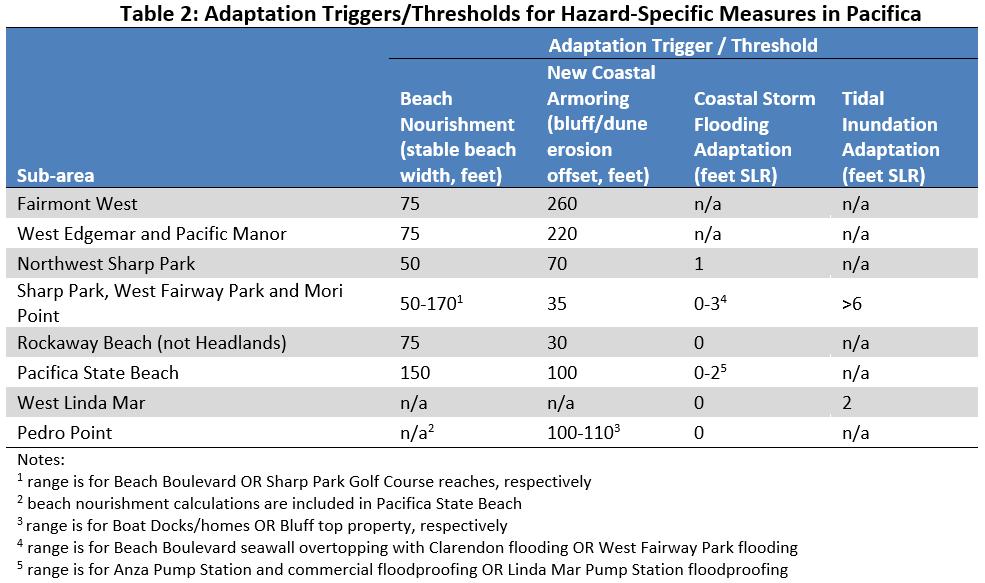
41 Adaptation Triggers


42 Fairmont West Cost-Benefit Analysis Results Figure 17 in final draft Adaptation Plan

43 West Edgemar and Pacific Manor Cost-Benefit Analysis Results Figure 18 in final draft Adaptation Plan


44 Northwest Sharp Park Cost-Benefit Analysis Results Figure 19 in final draft Adaptation Plan
45 Sharp Park, West Fairway Park and Mori Point Cost-Benefit Analysis Results Figure 20 in final draft Adaptation Plan
46 Rockaway Beach, Quarry and Headlands Cost-Benefit Analysis Results Figure 21 in final draft Adaptation Plan

47 Rockaway Beach, Quarry and Headlands Cost-Benefit Summary

48 West Linda Mar & Pacifica State Beach Cost-Benefit Analysis Results Figure 22 in final draft Adaptation Plan

49 West Linda Mar & Pacifica State Beach Cost-Benefit Summary

50 Pedro Point and Shelter Cove Cost-Benefit Analysis Results Figure 23 in final draft Adaptation Plan
51 Summary of Econ. Methods (Table 12, p. 55) Table 1. Summary of Methods and Data Sources for Economic Analysis Estimate Valuation Method Source Residential Land Market Update Parcel Data Zillow Commercial Land Market Update Parcel Data Zillow Publicly Owned Land, Land Trusts Acquisition Cost Apply acreage metric Various Publicly Owned Buildings Appraisals City of Pacifica Demolition Costs Removal Costs Apply sq ft. metric ESA Linda Mar Beach Non-Market Valuation Day Use Value * Attendance City of Pacifica Other Beaches Non-Market Valuation Day Use Value * Attendance Pacifica CRSMP Trails None Estimate Length of Trails Lost City of Pacifica Golf Course Market and Non-Market See Appendix B Various Water Pipes Replacement/Reconfiguration Costs Apply linear ft. metric ESA Communication Conduits Replacement/Reconfiguration Costs Apply linear ft. metric ESA Wastewater Pipes Replacement/Reconfiguration Costs Apply linear ft. metric ESA Wastewater Mains Replacement/Reconfiguration Costs Apply linear ft. metric ESA Roads Replacement/Reconfiguration Costs Apply linear ft. metric ESA Stormwater Pipes Replacement/Reconfiguration Costs Apply linear ft. metric ESA
52 Sensitivity Analysis: Beach Recreation grows by 0.6% a Year (Assumption used in Study) Millions $60 $40 $20 $0 -$20 -$40 -$60 -$80 -$100 -$120 -$140 Alt 1 Alt 2 Alt 3 Alt 1 Alt 2 Alt 3 Alt 1 Alt 2 Alt 3 Alt 1 Alt 2 Alt 3 Alt 1 Alt 2 Alt 3 Alt 1 Alt 2 Alt 3 Alt 1 Alt 2 Alt 3 W. Edgemar, Pac. Manor Fairmont West Sharp Park, W. Fairway Park, Mori Pt. Pedro Pt., Shelter Cove W. Linda Mar, Pac. St. Beach Rockaway, Quarry, Headlands NW Sharp Park
53 Sensitivity Analysis: Beach Recreation grows by 3% a Year (Assumption used in Study) Millions $120 $100 $80 $60 $40 $20 $0 -$20 -$40 -$60 -$80 -$100 Alt 1 Alt 2 Alt 3 Alt 1 Alt 2 Alt 3 Alt 1 Alt 2 Alt 3 Alt 1 Alt 2 Alt 3 Alt 1 Alt 2 Alt 3 Alt 1 Alt 2 Alt 3 Alt 1 Alt 2 Alt 3 W. Edgemar, Pac. Manor Fairmont West Sharp Park, W. Fairway Park, Mori Pt. Pedro Pt., Shelter Cove W. Linda Mar, Pac. St. Beach Rockaway, Quarry, Headlands NW Sharp Park