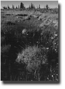
Terminology. A peat-accumulating we tland that has no signific ant inflows or outflows and supports acidophilic mosses, particularly Sph agnum.
|
|
|
- Marcia Taylor
- 5 years ago
- Views:
Transcription

1 Terminology A peat-accumulating we tland that has no signific ant inflows or outflows and supports acidophilic mosses, particularly Sph agnum Bog 1


2 A peat-accumulating wetland that receives some drainage from surro unding mineral soil and usually su pports marsh-like vegetation This differ from bogs because the y are less acidic and have higher n utrient levels. They are therefore a ble to support a much more divers e plant and animal community. Th ese systems are often covered by grasses, sedges, rushes, and wildfl owers Fen Cypripedium reginae, is an exampl e of a unique plant that thrives in this. 2

3 3
")

4 Peatland A generic term of any wetland that accumulate s partially decayed plant matter(peat) What is peat? Partially carbonized vegetable matter, usually mos ses, found in bogs and used as fertilizer and fuel 4

5 Marsh A frequently or continually inundated wetland characterized by emergent herbaceous vegetati on adapted to saturated soil conditions 5

6 Shallow marshlike pond, particularly as found in t he Dakotas and central Canadian provinces. Pothole Prairie Pothloles These are depressional wetlands found most of ten in the Upper Midwest, especially North Da kota, South Dakota, Wisconsin, and Minnesota. This formerly glaciated landscape is pockmark ed with an immense number of potholes, whic h fill with snowmelt and rain in the spring. 6

7 Ombrotrophic peatland Precipitation dominated These are the true raised bogs that have developed peat layers higher than their surroundings and that receive nutrients and other minerals exclusively by precipitation 7
8 Minerotrophic peatland These are true fens that receive water that has pass ed through mineral soil. These peatlands generally have a high groundwater level and occupy a low p oint of relief in a basin. They are also referred to as rheotrophic peatlands. Mesotrophic peatland Nutrients, Minerals Fen Bog ombrotrophic mesotrophic Low PH(Acidic) High PH(less acidic) minerotrophic 8

9 Three Different Types of Wetlands (as they are related to groundwater flow) Wetlands may Receive inputs from groundwater Recharge local groundwater by generating ground water outflow Be part of a flow-through system, receiving groun dwater discharge along an up-gradient boundary an d recharging groundwater along a down-gradient margin 9

10 Dry Wet Season 10
11 Influence of Topographic Settings Aquatic Body (Lake or Wetland) Soil-Moisture Zo ne Tension held capillary water 11

12 Sediments Transport Simulating vertical flow in large peatlands A.S.Reeve, D.I.Siegel, P.H.Glaser 12
 is r elatively impermeable, i solating the uppermost p eat(acrotelm) from the m")
13 Peatland Hydrology The hydrology of peatlands influences landform de velopment by regulating interactions among vegeta tion, nutrient dynamics and carbon fluxes Two conceptualizations of peatland hydrology Shallow flow Groundwater flow Introduction Shallow Flow Model The deeper, more decom posed peat(catotelm) is r elatively impermeable, i solating the uppermost p eat(acrotelm) from the m ineral soil or bedrock. Bogs are supplied with n utrients only by precipita tion because they are top ographically high areas i solated from runoff and groundwater. Fens, in co ntrast, receive solute-lad ened runoff from the sur rounding uplands 13

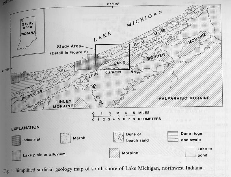
14 Groundwater Flow Model Water-table mounds sustai ned by precipitation from u nder bog domes and drive l ocal ground-water flow cel ls. Dilute water derived from precipitation moves down ward under the bog dome f lushing solutes from the de eper bog peat. Fens are gro undwater discharge zones f or local flow cells and rece ive upwelling minerotrophi c groundwater Acrotelm Upper peat layer Less than 50cm thick Undecomposed peat Peat Landforms Varing oxidation states due to water table fluctuati on High hydraulic conductivity(k) 0.01m/s(~gravel or coarse sand) Rapid water movement 14
15 Catotelm Lies below the acrotelm and above the mineral soil Composed of more humified plant material Lower hydraulic conductivity 10-5 ~10-8 m/s ~ fine sand or silt Continuously saturated and anoxic anoxic lacking of oxigen Darcy s Law? Governing Equation dh Q = KA dl Possible reason for deviations from the Darcy s law Elastic storativity of the peat Trapped biogenic gases in the peat column that affect pore -water flow by occluding pores and lowering hydraulic co nductivity 15
16 Governing Equation K xx 2 h + K 2 x yy 2 h + K 2 y zz 2 h W 2 z = S s h t Grid Discretization and B.C. 16
17 System s behavior to Kms When the K ms is small small vertical gradient vertical flow not significant When the K ms is large high vertical gradient vertical flow significant System s sensitivity to K ms Compare result 1-4 and 2-5 In both cases, regional slope was decreased from to (every other factor was fixed) However, change of gradient value for the first case was larger than that for the second case. 17
18 Compare result 1-3 and 2-4 In both cases, height of the bog dome was decreased from 1.80 to 0.90 However, change of gradient value for the first case was larger than that for the second case. This implies that the system becomes more sen sitive with higher values of K ms Vertical Flow is more active with Lower regional slope This can not be obtained from simply reading and analyzing the table, but can be known from the mo deling result figures. Higher bog mounds 18


19 19


20 20

21 Conclusion Vertical flow is significant when the difference in hydraulic conductivity between mineral soil and overlying peatland is higher Lateral flow dominant when K ms is very low. System is sensitive with higher value of miner al soil s hydraulic conductivity Vertical flow in peatland is more active with Lower regional slope Higher bog mound 21

22 Discussion Is the domain size of this model appropriate? Is boundary condition appropriate? 22
23 Interaction between Groundwater and Wetlands, Southern Shore of Lake Michigan, USA Robert J. Shedlock, Douglas A. Wilcox, Todd A. Thompson and David A. Cohen Introduction 23


24 24


25 25


26 26
27 27


28 Red Mapel Tamarack 28


29 Northern White Cedar Sedge Meadow 29


30 Shrub Zones Cowles Bog 30

31 Hydrogeologic Settings Hydrogeologic Settings 31


32 Field Measurement 32
33 Hydrochemistry of the aquifers: Class I : water in the subaquifer below the Cowles Bog peat mound. Ca 2+, Mg 2+, HCO 3 - Higher in SO 4 2- and low in Na + than subtill aquifer. Class II : water from surficial aquifer, but not on the peat mound. Similar in composition to water below the mound. Proportionally lower Mg 2+ and SO 4 2- concentrations. Class III : water from the surficial aquifer in the dunes. More variable, less alkaline. Hydrochemistry of the aquifers: Peat vs. Sand below Peat There is less difference in chemical coimposition in the peat mound and sand below it. There is more difference beyond the mound. 33
34 34
35 Tritium composition: Pre-radiation levels < 15 pci/l Water below the subtill aquifer : 1-5 pci/l Water in sand below dune : 2-13 pci/l Water in peat at mound : pci/l Water elsewhere : pci/l 1 pci = 1x10-12 Curies Ground-flow patterns: Regional groundwater flow Intermediate groundwater flow Local groundwater flow 35


36 36
 calcium magnesium bicarbonate type (low tritium, high hardne ss, alkalinity and dissolv ed")

37 Much less mineralized calcium sulfate bicarbonate type (high tritium, lower hardness, alkalinity, and dissolved solids concentration) calcium magnesium bicarbonate type (low tritium, high hardne ss, alkalinity and dissolv ed Much less mineralized calcium sulfate bicarbonate type (high tritium, lower hardness, alkalinity, and dissolved solids concentration) calcium magnesium bicarbonate type (low tritium, high hardne ss, alkalinity and dissolv ed solids concentration) 37
38 What to do next? Discussion Are there any additional data which would be helpf ul? Is modeling the next step? What kind of model? Do the authors miss some opportunities to resolve some of the puzzles? Conclusion The nature of groundwater-wetland interaction s underscores the importance of understanding the hydrogeologic setting of an area much larger than that of the wetlands of concern 38

39 39