Enabling Distributed Hydrologic Prediction through Radar Detection of Rainfall
|
|
|
- Marsha Davidson
- 5 years ago
- Views:
Transcription
1 Enabling Distributed Hydrologic Prediction through Radar Detection of Rainfall Baxter E. Vieux Ph.D., P.E. Professor, School of Civil Engineering and Environmental Science, University of Oklahoma Vieux & Associates, Inc. The future? Its already here, just not very evenly distributed. William Gibson Fifty Years of Watershed Modeling - Past, Present and Future, September 24-26, 2012, Boulder, Colorado, USA 1


2 2 Presentation Overview Real-time hydrologic prediction of stormwater provides critical information for management actions Two key technologies: 1. Accurate rainfall rates at high resolution over large areas in realtime, and 2. Predicted stage and flow rates at any location in the drainage network based on hydraulics
3 3 Outline 1. Physics based approach 2. Accurate rainfall rates at high resolution over large areas in real-time Gauge Adjusted Radar Rainfall (GARR) Real-time rainfall systems 3. Distributed hydrologic modeling applications Recent flood forecasting at gaged and ungauged locations


4 4 Hydrologic Prediction Problem Action Level Rainfall Site-specific Forecasts
5 5 Vflo Characteristics Requirements dictated by users needing real-time stormwater and flood stage at specific locations Solves conservation of mass/momentum on a gridded basis Numerical solution finite element/difference Designed to utilize rainfall rates found in radar Continuous soil moisture, Green and Ampt/Saturation Excess Uses geospatial data as input for parameterization 21 st Century development utilizes modern data (geospatial, radar, and xml, kml, Java) Hydraulic approach to Hydrology
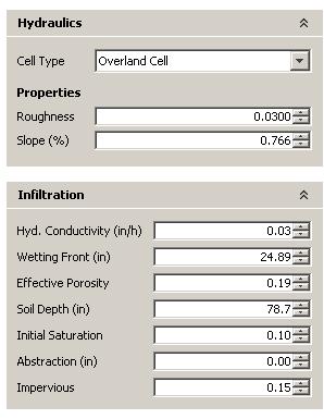
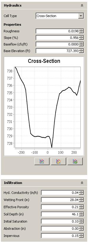
6 6 Model Input/Parameters Rainfall Runon Runon Runoff Runon Infiltration Representative Rainfall Gauge adjusted Radar Rainfall input Physical Characteristics Channel/overland Hydraulic routing in a drainage network composed of grids Soil Infiltration/Impervious Land Cover for hydraulic roughness Continuous Soil Moisture Reservoir Detention Recharge/channel losses
7 7 Physics of Rainfall-runoff What is the solution to the equation governing surface runoff depth, h, as a function of runoff rates, (R-I)? 1/ 2 5/ 3 h So h + = R I t n x How can it be the following? Rainfall Rate - infiltration = (NRCS) Depth


8 Model Equations i e =R-I Conservation of Mass = MomentumS f =S o in each grid Manning, Q=α h m m=5/3, α =κ S 1/2 /n Numerical Solution Dispersion causes attenuation without solving diffusive wave equation Q 0 Q 1 Q 2 h Vieux, B.E., V.F. Bralts, L.J. Segerlind and R.B. Wallace, (1990), "Finite Element Watershed Modeling: One-Dimensional Elements," ASCE, J. of Water Resources Management Planning, Vol. 116, No. 6, November/December, pp


9 Trial Watershed Tutorial 2
10 Kinematic and diffusive waves Kinematic translation No attenuation Attenuation (dispersion) attenuation L=100 m n=0.035, So=3%


11 11 Urban Watershed Setup LiDAR DEM (1m) 30 m Model NOAA SARP Joes Creek, Dallas
12 12 Outline 1. Physics based approach 2. Accurate rainfall rates at high resolution over large areas in real-time Gauge Adjusted Radar Rainfall (GARR) Real-time rainfall systems 3. Distributed hydrologic modeling applications Recent flood forecasting at gaged and ungaged locations


13 13 What is Gauge Adjusted Radar Rainfall? Rain Gauge Radar? Combination of gauge and radar produces better maps of rainfall than either system alone

 Rain rates depend on time rate of arrival")
14 Z = N D o o Radar Measurement Z=250 R 1.2 Z=300 R 1.4 Z=AR b 14 Reflectivity depends on the number of drops and distribution of sizes called the drop size distribution (DSD). Z = N o Do RADAR GAUGE Rainfall Rate (R) Rain rates depend on time rate of arrival of each drop and its size (DSD). R = N o D o / 4026

15 15 Gauge Adjustment of Radar Bias correction factor, F F n 1 n i= 1 = n 1 n i= 1 G R i i Corrected Radar R adj = F R i
16 16 Quantifying GARR Reliability Bias correction and quality control is necessary before NEXRAD data can be used in hydrology, engineering, or modeling of public works projects Vieux, B.E., and J.E. Vieux, Statistical evaluation of a radar rainfall system for sewer system management. J. of Atmospheric Research, 77 pp Radar Data Source = KDIX LII # of gauges used = 11 of 11 Mean Field Bias = Ave Diff (%) = 14.5 Cal Ave Diff (%)= 13.9 Rel Dis (%) = 15.6
 Mean Field Bias Bias Correction Factors, F Unadjusted (+) y = 1.1003x 2 R = 0.")

17 Radar to Stream Gauge Volume 0 Mean field bias factor, F for each 6-hr moving window. Adjusted y = 1.076x 2 R = Radar Rainfall Volume (mm) Mean Field Bias Bias Correction Factors, F Unadjusted (+) y = x 2 R = Jan Apr Jul Oct Jan Apr Jul Oct Jan Apr Jul Oct Jan Stream Gauge Volume2006 (mm) FMR Gi = Ri Fang, Z., A. Zimmer, P.B. Bedient, H. Robinson, J. Christian, and B.E. Vieux. Using a Distributed Hydrologic Model to Evaluate the Location of Urban Development and Flood Control Storage. J. Water Resour. Plng. and Mgmt. 136(5), pp (September/October 2010). 17
18 18 Outline 1. Physics based approach 2. Accurate rainfall rates at high resolution over large areas in real-time Gauge Adjusted Radar Rainfall (GARR) Real-time rainfall systems 3. Distributed hydrologic modeling applications Recent flood forecasting at gauged and ungauged locations

19 Vflo Distributed hydrologic modeling applications City of Austin Flood Early Warning System (FEWS) Real-time operation for km 2 Forecast stage at 200+ locations for predictive inundation 21 Stream gauges Gauge-adjusted radar input Continuous Soil Moisture Rainfall-runoff modeling web services and desktop model Automated notifications XML/KML interface with internal databases Vieux & Associates, Inc. 19 Lake/Rattan Creek 33,398 cells at 75m Setup by FEWS using LiDAR DEM
 Gauge")

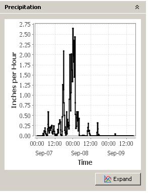
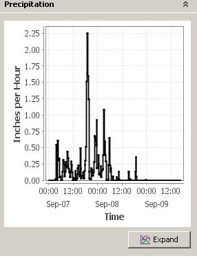
20 TS Hermine ( ) Gauge Adjusted Radar Rainfall Courtesy City of Austin/FEWS


21 Courtesy City of Austin/FEWS

22 Courtesy City of Austin/FEWS

23 Courtesy City of Austin/FEWS

24 Courtesy City of Austin/FEWS

25 First result with TS Hermine Uncalibrated Courtesy City of Austin/FEWS


26 Tropical Storm Hermine Courtesy City of Austin/FEWS 07/07/10 07/09/10 00:00


27 h t + 1/ s βn 2 h 5 / 3 x = γr αi

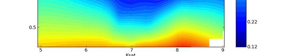
28 GA Calibration Hydraulic Roughness


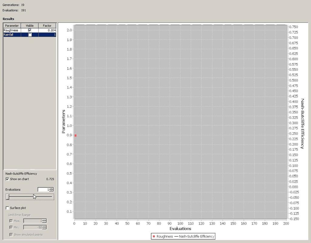
29 TS Hermine Observations at 21 USGS Gauges 29 Peak stage forecasts with radar input: Average Difference (Obs/Sim) = 17.7% (radar/gauge Average Diff = 15.6%)
30 Streamflow Prediction Accuracy GARR versus Gauge-only 30 NSE GARR RGO Median NSE u = 0.80 (radar input) Median NSE u = (gauge only input) Area per rain gauge (sq. km.) Copyright Baxter E. Vieux, University of Looper, J.P. and B.E. Vieux, An assessment of distributed flash flood forecasting accuracy using radar and rain gauge input for a physics-based model. Journal of Hydrology.

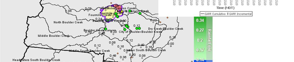

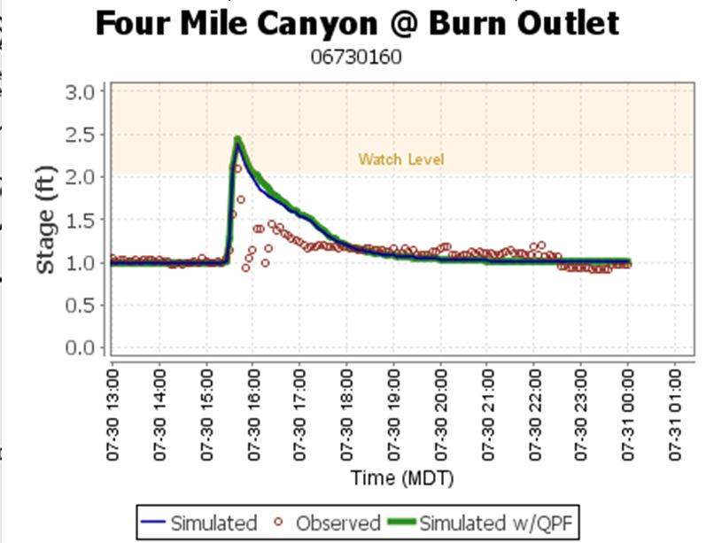
31 Fourmile Burn Area


32 Field Observation of Peak Arrival Fourmile Canyon Broadway, Boulder

33 33 Summary Hydrographs produced from high-resolution rainfall combined with high-resolution geospatial data (LiDAR) = Applications Understanding where runoff is occurring for water quality modeling even in ungauged areas Lead-time for emergency management actions Evaluation of drainage infrastructure performance Watershed models for management decisions and design calibrated to actual storm events
 Bedient, Huber and Vieux, Hydrology and Floodplain Analysis, 5 th Edition (2013) Journal")
34 34 Documentation Vflo online documentation (Wiki type) Desktop Help and Tutorials Publications- B.E. Vieux, Distributed Hydrologic Modeling Using GIS, Springer 2 nd Edition (2004) Bedient, Huber and Vieux, Hydrology and Floodplain Analysis, 5 th Edition (2013) Journal Articles (on request) Journal of Hydrology Journal of Hydrologic Engineering