HISTORY OF CONSTRUCTION 40 CFR (c)(1)(i)-(xii) PLANT MCDONOUGH ASH POND 1 (AP-1) GEORGIA POWER COMPANY
|
|
|
- Brandon Price
- 5 years ago
- Views:
Transcription
1 HISTORY OF CONSTRUCTION 40 CFR (c)(1)(i)-(xii) PLANT MCDONOUGH ASH POND 1 (AP-1) GEORGIA POWER COMPANY (i) Site Name and Ownership Information: Site Name: Site Location: Site Address: Owner: Address: Plant McDonough-Atkinson Atlanta, Georgia 5551 South Cobb Drive SE Atlanta, GA Georgia Power Company 241 Ralph McGill Boulevard Atlanta, GA CCR Impoundment Name: NID ID: Plant McDonough AP-1 NA EPA s Disposal of Coal Combustion Residuals from Electric Utilities Final Rule (40 C.F.R. Part 257 and Part 261), subsection (c)(1), requires the owner or operator of an existing CCR surface impoundment to compile a history of construction. To the extent feasible, the following information is provided: (ii) Location: N, W See Location Map in the Appendix (iii) Purpose of CCR Impoundment: Plant McDonough is a natural gas-fired generating facility that historically operated as a coal fired facility. Plant McDonough historically utilized four (4) ponds in the management of coal combustion residuals. AP- 1 was designed to receive and store coal combustion residuals produced during the coal-fired electric generating process at Plant McDonough. AP-1 is capped with final cover construction completed in Q AP-1 s final cover construction was completed in accordance with 40 C.F.R (d). This closure method has eliminated the future impoundment of water, sediment, or slurry. AP-1 no longer impounds free water nor receives CCR or other waste streams, and is in the process of obtaining a solid waste permit under the Georgia Rules for Solid Waste Management, Therefore, McDonough AP-1 no longer meets the definition of a CCR impoundment.
2 (iv) Watershed Description: Plant McDonough and AP-1 are located within the Proctor Creek-Chattahoochee River HUC-12 watershed which has a total area of 15,229 acres. The Proctor Creek-Chattahoochee River watershed is part of the larger Middle Chattahoochee-Lake Harding HUC-8 watershed which has an area of 1,950,182 acres. The inflow to AP-1 consists of the rainfall that falls within the limits of the surface impoundment, and runoff from approximately 6.8 acres of adjoining land. The drainage area for AP-1 totals 29.7 acres. (v) Description of physical and engineering properties of CCR unit foundation/abutments: AP-1 is located in the northwest part of the Plant McDonough property. The unit is bounded on the west side by commercial use properties, on the north by industrial and residential areas, on the east by Ash Ponds AP-2, AP-3 and AP-4, and on the south by plant infrastructure and the Chattahoochee River. AP-1 is located in the Piedmont geologic region, characterized by igneous and metamorphic bedrock. In general, underlying rock at the facility consists of schist and gneiss with overlying Piedmont soils formed by the in-place weathering of the parent rock referred to as residuum soils. Weathering is generally most advanced near the surface and decreases with depth. This weathering results in a subsurface profile that consists of finer grained soils at the surface where weathering is more advanced (upper residuum), underlain by sandy silts and silty sands (lower residuum). Surficial soils tend to be featureless and of uniform color, typically reddish brown. With depth, soils often retain recognizable relic structure of the parent rock, producing banding or mottling in a wide range of colors, and are called saprolite. The depth to rock surface varies across the site, but rock is generally encountered 20 to 60 feet below ground surface. AP 1 is a combination incised and compacted fill impoundment. The embankment of AP-1, with a height of 34 feet, was formed in the early 1960 s using perimeter dikes on the west, south, and southeast side of AP-1 using locally borrowed, residual compacted soils, consisting of clayey silts, sandy clays and silty clays. Compacted fill was placed above natural ground to the top of dike Elevation 790 ft. Interior slopes for the compacted fill portion of the dike were constructed to 1¾H:1V, while the exterior slopes were constructed to 2H:1V. The crest width was 10 ft. (vi) Summary of Site Preparation and Construction Activities: AP-1 was constructed in the early 1960s, with a total storage capacity of 880,000 cubic yards, and an original pond area of 25 acres, to receive and store CCRs from the coal-fired electric generating process at Plant McDonough, and was used for sluicing operations for all ash types. AP-1 was in service from 1963 until 1968 when Georgia Power ceased placing CCR in AP-1 upon reaching storage capacity. AP-1 was covered with an intermediate closure system and the unit was utilized as a lay down area. Closure activities for AP-1 were initiated in January At the time of this submittal, AP-1 no longer impounds free water nor receives CCR. Construction of the final closure system for AP-1 has been completed in accordance with 40 CFR (d) Closure Performance Standard when Leaving CCR in Place, and AP- 1 is in the process of obtaining a solid waste permit under the Georgia Rules for Solid Waste Management,
3 (vii) Engineering Diagram: Drawings reflecting the construction of AP-1 can be found in the Appendix: 1960 Plan View of Initial Construction 1960 Details of Initial Construction (viii) Description of Instrumentation: Prior to closure construction activities, there were twelve temporary piezometers located within the boundary of AP-1 (AP1-1 through 8, AP1-10 through 13). These piezometers were used to monitor water levels in and around the embankments and have been decommissioned. There is currently no instrumentation located in AP-1. (ix) Area-capacity curves: At the time of this submittal, AP-1 has undergone completion of construction activities for closure in-place and a final cover has been constructed. As a result, AP-1 does not have the capacity for storage of surface water and the presentation of area-capacity curves is not applicable for the current condition. (x) Spillway/Diversion design features and capacity calculations: The original design of AP-1 outlet structure consisted of a drop inlet located at the southern end of the impoundment. The structure was a square concrete, vertical, drop inlet with a 36-inch diameter, corrugated metal pipe. From the outlet structure, water discharged south to the Chattahoochee River via an onsite creek. Historically, there were no open channel spillways at AP-1. At the time of this submittal, AP-1 has undergone closure construction activities for closure in place, does not have the capacity for storage of surface water and therefore has no spillway. (xi) Provisions for surveillance, maintenance and repair: Prior to closure, inspections of dikes are critical components and were conducted on a regular basis at least annually by professional dam safety engineers and at least weekly by trained plant personnel. In addition, inspections were performed after periods of heavy rainfall and storms. The inspections provided assurance that structures were sound and that action was taken, as needed, based on the findings. Weekly inspections include numerous items including pond levels, weather conditions and rainfall since the prior inspection, conditions of slopes and drains, erosion, animal damage, ant hills, alignment of retaining structures and more. During annual inspections, dam safety engineers assessed instrument readings, inspected any maintenance or remediation performed since the previous inspection, checked the status of work recommended at prior inspections, ensured that the posting of emergency notification information was up to date and evaluated any items noted during plant personnel inspections. Construction specifications: No specifications from the original construction of AP-1 could be located. (xii) Known record of structural instability: There is no known record of major structural instability or repairs to the AP-1 impoundment
4 Appendix

5 LOCATION MAP
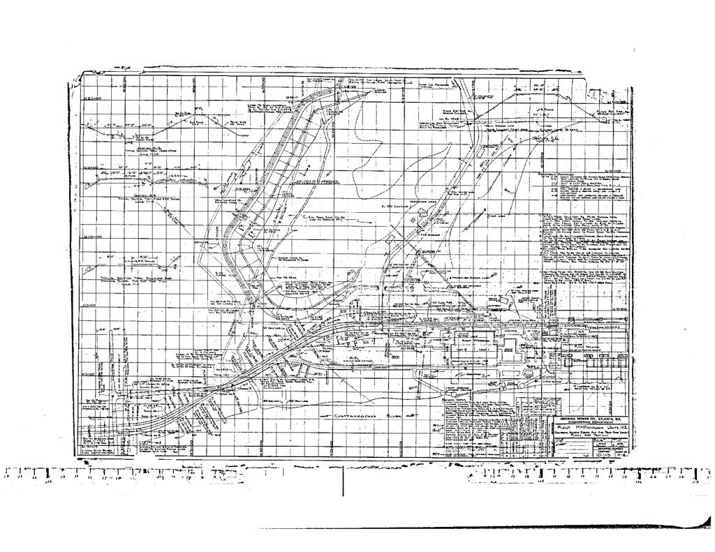
6 DRAWINGS

7