STREAMBANK STABILIZATION: POST CONSTRUCTION MITIGATION MONITORING REPORT (YEAR 4 OF
|
|
|
- Leona Whitehead
- 5 years ago
- Views:
Transcription

 July")

1 STREAMBANK STABILIZATION: POST CONSTRUCTION MITIGATION MONITORING REPORT (YEAR 4 OF 5) July 2008 Contract Number PG CABIN BRANCH POTOMAC CROSSING CONSULTANTS
2 TABLE OF CONTENTS Executive Summary Introduction Methods Results Stabilization Integrity Conclusions... 5 LIST OF FIGURES Figure 1 - Vicinity Map... 2 Figure 2 - Restoration Site Location Map... 3 APPENDICES Appendix A Photographs Appendix B Visual Assessment Forms
3 EXECUTIVE SUMMARY Post Construction Mitigation Monitoring for the Woodrow Wilson Bridge Stream Restoration project was conducted in May 2008 at Cabin Branch (CB 8 & 9). This report represents the fourth year of monitoring data for the five year monitoring program. Monitoring was conducted in accordance with post construction monitoring requirements detailed in the Conceptual Compensatory Aquatic Resources Mitigation and Monitoring Plan. Permit requirements and special conditions contained in the US Army Corps of Engineers permit CENAB-OP-RMN , MDE Nontidal Wetlands and Waterways permit 99-NT-0578/ and MDE Water Quality Certification were also considered in the development of field monitoring protocols. The primary purpose of the monitoring is to determine if the performance standards set out in the permit are being achieved at the constructed site. In order to provide a more efficient post-construction monitoring method, the assessment protocol was modified in April A visual assessment of stream structures and conditions was conducted on May 13, The structures and streambed are stable, and the stream is functioning in accordance with mitigation goals. Grasses and shrubs planted within the limits of disturbance appear robust; however, wild grape is dominating upland areas along the right bank. Rapid spread of wild grape is a threat to trees and shrubs established as part of the mitigation project.
4 1.0 INTRODUCTION The Maryland State Highway Administration (SHA) Contract Number PG (Cabin Branch Stream Mitigation) received Notice to Proceed on July 1, This contract was one of seven SHA contracts that were funded solely for environmental mitigation purposes to offset unavoidable water quality impacts associated with the reconstruction of the Woodrow Wilson Bridge and the improvements to the MD 210 and I- 295 interchanges. This report presents the fourth year of mitigation monitoring at Cabin Branch and it is the fourth of five post construction monitoring reports submitted for this contract. The previous reports entitled Stream Stabilization: Post Construction Mitigation Monitoring Report present monitoring results for the first three years following construction of the Cabin Branch stream stabilization project. The environmental mitigation program developed for the Woodrow Wilson Bridge Project is outlined in Appendix B of the Woodrow Wilson Bridge Project s Final Supplemental Environmental Impact Statement/Section 4f Evaluation (FSEIS), dated April 14, Appendix B of the FSEIS contains the Conceptual Compensatory Aquatic Resources Mitigation and Monitoring Plan (CMMP) which details the specifics of the mitigation plan and the post construction monitoring requirements that are being used to evaluate the success of the completed mitigation projects. In addition to the monitoring protocols outlined in the CMMP, permit requirements and special conditions contained in the US Army Corps of Engineers permit CENAB-OP-RMN (July 27, 2000) and MDE Nontidal Wetlands and Waterways permit 99-NT- 0578/ (July 26, 2000), and MDE Water Quality Certification (June 7, 2000) were considered in the development of field monitoring protocols. Two cross sections were established and surveyed in April 2002, prior to the beginning of construction. The cross sections were intended to be used as a baseline for comparison during post-construction monitoring. The Cabin Branch project was completed in October In September 2003 Hurricane Isabel caused modest slope failures and tree falls. A redline remediation plan consisting of log and stone toe protection was implemented in October The first year of post construction monitoring was conducted in Spring The goal of the Cabin Branch stream restoration project is to stabilize an 825-foot reach of Cabin Branch to improve habitat and water quality. The stream suffered from modified hydrology and subsequent bed and bank destabilization resulting from urbanization. In an attempt to prevent further vertical and lateral degradation, the project incorporated the following features: 1) cross vanes for streambed grade control, 2) stone toe protection and bio-engineering for bank stabilization, and 3) rock vanes and channel modification for aquatic enhancement. Secondary goals included the re-introduction of native vegetation for upland enhancement and park improvement. 1

5 Cabin Branch Site WOODROW WILSON BRIDGE PROJECT Cabin Branch Bank Stabilization VICINITY MAP FIGURE 1 Not to Scale 2
6 FIGURE 2 CB-1 Restoration Site Location Map
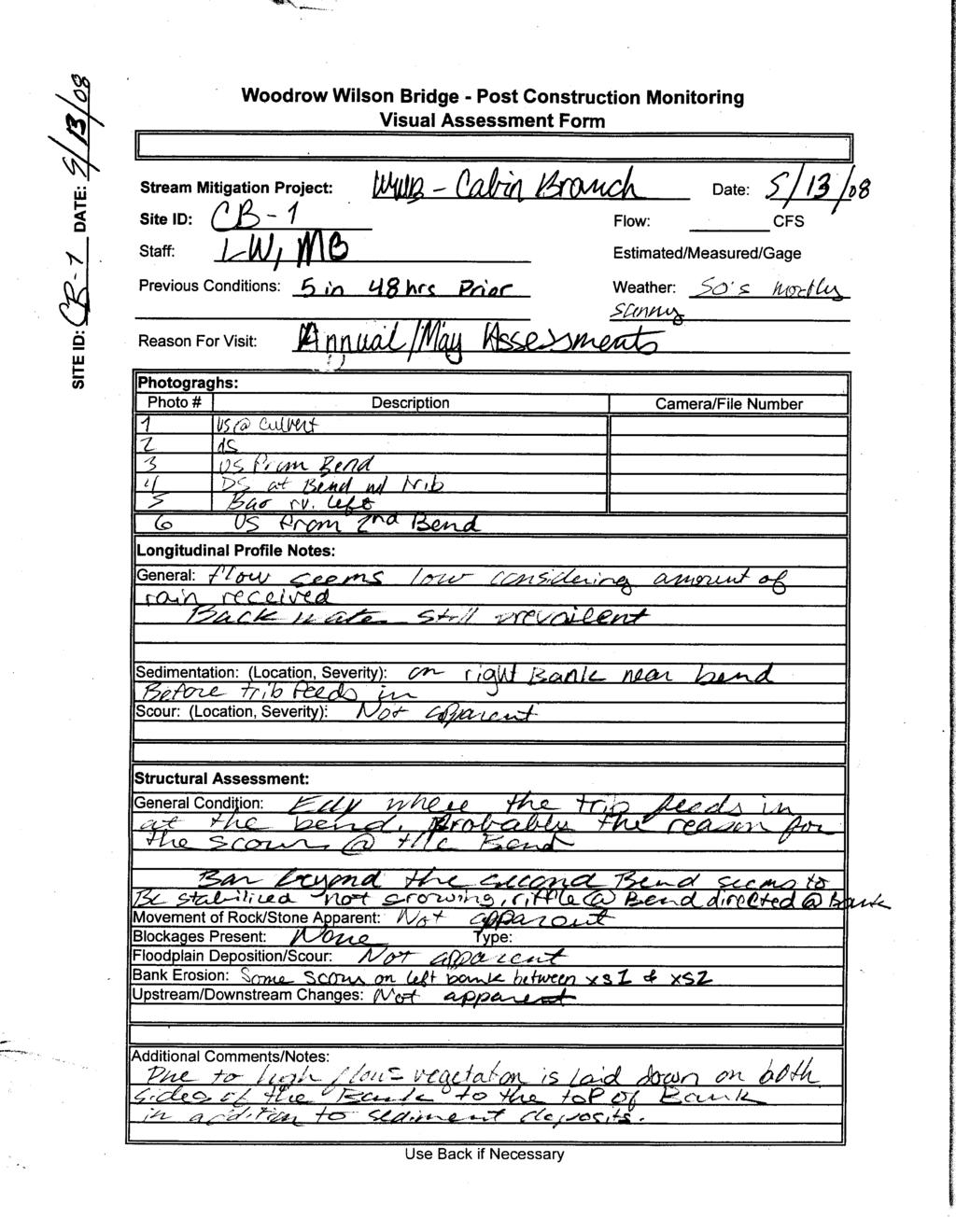
7 Fourth year post-construction monitoring was performed on May 13, The primary purpose of monitoring the restoration project is to evaluate bank and streambed stability in accordance with the modified monitoring protocol described in the following section. 2.0 METHODS Structures installed as stabilization features included two cross vanes, a rock vane and stone toe and bank protection on outside meanders. Typically, four to five cross sections and a longitudinal profile are surveyed each year for post construction monitoring activities. While this generated useful data during the first few years after construction of the project, the project team decided that a revised methodology incorporating a visual assessment with photo documentation could be used to evaluate the stability of the mitigation project. This visual assessment includes documentation of structure stability, sedimentation, debris blockages, apparent water quality issues, erosion and/or scour. Under the revised approach, a structural survey will be undertaken if it is determined through the visual assessments that performance criteria are not being achieved, a noticeable change in the physical dimensions of a structure has occurred, and/or if significant scour or sedimentation is observed. Monitoring will continue at Cabin Branch for one more year. Routine visual assessments will continue to be done monthly and/or after significant storm events. Photos will continue to be taken from the designated photo stations for documentation during visual assessments and inclusion in the annual report. In order to provide a long-term basis for comparison, the final year of monitoring in 2009 will include a longitudinal profile and cross-sections. 3.0 RESULTS Stabilization Integrity The stabilization structures are functioning as designed, based on the May 13, 2008 visual assessment conducted within the project area. No significant erosion, scour, blockages or deposition appear to be threatening structures. Observations showed that the stream bed is stable and that erosion and depositional features are consistent with a channel reaching a state of equilibrium following a disturbance, such as the stabilization project. Grasses and shrubs are well established. Trees appear healthy; however, wild grape is dominating the upland vegetation, and could threaten trees planted for riparian enhancements. Photographs and the visual assessment field form are available in Appendix A and Appendix B, respectively. 4
8 4.0 CONCLUSIONS The stream stabilization project completed at Cabin Branch in 2004 remains stable and is meeting design criteria, based on the Spring 2008 monitoring. The site will continue to be monitored over the next year in order to document conditions related to the structural integrity of the cross vanes, rock vane, bank stabilization rip rap, and the channel bed. No remediation of the channel or structures is needed at this time. 5
9 APPENDIX A- Photographs


10 Appendix B - Cabin Branch Photos 2008 Cabin Branch looking downstream from top of project Cabin Branch looking downstream at backwatered crossvane
11 APPENDIX B- Visual Assessment Forms
12

13
14
15