Training on Roads for Water and Resilience
|
|
|
- Jonathan McDowell
- 5 years ago
- Views:
Transcription
1 Training on Roads for Water and Resilience

2 ROADS AND FLOODS
3 Floods have costs and benefits Costs: damage to infrastructure and houses, lost lives and crops Benefits: sedimentation provides fertile lands, flushing of stagnant water and pollutants and opportunities for flood based farming, distribution of moisture Goal: to adapt to the constrains that floods impose and take advantage of their benefits
4 Interactions between roads and floods 1. Roads to control or compartimentalize floods Road embankements as dikes 2. Roads evacuating people during floods 3. Roads embankment when reinforced reservoir dam storing floods 4. Roads in flood plain areas (like Gambela)>>>>
5 Flood plains General what we need to understand: Inundated in flood season Different rise and recession patterns: > different livelihood systems Dry period: > different livelihood systems and activities

6 CAMBODIA MEKONG INTENSIVE CULTIVATION AND FISHERY

7 MALI (MOPTI) NIGER RIVER FLOOD PLAINS = LESS INTENSIVE USE

8 SOUTH SUDAN TOIC GRAZING LAND ON RECEEDING FLOOD

9 OMO ETHIOPIA LIMITED CULTIVATION

10 OMO DRY SEASON CULTIVATION

11 Need to understand: Flooding pattern Livelihood systems in wet and dry season: Pastoralist Agriculturalist Fishery

12 Flood plains in SSA > 30 M ha Needs special guidelines and approaches for roads and water
13 Impact of roads in flood plains Flood plains are wide and flat Roads fragment habitats and influence the flow of water, sediments, nutrients and aquatic life in wet season Roads impact dry season activities by water storage and moisture availability (links to burning of grazing land) Roads can effect the gradient of local streams and cause them to silt up Roads in flood plains are in high danger of damage and disruption of traffic
14

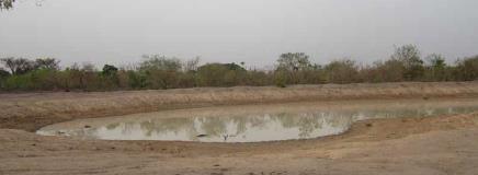
15 SOUTH SUDAN DRY SEASON IRRIGATION FROM BORROW PITS
16 BURNING OF PASTURE LAND RELATED TO TIMELY DRYING OF LAND AFTER FLOOD SEASON
17 Roads in flood plain two approaches Resistance approach Resilience approach

18 Resistance vs resilience strategies Resistance strategy: embankments and roads are constructed to protect areas from the influence of floods Disadvantages: o o o pressure on the structure can cause damage and high maintenance costs floodplain hydraulics are disrupted, which negatively impacts on the floodplain ecosystem water quality problems because dirt and polluted water are no longer removed by the flood waters

19 Resistance vs resilience strategies Resilience strategy: minimizing the negative consequences of floods, but at the same maintain the positive natural floodplain dynamics as much as possible. Might require better understanding and investment, but longer term costs in terms of road damage and ecological impacts will be lower. Important to locate bridges and culverts at the best possible locations and recommend solutions that have only small additional construction costs. Preferable in low intensity flood plains
20 Approach Pros Resistance strategy Better protection against floods Reduction damage in high density areas Cons Fragmentation of floodplains and hydraulic changes and impact on flood-related functions Downstream impacts More expensive to protect roads against damage Resilience strategy Less fragmentation Costs due to construction floodplains and hydraulic through-flow structures changes Reduced access (lower Contribute to preserving roads) and optimizing More need for integrated production systems and planning and management ecological services
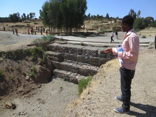
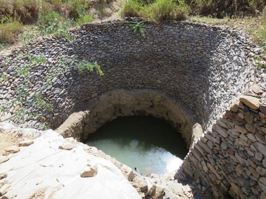
21 Roads in floodplains ConstructionMaintenance Drainage characteristics Erosion/interception Water Harvesting susceptibility potential Elevated subgrades and embankments can increase costs as construction material in floodplains can be scarce. Laminar flows through floodplains require wide drainage systems, flood control mechanisms such as flap gates or (controlled) surface drainage outlets. Waterlogging on buffer areas between road embankments and floodplain. Flood interception less moisture (sediments) on downstream areas. This can have major impact on flood plain agriculture but can also be reversed by controlled drainage through roads Shallow groundwater hand dug wells and manual drilled boreholes (if there are sendy layers) as well as dugout ponds and reused borrow pits

22 Example of resilience approach: Room for the River (The Netherlands) Creates safety against extreme river floods by widening river cross sections to lower flood levels. Situating the dikes further away from the river, or lowering the river forelands, to reduce velocities and water levels by providing space for the watercourse. Requires properly designed flowthrough structures that can withstand the high flow velocities.
23 Design: Roads as flood control mechanisms Roads subgrades and embankments act as dikes, many roads in different countries are laid on the top of dikes. In areas prone to periodical floods roads may serve as flood regulators. Roads laid in floodplains often block flood flow fronts diminishing flood areas. This scenario could be reverted and road design principles are modified. Road may be open to flood flows enabling flood corridors including bridges and long culverts, flap gates and fusing sluice gates. Thus roads can act as flood regulators, controlling flood and drainage patterns.

24 Road design in flood plains Planning and design should take into account the local flood flow patterns Assess the existing hydraulic behaviour of drainage paths, waterways and floodplains, with particular reference to known and potential flood levels in the vicinity of the road alternatives. Identify and assess the potential short- and long-term impacts of construction and operation on the quantity and quality of surface runoff, floodplain inundation and waterway water quality. Damage to rural road by flood
25 Recommendations: road embankment The recommended crest level for National and Provincial roads is the highest recorded flood level plus 0.5 meters. For regional roads the crest level should correspond with a minimum height of the water level of floods with a recurrence of 10 years plus 0.25 meters. For road embankments up to 4 meters high a slope gradient of 1:3 provides sufficient safety protection against the macroinstability mechanism during the rise and fall of the water level. Investigate the geotechnical characteristics of the top soils and take adequate measures in road design, for example removal of inappropriate top soils.
26 Continued. For the National and major Provincial roads slope protection is preferred using gabion mats or stone covers when the hydraulic studies indicate flow velocities exceeding 0.7 m/s and the soil conditions are vulnerable to erosion. Use vegetation hedges to prevent wave erosion of the upper part of the embankment slope and shoulder Main roads to be provided with ashphalts. Regional roads are recommended to be covered with minimum of coarse gravel on a draining (convex) clay substrate

27
28 Reference document MRC Flood Management and Mitigation Programme, Component 2: Structural Measures and Flood Proofing Delft Cluster-WWF-MRC 'Roads and Floods' project Roads and Floods Synthesis Report iv 20 October 2009
29 Recommendations for flow through structures The number and dimensions of flow though openings (bridges and culverts) should be such that interference with the natural hydraulics of the (sub) floodplain in terms of extent (flooded area) and duration is minimal. Less flow structures increases veloctity (and scour) in remaining ones there is a cost factor to increase the number of bridges and culverts so scour protection to bridges and culverts becomes important Where relevant, make sure the road does not obstruct fish migration routes - culverts have relatively small openings and are less suitable to maintain the fish migration
30 Conclusions Road developments in a floodplain system, require a different approach to planning and technical design, compared to road developments in areas that are not (regularly) inundated Need for special standards and guidelines and inclusion of the specifics of developing roads in a dynamic floodplain system Search for a win-win solution where robust technical designs lead to benefits for various construction cost, infrastructure maintenance, ecology, natural resources and vulnerability of population.


31 Supported by: Developed by: