Regional Travel Demand Model (RTDM) Technical Documentation Association of Monterey Bay Area Governments (AMBAG) 1. Introduction:
|
|
|
- Ophelia Edith O’Connor’
- 5 years ago
- Views:
Transcription
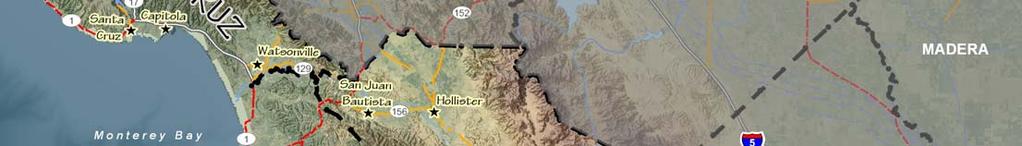
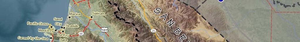
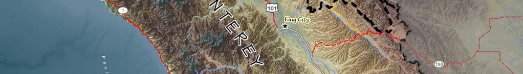
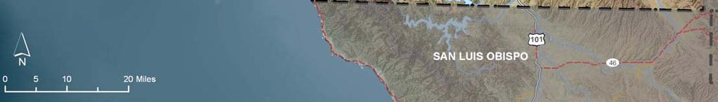
1 Regional Travel Demand Model (RTDM) Technical Documentation Association of Monterey Bay Area Governments (AMBAG) 1. Introduction: The Association of Monterey Bay Area Governments (AMBAG is the federally designated tri-county (Monterey, San Benito and Santa Cruz County) Metropolitan Planning Organization (MPO). To carry out metropolitan transportation planning activities as well as SB375 implementation and development of the Sustainable Community Strategies (SCS), AMBAG works closely with the Santa Cruz County Regional Transportation Commission (SCCRTC), the Transportation Agency for Monterey County (TAMC), the Council of San Benito County Governments (SBtCOG), the Monterey Bay Unified Air Pollution Control District (MBUAPCD), Monterey-Salinas Transit (MST), the Santa Cruz Metropolitan Transit District (SCMTD), California Department of Transportation (Caltrans) and all local jurisdictions (18 cities and 3 counties) within the tri-county Monterey Bay Metropolitan Planning Region. To support the metropolitan transportation planning activities and decision making process AMBAG staff develops, maintains and applies a Regional Travel Demand Model (RTDM). 2. Purpose of the Peer Review: The primary purpose to conduct the TMIP peer review is to evaluate the current AMBAG RTDM, as a means of soliciting: External guidance on current model s functionalities, Identification of possible model deficiencies, Recommendations for AMBAG s Model Improvement Plan (MIP), Experienced advice on model development and applications, and; Expert opinion for resource needs (surveys/other data, technical, financial as well as timing). 3. Monterey Bay Region: The Monterey Bay Metropolitan Planning Region as shown in the Figure 1 is situated between Silicon Valley (San Francisco Bay Area) to the north and San Luis Obispo County to the south in California's North Central Coast area. AMBAG RTDM Land use data summary County AMBAG Variable Year Monterey San Benito Santa Cruz Region Total Housing Units ,338 17, , , ,082 29, , ,077 Population ,632 57, , , ,362 94, , ,714 Employment ,110 16, , , ,460 21, , ,620
2 Figure 1: Location Map - Monterey Bay Metropolitan Planning Region There are 740,048 people residing in this 3.3 million acre AMBAG region. Nearly half a million people live in the 18 cities (only 65,000 acres in total). In 2035 the population is expected to reach 920,714 and an average density of 179 people per square mile. In 2005 there were 257,848 housing units in the region, with an average household size of 3.1 people. In 2035 there will be an additional 69,229 housing units, bringing the regional total to 327,077, with an average household size of 3.0 people. The main demographic challenge is, the region population is aging and staying closer to the coast. 4. The AMBAG Regional Travel Demand Model (RTDM): Timeline The Association of Monterey Bay Area Governments (AMBAG) maintains a travel demand model for use in the three-county region of Santa Cruz, Monterey and San Benito counties utilizing TransCAD software. In this most recent version of the AMBAG model, the coverage area has been expanded to include all of Santa Clara County. (Figure 2: AMBAG model coverage area).


3 Figure 2: AMBAG model coverage area

4 Following is the timeline for the development of the AMBAG Regional Travel Demand Model (RTDM) since 1990; I. First generation MUTP AMBAG Regional Travel Demand Model (TRDM) was developed in 1990s. No detail transportation network and without sophisticated mode choice model. The model base year was 1990 and forecast year II. Fully integrated 4 steps conventional GIS based AMBAG RTDM was developed during The model base year was 2000 and forecast year The model includes detailed transportation and transit networks as well as Nested Logit, mode choice model. The model was calibrated using 2000 California households travel survey results, screenlines traffic counts data and Highway Performance Monitoring System (HPMS) generated Vehicle Miles Travel (VMT) data. This model was used for the development of the AMBAG s 2005 Metropolitan Transportation Plan (MTP). Due to lack of transit boarding data and other constraints, the transit assignments functionality of the model was not developed. III. The current AMBAG-RTDM is updated for the 2005 base year and 2035 forecast year (TransCAD 5.0 platform). This version of the AMBAG RTDM was used to develop 2010 MTP. The transit assignments modeling capabilities and updated mode choice Model is under development. Draft results with other technical details are included in the Appendix 1(will be provided in the week of March 21, 2011). IV. The model also adds 5Ds spreadsheet based postprocessor tool to evaluate the impact of various smart growth/ mixed land use strategies on Vehicle Trips (VT) and Vehicle Miles Travel (VMT) reduction. The technical document for 5Ds tool is attached for peer review (Appendix 2).
5 5. Plans for Model Improvement: AMBAG Model Improvement Plan (MIP) AMBAG has developed the draft AMBAG Model Improvement Plan (Figure: 3), emphasizing the development of integrated land use and transportation models with various customized modeling and visualization tools to analyze the impact of specific development (residential, commercial, industrial and mixed-use developments) and their impacts on Vehicle Miles Travel (VMT) and resultant Greenhouse Gas (GHG) emissions. AMBAG and the three Regional Transportation Planning Agencies (RTPAs) for Monterey, San Benito and Santa Cruz Counties use the AMBAG RTDM in the development of the MTP/RTPs as well as other land use and traffic impact studies. It is expected that, the proposed AMBAG-MIP will provide great support in developing and planning for Sustainable Communities Strategies (SCS) throughout the Monterey Bay region. The proposed AMBAG MIP is designed to enhance the AMBAG s modeling capabilities to accomplish SB 375 requirements. The AMBAG MIP is consistent with the California Transportation Commission s (CTC) Regional Transportation Plan (RTP) guidelines and an integral part of the AMBAG s ongoing model improvement program to meet the MPO s transportation planning requirements. (Appendix 3, to view/download the RTP guideline, please use below web link, Chapter 3 of the document is for modeling requirements) 1_Technical_Change.pdf, or Following are the main priorities as identified in the proposed AMBAG-MIP: 1. Data acquisition, monitoring and forecasting for the Integrated Land use and Transportation model 2. Development of a parcel based land use forecast model that integrates with the regional travel demand model (RTDM) 3. Improvements to transportation models for various application as well as sensitivity test to various policy directives/issue 4. Development of a sketch planning tools for public outreach 5. Feasibility of future generation of model (Activity / tour base travel demand model)
6
7 6. Points for the Peer Review Group: AMBAG's overall goal for the Model improvement and motivation for seeking a TMIP peer review is to continuously maintain and apply a model that is representative of the state of the practice in travel demand forecasting and equip the AMBAG staff, its policy board, RTPAs and local jurisdictions, the support that is needed for their land use and transportation planning needs. Following questions that the MPO and other regional/local agency staff would like to have answered through this peer review: Does current AMBAG model need additional improvements to meet the FHWA/FTA as well as State standards? Are additional improvements needed to the current feedback loop procedures? Are there better techniques for handling trip generation and trip distribution for the size and diversity of our region? Are there checks/balances that we are not performing that should be performed? Is the current trip distribution model (gamma function) is acceptable or use the friction factors tables? How can our mode choice model considering the region s diversity be improved? How can our model keep up with time-of-day requirements since the region has strong influence of SF Bay/San Jose area as well as longer commute distance/time? How can we better reflect the commute pattern between SF Bay Area and AMBAG region? Assessment of the reasonableness of HOV/toll traffic forecasting capabilities What are ways that the AMBAG s regional model can be improved to better answer questions related to Smart Growth /mixed land use development and resultant Greenhouse Gases (GHG) reduction? How can the effects of gas prices or parking cost be better implemented into the agency's model stream? Do peak spreading and induced travel need to be emphasized more? If so, how? What recommendations are there for improving the current demographic allocation tool or for pursuing a new land-use forecasting model for alternative growth scenario testing as well as its integration to the future generation of the travel demand forecasting model? What processes are we using that might not be best practices in travel demand modeling? Are there improvements that could be implemented immediately with limited funds or implemented in a two to three year period for an overall model development? How can we model weekend tourist/visitors activities? How can we model farm workers travel behavior since they are transient (field to field) and seasonal?
8 Where should we obtain base year employment data? What do other MPOs use? How much and at what level field data collection is necessary to build the best practice robust Regional Model? How can we model regional diversities (Socio-economic as well as transit services)? Should we be continuing building a regional travel demand models for all three counties and also include the neighboring region? Or also develop sub-area model? Considering the SB375 requirements as well as other agency needs AMBAG has designed the Model Improvement Plan (MIP). What staffing and funding needs or MPO only develops basic regional model to meet FHWA/FTA s basic requirements and some enhancements are expected to build by just end users? Any organizational changes that can facilitate our model development process more seamlessly? Should we start developing a freight model? If so, how? Should we consider transitioning into an activity-based or tour-based model? If so, should we maintain parallel tracks of modeling? Also associated cost? Should we consider a micro simulation model and how can our current model assist with that implementation? Is there any visualization techniques (sketch planning tool) available for better communications to the board and general public (education materials, flyer for dummy) pertaining to the model methodology and results?