VTA S BART SILICON VALLEY PHASE II EXTENSION PROJECT LOCATION HYDRAULIC STUDY
|
|
|
- David Eaton
- 5 years ago
- Views:
Transcription
1 VTA S BART SILICON VALLEY PHASE II EXTENSION PROJECT LOCATION HYDRAULIC STUDY P R E P A R E D F O R : Santa Clara Valley Transportation Authority U.S. Department of Transportation Federal Transit Administration P R E P A R E D B Y : WRECO 1000 Broadway, Suite 415 Oakland, CA November 2017
2 WRECO VTA s BART Silicon Valley Phase II Extension Project Location Hydraulic Study. November. San Jose, CA. Prepared for the Santa Clara Valley Transportation Authority, San Jose, CA, and the Federal Transit Administration, Washington, D.C.
3 E.1 Introduction Errata This Errata reflects the modifications to the Phase II Extension Project Location Hydraulic Study that may have resulted from comments received during the public review of the Supplemental Environmental Impact Statement (SEIS) and Subsequent Environmental Impact Report (SEIR) for the BART Silicon Valley Phase II Extension (Phase II) Project or that were required for purposes of clarifications. Changes to the Location Hydraulic Study shown in strikeout text for deletions and in underline text for additions. These modifications do not alter the conclusions of the environmental analysis such that new significant environmental impacts have been identified, nor do they constitute significant new information. The modifications are provided by chapter and indicated with the page number from the Location Hydraulic Study that they would replace. This Errata is intended to be used in conjunction with the Location Hydraulic Study. E.2 Chapter/Section Changes E.2.1 Global Changes to the Study Two station names from the Phase I Extension have been renamed: Berryessa Station (or Berryessa BART Station) is now Berryessa/North San Jose Station. Milpitas BART Station is officially the Milpitas Station. E.2.2 Changes to the Summary Page ES-1 E.2.3 The FIRMs further categorize these areas into different Special Flood Hazard Areas (SFHA) or base floodplain and zones AE, AO, A, AH, and Zones D, X (shaded) and X (unshaded) were all found within the Phase II Project limits. Zone AO represents areas with a 1% chance of shallow flooding, with specified flood depths of 1 to 3 ft usually in areas of ponding (BFE determined). By the FEMA definition, Zone D is not considered a SFHA base floodplain. Changes to Chapter 1, Project Description The revised Chapter 1, Project Description, is provided at the end of this Errata. Location Hydraulic Study E-1 November 2017
4 Santa Clara Valley Transportation Authority Errata E.2.4 Changes to Chapter 2, Affected Environment Page 2-4, Section 2.2 The FIRMs further categorize these areas into different SFHA or base floodplain and zones AE, AO, A, AH,, and Zones D, X (shaded) and X (unshaded) were all found within the Phase II Project limits. Zone AO represents areas with a 1% chance of shallow flooding (usually sheet flow on sloping terrain), with specified flood depths of 1 to 3 ft feet of ponding (Base Flood Elevations determined). Page 2-5, Section 2.2 By the FEMA definition Zone D is not considered a Special Flood Hazard Area (SFHA) base floodplain. Page 2-6, Section The Santa Clara Valley Water District (SCVWD), in cooperation with the Natural Resources Conservation Service and the Guadalupe Coyote Resource Conservation District, proposed an approximately 4.4 mile long section of Lower Silver Creek between its confluence with Coyote Creek and Lake Cunningham to provide flood protection from a 1% annual chance event. The construction for Reach 1 through Reach 3 of this sixreach flood control project was completed in A Hydrologic Engineering Centers River Analysis System (HEC-RAS) model was developed by the SCVWD in 2003 for the improvement in progress condition of Lower Silver Creek between Coyote Creek and I-680. The model results indicated that the 100-year discharge in Lower Silver Creek is contained within the creek channel (Earth Tech, 2003). Therefore, the area northeast of the US 101/Lower Silver Creek crossing is no longer within a floodplain. However, the area south of the Lower Silver Creek remains within the base floodplain because this area is within the commingled floodplain of both Lower Silver Creek and Coyote Creek. The proposed project remains within the base floodplain and will have to comply with the San Jose floodplain ordinance. Upon completion of all 6 reaches and Lake Cunningham, SCVWD and the City of San Jose will be able to demonstrate to FEMA that all homes and businesses subject to the 1% annual chance flood from Lower Silver Creek have been protected. Work on Reaches 4-6 are on-going and according to SCVWD will run through December Page 2-12, Section Figure 7 has been updated and is included on page E-4 below. Location Hydraulic Study E-2 November 2017
5 Santa Clara Valley Transportation Authority Errata E.2.5 Changes to Chapter 3, Floodplain Impacts Evaluation Page 3-5, Section Section C of the Special Flood Hazard Area Regulations contained in the City of San Jose Municipal Code and Santa Clara County Ordinance No. NS specify that no new construction or development within an SFHA a base floodplain may cause an increase of more than 1 foot in the base flood WSE when combined with all other existing and anticipated development. Page 3-6, Section The Downtown San Jose West Option Station campus is located within a Zone D where flooding is undetermined but possible, and is not considered an SFHA or a base floodplain. Page 3-7, Section The Project would add approximately 0.77 acres of AIA to the floodplain area and will comply with the San Jose floodplain ordinance. In accordance with the San Jose floodplain ordinance within Zones AH and AO adequate drainage paths around the structures to guide floodwaters around and away from the structure will be proposed. The same minimization measures proposed for Alum Rock Station should be proposed for the Alum Rock Planned Development, and these include minimizing fill in the floodplain, maintaining flood storage capacity and proposing that the floor elevation of all proposed buildings be above the BFE of 89 feet (NAVD) as stated in the San Jose floodplain ordinance. Page 3-8, Section The Downtown San Jose West Option Station campus is located within Zone D where flooding is undetermined but possible, and is not considered an SFHA or a base floodplain. Location Hydraulic Study E-3 November 2017
 Location Hydraulic Study E-4")
6 Santa Clara Valley Transportation Authority Errata Figure 7. Floodplain Map, Part 4 of 4 (revised) Location Hydraulic Study E-4 November 2017
7 Project Description The Phase II Project consists of an approximately six-mile extension of the BART system from the terminus of VTA s BART Silicon Valley Berryessa Extension Project (Phase I) from San Jose to Santa Clara (see Figure 1). Phase I is currently under construction and scheduled to be operational in late The Phase II Project would include approximately five miles of subway tunnel from Berryessa/North San Jose Station, continuing through downtown San Jose, and terminating at grade near the Santa Clara Caltrain Station (see Figure 2). In addition, four passenger stations are proposed. Passenger service on the Phase II Project is scheduled to begin in 2025/2026. There are two construction methods proposed for the five-mile-long tunnel portion of the BART extension the Twin-Bore and Single-Bore Options between the East and West Tunnel Portals. Under the Twin-Bore Option, two twin-bore tunnels would be excavated with one track in each. Each tunnel bore would have an outer diameter of approximately 20 feet. The depth of the tunnel would be between 10 and 75 feet below ground surface. The crown, or top, of the tunnel of the Twin-Bore Option would be, on average, 40 feet below the surface. Under the Single-Bore Option, one large-diameter tunnel bore would be excavated, which would contain both northbound and southbound tracks. The tunnel bore would have an outer diameter of approximately 45 feet. The crown, or top, of the tunnel of the Single-Bore Option would be, on average, 70 feet below the surface. Alignment and Station Features by City City of San Jose Connection to Phase I Berryessa Extension The BART extension would begin where the Phase I tail tracks end. The at-grade Phase I tail tracks would be partially removed to allow for construction of the bored tunnels, East Tunnel Portal, and supporting facilities. The alignment would transition from a retained-fill configuration east of U.S. 101 and south of Mabury Road near the end of the Phase I alignment into a retained-cut configuration and enter the East Tunnel Portal nearjust north of Las Plumas Avenue. South of the portal, the alignment would pass beneath North Marburg Way, then approximately 25 feet below the creek bed of Lower Silver Creek for the Twin-Bore Option, or approximately 30 feet for the Single-Bore Option, just to the east of U.S. 101, then curve under U.S. 101 south of the McKee Road overpass, and enter Alum Rock/28 th Street Station. Location Hydraulic Study 1-1 November 2017
8 MARIN Berkeley 24 Walnut Creek Embarcadero San Francisco SAN FRANCISCO COUNTY Glen Park Balboa Park Daly City Daly City Colma 101 South San Francisco Montgomery St Powell St Civic Center/UN Plaza 16th St Mission 24th St Mission 80 West Oakland Oakland Alameda MacArthur CONTRA 19th St Oakland COSTA COUNTY 12th St Oakland City Center Lake Merritt Fruitvale Coliseum/Oakland Airport San Leandro Bay Fair San Leandro Legend Project Corridor Existing BART System Berryessa Extension* Warm Springs Extension** BART Station * Under Construction ** Opened since release of the Draft SEIS/SEIR Miles 1 San Bruno San Francisco International Airport Hayward Castro Valley Millbrae San Mateo 92 Hayward South Hayward Union City ALAMEDA COUNTY Redwood City 84 Fremont Fremont 35 Warm Springs SAN MATEO COUNTY Palo Alto Los Altos Mountain View Milpitas 1 Sacramento San Francisco Monterey Project Location SANTA CLARA COUNTY Sunnyvale Santa Clara Santa Clara 280 Diridon San José Berryessa Alum Rock/28th Street Station Downtown San Jose Graphics ( ) Los Angeles CALIFORNIA SANTA CRUZ COUNTY Figure 1 Regional Location (Revised) VTA s BART Silicon Valley Phase II Extension Project

 Legend J³ J³ East Portal Location Figure 2 BART")
9 Path: K:\Projects_2\VTA\00332_13_SVSX\mapdoc\PD_Figures\Fig_02_2_BART_Extension_BothBoreDiridonOption_ mxd; User: 38705; Date: 6/19/2017 Inset 1 ³ SANTA CLARA STATION West Portal Location DIRIDON STATION - NORTH OPTION ³³ Source: Station and Track, VTA 2014; Basemap, ESRI 2015 DIRIDON STATION - SOUTH OPTION Newhall Maintenance Facility Stockton Avenue Vent Structure Options!( See Inset 1 DIRIDON STATION - NORTH OPTION ³³ ³ DIRIDON STATION - SOUTH OPTION ³ ³ Inset 2 See Inset 2!( 13th Street Vent Structure DOWNTOWN SAN JOSE STATION - EAST OPTION DOWNTOWN SAN JOSE STATION - WEST OPTION BERRYESSA STATION (under construction) Legend J³ J³ East Portal Location Figure 2 BART Extension Alternative (Revised) VTA's BART Silicon Valley Phase II Extension Project ³ ALUM ROCK /28th STREET STATION Single Bore Alignment Only Twin Bore Alignment Only ±0 Overlap 0.5 Miles 1 J³Twin and Single Bore Alignment
10 Santa Clara Valley Transportation Authority Chapter 1. Project Description Alum Rock/28 th Street Station Alum Rock/28 th Street Station would be located between U.S. 101 and North 28 th Street and between McKee Road and Santa Clara Street. The station would be underground with streetlevel entrance portals with elevators, escalators, and stairs covered by canopy structures. In general, each station would have a minimum of two entrances. Under the Single-Bore Option, an underground concourse level would span between the two entrances adjacent to the tunnel. A parking structure of up to seven levels would accommodate BART park-andride demand with 1,200 parking spaces. The station would include systems facilities both above and below ground. From Alum Rock/28th Street Station, the alignment would curve under North 28th Street, North 27th Street, and North 26th Street before aligning under Santa Clara Street. The alignment would continue under the Santa Clara Street right-of-way (ROW) until the alignment approaches Coyote Creek Tunnel Alignment near Coyote Creek For the Twin-Bore Option, the alignment would transition north of Santa Clara Street beginning just west of 22 nd Street and pass approximately 20 feet beneath the creekbed of Coyote Creek to the north of Santa Clara Street and avoid the Coyote Creek/Santa Clara Street bridge foundations. The alignment would transition back into the Santa Clara Street ROW near 13 th Street, west of Coyote Creek. However, for the Single-Bore Option, the alignment would continue directly under Santa Clara Street and pass approximately 55 feet beneath the creekbed of Coyote Creek and approximately 20 feet below the existing bridge foundations th Street Ventilation Structure A systems facility site would be located at the northwest corner of Santa Clara and 13 th Streets. This site would include a tunnel ventilation structure, which would be an aboveground structure with an associated ventilation shaft Downtown San Jose Station There are two station location options for the Downtown San Jose Station: the Downtown San Jose Station East Option and the Downtown San Jose Station West Option, as described in detail below. The alignment for this area would be the same irrespective of the station option. The station would consist of boarding platform levels and systems facilities aboveground and within the tunnel beneath Santa Clara Street, as well as entrances at street level. In general, each station would have a minimum of two entrances. Elevators, escalators, and stairs that provide pedestrian access to the mezzanineconcourse would be at station portal entrances. Escalators and stairs would be covered by canopy structures. The station would not have Location Hydraulic Study 1-4 November 2017
11 Santa Clara Valley Transportation Authority Chapter 1. Project Description dedicated park-and-ride facilities. Under either Downtown San Jose Station Option, streetscape improvements, guided by San Jose s Master Streetscape Plan, would be provided along Santa Clara Street to create a pedestrian corridor. For the East Option, streetscape improvements would be between 7th and 1st Streets; for the West Option, streetscape improvements would be between 4th and Market Streets. Downtown San Jose Station East Option The alignment would continue beneath Santa Clara Street to the Downtown San Jose Station East Option. Under the Twin-Bore Option, crossover tracks would be located east of the Downtown San Jose Station between 7 th and 5 th Streets (within the cut-and-cover box). Under the Single-Bore Option, the crossover tracks would be located east of the station between 9 th and 5 th Streetswithin the limits of 8 th and 13 th Streets. Downtown San Jose Station West Option The alignment would continue beneath Santa Clara Street to the Downtown San Jose Station West Option. Crossover tracks for the Twin-Bore Option would be located east of the Downtown San Jose Station between 2 nd and 4 th Streets (within the cut-and-cover box). Under the Single-Bore Option, the crossover tracks would be located east of the station between 7 th and 2 nd within the limits of 8 th and 13 th Streets Tunnel Alignment into Diridon Station There are two station location options at Diridon Station: the Diridon Station South Option and the Diridon Station North Option, as described in detail below. The alignment into Diridon Station varies between the North and South Options and between the Twin-Bore and Single-Bore Tunnel Options as described below. Tunnel Alignment into Diridon Station South Option The alignment would continue beneath Santa Clara Street from the Downtown San Jose Station and shift south beginning just west of South AlamadenAlmaden Boulevard to pass between the SR 87 bridge foundations. For the Twin-Bore Option, the alignment would pass 4540 feet below the riverbed of the Guadalupe River, pass beneath and a retaining wall west of the river, and over 2025 feet below the creekbed of Los Gatos Creek. For the Single-Bore Option, the alignment would pass approximately 50 feet below the riverbed of the Guadalupe River, pass under the retaining wall, and approximately 35 feet below the creekbed of Los Gatos Creek. After passing under Los Gatos Creek, the alignment for both options would enter the Diridon Station between Los Gatos Creek and Autumn Street. Tunnel Alignment east of Diridon Station North Option Under the Twin-Bore Option, the alignment would continue beneath Santa Clara Street from the Downtown San Jose Station and shift south beginning just west of South Almaden Boulevard to pass between the SR 87 bridge foundations. The alignment would then pass Location Hydraulic Study 1-5 November 2017
12 Santa Clara Valley Transportation Authority Chapter 1. Project Description 45 then continue approximately 50 feet below the riverbed of the Guadalupe River and a retaining wall, then veer back north to a location just south of and adjacent to Santa Clara Street. The alignment passes feet below the creekbed of Los Gatos Creek. After passing under Los Gatos Creek, the alignment would enter Diridon Station under between Autumn and Montgomery Streets and directly south of Santa Clara Street. The Diridon Station North Option is closer to Santa Clara Street in comparison to the South Option. Under the Single-Bore Option, the alignment would continue and remain beneath Santa Clara Street, and continue 4550 feet below the riverbed of the Guadalupe River and 4050 feet below the creekbed of Los Gatos Creek. After passing under Los Gatos Creek, the alignment would shift north and enter Diridon Station The boarding platforms, with the Single-Bore tunnel, would be located between Autumn and Montgomery and White Streets, directly south of Santa Clara Street. The Diridon Station North Option is closer to Santa Clara Street in comparison to the South Option Diridon Station There are two station location options for the Diridon Station: the Diridon Station South Option and the Diridon Station North Option. The alignment varies by station location. Diridon Station would be generally located between Los Gatos Creek to the east, the San Jose Diridon Caltrain Station to the west, Santa Clara Street to the north, and West San Fernando Street to the south. The South Option would be located midway between Santa Clara Street and Stover Street. The North Option would be located adjacent to, and just south of, Santa Clara Street. The station would consist of a boarding platform level, a mezzanine concourse level, and entrances at street-level portals. Under the Single-Bore Option, an underground concourse level would span between the two entrances adjacent to the tunnel. The station would have a minimum of two entrances. Entrances would have elevators, escalators, and stairs covered by canopy structures. Systems facilities would be located aboveground and underground at each end of the station. An The existing VTA bus transit center would be reconfigured for better access and circulation to accommodate projected bus and shuttle transfers to and from the BART station. The reconfiguration would be compatible/consistent with the Diridon Transportation Facilities Master Plan s design of the area. Kiss-and-ride facilities would be located along Cahill Street. No park-and-ride parking would be provided at this station. Tunnel Alignment West of Diridon Station North Option For the South Option, west of the station, the alignment for both the Twin-Bore and Single- Bore Options would continue beneath the Diridon Caltrain Station train tracks and White Street. The alignment would then turn towards the north, crossing under The Alameda at Cleaves Avenue and under West Julian Street at Morrison Avenue before aligning under Stockton Avenue. Location Hydraulic Study 1-6 November 2017
13 Santa Clara Valley Transportation Authority Chapter 1. Project Description Under the Diridon Station North Option and Twin-Bore Option, west of the station, the alignment would continue beneath the Diridon Caltrain Station train tracks and under White and Bush Streets south of The Alameda. The alignment would then turn towards the north, crossing under The Alameda at Wilson Avenue Sunol Street and under West Julian Street at Morrison AvenueCleaves Street before aligning under Stockton Avenue. Under the Diridon Station North Option and Single-Bore Option, west of the station, the alignment would continue under White and Bush Streets south of Santa Clara Street/The Alameda. The alignment would then turn towards the north at Wilson Avenue, crossing under Rhodes CourtThe Alameda at Sunol Street and under West Julian Street at Morrison Avenue before aligning under Stockton Avenue Tunnel Alignment Along Stockton Avenue Around Pershing Avenue, all of the options the Twin-Bore and Single-Bore Options and the Diridon Station South and North Options converge back onto the same alignment under Stockton Avenue Stockton Avenue Ventilation Structure On the east side of Stockton Avenue between Schiele Avenue and West Taylor Street, there are three alternate locations for a systems facility site that would house a tunnel ventilation structure, which would be an aboveground structure with an associated ventilation shaft Tunnel Alignment near I-880 The alignment would continue north and cross under the Caltrain tracks then underand Hedding Street. The alignment would continue on the east side of the Caltrain tracks and cross under Interstate (I-) 880 before ascending and exiting the West Tunnel Portal near Newhall Street. City of Santa Clara The BART Extension Alternative in Santa Clara would consist of the Newhall Maintenance Facility, system facilities, storage tracks for approximately 200 BART revenue vehicles (passenger cars), the Santa Clara Station, and tail track. The San Jose/Santa Clara boundary is located approximately midway through the Newhall Maintenance Facility Newhall Maintenance Facility The Newhall Maintenance Facility is approximately 40 acres, would begin north of the West Tunnel Portal at Newhall Street in San Jose, and extend to Brokaw Road near the Santa Clara Station in Santa Clara. A single tail track would extend north from the Santa Clara Station and cross under the De La Cruz Boulevard overpass and terminate on the north side of the overpass. The maintenance facility would serve two purposes: (1) general maintenance, running repairs, and storage of up to 200 BART revenue vehicles and (2) general Location Hydraulic Study 1-7 November 2017
14 Santa Clara Valley Transportation Authority Chapter 1. Project Description maintenance of non-revenue vehicles. The facility would also include maintenance and engineering offices and a yard control tower. Several buildings and numerous transfer and storage tracks would be constructed Santa Clara Station The closest streets to the Santa Clara Station would be El Camino Real to the southwest, De La Cruz Boulevard to the northwest, and Coleman Avenue to the northeast near the intersection of Brokaw Road. The station would be at grade, centered at the west end of Brokaw Road, and would contain an at-grade boarding platform with a mezzanineconcourse one level below. Access to the mezzanineconcourse would be provided via elevators, escalators, and stairs covered by canopy structures. An approximately 240-foot-long pedestrian tunnel would connect from the mezzanineconcourse level of the BART station to the Santa Clara Caltrain plaza, and an approximately 175-foot-long pedestrian tunnel would connect from the mezzanineconcourse level to a new BART plaza near Brokaw Road. Kissand-ride, bus, and shuttle loading areas would be provided on Brokaw Road. A parking structure of up to five levels would be located north of Brokaw Road and east of the Caltrain tracks within the station area and would accommodate 500 BART park-and-ride parking spaces in addition to public facilities on the site. An approximately 150-foot-high radio tower and an associated equipment shelter would be located within the systems site. VTA s Transit-Oriented Joint Development (CEQA Only) VTA is proposing to construct Transit-Oriented Joint Development (TOJD) with office, retail, and residential land uses at the four BART stations (Alum Rock/28 th Street, Downtown San Jose, Diridon, and Santa Clara), which offers the benefit of encouraging transit ridership. VTA is also proposing to construct TOJD at two mid-tunnel ventilation structure locations (the northwest corner of Santa Clara and 13 th Streets and east of Stockton Avenue south of Taylor Street). VTA s primary objective for the proposed TOJD is to encourage transit ridership and support land use development patterns that make the most efficient and feasible use of existing infrastructure and public services while promoting a sense of community as envisioned by the San Jose and Santa Clara General Plans and relevant adopted specific plans. Estimates for VTA s TOJD at the station sites and at the mid-tunnel ventilation structure locations are provided below and are based on current San Jose and Santa Clara general plans, approved area plans, the existing groundwater table constraints, and market conditions. Table 1 summarizes the land uses at each proposed TOJD location. The number of parking spaces is based on meeting with the Cities of San Jose and Santa Clara parking requirements. Location Hydraulic Study 1-8 November 2017
15 Santa Clara Valley Transportation Authority Chapter 1. Project Description Table 1: Summary of Proposed TOJD (Revised) Location Residential (dwelling units) Retail (square feet) Office (square feet) Parking (spaces) Alum Rock/28 th Street Station , ,000 2,150 a 11 Santa Clara and 13 th Streets Ventilation Structure Downtown San Jose Station East Option (at 3 sites) Downtown San Jose Station West Option Diridon Station South Option Diridon Station North Option Acres N/A 13,000 N/A N/A 1.18 N/A 160, ,000 1, N/A 10,000 35, N/A 72, , N/A 72, , Stockton Ventilation Structure N/A 15,000 N/A N/A Santa Clara Station , ,000 2,200 b 10 a Total Parking (BART Extension Alternative + BART Extension with TOJD) at Alum Rock/28 th Street Station will be 3,350 spaces. b Total Parking (BART Extension Alternative + BART Extension with + TOJD) at Santa Clara Station will be 2,700 spaces. Location Hydraulic Study 1-9 November 2017
16
17 VTA S BART SILICON VALLEY PHASE II EXTENSION PROJECT LOCATION HYDRAULIC STUDY P R E P A R E D F O R : Santa Clara Valley Transportation Authority U.S. Department of Transportation Federal Transit Administration P R E P A R E D B Y : WRECO 1000 Broadway, Suite 415 Oakland, CA November 2016
18 WRECO VTA s BART Silicon Valley Phase II Extension Project Location Hydraulic Study. November. San Jose, CA. Prepared for the Santa Clara Valley Transportation Authority, San Jose, CA, and the Federal Transit Administration, Washington, D.C.
19 Summary The Santa Clara Valley Transportation Authority s (VTA) Bay Area Rapid Transit (BART) Silicon Valley Phase II Extension Project (Phase II Project) would consist of an approximately 6-mile extension of the BART system from the terminus of VTA s BART Silicon Valley Berryessa Extension Project (Phase I Project) in San Jose to Santa Clara (Figure 1). The Phase I Project is currently under construction and scheduled to be operational in late 2017 or early The Phase II extension would descend into approximately 5-mile-long subway tunnels, continue through downtown San Jose, and terminate at grade near the Santa Clara Caltrain Station (Figure 2). There are two construction methods proposed for the 5-mile-long tunnel portion of the BART extension the Twin-Bore and Single-Bore Options between the East and West Tunnel Portals. Under the Twin-Bore Option, two twin-bore tunnels would be excavated with one track in each. Under the Single-Bore Option, one large-diameter tunnel bore would be excavated, which would contain both the northbound and southbound tracks. Four passenger stations are proposed, and service for the Phase II Project would start in 2025, assuming funding is available. VTA is also proposing Transit-Oriented Joint Development (TOJD) at the four proposed stations and at two mid-tunnel ventilation structure locations. The purpose of this study is to analyze potential impacts of the Project to Federal Emergency Management Agency (FEMA) floodplains. In accordance with the environmental documentation requirements, the primary purpose of this location hydraulic study is to define the limits of floodplain encroachment by the proposed Project and complete the detailed analysis as required by U.S. Department of Transportation (USDOT) Order Floodplain Management and Protection and Federal Standards in Executive Order which amends Executive Order 11988, Floodplain Management, for the BART stations. The Federal Highway Administration (FHWA) defines a significant encroachment, as any direct support of likely base floodplain development that would involve one or more of the following construction or flood-related impacts: (1) significant potential for interruption or termination of a transportation facility that is needed for emergency vehicles or provides a community s only evacuation route; (2) a significant risk with change in land use, fill inside the floodplain, or change in water surface elevation; or (3) a significant adverse impact on the natural and beneficial floodplain values. Four major waterways cross the Phase II alignment within the Project area: Lower Silver Creek, Coyote Creek, Guadalupe River, and Los Gatos Creek (east to west). The 1 percent annual chance of exceedance floodplains (also referred to as base floodplains) within the Project limits was identified using the FEMA Flood Insurance Rate Maps (FIRMs). The FIRMs further categorize these areas into different Special Flood Hazard Areas (SFHA); and zones AE, AO, A, AH, D, X (shaded) and X (unshaded) were all found within the Phase II Project limits. Zone AE represents areas with a 1 percent chance of flooding determined by detailed methods. Base Flood Elevations (BFEs) derived from Location Hydraulic Study S-1 November 2016
20 Santa Clara Valley Transportation Authority Summary detailed hydraulic analyses are shown in this zone. Zone AO represents areas with a 1 percent chance of shallow flooding, with specified flood depths of 1 to 3 feet. Zone A represents areas with a 1 percent annual chance of flooding, where the floodplain has been analyzed by approximate methods based on historic information, existing hydrologic analyses, available data, and field observations, and base flood elevations have not been determined. Zone AH represents areas with a 1 percent annual chance of shallow flooding, usually in the form of a pond, with specified flood depths of 1 to 3 feet. BFEs derived from detailed hydraulic analyses are shown in this zone. There are also portions of the proposed Phase II Project within Zone D and Zone X (Shaded) and Zone X (unshaded). The Zone D designation is used for areas where there are possible but undetermined flood hazards, as no analysis of flood hazards has been conducted. By the FEMA definition, Zone D is not considered an SFHA. Zone X (unshaded) includes areas of minimal flooding having an elevation higher than the 0.2 percent annual chance flood event. Zone X (shaded) includes areas impacted by the 0.2 percent annual chance flood. Most of the Phase II track alignment is underground. It passes approximately 25 feet below the Lower Silver Creek bed for the Twin-Bore Option and approximately 30 feet below the creek bed for the Single-Bore option. At Coyote Creek, the Twin-Bore Option alignment would pass approximately 20 feet beneath the creek bed, and the Single-Bore Option would be approximately 55 feet beneath the creek bed. For the Twin-Bore Option, the alignment would pass 40 feet below the riverbed of the Guadalupe River and a retaining wall west of the river, and over 20 feet below the creek bed of Los Gatos Creek. For the Single-Bore Option, the alignment would pass 50 feet below the riverbed of the Guadalupe River, the retaining wall, and the creek bed of Los Gatos Creek. The track alignments would not encroach onto any base floodplains because they are is either not within any base floodplain areas or are underground. No impacts are expected, and, therefore, mitigation measures will not be required. The proposed Phase II Project is not considered to be a significant encroachment because it would not result in considerable probability of loss to human life; it would not contribute to the future damage associated with the encroachment that could be substantial in cost and extent, and would not create a notable adverse impact. The Phase II Project would not significantly impact the natural and beneficial floodplain values because the Project area has non-existent or limited undisturbed wildlife, and no open space or other natural values. The Project would not support the development of a base floodplain because the Project area within the base floodplain is currently developed. The risk associated with the proposed Project would be low because the Project would result in minimal impacted area in the base floodplain. Potential avoidance and minimization measures are discussed in this report. There are also several Flood Protection Projects under construction in Lower Silver Creek and Guadalupe River that will eliminate base floodplains. The overall impact as a result of the proposed Project would be less than significant, and mitigation measures will not be required. A summary of the floodplain impacts as a result of the Project are shown in Table S-1. Location Hydraulic Study S-2 November 2016
21 Santa Clara Valley Transportation Authority Summary Table S-1. Summary of Floodplain Impacts Project Option Mabury Road CSA Flood Hazard Zone Impervious Area per Feature (ac) Total Impervious Area (ac) Added Impervious Area (ac) Existing Building to be Removed (ac) Impacts AE/ AE Minimal (Floodplain) AH Minimal Watershed Coyote Creek Watershed Drainage Area (ac) 158,080 Increase Area to Watershed (% ) N/A Notes Alum Rock CSA Alum Rock Station Downtown San Jose Station East Option Downtown San Jose Station West Option Newhall Maintenance Facilities Santa Clara Station Diridon Station North Option Diridon Station South Option VTA Planned Developments Alum Rock Santa Clara and 13th Street Vent Structure Downtown San Jose Station East Option Downtown San Jose Station West Option Stockton Avenue Vent Structure Santa Clara Station Diridon North Option Diridon South Option A/AH/AO Minimal 9.96 AH/AO Fill D No Impact D No Impact Guadalupe , % River D/ X(Shaded) No Impact X(Shaded) No Impact D 0.85 Negligible 0.21 No Impact 3.47 D 3.47 Negligible 0.21 No Impact AH/AO D D D D X(Shaded) ¹ Fill No Impact No Impact Lower Silver Creek 28, % Note 2 Guadalupe No Impact 92, % Note 3 River Negligible 0.34 No Impact No Impact D 2.24 Negligible 0.45 No Impact 2.24 D 2.24 Negligible 0.45 No Impact Lower Silver Creek Los Gatos Creek Los Gatos Creek 28,160 35,072 N/A 35,072 N/A 0.01% Note 2 Note 3 Notes: 1. Largest of the three proposed lots was chosen for analysis 2. Improvements to Lower Silver Creek by SCVWD and the Natural Resources Conservation Service could result in changes to the FIRM. 3. Improvements to Guadalupe River by the USACE and SCVWD could result in changes to the FIRM CSA-Construction Staging Area Location Hydraulic Study S-3 November 2016
22 Contents Page Summary 1 Chapter 1 Project Description Alignment and Station Features by City City of San Jose City of Santa Clara VTA s Transit-Oriented Joint Development (CEQA Only) Chapter 2 Affected Environment Creek, Stream and River Crossings Floodplain Information Floodplain of Coyote Creek Floodplain of Lower Silver Creek and Coyote Creek Floodplain of Guadalupe River and Los Gatos Creek Floodplain near the Diridon Station Floodplain near the Santa Clara Station, Newhall Maintenance Facility Chapter 3 Impacts Analysis And Mitigation Measures Regulatory Framework Federal Requirements State Requirements Local Requirements Project Requirements Criteria and Objectives Significance Criteria Floodplain Encroachment Criteria Floodplain Impacts Analysis Objectives Floodplain Impacts Evaluation Natural and Beneficial Floodplain Values Direct/Indirect Support for Development in the Floodplain Risk Associated with the Proposed Project Sea Level Rise Summary and Conclusion Chapter 4 List of Preparers Chapter 5 References Printed References Appendix A Flood Insurance Rate Maps Location Hydraulic Study i November 2016
23 Appendix B Summary Floodplain Encroachment Report Appendix C Location Hydraulic Study Forms Appendix D Proposed Staging Areas Location Hydraulic Study ii November 2016
24 Tables and Figures Table Page S-1 Summary of Floodplain Impacts Summary of Proposed TOJD Waterway Crossing Information Floodplain Information Summary of Base Floodplain Impacts Figure Page 1 VTA s BART Silicon Valley Phase II Location Map Project Map (with Options) Waterway Crossing within Project limits Floodplain Map, Part 1 of Floodplain Map, Part 2 of Floodplain Map, Part 3 of Floodplain Map, Part 4 of Location Hydraulic Study iii November 2016
25 Chapter 1 Project Description The Phase II Project consists of an approximately 6-mile extension of the BART system from the terminus of VTA s BART Silicon Valley Berryessa Extension Project (Phase I) from San Jose to Santa Clara (see Figure 1). Phase I is currently under construction and scheduled to be operational in late The Phase II Project would include approximately 5 miles of subway tunnel from Berryessa Station, continuing through downtown San Jose, and terminating at grade near the Santa Clara Caltrain Station (see Figure 2). In addition, four passenger stations are proposed. Passenger service on the Phase II Project is scheduled to begin in 2025/2026. There are two construction methods proposed for the five-mile-long tunnel portion of the BART extension the Twin-Bore and Single-Bore Options between the East and West Tunnel Portals. Under the Twin-Bore Option, two twin-bore tunnels would be excavated with one track in each. Each tunnel bore would have an outer diameter of approximately 20 feet. The depth of the tunnel would be between 10 and 75 feet below ground surface. The crown, or top, of the tunnel of the Twin-Bore Option would be, on average, 40 feet below the surface. Under the Single-Bore Option, one large-diameter tunnel bore would be excavated which would contain both northbound and southbound tracks. The tunnel bore would have an outer diameter of approximately 45 feet. The crown, or top, of the tunnel of the Single-Bore Option would be, on average, 70 feet below the surface. Alignment and Station Features by City City of San Jose Connection to Phase I Berryessa Extension The BART extension would begin where the Phase I tail tracks end. The at-grade Phase I tail tracks would be partially removed to allow for construction of the bored tunnels, East Tunnel Portal, and supporting facilities. The alignment would transition from a retained-fill configuration east of U.S. 101 and south of Mabury Road near the end of the Phase I alignment into a retained-cut configuration and enter the East Tunnel Portal just north of Las Plumas Avenue. South of the portal, the alignment would pass beneath North Marburg Way, then approximately 25 feet below the creek bed of Lower Silver Creek for the Twin-Bore Option, or approximately 30 feet for the Single-Bore Option, just to the east of U.S. 101, then curve under U.S. 101 south of the McKee Road overpass, and enter Alum Rock/28 th Street Station. Location Hydraulic Study 1-1 November 2016

26 Santa Clara Valley Transportation Authority Chapter 1. Project Description Figure 1. VTA s BART Silicon Valley Phase II Location Map Location Hydraulic Study 1-2 November 2016

27 Santa Clara Valley Transportation Authority Chapter 1. Project Description Figure 2. BART Extension Alternative Location Hydraulic Study 1-3 November 2016
28 Santa Clara Valley Transportation Authority Chapter 1. Project Description Alum Rock/28th Street Station Alum Rock/28 th Street Station would be located between U.S. 101 and North 28th Street and between McKee Road and Santa Clara Street. The station would be underground with streetlevel entrance portals with elevators, escalators, and stairs covered by canopy structures. In general, each station would have a minimum of two entrances. A parking structure of up to seven levels would accommodate BART park-and-ride demand with 1,200 parking spaces. The station would include systems facilities both above and below ground. From Alum Rock/28th Street Station, the alignment would curve under North 28th Street, North 27th Street, and North 26th Street before aligning under Santa Clara Street. The alignment would continue under the Santa Clara Street right-of-way (ROW) until the alignment approaches Coyote Creek Tunnel Alignment near Coyote Creek For the Twin-Bore Option, the alignment would transition north of Santa Clara Street beginning just west of 22 nd Street and pass approximately 20 feet beneath the creek bed of Coyote Creek to the north of Santa Clara Street and avoid the Coyote Creek/Santa Clara Street bridge foundations. The alignment would transition back into the Santa Clara Street ROW near 13 th Street, west of Coyote Creek. However, for the Single-Bore Option, the alignment would continue directly under Santa Clara Street and pass approximately 55 feet beneath the creek bed of Coyote Creek and approximately 20 feet below the existing bridge foundations th Street Ventilation Structure A systems facility site would be located at the northwest corner of Santa Clara and 13 th Streets. This site would include a tunnel ventilation structure, which would be an aboveground structure with an associated ventilation shaft Downtown San Jose Station There are two station location options for the Downtown San Jose Station: the Downtown San Jose Station East Option and the Downtown San Jose Station West Option, as described in detail below. The alignment for this area would be the same irrespective of the station option. The station would consist of boarding platform levels and systems facilities aboveground and within the tunnel beneath Santa Clara Street, as well as entrances at street level. In general, each station would have a minimum of two entrances. Elevators, escalators, and stairs that provide pedestrian access to the mezzanine would be at station portal entrances. Escalators and stairs would be covered by canopy structures. The station would not have dedicated park-and-ride facilities. Under either Downtown San Jose Station Option, streetscape improvements, guided by San Jose s Master Streetscape Plan, would be provided along Santa Clara Street to create a pedestrian corridor. For the East Option, streetscape improvements Location Hydraulic Study 1-4 November 2016
29 Santa Clara Valley Transportation Authority Chapter 1. Project Description would be between 7th and 1st Streets; for the West Option, streetscape improvements would be between 4th and Market Streets. Downtown San Jose Station East Option The alignment would continue beneath Santa Clara Street to the Downtown San Jose Station East Option. Under the Twin-Bore Option, crossover tracks would be located east of the Downtown San Jose Station between 7 th and 5 th Streets (within the cut-and-cover box). Under the Single-Bore Option, the crossover tracks would be located east of the station between 9 th and 5 th Streets. Downtown San Jose Station West Option The alignment would continue beneath Santa Clara Street to the Downtown San Jose Station West Option. Crossover tracks for the Twin-Bore Option would be located east of the Downtown San Jose Station between 2 nd and 4 th Streets (within the cut-and-cover box). Under the Single-Bore Option, the crossover tracks would be located east of the station between 7 th and 2 nd Streets Tunnel Alignment into Diridon Station There are two station location options at Diridon Station: the Diridon Station South Option and the Diridon Station North Option, as described in detail below. The alignment into Diridon Station varies between the North and South Options and between the Twin-Bore and Single-Bore Tunnel Options as described below. Tunnel Alignment into Diridon Station South Option The alignment would continue beneath Santa Clara Street from the Downtown San Jose Station and shift south beginning just west of South Alamaden Boulevard to pass between the SR 87 bridge foundations. For the Twin-Bore Option, the alignment would pass 40 feet below the riverbed of the Guadalupe River and a retaining wall west of the river, and over 20 feet below the creekbed of Los Gatos Creek. For the Single-Bore Option, the alignment would pass 50 feet below the riverbed of the Guadalupe River, the retaining wall, and the creekbed of Los Gatos Creek. After passing under Los Gatos Creek, the alignment for both options would enter the Diridon Station between Los Gatos Creek and Autumn Street. Tunnel Alignment east of Diridon Station North Option Under the Twin-Bore Option, the alignment would continue beneath Santa Clara Street from the Downtown San Jose Station and shift south beginning just west of South Almaden Boulevard to pass between the SR 87 bridge foundations. The alignment would then pass 45 feet below the riverbed of the Guadalupe River and a retaining wall, then veer back north to a location just south of and adjacent to Santa Clara Street. The alignment passes 25 feet below the creekbed of Los Gatos Creek. After passing under Los Gatos Creek, the alignment would enter Diridon Station under Autumn Street and directly south of Santa Clara Street. Location Hydraulic Study 1-5 November 2016
30 Santa Clara Valley Transportation Authority Chapter 1. Project Description The Diridon Station North Option is closer to Santa Clara Street in comparison to the South Option. Under the Single-Bore Option, the alignment would continue beneath Santa Clara Street, continue 50 feet below the riverbed of the Guadalupe River and 50 feet below the creekbed of Los Gatos Creek. After passing under Los Gatos Creek, the alignment would shift north and enter Diridon Station between Autumn and Montgomery Streets, directly south of Santa Clara Street. The Diridon Station North Option is closer to Santa Clara Street in comparison to the South Option Diridon Station There are two station location options for the Diridon Station: the Diridon Station South Option and the Diridon Station North Option. The alignment varies by station location. Diridon Station would be generally located between Los Gatos Creek to the east, the San Jose Diridon Caltrain Station to the west, Santa Clara Street to the north, and West San Fernando Street to the south. The South Option would be located midway between Santa Clara Street and Stover Street. The North Option would be located adjacent to, and just south of, Santa Clara Street. The station would consist of a boarding platform level, a mezzanine level, and entrances at street-level portals. The station would have a minimum of two entrances. Entrances would have elevators, escalators, and stairs covered by canopy structures. Systems facilities would be located aboveground and underground at each end of the station. An existing VTA bus transit center would be reconfigured for better access and circulation to accommodate projected bus and shuttle transfers to and from the BART station. Kiss-andride facilities would be located along Cahill Street. No park-and-ride parking would be provided at this station. Tunnel Alignment West of Diridon Station North Option For the South Option, west of the station, the alignment for both the Twin-Bore and Single-Bore Options would continue beneath the Diridon Caltrain Station train tracks and White Street. The alignment would then turn towards the north, crossing under The Alameda at Cleaves Avenue and under West Julian Street at Morrison Avenue before aligning under Stockton Avenue. Under the Diridon Station North Option and Twin-Bore Option, west of the station, the alignment would continue beneath the Diridon Caltrain Station train tracks and White Street. The alignment would then turn towards the north, crossing under The Alameda at Wilson Avenue and under West Julian Street at Cleaves Street before aligning under Stockton Avenue. Under the Diridon Station North Option and Single-Bore Option, west of the station, the alignment would continue under White and Bush Streets south of The Alameda. The Location Hydraulic Study 1-6 November 2016
31 Santa Clara Valley Transportation Authority Chapter 1. Project Description alignment would then turn towards the north, crossing under The Alameda at Sunol Street and under West Julian Street at Morrison Avenue before aligning under Stockton Avenue Tunnel Alignment along Stockton Avenue Around Pershing Avenue, all of the options the Twin-Bore and Single-Bore Options and the Diridon Station South and North Options converge back onto the same alignment under Stockton Avenue Stockton Avenue Ventilation Structure On the east side of Stockton Avenue between Schiele Avenue and West Taylor Street, there are three alternate locations for a systems facility site that would house a tunnel ventilation structure, which would be an aboveground structure with an associated ventilation shaft Tunnel Alignment near I-880 The alignment would continue north and cross under the Caltrain tracks and Hedding Street. The alignment would continue on the east side of the Caltrain tracks and cross under Interstate (I-) 880 before ascending and exiting the West Tunnel Portal near Newhall Street. City of Santa Clara The BART Extension Alternative in Santa Clara would consist of the Newhall Maintenance Facility, system facilities, storage tracks for approximately 200 BART revenue vehicles (passenger cars), the Santa Clara Station, and tail track. The San Jose/Santa Clara boundary is located approximately midway through the Newhall Maintenance Facility Newhall Maintenance Facility The Newhall Maintenance Facility would begin north of the West Tunnel Portal at Newhall Street in San Jose and extend to Brokaw Road near the Santa Clara Station in Santa Clara. A single tail track would extend north from the Santa Clara Station and cross under the De La Cruz Boulevard overpass and terminate on the north side of the overpass. The maintenance facility would serve two purposes: (1) general maintenance, running repairs, and storage of up to 200 BART revenue vehicles and (2) general maintenance of non-revenue vehicles. The facility would also include maintenance and engineering offices and a yard control tower. Several buildings and numerous transfer and storage tracks would be constructed Santa Clara Station The closest streets to the Santa Clara Station would be El Camino Real to the southwest, De La Cruz Boulevard to the northwest, and Coleman Avenue to the northeast near the intersection of Brokaw Road. The station would be at grade, centered at the west end of Brokaw Road, and would contain an at-grade boarding platform with a mezzanine one level Location Hydraulic Study 1-7 November 2016
32 Santa Clara Valley Transportation Authority Chapter 1. Project Description below. Access to the mezzanine would be provided via elevators, escalators, and stairs covered by canopy structures. An approximately 240-foot-long pedestrian tunnel would connect from the mezzanine level of the BART station to the Santa Clara Caltrain plaza, and an approximately 175-foot-long pedestrian tunnel would connect from the mezzanine level to a new BART plaza near Brokaw Road. Kiss-and-ride, bus, and shuttle loading areas would be provided on Brokaw Road. A parking structure of up to five levels would be located north of Brokaw Road and east of the Caltrain tracks within the station area and would accommodate 500 BART park-and-ride parking spaces in addition to public facilities on the site. An approximately 150-foot-high radio tower and an associated equipment shelter would be located within the systems site. VTA s Transit-Oriented Joint Development (CEQA Only) VTA is proposing to construct Transit-Oriented Joint Development (TOJD) with office, retail, and residential land uses at the four BART stations (Alum Rock/28 th Street, Downtown San Jose, Diridon, and Santa Clara), which offers the benefit of encouraging transit ridership. VTA is also proposing to construct TOJD at two mid-tunnel ventilation structure locations (the northwest corner of Santa Clara and 13 th Streets and east of Stockton Avenue south of Taylor Street). VTA s primary objective for the proposed TOJD is to encourage transit ridership and support land use development patterns that make the most efficient and feasible use of existing infrastructure and public services while promoting a sense of community as envisioned by the San Jose and Santa Clara General Plans and relevant adopted specific plans. Estimates for VTA s TOJD at the station sites and at the mid-tunnel ventilation structure locations are provided below and are based on current San Jose and Santa Clara general plans, approved area plans, the existing groundwater table constraints, and market conditions. Table 1 summarizes the land uses at each proposed TOJD location. The number of parking spaces is based on meeting the Cities of San Jose and Santa Clara parking requirements. Location Hydraulic Study 1-8 November 2016
33 Santa Clara Valley Transportation Authority Chapter 1. Project Description Table 1. Summary of Proposed TOJD Location Residential (dwelling units) Retail (square feet) Office (square feet) Parking (spaces) Alum Rock/28 th Street Station , ,000 2,150 Santa Clara and 13 th Streets Ventilation Structure Downtown San Jose Station East Option (at 3 sites) Downtown San Jose Station West Option N/A 13,000 N/A N/A N/A 160, ,000 1,398 N/A 10,000 35, Diridon Station South Option N/A 72, , Diridon Station North Option N/A 72, , Stockton Ventilation Structure N/A 15,000 N/A N/A Santa Clara Station , ,000 2,200 Location Hydraulic Study 1-9 November 2016
34 Chapter 2 Affected Environment Creek, Stream and River Crossings The proposed track alignment would cross four water bodies: Lower Silver Creek, Coyote Creek, Los Gatos Creek, and Guadalupe River (Figure 3). Lower Silver Creek, Los Gatos Creek, and Guadalupe River are the receiving water bodies for the proposed stations. All these creeks within the Project limits are currently maintained by the Santa Clara Valley Water District. The waterway information is discussed in the following section and summarized in Table 2. Lower Silver Creek Lower Silver Creek is one of the tributaries that drain to Coyote Creek. The Lower Silver Creek watershed drains approximately 44 square miles (28,160 acres). Lower Silver Creek originates near Silver Road and flows northerly to the Lake Cunningham area, then flows in a northwesterly direction to its confluence with Coyote Creek in the City of San Jose. The tributaries of Lower Silver Creek include, from south to north, Norwood Creek, Ruby Creek, Flint Creek, South Babb Creek, North Babb Creek, and Miguelita Creek. The lowland areas within the Lower Silver Creek Watershed are predominantly urban. The upland areas are devoted to uses from rangelands to wildlife habitat and are largely located outside of the City of San Jose and in unincorporated areas of Santa Clara County. The Project track alignment will pass beneath Lower Silver Creek approximately at Station of Line S1, just northeast of the US 101/Lower Silver Creek crossing. Coyote Creek The Coyote Creek watershed is the largest watershed in the Santa Clara Basin. It drains approximately 247 square miles (158,080 acres) from the Diablo Range on the east side of the basin. Coyote Creek originates from the mountains northeast of the City of Morgan Hill, flows northwest for 42 miles, and then into Lower San Francisco Bay. At the base of the Diablo Range, Coyote Creek is impounded by two dams, which form Coyote Reservoir and Anderson Reservoir. Coyote Creek runs through unincorporated agricultural and rapidly urbanizing land between the cities of Morgan Hill and San Jose. It then runs through the urbanized area in the City of San Jose and the lower edge of Milpitas before reaching the Lower South San Francisco Bay. The Project track alignment will pass beneath Coyote Creek approximately at Station of Line S1. The track alignment will be to the north of East Santa Clara Street at this creek crossing to avoid the Coyote Creek/East Santa Clara Street bridge foundations. Location Hydraulic Study 2-1 November 2016
35 Santa Clara Valley Transportation Authority Chapter 2. Affected Environment Guadalupe River The Guadalupe River watershed drains approximately 144 square miles (92,160 acres). It originates from the eastern Santa Cruz Mountains near the summit of Loma Prieta. The Guadalupe River actually begins on the valley floor at the confluence of Alamitos Creek and Guadalupe Creek just downstream of Coleman Road in San Jose. It flows north for approximately 14 miles and discharges into the Lower South San Francisco Bay via Alviso Slough. It runs through the town of Los Gatos and the cities of San Jose, Campbell, and Santa Clara. The major tributaries are Ross Creek, Canoas Creek, and Los Gatos Creek. Six major reservoirs are in the Guadalupe River watershed: Calero Reservoir on Calero Creek, Guadalupe Reservoir on Guadalupe Creek, Almaden Reservoir on Alamitos Creek, Vasona Reservoir, Lexington Reservoir, and Lake Elsman on Los Gatos Creek. The upper watershed is composed predominantly of heavily forested areas with pockets of low-density development. As the creek runs through the alluvial foothills, residential density gradually increases to high density in the lower watershed. Commercial development is concentrated along major streets, and industrial development is concentrated closer to the bay, mostly downstream of the El Camino Real crossing. The Project track alignment will pass beneath Guadalupe River approximately at Station of Line S1 just west of State Route (SR) 87 and south of Santa Clara Street. Los Gatos Creek Los Gatos Creek originates in the Santa Cruz Mountains at an elevation of up to 3,483 feet and follows SR 17 as it winds through the mountains. The lower portions of the creek pass through Los Gatos, Campbell, and San Jose. Upstream of the SR 85 northbound on-ramp crossing, it flows primarily in a natural channel, although downstream some portions have been straightened. Downstream of SR 85, it continues to parallel SR 17 until it outfalls into Guadalupe River in downtown San Jose. The watershed area of Los Gatos Creek is approximately 54.8 square miles (35,072 acres) at the SR 85 crossing. Overall, the Los Gatos Creek watershed is 26 percent urbanized. The remaining 74 percent consists primarily of open space, but also includes small areas of vacant land, golf courses, and mines (Tetra Tech 2006). Most of the open space is upstream of the SR 85 crossing, so this area is less developed than the watershed as a whole. There are many water bodies in the Los Gatos Creek watershed, including Lake Elsman, Lexington Reservoir, and Vasona Reservoir, all of which are upstream of the SR 85 crossing. The Project track alignment will pass beneath Los Gatos Creek approximately at Station of Line S1. Location Hydraulic Study 2-2 November 2016
 Drainage Area (acres) 1% Flood Discharge a (cubic feet per second) 581+00 Lower Silver Creek 44 28,160 2,670")
36 Santa Clara Valley Transportation Authority Chapter 2. Affected Environment Table 2. Waterway Crossing Information Approximate Creek Crossing Station Waterway (square miles) Drainage Area (acres) 1% Flood Discharge a (cubic feet per second) Lower Silver Creek 44 28,160 2, Coyote Creek ,080 12, Guadalupe River , Los Gatos Creek ,072 7,980 a Federal Emergency Management Agency Santa Clara County Flood Insurance Study Figure 3. Waterway Crossing within the Project Limits Source: Google Earth & WRECO Floodplain Information Federal Emergency Management Agency (FEMA) Flood Insurance Rate Maps (FIRMs) were used to identify the 1 percent annual chance of exceedance event (also referred as base Location Hydraulic Study 2-3 November 2016
37 Santa Clara Valley Transportation Authority Chapter 2. Affected Environment floodplain) within the Project limits. The FIRMs further categorize these areas into different Special Flood Hazard Areas (SFHA); and zones AE, AO, A, AH, D, X (shaded) and X (unshaded) were all found within the Phase II Project limits. Zone AE represent areas with a 1 percent chance of flooding determined by detailed methods. Base Flood Elevations (BFEs) derived from detailed hydraulic analyses are shown in this zone. Zone AO represents areas with a 1 percent chance of shallow flooding (usually sheet flow on sloping terrain), with specified flood depths of 1 to 3 feet. Average flood depths derived from detailed hydraulic analyses are shown on this zone. Zone A represents areas with a 1 percent annual chance of flooding, where the floodplain has been analyzed by approximate methods based on historic information, existing hydrologic analyses, available data, and field observations, and base flood elevations have not been determined. Zone AH represents areas with a 1 percent annual chance of shallow flooding, usually in the form of a pond, with specified flood depths of 1 to 3 feet. BFEs derived from detailed hydraulic analyses are shown in this zone. These areas will be discussed in detail in the following sections. There are also portions of the proposed Phase II Project within Zone D, Zone X (Shaded), and Zone X (unshaded). The Zone D designation is used for areas where there are possible but undetermined flood hazards, as no analysis of flood hazards has been conducted. By the FEMA definition Zone D is not considered a Special Flood Hazard Area (SFHA). Zone X (unshaded) includes areas of minimal flooding having an elevation higher than the 0.2 percent annual chance of flood event. Zone X (shaded) includes areas impacted by the 0.2 percent annual chance of flood. The Flood Insurance Study (FIS) for Santa Clara County, California, and Incorporated Areas (2009) was used to obtain existing floodplain information within the Project area to supplement the data provided by the FIRMs. The FIS provides hydrologic information and explains the methods of analysis used to generate the floodplains shown on the FIRMs. The FIS also includes profiles of the floodplain elevations. An overview of the floodplain maps is shown in Figure 4 through Figure 7, and the FIRMs can be found in Appendix A. Table 3 summarizes the hydrologic and hydraulic and base floodplain information. Location Hydraulic Study 2-4 November 2016
38 Santa Clara Valley Transportation Authority Chapter 2. Affected Environment Table 3. Floodplain Information Approximate Floodplain Station Flood Source FIRM Number Coyote Creek 06085C0251J 06085C0232H Flood Hazard Zone Coyote Creek 06085C0251J AE (Floodplain) 100-year Flood Depth (feet) 100-year Water Surface Elevation (feet) AE Lower Silver Creek 06085C0251J AH Lower Silver Creek 06085C0251J A Lower Silver Creek/Coyote Creek 06085C0251J AH/AO Guadalupe River 06085C0234H A Los Gatos Creek 06085C0234H A N/A 06085C0234H AO N/A 06085C0234H 06085C0227H Based on information shown on FIRMs. AH/A Floodplain of Coyote Creek According to FIRM 06085C0232H, the Mabury Road Construction Staging Areas (CSA) west of US 101 is entirely within the base floodplain. The CSA is within Zone AE, with a 1 percent annual chance flood water surface elevation (WSE) of feet (Figure 4). Floodplain of Lower Silver Creek and Coyote Creek According to FIRM 06085C0251J, several areas at the vicinity of the alignment crossing for the Alum Rock/28 th Street Station are within the base floodplain. The area northeast of the US 101/Lower Silver Creek crossing is defined as being within Zone AH, with a 1 percent annual chance flood WSE of 87 feet. The area within the Lower Silver Creek Channel is defined as being within Zone A (Figure 4). The area southwest of Lower Silver Creek is a large floodplain of Lower Silver Creek and Coyote Creek, according to FIRM 06085C0251J. This floodplain covers both sides of US 101 (including the traveled way in both directions), and extends to Interstate (I-) 280 to the south. The FIRM designates the northern part of this large floodplain (north of Alum Rock Avenue) as Zone AH with a 1 percent annual chance flood WSE of 89 feet, which covers the Alum Rock/28 th Street Station area. The FIRM designates the southern part of this large floodplain (south of Alum Rock Avenue) as Zone AO with a 1 percent annual chance flood depth of 1 foot. Location Hydraulic Study 2-5 November 2016
39 Santa Clara Valley Transportation Authority Chapter 2. Affected Environment The Santa Clara Valley Water District (SCVWD), in cooperation with the Natural Resources Conservation Service and the Guadalupe Coyote Resource Conservation District, proposed an approximately 4.4-mile-long section of Lower Silver Creek between its confluence with Coyote Creek and Lake Cunningham to provide flood protection from a 1 percent annual chance event. The construction for Reach 1 through Reach 3 of this six-reach flood control project was completed in A Hydrologic Engineering Centers River Analysis System (HEC-RAS) model was developed by the SCVWD in 2003 for the improvement in progress condition of Lower Silver Creek between Coyote Creek and I-680. The model results indicated that the 100-year discharge in Lower Silver Creek is contained within the creek channel (Earth Tech 2003). Therefore, the area northeast of the US 101/Lower Silver Creek crossing is no longer within a floodplain. However, the area south of the Lower Silver Creek remains within the base floodplain because this area is within the commingled floodplain of both Lower Silver Creek and Coyote Creek. Upon completion of all six reaches and Lake Cunningham, SCVWD and the City of San Jose will be able to demonstrate to FEMA that all homes and businesses subject to the 1 percent annual chance flood from Lower Silver Creek have been protected. Work on Reaches 4 through 6 is ongoing and according to SCVWD will run through December Floodplain of Guadalupe River and Los Gatos Creek According to FIRM 06085C0234H, the areas within the channel of Guadalupe River and Los Gatos Creek near the Project are designated as Zone A. The FIRM also indicates that the 1 percent annual chance flood discharge is contained in the channel for both Guadalupe River and Los Gatos Creek. There are also areas designated as Zones D and X (Shaded) (Figure 6). The U.S. Army Corps of Engineers (USACE) and the SCVWD completed the Guadalupe River Park and Flood Protection Project in The Project also incorporates park elements and trails developed by the San Jose Redevelopment Agency and the City of San Jose from I-880 south to I-280. Two additional projects along the Upper and Lower Guadalupe integrate flood protection, public access, and environmental restoration from Almaden Valley to Alviso. The Lower Guadalupe project was completed in 2004, and the Upper Guadalupe project is still under construction. The Guadalupe River s natural channel directly upstream of the confluence with Los Gatos Creek has a capacity of 7,000 cubic feet per second (cfs), roughly the flow of a 10-year flood event. By modifying the channel, replacing bridges, protecting against erosion, and building a bypass box culvert to handle high flows, the capacity of the channel was improved to handle 14,600 cfs upstream of the confluence with Los Gatos Creek and 17,000 cfs downstream of the confluence. The additional capacity was designed to protect the area from a 1 percent annual chance flood event. The Downtown Project is the second project in a string of three projects along the river, starting at San Francisco Bay and moving upstream (south) to where the river meets Blossom Hill Road in south San Jose. The projects are being built in stages, so that the downstream projects are complete before the upstream projects. Location Hydraulic Study 2-6 November 2016
40 Santa Clara Valley Transportation Authority Chapter 2. Affected Environment The Lower Guadalupe Project improves the capacity of the river from the San Francisco Bay to I-880, and was completed in December Now the channel is able to safely pass the 1 percent annual chance flood flow from the Downtown Project. Similarly, with the Downtown Project complete, in the future the river will successfully handle the flows from the Upper Guadalupe Project, which will modify the channel from I-280 to Blossom Hill Road and is now in the engineering and design stages. With the proper permits and with funding from the federal government, the projected completion date for the Upper Guadalupe Project is December 2016 (Guadalupe River Park Conservancy). Floodplain near the Diridon Station According to FIRM 06085C0234H, a small area designated as Zone AO exists at the intersection of West Santa Clara Street and Stockton Avenue at the vicinity of the Diridon Station in the City of San Jose, with a 1 percent annual chance shallow flooding depth of 1 foot. This area is not connected to any other larger floodplain, and so the floodplain may be just due to the insufficient capacity of the local drainage systems. The rest of the area is designated as Zone D (Figure 6). Floodplain near the Santa Clara Station, Newhall Maintenance Facility According to FIRMs 06085C0227H and 06085C0231H, the areas west of the Caltrain tracks, bounded by I-880 to the south and El Camino Real to the north, are within the base floodplain. Some of these areas are designated as Zone A, and others are designated as Zone AH, with the 1 percent annual chance WSE ranging from 63 feet to 66 feet (Figure 7). There are also areas designated as Zone D and Zone X (Shaded). Flooding in this area is primarily due to overland flow. The exact quantity is not known; however, the watershed area draining to the area is approximately 4 square miles. Location Hydraulic Study 2-7 November 2016

41 Santa Clara Valley Transportation Authority Chapter 2. Affected Environment Figure 4. Floodplain Map, Part 1 of 4 Location Hydraulic Study 2-8 November 2016

42 Santa Clara Valley Transportation Authority Chapter 2. Affected Environment Figure 5. Floodplain Map, Part 2 of 4 Location Hydraulic Study 2-9 November 2016

43 Santa Clara Valley Transportation Authority Chapter 2. Affected Environment Figure 6. Floodplain Map, Part 3 of 4 Location Hydraulic Study 2-10 November 2016

44 Santa Clara Valley Transportation Authority Chapter 2. Affected Environment Figure 7. Floodplain Map, Part 4 of 4 Location Hydraulic Study 2-11 November 2016
45 Chapter 3 Impacts Analysis and Mitigation Measures Regulatory Framework The Federal Transit Administration (FTA) is the lead federal agency and VTA is the lead local agency for the preparation of the environmental documentation for the proposed Project. Federal Requirements Executive Order 13690, which amends Executive Order 11988, Floodplain Management, directs all federal agencies to avoid conducting, allowing, or supporting construction in the base floodplain. The executive order also directs federal agencies to take action to reduce the risk of flood loss; minimize the impact of floods on human safety, health, and welfare; and restore and preserve the natural and beneficial values served by the floodplain. The floodplain elevation and flood hazard area should be the result of using climate-informed science. Freeboard for non-critical actions should be 2 feet above the BFE and 3 feet for critical actions, and the areas subject to flooding by the 0.2 percent annual chance flood should be evaluated. U.S. DOT Order , Floodplain Management and Protection, prescribes the policies and procedures for implementing the executive order. Agencies are required to make a finding that there is no practicable alternative to the project before taking action that would encroach on a base floodplain. Pursuant to the Executive Order for federal facilities, VTA finds that: (1) A transportation facility such as the Phase II Extension Project, which starts at the end of the Phase I Berryessa Extension alignment, crosses east San Jose to US 101 in a north-south direction, crosses central San Jose in an east-west direction through subway tunnels, and terminates at grade at the Santa Clara Station, cannot avoid crossing floodplains, and there is no practicable alternative to the alignment located in the floodplains; (2) the proposed action would include all practicable measures to reduce the risk of flood loss and minimize the impacts of floods on human safety, health, and welfare; and (3) construction the Phase II Project alignment and associated facilities would comply with applicable federal, state, and local ordinances for flood control and drainage. Summary Floodplain Encroachment Reports and Location Hydraulic Study Forms can be found in Appendix B and C, respectively. State Requirements The California Environmental Quality Act (CEQA) Guidelines, Appendix G, provides a checklist of questions to identify significant environmental impacts. Agencies are required to consider whether significant impacts related to floodplains would occur due to either of the following. Location Hydraulic Study 3-1 November 2016
46 Santa Clara Valley Transportation Authority Chapter 3. Impacts Analysis and Mitigation Measures Placement of structures in the 1 percent annual chance of exceedance flood hazard zone. Exposure of people or structures to significant risk of loss associated with flooding. Local Requirements The Project would take place within the jurisdiction of the cities of San Jose and Santa Clara, and would comply with local ordinances for flood control and drainage. Other agencies that have discretionary authority over the Project or aspects of the Project related to flood control are considered responsible agencies, which would include but not be limited to the following. SCVWD Departments of public works of the cities of San Jose and Santa Clara USACE BART Project Requirements According to the BART Facility Standards (2011), BART facilities must be designed to withstand 10 percent annual storm events and specific facilities must be designed to withstand the 1 and 0.2 percent annual storm events. Critical facilities such as traction power substations, gap breaker stations, train control and communication buildings, and vent shaft openings must be set above the 0.2 percent annual storm event. The retained cut sections, retained fill sections, station entrances, and access points should have a freeboard of 6 inches to 1 foot above the BFE. Where the locations of critical facilities are not above the 0.2 percent flood elevations, the facilities would be raised above the 0.2 percent floodplain level. Criteria and Objectives Significance Criteria Based on the CEQA Appendix G guidelines, floodplain impacts would be considered significant if the Project would place structures in the base floodplain hazard zone or expose people or structures to significant risk of loss associated with flooding. Floodplain Encroachment Criteria An encroachment is defined as an action within the limits of the base floodplain. U.S. DOT Order defines a significant encroachment as an encroachment that results in one or more of the following construction or flood-related impacts. 1. A considerable probability of loss of human life. Location Hydraulic Study 3-2 November 2016
47 Santa Clara Valley Transportation Authority Chapter 3. Impacts Analysis and Mitigation Measures 2. Likely future damage associated with the encroachment that could be substantially in cost or extent, including interruption of service on or loss of a vital transportation facility. 3. A notable adverse impact on natural and beneficial floodplain values. The Order defines natural and beneficial floodplain values as those that include but are not limited to the natural moderation of floods, water quality maintenance, groundwater recharge, fish, wildlife, plants, open space, natural beauty, scientific study, outdoor recreation, agriculture, aquaculture, and forestry. Order requires that FIRMs (or if unavailable, flood hazard boundary maps) be consulted to determine base floodplain limits and delineate the proposed project encroachments. If a proposed project is located within a floodplain, FTA requires that a detailed analysis according to Order be included in the environmental document which addresses: (1) any risk to, or resulting from, the proposed project, (2) the impacts on natural and beneficial floodplain values, and (3) the degree to which the action provides direct or indirect support for development in the floodplain. The analysis must also include sufficient discussion to permit an initial review of the adequacy of methods proposed to minimize harm and, where practical, to restore and preserve the natural and beneficial floodplain values affected by the project. Section C of the Special Flood Hazard Area Regulations contained in the City of San Jose Municipal Code and Santa Clara County Ordinance No. NS specifies that no new construction or development within an SFHA may cause an increase of more than 1 foot in the base flood WSE when combined with all other existing and anticipated development. Other local jurisdictions adhere to the same criterion. Based on these local requirements, floodplain impacts would also be considered significant if the Project encroachments would result in increases in the base flood elevations of approximately 1 foot or greater. Floodplain Impacts Analysis Objectives In accordance with the environmental documentation requirements, the primary objective of this location hydraulic study is to define the limits of floodplain encroachment by the proposed Project and complete the detailed analysis as required by Executive Order The detailed analysis and discussion of the potential impacts includes the risk associated with the Project, impacts on natural and beneficial floodplain values, and direct/indirect support for development in the floodplain. Location Hydraulic Study 3-3 November 2016
48 Santa Clara Valley Transportation Authority Chapter 3. Impacts Analysis and Mitigation Measures Floodplain Impacts Evaluation Natural and Beneficial Floodplain Values The proposed Project would have an insignificant impact on natural and beneficial floodplain values. The proposed Project area is currently developed or zoned for development, and has non-existent or limited undisturbed wildlife, open space, and other natural values. Direct/Indirect Support for Development in the Floodplain The proposed Project would not change the land use of the Project area. The Project would improve transportation access within the Project area. All of the Project area within the floodplain is currently developed, partially developed, or zoned for development. VTA s TOJDs are consistent with development plans for the areas. Some of the projected base floodplain development would occur regardless of the Project. Risk Associated with the Proposed Project The base floodplain impacts as a result of the Project are discussed in detail in the following sections and summarized in Table 4. The change in WSE would be minimal because there would be minimal fill in the base floodplains with the proper minimization measures. In general, the Project would not significantly change the land use in the area because it is currently developed or zoned for development Construction Staging Areas The staging areas for the Project are shown in Appendix D. Some of these areas are within the base floodplains. These areas would only be used temporarily during the construction of the Project, and it is anticipated that they would not result in permanent impacts on the base floodplain; therefore, mitigation is not required for the staging areas Alum Rock/28 th Street Station Option Tunnel Alignment The Phase II alignment would begin where the Phase I tail tracks end. Part of the Phase I at-grade tracks would be partially removed to allow for construction of the bored tunnels, east tunnel portal, and supporting facilities. The retained-cut configuration would enter the East Tunnel Portal just north of Las Plumas Avenue (STA ). South of the portal, the alignment would pass approximately 25 feet below Lower Silver Creek bed (STA ) for the Twin-Bore Option or approximately 30 feet below the creek bed for the Single-Bore Option and continue toward the Alum Rock/28 th Street Station. The Project alignment between the Phase I connection and the Alum Rock/28 th Street Station would not encroach Location Hydraulic Study 3-4 November 2016
49 Santa Clara Valley Transportation Authority Chapter 3. Impacts Analysis and Mitigation Measures onto any base floodplain because it is either not within base floodplain areas, or it is underground within a bored tunnel. The Phase II track alignment is underground until the End of the Line Maintenance Yard. At Coyote Creek, the Twin-Bore Option alignment would pass approximately 20 feet beneath the creek bed, and the Single-Bore Option would pass approximately 55 feet beneath the creek bed. For the Twin-Bore Option, the alignment would pass 40 feet below the riverbed of the Guadalupe River and a retaining wall west of the river, and over 20 feet below the creek bed of Los Gatos Creek. For the Single-Bore Option, the alignment would pass 50 feet below the riverbed of the Guadalupe River, the retaining wall, and the creek bed of Los Gatos Creek. The track alignment would not encroach onto any base floodplains because it is either not within any base floodplain areas, or it is underground. There would be no impacts on the base floodplain; therefore, mitigation measures are not required. Station The Alum Rock/28 th Street Station would be located between US 101 and North 28 th Street and between McKee Road and Santa Clara Street. The 11-acre station campus would include an underground station and aboveground facilities, such as a parking structure, system facilities, and roadway improvements to North 28 th Street. Alum Rock Station provides ground parking along North 28 th Street (Figure 4). The ground parking, the system facilities, and station entrances and roadway improvements are all located entirely with the floodplain of Coyote Creek/Lower Silver Creek and occupy a total of approximately 9.25 acres (2.09, 1.18, 0.26, and 5.72 acres, respectively). However, the Phase II Project would remove the adjacent buildings that currently occupy approximately 2.77 acres, which is also entirely within the same floodplain. The proposed station would add approximately 2.54 acres of added impervious area (AIA) to the floodplain area. The removal of structures helps with reducing/offsetting floodplain risk. In addition, it is anticipated that the roadway improvements would not significantly change the existing grade. The Alum Rock/28 th Street Station would be within a Zone AH with BFE 89 feet (NAVD) and a Zone AO depth 1 (Figure 4). Station features would have a floor elevation 2 3 feet above the BFE, depending on whether the feature is deemed non-critical or critical per Executive Order Critical facilities, such as traction power substations, gap breaker stations, train control and communication buildings, and vent shaft openings, must be set above the 0.2 percent annual storm event. Minimization measures at this station would include balancing pre-fill and post-fill in the floodplain to minimize the amount of fill and to prevent flood storage from being lost. The flood flow pattern would be maintained as much as possible by incorporating and providing flow-through area in the station campus, especially in the parking areas. Storage and detention would be proposed as necessary to make up for storage lost as a result of the Project. The area of the proposed structures within the base floodplain is insignificant compared to the overall floodplain area for Coyote Creek/Lower Silver Creek (approximately 28,160 Location Hydraulic Study 3-5 November 2016
50 Santa Clara Valley Transportation Authority Chapter 3. Impacts Analysis and Mitigation Measures acres). Therefore, the Project would not significantly change the base floodplain WSE at this location. There would be fill in the floodplain as a result of the Project in the Alum Rock/ 28 th Street Station Option; however, with minimization measures such as balancing the fill and storage capacity and providing flow-through to ensure the flood flow is maintained, no mitigation measures would be required. Downtown San Jose Station East Option The Downtown San Jose Station East Option would be located underground along Santa Clara Street and between 4 th and 2 nd Streets (Figure 5). The Downtown San Jose Station East Option would add 0.72 acre of structures such as System Facilities and Transit Plazas. The station would add 0.10 acre of AIA. The Downtown San Jose Station East Option campus would be within a Zone D where flooding is undetermined but possible; Zone D is not considered a base floodplain. The station campus would not be within any base floodplain. Therefore, there would not be any floodplain impacts as a result of the Project at this location, and mitigation is not required. Downtown San Jose Station West Option The Downtown San Jose Station West Option would be underground along Santa Clara Street and between 3 rd and Market Streets (Figure 5). The Downtown San Jose Station West Option would add approximately 0.40 acre of structures such as System Facilities and Transit Plazas. The station would add 0.03 acre of AIA. However, the Phase II Project would remove adjacent buildings that currently occupy approximately 0.16 acre. There would be approximately 0.24 acre of additional building structures within Zone D. The Downtown San Jose West Station Option campus would be within a Zone D where flooding is undetermined but possible, and is not considered an SFHA or a base floodplain. The station campus is not located within any base floodplain. Therefore, there would not be any floodplain impacts as a result of the Project at this location, and mitigation is not required Diridon Station South Option The Diridon Station South Option would be underground between Los Gatos Creek and Autumn Street (Figure 6). The Diridon Station South Option would add approximately 0.85 acre. The AIA to this station is negligible. The station campus is not located within any base floodplain. Therefore, there would not be any floodplain impacts as a result of the Project at this location, and mitigation is not required Diridon Station North Option The Diridon Station North Option would be underground under Autumn Street and directly south of Santa Clara Street. (Figure 6). The Diridon Station North Option would add approximately 1.08 acres of structures such as System Facilities and Transit Plazas (Station Location Hydraulic Study 3-6 November 2016
51 Santa Clara Valley Transportation Authority Chapter 3. Impacts Analysis and Mitigation Measures entrances). However, the Phase II Project would remove adjacent buildings that currently occupy approximately 0.21 acre. The AIA to this station is negligible. The station campus is not located within any base floodplain. Therefore, there would not be any floodplain impacts as a result of the Project at this location, and mitigation is not required Newhall Maintenance Facility The Newhall Maintenance Facility would be located on the former Union Pacific Railroad (UPRR) Newhall Yard, bounded on the southeast by Newhall Street in San Jose and extending to Brokaw Road on the northwest near the intersection of Coleman Avenue. The Newhall Maintenance Facility would add approximately 2.16 acres of structures, and the AIA would be acres, within flood Zones D and X (shaded). These areas are not considered a base floodplain (Figure 7). According to the Silicon Valley Rapid Transit Project Hydrologic Study prepared by HMH and HNTB (2005), critical facilities, including traction power, train control, and communications buildings, are specified to be set a minimum of 1 foot above the 0.2 percent WSE, and have an overland flood release path such that no more than 1 foot of ponding can develop. The Newhall Maintenance Facility would not be within any base floodplain. Therefore, there would not be any floodplain impacts as a result of the Project at this location, and mitigation is not required Santa Clara Station Santa Clara Station would be generally bounded by El Camino Real to the southwest, De La Cruz Boulevard to the northwest, and Coleman Avenue to the northeast near the intersection of Brokaw Road. Under the Santa Clara Station, all Project features would not be within any base floodplain (Figure 7). Santa Clara Station would add approximately 4.61 acres of structures in flood Zone X (shaded) and would add approximately 0.46 acre of AIA to the floodplain. However, the Phase II Project would remove the adjacent building that currently occupies approximately 3.42 acres, which is also entirely within the same floodplain. The station campus would not be within any base floodplain. Therefore, there would not be any floodplain impacts as a result of the Project at this location, and mitigation is not required Alum Rock TOJD The Alum Rock TOJD would be located within the Alum Rock/28 th Street Station campus. The development would include office space, retail, dwelling units, and the corresponding parking spaces. The Alum Rock TOJD would provide office, retail and residential space, and parking and would be entirely with the floodplain of Coyote Creek/Lower Silver Creek; it would occupy a total of approximately 5.09 acres (1.34, 0.40, 0.58, and 2.78 acres, respectively). However, the Phase II Project would remove the adjacent buildings that currently occupy Location Hydraulic Study 3-7 November 2016
52 Santa Clara Valley Transportation Authority Chapter 3. Impacts Analysis and Mitigation Measures approximately 1.07 acres, which are also entirely within the same floodplain. The Alum Rock/28 th Street Station would be within a Zone AH with BFE 89 feet (NAVD) and a Zone AO depth 1 (Figure 4). The Project would add approximately 0.77 acre of AIA to the floodplain area. The same minimization measures proposed for Alum Rock/28 th Street Station would be applied to the Alum Rock TOJD, including minimizing fill in the floodplain, maintaining flood storage capacity, and proposing that the floor elevation of all buildings be above the BFE of 89 feet (NAVD). The area of the proposed structures within the base floodplain is insignificant compared to the overall floodplain area for Coyote Creek/Lower Silver Creek (approximately 28,160 acres). Therefore, the Project would not significantly change the base floodplain WSE at this location. There would be fill in the floodplain as a result of the Project in the Alum Rock/ 28 th Street Station Option; however, with minimization measures such as balancing the fill and storage capacity and providing flow-through to ensure the flood flow is maintained, no mitigation measures would be required Santa Clara and 13 th Street Ventilation Structure TOJD The Santa Clara and 13 th Street Ventilation Structure TOJD would be located at the northwest corner of Santa Clara and 13 th Streets and would consist of a maximum of 0.30 acre of retail along the street frontage facing Santa Clara Street and 0.81 acre of BART vent structures. This area is entirely within Zone D. There is currently an existing 0.13-acre building on the lot that would be removed. There would be approximately 0.11 acre of AIA in the floodplain area. The Santa Clara and 13 th Street Ventilation Structure would be within Zone D where flooding is undetermined but possible; Zone D is not considered a base floodplain. Therefore, there would not be any base floodplain impacts as a result of the Project at this location, and mitigation is not required Downtown San Jose Station East Option TOJD The Downtown San Jose Station East Option TOJD would cover 3.17 acres. There are currently four existing building covering 1.23 acres that would be removed. There would be approximately 0.11 acre of AIA in the floodplain area. The Downtown San Jose Station East Option campus would be within a Zone D where flooding is undetermined but possible; Zone D is not considered a base floodplain. Therefore, there would not be any base floodplain impacts as a result of the Project at this location, and mitigation is not required Downtown San Jose Station West Option TOJD The Downtown San Jose Station West Option TOJD would cover 0.35 acre. There are currently two existing buildings on the two proposed TOJD sites that would be removed, totaling 0.16 acre. There would be approximately 0.10 acre of AIA in the floodplain area. This area is entirely within Zone D. The Downtown San Jose Station West Option campus would be within Zone D where flooding is undetermined but possible, and is not considered Location Hydraulic Study 3-8 November 2016
53 Santa Clara Valley Transportation Authority Chapter 3. Impacts Analysis and Mitigation Measures an SFHA or a base floodplain. Therefore, there would not be any base floodplain impacts as a result of the Project at this location, and mitigation is not required Diridon Station South Option TOJD The Diridon Station South Option TOJD would be located within the station campus and would consist of a maximum of 2.24 acres of office space and retail space. A total of 0.45 acre of existing structures would be removed. The station campus would be within Zone D and would not be within any base floodplain. Therefore, there would not be any base floodplain impacts as a result of the Project at this location, and mitigation is not required Diridon Station North Option TOJD The Diridon Station North Option TOJD would be located within the station campus and would consist of a maximum of 2.24 acres of office space and retail space. A total of 0.45 acre of existing structures would be removed. The AIA to the Diridon Station North Option TOJD would be negligible. The station campus would be within Zone D and would not be within any base floodplain. Therefore, there would not be any base floodplain impacts as a result of the Project at this location, and mitigation is not required Stockton Avenue Ventilation Structure TOJD The Stockton Avenue Ventilation Structure TOJD would consist of a maximum of 0.34 acre of retail along the street frontage facing Stockton Avenue and 0.51 acre of BART ventilation structures. A total of 0.34 acre of existing structures would be removed. The AIA to the Stockton Avenue Ventilation Structure would be negligible. The building structures would be in Zone D. There would be minimal floodplain impacts as a result of the Project at this location, and mitigation is not required Santa Clara Station TOJD The Santa Clara Station TOJD would be located within the station campus and would consist of a maximum of 3.53 acres of office space, retail, and parking. The AIA to Santa Clara TOJD is approximately 0.11 acre. The TOJD would be within a Zone X (shaded); this is the area within the 0.2 percent floodplain. As mentioned in Section 2.2, Floodplain Information, flood control improvements by others to Guadalupe River would increase the capacity of the river. There would not be any base floodplain impacts as a result of the Project at this location, and mitigation is not required. Sea Level Rise The WSE of San Francisco Bay would potentially be impacted by the future sea level rise. According to the Preliminary Geotechnical Report (Parikh 2015b), the elevation of the Phase II Project varies from about sea level to approximately 80 feet above sea level. The projected sea level rise for the year 2100 in San Francisco Bay is approximately 3 feet ± 10 inches, according to Sea-Level Rise for the Coasts of California, Oregon and Washington: Past, Location Hydraulic Study 3-9 November 2016
54 Santa Clara Valley Transportation Authority Chapter 3. Impacts Analysis and Mitigation Measures Present and Future (National Academy of Science 2012). Because the Phase II Project limits are approximately 5 miles from the San Francisco Bay, the impacts of the Phase II Project on the year 2100 sea level WSE would be minimal to insignificant. Summary and Conclusion The proposed Project would have an insignificant impact on natural and beneficial floodplain values. The proposed Project area is currently developed or zoned for development, and has non-existent or limited undisturbed wildlife, open space, and other natural values. The Project would not support the development of a base floodplain because the Project area within the base floodplain is currently developed. The risk associated with the proposed Project would be low because the Project would result in minimal impacted areas within the base floodplain. Therefore, the overall impact as a result of the proposed Project would be less than significant, and mitigation measures are not required. Location Hydraulic Study 3-10 November 2016
55 Santa Clara Valley Transportation Authority Chapter 3. Impacts Analysis and Mitigation Measures Table 4. Summary of Base Floodplain Impacts Project Option Mabury Road CSA Flood Hazard Zone Impervious Area per Feature (ac) Total Impervious Area (ac) Added Impervious Area (ac) Existing Building to be Removed (ac) Impacts AE/ AE Minimal (Floodplain) AH Minimal Watershed Coyote Creek Watershed Drainage Area (ac) 158,080 Increase Area to Watershed (% ) N/A Notes Alum Rock CSA Alum Rock Station Downtown San Jose Station East Option Downtown San Jose Station West Option Newhall Maintenance Facilities Santa Clara Station Diridon Station North Option Diridon Station South Option VTA Planned Developments Alum Rock Santa Clara and 13th Street Vent Structure Downtown San Jose Station East Option Downtown San Jose Station West Option Stockton Avenue Vent Structure Santa Clara Station Diridon North Option Diridon South Option A/AH/AO Minimal 9.96 AH/AO Fill D No Impact D No Impact Guadalupe , % River D/ X(Shaded) No Impact X(Shaded) No Impact D 0.85 Negligible 0.21 No Impact 3.47 D 3.47 Negligible 0.21 No Impact AH/AO D D D D X(Shaded) ¹ Fill No Impact No Impact Lower Silver Creek 28, % Note 2 Guadalupe No Impact 92, % Note 3 River Negligible 0.34 No Impact No Impact D 2.24 Negligible 0.45 No Impact 2.24 D 2.24 Negligible 0.45 No Impact Lower Silver Creek Los Gatos Creek Los Gatos Creek 28,160 35,072 N/A 35,072 N/A 0.01% Note 2 Note 3 Notes: 1. Largest of the three proposed lots was chosen for analysis 2. Improvements to Lower Silver Creek by SCVWD and the Natural Resources Conservation Service could result in changes to the FIRM. 3. Improvements to Guadalupe River by the USACE and SCVWD could result in changes to the FIRM CSA-Construction Staging Area Location Hydraulic Study 3-11 November 2016
56 Chapter 4 List of Preparers Analette Ochoa, P.E. WRECO Erica Cruz, P.E. WRECO Location Hydraulic Study 4-1 November 2016
57 Printed References Chapter 5 References Earth Tech. (2003). Silicon Valley Rapid Transit Corridor Location Hydraulic Study Technical Report. Federal Emergency Management Agency. (2009a). Flood Insurance Study: Santa Clara County, California and Incorporated Areas. Volumes 1-4 Federal Emergency Management Agency. (2009b). Flood Insurance Rate Map, Santa Clara County, California and Incorporated Areas, Panel 227 of 830, (Map Number 06085C0227H). Federal Emergency Management Agency. (2009c). Flood Insurance Rate Map, Santa Clara County, California and Incorporated Areas, Panel 231 of 830, (Map Number 06085C0231H). Federal Emergency Management Agency. (2009d). Flood Insurance Rate Map, Santa Clara County, California and Incorporated Areas, Panel 234 of 830, (Map Number 06085C0234H). Federal Emergency Management Agency. (2009). Flood Insurance Rate Map, Santa Clara County, California and Incorporated Areas, Panel 251 of 830, (Map Number 06085C0251J). HMH Engineers and HNTB (2005). Silicon Valley Rapid Transit Project: Hydrologic Study, Yard and Shops. Guadalupe River Park Conservancy Flood Control Accessed: July 10, Lower Silver Creek Construction Update. Available: Accessed: July 7, U.S. Department of Transportation, Federal Transit Administration, and Santa Clara Valley Transportation Authority Volume 1: Final Environmental Impact Statement and 4(f) Evaluation. U.S. Department of Transportation, Federal Transit Administration, and Santa Clara Valley Transportation Authority Volume 2: Final Environmental Impact Statement and 4(f) Evaluation. Location Hydraulic Study 5-1 November 2016
58 Appendix A Flood Insurance Rate Maps
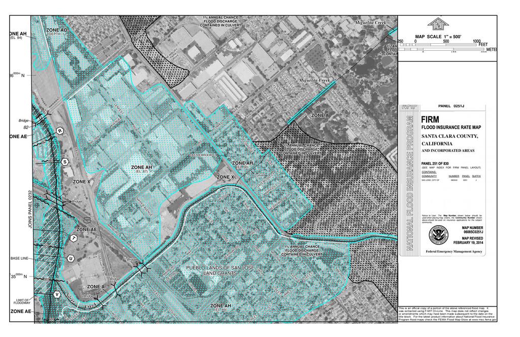
59
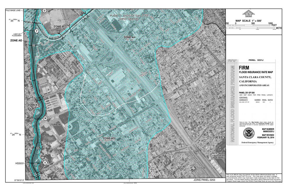
60

61
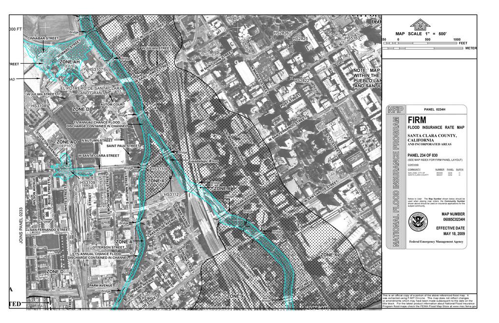
62
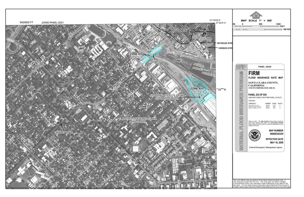
63
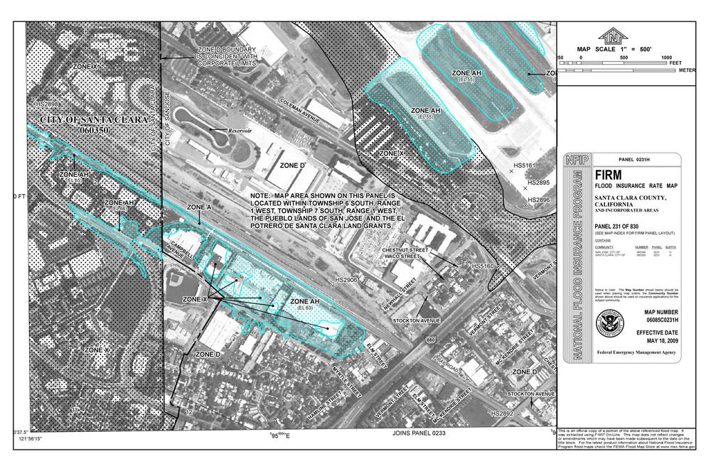
64
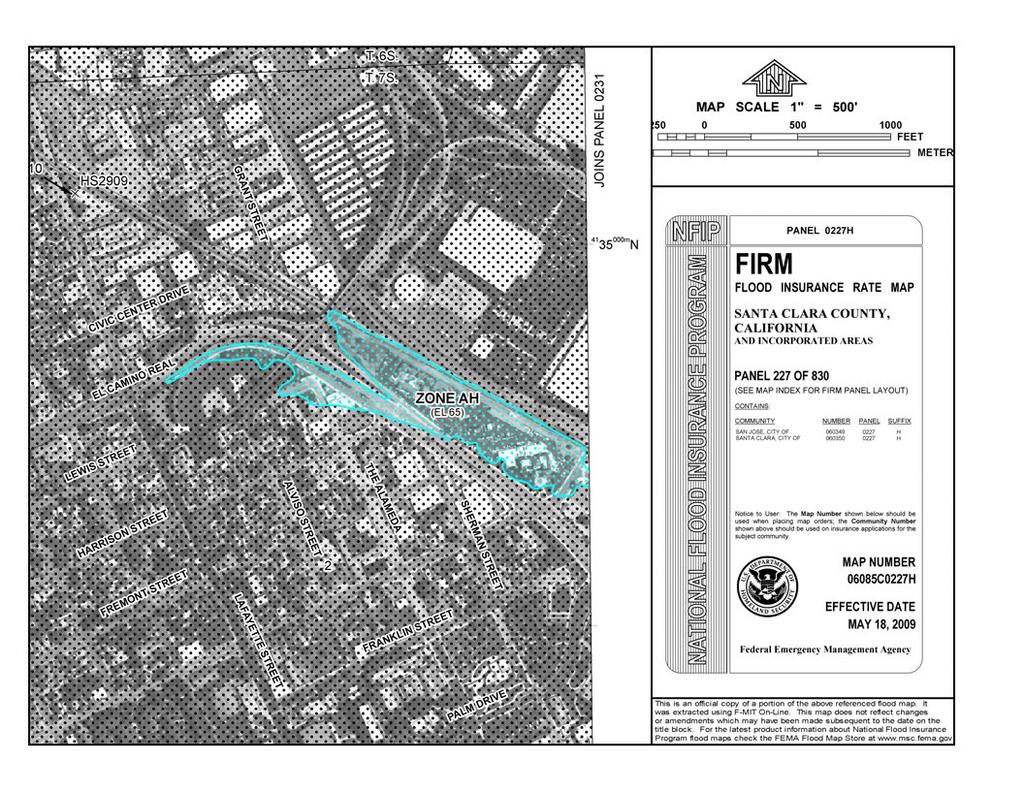
65