APPENDIX J NRCS-CPA 106 Forms and Correspondence
|
|
|
- Joleen Dalton
- 5 years ago
- Views:
Transcription

1 APPENDIX J NRCS-CPA 106 Forms and Correspondence Prepared For: Illinois Department of Transportation Indiana Department of Transportation Prepared By: Parsons Brinckerhoff July 2014
2 THIS PAGE INTENTIONALLY LEFT BLANK
3 Appendix J Table of Contents NRCS-CPA 106 Forms and Correspondence June 16, 2014 IDOT to Illinois Department of Agriculture... J-1 Attachments (shape files)... J-2 Will County IL-NRCS-CPA-106 Form... J-3 Lake County IN-NRCS-CPA-106 Form... J-4 Illiana Corridor J-i Tier Two Final Environmental Impact Statement
4 From: Kukielka, Katie L. Sent: Monday, June 16, :53 AM To: Subject: Illiana Corridor - Preferred Alternative Shapefiles Tim, As discussed during our phone call on Friday, June 6 th, I have attached a zip folder which contains updated shape files for the Illiana Corridor Preferred Alternative for your use in filling out the NRCS-CPA- 106 Form. A spreadsheet listing the shape files is also attached. Please note that the updated Preferred Alternative avoids the Agricultural Conservation Area in Peotone Township, Illinois. If you have any issues downloading these files and loading them into ArcGIS, please let me know and I can mail you a CD with the files. In addition, I have attached an updated version of the NRCS-CPA-106 Form with Parts I-III updated with information based on this Preferred Alternative. Please let me know if you have any questions. You may contact me at this address or call me at (630) Thanks, Katie Kukielka, P.E. Illiana Corridor Study Management Consultant Illinois Department of Transportation Bureau of Programming 201 Center Court Schaumburg, IL D: C: katie.kukielka@illinois.gov J-001
5 Illiana Corridor Illinois NRCS Data Transfer June 12, 2014 Ag Conservation Area Bridges Historic District IDNR State Fish and Wildlife Areas IL Floodplains IL Impacted Wetlands IL Impacted Wetlands - Secondary IL Prairies IL Additional Waters Index INHS Stream Survey + Annotation INHS Waterbodies_Wetlands_ Kankakee River Landlocked MNTP Preferred Alt - Design Option 4 Footprint Preferred Alt - Design Option 4 Edge of Pavement Preferred Alt - Footprint Preferred Alt - Edge of Pavement Parcels - Will Ponds_INHS_Survey + Annotation Railroads - IDOT Relocations - Commercial Relocations - Farm Buildings Relocations - Farmsteads Relocations - Other Relocations - Residential Road Closures Roads IDOT + Annotation Stream Relocation Riley Stream Relocation Wilton Center Trails IL Uneconomic Wauponsee Trail Wildlife Crossings J-002

6
7
8
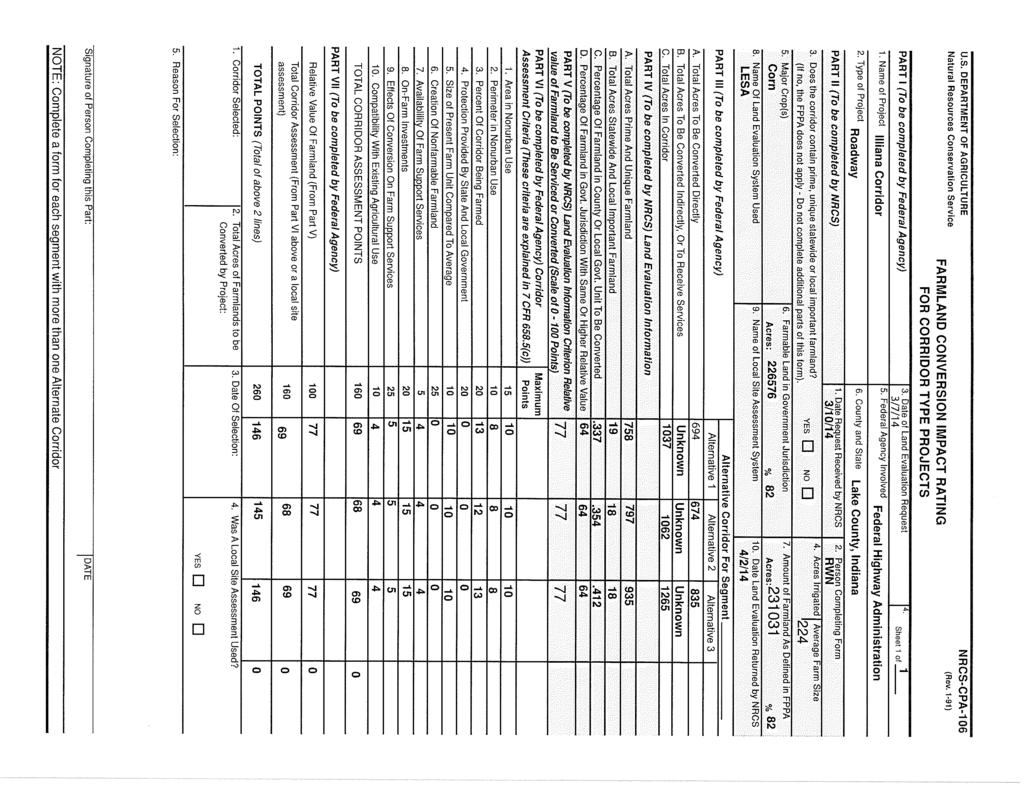
9 NRCS-CPA-106 (Reverse) CORRIDOR - TYPE SITE ASSESSMENT CRITERIA The following criteria are to be used for projects that have a linear or corridor - type site configuration connecting two distant points, and crossing several different tracts of land. These include utility lines, highways, railroads, stream improvements, and flood control systems. Federal agencies are to assess the suitability of each corridor - type site or design alternative for protection as farmland along with the land evaluation information. (1) How much land is in nonurban use within a radius of 1.0 mile from where the project is intended? More than 90 percent - 15 points 90 to 20 percent - 14 to 1 point(s) Less than 20 percent - 0 points (2) How much of the perimeter of the site borders on land in nonurban use? More than 90 percent - 10 points 90 to 20 percent - 9 to 1 point(s) Less than 20 percent - 0 points (3) How much of the site has been farmed (managed for a scheduled harvest or timber activity) more than five of the last 10 years? More than 90 percent - 20 points 90 to 20 percent - 19 to 1 point(s) Less than 20 percent - 0 points (4) Is the site subject to state or unit of local government policies or programs to protect farmland or covered by private programs to protect farmland? Site is protected - 20 points Site is not protected - 0 points (5) Is the farm unit(s) containing the site (before the project) as large as the average - size farming unit in the County? (Average farm sizes in each county are available from the NRCS field offices in each state. Data are from the latest available Census of Agriculture, Acreage or Farm Units in Operation with $1,000 or more in sales.) As large or larger - 10 points Below average - deduct 1 point for each 5 percent below the average, down to 0 points if 50 percent or more below average - 9 to 0 points (6) If the site is chosen for the project, how much of the remaining land on the farm will become non-farmable because of interference with land patterns? Acreage equal to more than 25 percent of acres directly converted by the project - 25 points Acreage equal to between 25 and 5 percent of the acres directly converted by the project - 1 to 24 point(s) Acreage equal to less than 5 percent of the acres directly converted by the project - 0 points (7) Does the site have available adequate supply of farm support services and markets, i.e., farm suppliers, equipment dealers, processing and storage facilities and farmer's markets? All required services are available - 5 points Some required services are available - 4 to 1 point(s) No required services are available - 0 points (8) Does the site have substantial and well-maintained on-farm investments such as barns, other storage building, fruit trees and vines, field terraces, drainage, irrigation, waterways, or other soil and water conservation measures? High amount of on-farm investment - 20 points Moderate amount of on-farm investment - 19 to 1 point(s) No on-farm investment - 0 points (9) Would the project at this site, by converting farmland to nonagricultural use, reduce the demand for farm support services so as to jeopardize the continued existence of these support services and thus, the viability of the farms remaining in the area? Substantial reduction in demand for support services if the site is converted - 25 points Some reduction in demand for support services if the site is converted - 1 to 24 point(s) No significant reduction in demand for support services if the site is converted - 0 points (10) Is the kind and intensity of the proposed use of the site sufficiently incompatible with agriculture that it is likely to contribute to the eventual conversion of surrounding farmland to nonagricultural use? Proposed project is incompatible to existing agricultural use of surrounding farmland - 10 points Proposed project is tolerable to existing agricultural use of surrounding farmland - 9 to 1 point(s) Proposed project is fully compatible with existing agricultural use of surrounding farmland - 0 points J-005