Florida Department of Environmental Protection
|
|
|
- Abigayle Hood
- 5 years ago
- Views:
Transcription

1 Florida Department of Environmental Protection Noticed General Permit for Dredging of Public Navigation Channel and Canal Infrastructure by the West Coast Inland Navigation District within Lee County
2 Background West Coast Inland Navigation District is charged with providing safe and adequate navigational access to public facilities. Department of Environmental Protection regulates activities in, on, or over waters of the state, and activities that affect sovereign submerged lands, to ensure water quality protection, habitat protection, and the equitable and reasonable use of state lands.
3 Past Partnering West Coast Inland Navigation District (WCIND) worked with the DEP Sarasota & Manatee Counties (2002) This noticed general permit did not include any dredging in Aquatic Preserves and Outstanding Florida Waters which are given added protection under both the regulatory and proprietary rules, and require the project to be clearly in the public interest.
4 Published Studies A Regional Waterway Systems Management Strategy for Southwest Florida, Antonini, Gustavo A., and Paul Box, 1996 Regional Waterway Management System, Phases 1-3, 1 Swett, Robert A., David A. Fann, Gustavo A. Antonini and Lana Carlin Alexander Dredging Public Channels: Analyzing the Benefits to Restricted Boats in Lee County Waterways, Waterways, Antonini, Gustavo A., Robert A. Swett, and David Fann, Under development
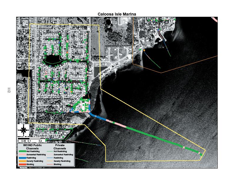
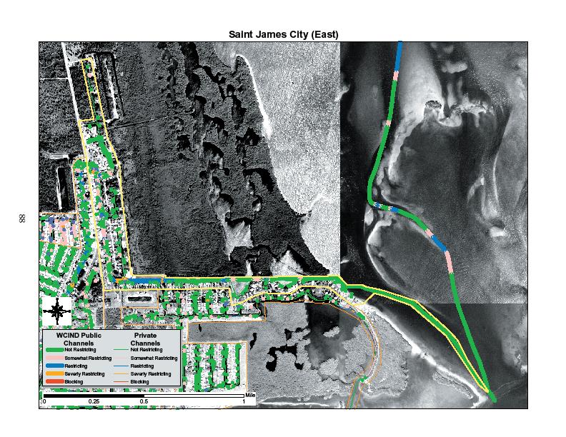
5 Results Characteristics of boats using various navigational channels Available depths of channels Number and drafts of boats that were: unrestricted somewhat restricted restricted or severely restricted
6 Terms Unrestricted Somewhat restricted Restricted Severely restricted Blocked Vessel drafts deeper than channel segment by*: No conflict 0.0 or 0.5 ft. 1.0 or 1.5 ft. 2.0 or 2.5 ft. > 3.0 ft. * Based on depths at mean lower low tide (MLLW)
7
8 Trafficsheds and Secondary Channel Segments Identification of commonly used navigational routes that serve public access facilities: Marinas Restaurants Public boat ramps Trafficshed channels An area containing a concentration of vessels that use a common channel, exclusive to a trafficshed, to gain access to secondary channels or the ICW: Marinas Residential canal systems Secondary channels A channel that provides access from more than one trafficshed to the ICW
9 ICW Trafficshed #1 Trafficshed #2 Marina Secondary Channel
10
11 Resulted in: Lee County 35 trafficsheds 12 secondary channel segments
12 Proposed Rule Concepts Draft rule under development
13 Goals Compared drafts of boats within the trafficshed to the available depths Provide safe, unrestricted navigation for majority of boaters, while minimizing amount of dredging necessary Target dredge depths accommodate an average of ~95% of vessels within each trafficshed or secondary channel segment
14 Goals Minimize impacts to water quality and submerged resources of Caloosahatchee River & SW FL Aquatic Preserves: GasparillaSound/Charlotte Harbor Matlacha Pass Pine Island Sound Estero Bay Streamline permitting & SSL authorizations
15 Issue Many commonly used channels had no history of dredging or permitting documentation The proposed dredging would occur in areas within aquatic preserves. Aquatic Preserves are given the highest protection under the rules and new dredging is strongly discouraged.
16 Rule requirements Any impact to water quality, submerged resources, or habitat must be minimized and mitigated Any dredging in the Aquatic Preserve must be demonstrated as clearly in the public interest under Chapters 373, 403, 253 and 258, Florida Statutes
17 Spot Dredging To address rule criteria, dredging within the Aquatic Preserves through the proposed Noticed General Permit would be limited to surgical spot dredging to demonstrate the minimal necessary impacts and provide navigational access consistent with historical conditions.
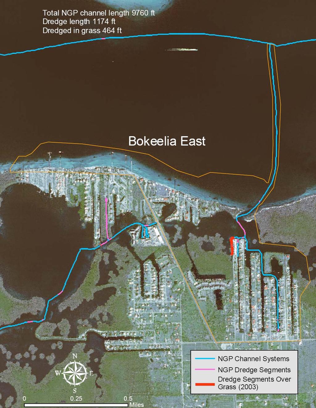
18 Proposed Noticed General Permit 30 day notice required $100 fee Not circulated for comments Separate SSL application & authorization required for activities on SSL; can be included in NGP Includes SPGP for most projects; separate Corps authorization required if not covered by SPGP
19 ERP Noticed General Permits DEP & WMDs Boat Ramps Piers and Associated Structures Rip Rap Fences Culverted Driveway or Roadway Crossings & Bridges of Artificial Waters Bridge Alteration, Replacement, Maintenance & Operation (Govts( Govts.. only) Minor Activities in Existing Rights-of of-way (Govts( Govts.. only) Underground Cable, Conduit or Pipelines Subaqueous Utility Crossings of Artificial Waters Culverts & Water Control Structures in Mosquito Control Impoundments ments Breaching Mosquito Control Impoundments by Mosquito Control Agencies Minor Activities Minor Activities by WMDs Environmental Restoration & Enhancement (DEP & WMDs only) Operating Schedules for Water Control Structures (DEP & WMDs only) Minor Works within National Forests
20 Proposed NGP Limits Will apply ONLY to public navigation channels & canals: Trafficsheds Secondary channel system Will not apply to channels that do not provide public access Will not apply to channels that have submerged resources including coral communities, sponge beds, or oyster beds
21 Limits, cont. To extent practicable, dredging alignments must: Follow existing channels & previously dredged areas Avoid & minimize impacts to seagrass communities
22 Limits, cont. < 8,500 cubic yards of dredged material cumulatively removed over 5-year 5 period within each trafficshed or secondary channel system No Class II approved shellfish harvesting waters eas_shamap.htm
23 Requirements Does not apply to areas already subject to a currently valid individual Environmental Resource Permit Dredging limited to a top channel width of 30 ft. and a bottom width of 20 ft. Dredging is limited to target depths per trafficshed/secondary channel
24 Target Depth Represents the minimum necessary depth to provide access to majority of boats And represents minimal dredging and resource impact in the aquatic preserves Developed through discussion between Lee County, WCIND, Sea Grant, DEP regulatory staff, and DEP Coastal and Aquatic Management staff
25 Trafficshed or Secondary Channel System Name NGP Dredge Depth (ft) All Channels Length (ft) Public Channel Length (ft) Total NGP Dredge Length (ft) Public Channel Length in AP (ft) Dredge Length in AP (ft) Dredge Length Outside AP (ft) Dredge Length in AP Sea Grass (ft) Dredge Length in Any Sea Grass (ft) Bob Swett 10/26/2006 Bokeelia (east) AP = Aquatic 464Preserve Bokeelia (west) Burnt Store Marina Caloosa Isle Marina Cape Coral Southwest Chantry Canal Compass Rose Deep Lagoon Demere Key East Fort Myers Everest Canal Fish Tale Marina Fish Trap Bay Fort Myers Yacht Basin Franklin Locks East Getaway Hancock Creek Imperial River-Lower Imperial River-Upper
26
27 Notice Requirements Notice to use NGP required for each dredging event, including details: Schedule of work Location, length, width, depth Volumes to be dredged Capacity & location of disposal sites Water quality monitoring plan Resource inventory report (qualitative) Plan for resource relocations Pre-application meeting required
28 Conditions Resource relocations: All seagrass Individual specimens corals, sponges & oysters to maximum extent practical Upland disposal of dredged material Prevent water quality violations (mixing zone granted & use of turbidity controls around work sites) Manatee & marine turtle protections
29 Conditions, cont. As-built survey after completion Channels marked with aids to navigation Channels < 4 ft. MLLW marked with precautionary signage WCIND to facilitate update of Lee County Boater s s Guide
30 Resource Impacts Impacts to seagrasses offset through establishment of No Internal Combustion Motor Zones ( NICMZs,( NICMZs, aka Pole and Troll Zones) Allows natural healing of prop scar impacts Avoids future impacts Provides public interest in aquatic preserves
31 Pole and Troll Zones Zones marked Allows use of electric trolling motors or poling for fishing or other passive recreational uses Enforceable by Lee County sheriff or other law enforcement agencies Must be established through rule making by DEP or FWCC
32 Pole and Troll Zones Lee County and DEP developed list of potential Pole and Troll zones that would be feasible, based on considerations of: Location Size & shape Characteristics (heavy focus on prop scarred areas) Potential benefit Enforceability
33 Pole and Troll Zones Estimated dredging impacts to seagrass based on maps developed by Florida Fish and Wildlife Conservation Commission Impacts within each Aquatic Preserve must be offset by a Pole and Troll zone located within that AP Impacts to seagrasses outside Aquatic Preserves may be offset within an AP

34 Estero Bay NICMZs

35 Matlacha Pass NICMZs

36 Pine Island NICMZs
37 Possible NICMZ Areas and Locations Impact Area Gasparilla Sound/ Charlotte Harbor NICMZ Name Bokeelia West North half (PI1) Pine Island Sound Bokeelia West South half (PI1) Matlacha Pass Matlacha Pass NW South (MP2) Estero Bay Big Carlos Pass (EB2) Acres (approx.) Chili Pepper (EB6) 303
38 Pole and Troll Zones Monitoring will be conducted after the establishment of the Zone to document benefits to seagrasses Must be a expected benefit adequate to offset the impacts to submerged resources and demonstrate that the project is clearly in the public interest (in addition to the public interest aspects of providing safe navigation)
39 Submerged Lands NGP would also constitute Consent of Use under Chapter 253 and 258 Florida Statutes to conduct works on sovereign submerged lands
40 Status Still in Rule making process DEP has responded to letters from several conservation groups listing concerns We are planning to hold additional meetings with these groups #erp