SUPPLEMENTAL DRAFT ENVIRONMENTAL IMPACT STATEMENT NORTH BELT FREEWAY SUMMARY INTRODUCTION
|
|
|
- Elijah Watts
- 5 years ago
- Views:
Transcription
1 SUMMARY INTRODUCTION The Arkansas State Highway and Transportation Department (AHTD), in cooperation with the Federal Highway Administration (FHWA), is proposing a highway project located in northern Pulaski County, Arkansas. This project, commonly known as the North Belt Freeway, will consist of a four-lane, divided highway constructed to Interstate standards and located between Highway 67 and the Interstate 40/430 Interchange. The completion of the eastern segment of the North Belt Freeway between Highway 67 and the Interstate 40/440 Interchange left this proposed freeway project as the only remaining segment of the urban area s circumferential freeway to be implemented. The project is between 12 and 15 miles (19 and 24 kilometers) in length and will be constructed on new location with an average estimated right of way width of 300 feet (91 meters). Access will be fully controlled with interchanges and grade separations utilized at selected locations. The funding source for the right of way acquisition and construction of this project has not been determined. The North Belt Freeway project was not placed on the current Central Arkansas Regional Transportation Study (CARTS) Transportation Improvement Plan (TIP) or the Statewide Transportation Improvement Plan (STIP) due to the history of uncertainty related to a Selected Alternative. After receipt of a Record of Decision (ROD), an appropriate development phase will be amended into the TIP/STIP. Tolling is a financing option that could be considered, if additional funding is needed. If it was determined that this project would be a toll facility, additional environmental analysis would be conducted to assess any impacts associated with the conversion of this proposed freeway into a toll facility. The proposed North Belt Freeway is included in the CARTS Metro 2030 Metropolitan Transportation Plan and has been part of the transportation planning efforts in northern Pulaski County since Since 1979, the Pulaski Area Transportation Study, now expanded to the CARTS, has shown the proposed North Belt Freeway essentially in the same general corridor as the Selected Alternative identified in the project s 1994 Final Environmental Impact Statement (FEIS) and ROD. SUMMARY S-1
2 In 1997, the local metropolitan planning organization, Metroplan, did not include the North Belt Freeway project in the CARTS Transportation Improvement Program. This decision was made because a portion of the Selected Alternative was not compatible with the City of Sherwood's Master Street Plan. Since the AHTD was unable to proceed with activities on the North Belt Freeway within a 3-year period after the ROD, reassessment of the Selected Alternative became necessary. In 2003, a Preliminary Evaluation was conducted by the AHTD in order to resolve issues necessary to proceed with a FEIS reassessment. Public comment from the expanding residential neighborhoods adjacent to the Selected Alignment and Sherwood s continuing opposition resulted in the necessity to produce this Supplemental Draft Environmental Impact Statement (SDEIS) as the means of conducting a project reassessment. The development of alternatives and detailed environmental study of those alternatives is part of the SDEIS process that will result in the designation of a Preferred Alternative. Preparation of a new FEIS and new ROD that fully evaluates the Preferred Alternative and documents the Selected Alternative will complete the environmental process. This process ensures that alternatives meeting the purpose and need of the project are fully evaluated and are developed to minimize the potential environmental impacts. PURPOSE AND NEED The following project needs were identified in the project s 1994 FEIS: 1) Provide a direct east/west facility connecting the developing northeast and northwest parts of Pulaski County; 2) Increase safety and decrease congestion on existing streets and highways, especially on Highway 67 and Highway 107; 3) Provide traffic service for local traffic demands; and 4) Provide a highway facility consistent with the Pulaski Area Transportation Study and related Land Use Plans by providing a facility which: SUMMARY S-2
3 a) Serves as a bypass for east-west through traffic in northern Pulaski County. b) Provides improved access for the traffic generated by the population growth in northern Pulaski County. c) Completes the northern link in the Little Rock/North Little Rock metro area s circumferential freeway by providing a more direct connection of Highway 67 with the interchange of Interstate 40 with Interstate 430. Review of land development and traffic growth in the region since the completion of the 1994 FEIS does not indicate a change in the purpose or need for the proposed North Belt Freeway. Some specific findings include: 1) Population growth has continued and even accelerated throughout the project area. Areas at both ends of the project area that provide destinations for the facility s motorists have also continued to grow. 2) Traffic growth has continued to reflect the development trends in the region. 3) The existing and planned roadway network is not sufficient to provide the desired quality of traffic operations within the Little Rock/North Little Rock urban area. 4) The specific proposed project alignment alternatives are being threatened by development. 5) Camp Robinson, an Arkansas National Guard training center, continues to create a 10-mile (16-kilometer) long barrier to civilian travel that will continue to focus east-west travel in northern Pulaski County onto Interstate 40 if an alternate route is not developed. 6) Camp Robinson training and security mission can be enhanced with the implementation of this facility. ALTERNATIVES DEVELOPMENT Development of alternatives for this SDEIS was conducted in a manner that considered the history of the project while also taking into account the amount of time that has passed since SUMMARY S-3
4 the original ROD in Input from Agency Scoping, Public Officials meetings, and Public Involvement meetings also played a role in the development of the alternatives that are being evaluated in the SDEIS. The Notice of Intent for preparation of this SDEIS, published in April 2004, stated that the entire length of the project would be reassessed due to the amount of time that had passed since the ROD. The reassessment of the project area began with a meeting with Army National Guard officials in March 2004 regarding Camp Robinson's development plans. From this meeting and subsequent meetings, the officials updated their preferred alignment for the North Belt Freeway through Camp Robinson related to land use changes that have occurred since the original alignment was set in the early 1990s. A corridor was developed for the alignment through Camp Robinson and added to a project area east of Camp Robinson to create the project area for the SDEIS. An Agency and Public Officials Scoping meeting was held in March 2005 to obtain information about current issues and constraints in the proposed project study area. Alignment alternatives were developed in the project area based upon alignments from previous environmental documents, existing highways, facilities, landforms, and other known constraints. The option for construction of either a grade separation or an interchange was included for the alignment alternatives that crossed Oneida Street in response to public and community comments. The alignment alternatives were presented for public comment in November Revisions to the alignment alternatives presented at the public involvement meetings were made after analyses of public comments and preliminary constraints (Figure S-1). A public officials meeting was held in January 2006 to discuss the revised alignment alternatives. The No-Action Alternative was retained throughout the study as a basis for comparing the relative benefits and impacts of the alignment alternatives. The No-Action Alternative consists of no improvements to the present system and no expenditures other than regular maintenance of the existing route. SUMMARY S-4
5 Runyan Acres Winifree Creek Kellogg Creek Camp Kellogg Creek Jacksonville-Cato Rd Ison Ln Bobbit Lane Hatcher Rd Gravel Ridge Bayou Meto 107 C General Samuels Jacksonville 365 Newton Creek Robinson Miles Creek C Kellogg Acres Rd Loop Rd Mine Rd a Miller Rd Oakdale Rd B Fears Lake Jacksonville Cutoff b W. MainSt Oneida St Robinson Army Airfield Spring Creek Woodruff Creek Batesville Pike Wayside Dr 107 A Sherwood Brockington Rd Oak Grove Maryland Ave Indianhead Lake Trapp Rd Engineers Lake Kelly Rd MacArthur Dr North Little Rock Municipal Airport Peeler Lake North Little Rock Crystal Hill Legend* Ink Bayou Job R60101 AHTD - Environmental GIS - Farrell 5/10/2006 Miles Kilometers Common Alignment Alignment Alternative A Alignment Alternative B Alignment Alternative C Segment a Segment b Interchange Grade Separation Interchange or Grade Separation (...to be determined) Relocated Batesville Pike Camp Robinson *Colored Lines Represent a 300 ft. Wide Corridor Figure S-1 Alignment Alternatives North Belt Freeway
6 This page is intentionally blank. SUMMARY S-6
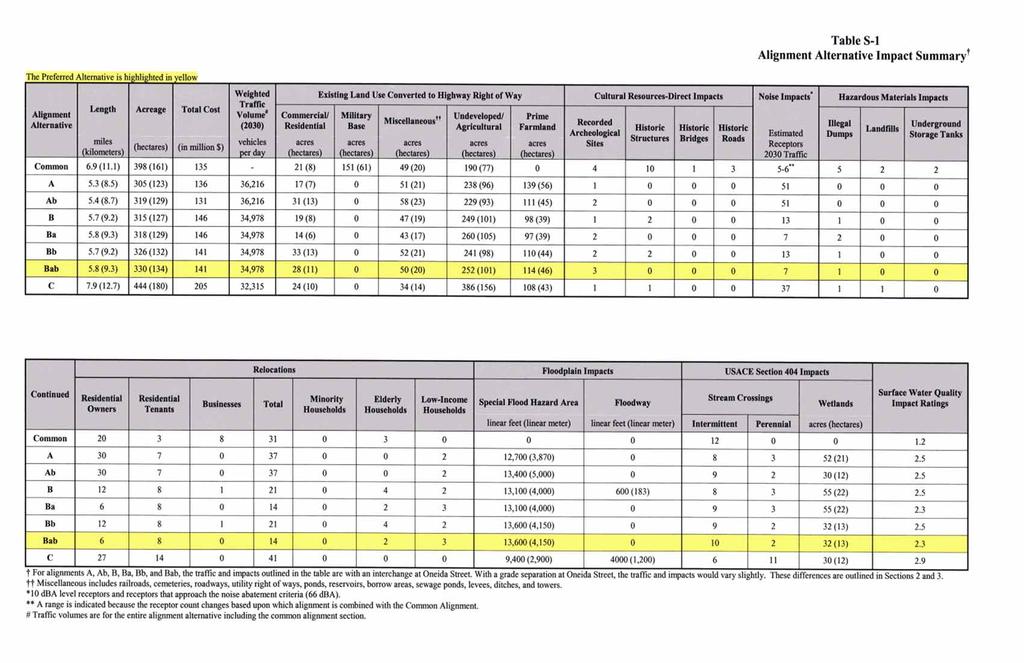
7 SUMMARY OF BENEFICIAL AND ADVERSE IMPACTS Construction of the proposed project would provide the following benefits: 1) Provide a highway directly connecting the rapidly growing northeast and northwest parts of Pulaski County; 2) Mitigate the impact of Camp Robinson on travel in the region; 3) Increase safety by decreasing congestion on existing streets and highways, especially on Highway 67 and Highway 107; 4) Provide traffic service for local traffic demands, and 5) Provide a highway facility consistent with the Central Arkansas Regional Transportation Study and related plans by providing a facility which: a) Serves as a bypass for through traffic in northern Pulaski County. b) Provides improved access to northern Pulaski County. c) Completes the northern link in the Little Rock/North Little Rock urban area s circumferential highway network. A summary of other impacts is also included in Table S-1. THE PREFERRED ALTERNATIVE After a full evaluation of the information contained within this document, and as a result of participation by resource agencies, the local officials, the public, and the response gained through these avenues, sufficient information was available to identify a Preferred Alternative for the proposed facility. The Interdisciplinary Staff, composed of representatives from various disciplines of AHTD and FHWA, reviewed the SDEIS. This staff met and considered the potential impacts, advantages, and disadvantages of the various alignment alternatives before coming to a SUMMARY S-7
8 recommendation. The Impact Summary in Table S-1 was utilized, as well as Table S-2, the Alignment Alternatives Comparison Table, which illustrates the major advantages and disadvantages for each alignment alternative. The various alignment alternatives were compared and Alignment Alternative Bab was recommended for combination with the Common Alignment and designation as the Preferred Alternative. The Preferred Alternative is shown in Figure S-2. This Alternative: 1) Meets the project purpose and need; 2) Minimizes overall impacts; 3) Best balances the benefits expected from the project with the overall impacts; and 4) Provides good access to communities and other regional highway facilities. The Preferred Alternative is 12.7 miles (20.4 km) in length, with five interchanges and eight grade separations proposed. An interchange is not proposed at Oneida Street in order to minimize residential relocations, wetland impacts, and impacts to the surrounding subdivisions. Additionally, interchange constructability issues exist due to the proximity of Kellogg Creek and Fears Lake, and spacing with the Highway 67 Interchange would not be optimal for traffic operations. The Preferred Alternative avoids recreation areas and the Kellogg Mine area, while minimizing relocations, wetland, and noise impacts to the maximum extent possible. The Preferred Alternative will undergo public, local official, and state and federal resource agency review during the public hearing(s) and comment period on the SDEIS. The comments will be assessed and, if necessary, the Preferred Alternative may be modified either through the choice of a different alignment alternative or through shifts or changes to the Preferred Alternative. After a complete evaluation of the comments received, an alternative will be chosen for documentation in the FEIS. The FEIS documentation will contain responses to the comments received on the SDEIS, and address comments and changes related to the Preferred Alternative. SUMMARY S-8
9
10 This page is intentionally blank. SUMMARY S-10
11 Table S-2 Alignment Alternative Comparison The Preferred Alternative is highlighted in yellow Alignment Alternative Common A Ab B Ba Bb Bab C Advantages Approved route through Camp Robinson Shortest alignment alternative Lower cost estimates Highest traffic volume Lowest cost estimates Lowest wetland impacts Highest traffic volume Lower number of relocatees Lower number of noise receptors Lower prime farmland impacts Lowest number of relocatees Lowest number of noise receptors Lowest impact on commercial/ residential land Lowest prime farmland impacts Lower number of relocatees Lowest number of relocatees Lowest number of noise receptors Lower wetland impacts Lowest wetland impacts Disadvantages Bisects Crystal Hill neighborhood High number of relocatees High number of noise receptors Impacts several subdivisions Higher wetland impacts Highest prime farmland impacts High number of relocatees High number of noise receptors Impacts several subdivisions Highest wetland impacts Impacts one subdivision Highest wetland impacts Separates Kellogg Acres neighborhood from Oakdale subdivision Highest impact on commercial/ residential land Impacts two subdivisions Separates Kellogg Acres neighborhood from Oakdale subdivision Longest and most expensive alignment alternative Most relocatees Impacts one subdivision High floodplain and stream crossing impacts resulting in greatest potential for water quality impacts Lowest traffic volume SUMMARY S-11
12 This page is intentionally blank. SUMMARY S-12
13 Winifree Creek Kellogg Creek Runyan Acres Kellogg Creek Jacksonville-Cato Rd Bobbit Lane Hatcher Rd Bayou Meto 107 General Samuels Jacksonville Camp Ison Ln 365 Newton Creek Robinson Miles Creek Kellogg Acres Rd Loop Rd Mine Rd Miller Rd Oakdale Rd Fears Gravel Ridge Lake Jacksonville Cutoff W. MainSt Oneida St Batesville Pike Wayside Dr Robinson Army Airfield Spring Creek Woodruff Creek 107 Sherwood Brockington Rd Oak Grove Maryland Ave Indianhead Lake Trapp Rd Engineers Lake Kelly Rd MacArthur Dr North Little Rock Municipal Airport Peeler Lake Crystal Hill North Little Rock Legend Ink Bayou Job R60101 AHTD - Environmental GIS - Farrell 12/15/2006 Miles Kilometers Preferred Alternative Interchange Grade Separation Relocated Batesville Pike Camp Robinson Figure S-2 Preferred Alternative North Belt Freeway
14 This page is intentionally blank. SUMMARY S-14