ENERGY PRODUCTION & CONSUMPTION. Environmental damage due to flooding and. financial loss due to decreased generating
|
|
|
- Domenic Lewis
- 5 years ago
- Views:
Transcription


1 US HYDROPOWER PRODUCTION In the United States hydropower supplies 12% of the nation s electricity. Hydropower produces more than 90,000 megawatts of electricity, which is enough to meet the needs of 28.3 million consumers. Hydropower accounts for over 90% of all electricity that comes from renewable resources (such as solar, geothermal, wind and biomass). millibars kilotons of oil A primary goal of reservoir operators at hydropower facilities is optimizing flood protection vs. energy generation. If reservoir operators underestimate flood volume, the reservoir system will be unable to fully regulate flow. As a result, water NORWAY must be spilled over into spillways. Annual Heating Oil Consumption Environmental damage due to flooding and 3500 financial loss due to decreased generating 3000 capacity result. The link between a positive 2500 and increased East Coast precipitation The Index 5 suggests that reservoir operators in this region could gain from knowing more about the. 0-5 Average Winter Temperature 0 C ENERGY CONSUMPTION AND PRODUCTION IN NORWAY AND THE The demand for heating oil in Norway clearly Average Winter Precipitation 110 shows human sensitivity to changes in the. 90 Cooler winters and a generally negative 70 prevailed during the late 1970 s resulting in a greater demand for heating oil. Things changed in the early 1980 s as the index switched to a positive phase and Norway became warmer, resulting in decreased demand for heating oil. These changes in demand vary by 10-15% of the average demand between mm of rainfall Human Impacts ENERGY PRODUCTION & CONSUMPTION Norway is the world s sixth largest hydropower producer, and the largest producer of hydropower in Europe. Annual winter precipitation in Norway can be thought of as a surrogate for streamflow and hence hydropower generation. Between 1980 and 1993, a period of increasingly positive years, precipitation was higher than normal, resulting in increased water inflow for power generation.

2 THE NORTH ATLANTIC OSCILLATION The is a large-scale see-saw in atmospheric mass between the subtropical high located near the Azores and the sub-polar low near Iceland. An index can be derived that tracks the behavior of the through time. The index shows both high frequency and low frequency variability. In the later portion of the record there is a positive trend, steadily increasing with time. The high and low frequency variability of the is believed to be related to natural variations in the The index is defined as the anomalous pressure difference between the Icelandic Low and the Azores High. The figure at right shows the measured sea level pressure difference between Stykkishomur, Iceland and Lisbon, Portugal over the period during the winter season (December through March) NATURAL VARIABILITY & the Atlantic Ocean The is the dominant mode of winter climate variability in the North Atlantic region. The corresponding index varies from year to year, but also exhibits a tendency to remain in a positive or negative phase for intervals lasting several years (see red and blue sections of the index above). The characteristic time scale of atmospheric circulation anomalies are only on the order of weeks. However, the ocean, with its large capacity to absorb heat, has significant long-term memory, and may set the pace for decadal variations in the. Ocean currents have the ability to propagate temperature anomalies across the Atlantic, which may influence the dynamics of the overlying atmosphere. As a result, some scientists believe that decadal variations in the are due to two-way communication between the ocean and atmosphere. Other scientists have suggested that the oceanic variability is merely the integrated response of the ocean to high frequency variability in the atmosphere. Another hypothesis is that the might be influenced by variability in the tropical Atlantic Ocean. Once the interactions between the ocean, atmosphere, and land are more clearly understood, it may be possible to forecast year-to-year changes in the.


3 climate system, while the trend witnessed over the last 30 years may be caused by anthropogenic impacts such as ozone depletion and increased CO 2 emissions. One of the fundamental questions driving -related research is: How do these two influences, natural climate variability and global warming, interact? Index POSITIVE NEGATIVE ANTHROPOGENIC CHANGE & Global Warming Over the past thirty years, the has steadily strengthened, rising from its low index state in the 1960s to a historic maximum in the early 1990s. This trend accounts for a significant portion of Northern Hemisphere wintertime temperature increase over Eurasia, a major component of the recent warming. Consequently, the has made its way into the global warming debate. More recently, scientists became aware of a connection between variations in temperature at the earth s surface and the strength of the stratospheric winter vortex, located about 60 km above the earth s surface. Changes in stratospheric circulation can be forced by several different mechanisms including ozone depletion, volcanic dust, and CO. Rising CO 2 concentrations cool and strengthen the stratospheric winter vortex which translates into stronger surface winds. Enhanced surface westerly winds are consistent with a positive index. These changes, which modulate the temperature over northern Eurasia and America, are sometimes referred to as the Arctic Oscillation.


4 Freshwater constitutes only ~2.5% of the total volume of water on earth, and two-thirds of it is trapped in glacial ice. Only 0.77% of freshwater is held in places more accessible to humans such as aquifers, lakes, rivers, and the atmosphere. River runoff is the most accessible source and accounts for much of the water used for irrigation agriculture, industry, and hydropower generation. New dam construction has the potential to increase accessible runoff by ~10% over the next 30 years, however population is projected to increase by more than 45% during that period. As a result humans will become increasingly sensitive to natural variations in precipitation and river runoff. Euphrates River Runoff [m3/sec] : mean: : Perhaps the most sensitive of all regions is the Middle East, where usable freshwater is already scarce. With population increasing by 3.2% each year and irrigation practices consuming upwards of 80% of available water supply, water is a key variable affecting regional public health and political stability. Much of the current focus in Middle Eastern water policy has been the environmental and socio-economic impacts associated with increased damming along the Tigris-Euphrates River system Turkey, because it has the good fortune of being situated at the headwaters of the Tigris-Euphrates River system, can literally turn off the supply of water to its downstream neighbors and has threatened to do so on occasion. For example, when the Ataturk Dam was completed in 1990, Turkey 0 stopped the flow of the Euphrates entirely for one J F M A M J J A S O N D month, leaving Iraq and Syria in considerable distress. However natural climate variability, which has no political alliances, can be attributed to variations in Turkish precipitation and Euphrates River runoff and is linked to changes in the. Even the recent trend in the index can be seen in historical precipitation data; with droughts occurring in Turkey during the 1980s and the early 1990s and wet conditions generally occurring during the 1960s and the late 1970s. Human Impacts HYDROLOGY & WATER RESOURCE MANAGMENT


5 IMPACTS ASSOCIATED WITH A NEGATIVE YEAR. TROPICAL ATLANTIC/ GULF COAST Warmer sea surface temperatures cause increases in number and strength of hurricanes ATLANTIC Increased growth and recruitment of Northern Cod EASTERN LONG ISLAND Decreased brown tide events increase scallop harvests As we now know, this east-west temperature see-saw was due to changes in the north-south contrast in sea level pressure over the North Atlantic Ocean, with low pressure in the north near Iceland and high pressure in the south near the Azores. The pressure contrast drives surface winds and wintertime storms from west to east across the North Atlantic. Variations in the pressure gradient affect the winds and storm tracks, thereby altering sea surface temperature, air temperature and precipitation. The impacts of this climate phenomenon reach as far eastward as central Siberia and the eastern Mediterranean, southward to West Africa, westward to North America and extend throughout the entire Arctic region. These changes in atmospheric pressure and its associated impacts are known as the North Atlantic Oscillation (). PORTUGAL & SPAIN Increased grape and olive harvests TURKEY Increased precipitation and streamflow in the Tigris-Euphrates River Basin


6 NOAA Office of Global Programs 1100 Wayne Avenue, Suite 1225 Silver Spring, MD PHONE NEGATIVE ER FEW ST MS R O DRY WET FOR MORE INFORMATION


7 WET MS R O ST MORE POSITIVE DRY


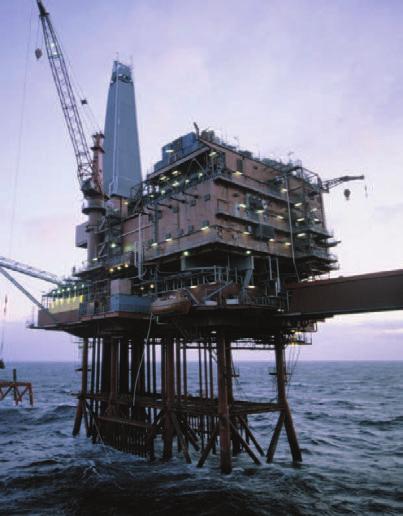
8 IMPACTS ASSOCIATED WITH A P0SITIVE YEAR. NORTHEASTERN US Increased temperature results in decreased number of snow days NORTH SEA Increased wave height affects safety of oil rigs and their operators In the late 16th century, the missionary Hans Egede Saabye, after several years of travelling back and forth between Scandinavia and Greenland, recorded in his journal: NORWAY Surplus water in hydroelectric reservoirs provides potential for selling surplus electricity SCANDINAVIA Length of the plant growth season is lengthened by 20 days CENTRAL US Increased precipitation and river runoff ºC ºF This figure shows surface temperature response and some well-documented socio-economic impacts associated with a strong index year. Temperature response is a measure of the degree to which winter sea surface/ land station temperatures vary as a result of changes in the index. RED highlights those regions which are warmer at times when the northsouth pressure gradient over the Atlantic Basin is greater than usual. Blue marks regions which are cooler. Sea surface temperatures are taken from a reconstruction of historical data while the colored points are landbased weather stations. In Greenland, all winters are severe, yet they are not alike. The Danes have noticed that when the winter in Denmark was severe, as we perceive it, the winter in Greenland in its manner was mild, and conversely.