Public Information Centre
|
|
|
- Beverley Morris
- 5 years ago
- Views:
Transcription
1 Vineland West Private Water System Municipal Class Environmental Assessment Public Information Centre Tuesday, July 12, 2016, 6 to 8 p.m. Vineland Research and Innovation Centre, Rittenhouse Hall
2 Welcome! Please sign in on the sheet provided We suggest viewing the display boards in numerical order Feel free to ask questions Comment sheets are provided please place completed sheets in the Comment Box or send them to one of our study representatives: Jennifer Whittard Consultant Project Manager Cole Engineering Group Ltd. 195 King Street, Suite 205 St. Catharines, ON L2R 3J6 P: E: Adam Allcock Manager of Water & Wastewater Services Town of Lincoln 4800 South Service Rd Beamsville, ON L0R 1B1 P: x.286 E:

3 Study Purpose The Town intends to upgrade and assume ownership of the Vineland West Private Water System (VWPWS) VWPWS services 13 homes and one greenhouse operation via ~ 1.5 km of existing 50-mm diameter watermains Watermains will be upsized to meet Municipal Design Standards The purpose of the Class EA is to select the preferred watermain route through an environmentally sound planning process open to public participation
4 Study Background Since the VWPWS receives water from the Town of Lincoln Jordan-Vineland Distribution System, the Ministry of Environment and Climate Change (MOECC) requires that the private owners comply with the Safe Drinking Water Act In March 2016, the owners of the VWPWS entered into an Agreement with the Town of Lincoln for drinking water quality monitoring services in order to comply with the Safe Drinking Water Act The Agreement, endorsed by Council, allows for Town of Lincoln Licensed Water Operators to conduct regular sampling and monitoring of the water quality within the VWPWS, as recommended by the MOECC Until the VWPWS is upgraded and assumed as municipal infrastructure, the private VWPWS owners are still responsible for any required maintenance/repairs to the existing system
5 Study Background Municipal easements are required for watermain routing through private property; no easements will be required outside of the VWPWS service area Easements will be registered on title and will provide the Town of Lincoln with the legal right to install, operate and maintain the watermains Proposed municipal water supply infrastructure is to replace the existing system and will not be extended outside of the VWPWS service area Project benefits include: Transfer of future responsibilities from private VWPWS owners to the Town of Lincoln, including responsibility for water quality, supply and operational maintenance Ensured compliance with the Safe Drinking Water Act Possible provision of fire hydrants


6 Overview of the Class EA Process The Ontario Environmental Assessment Act requires that most municipal projects follow an approved Class EA process This study is being conducted in accordance with the approved requirements for a Schedule B project as described in the Municipal Engineers Association s Municipal Class EA document Upon completion of the Class EA process, a Project File Report will be made available for review & comment Phase 1: Problem or Opportunity Identify the problem(s) or opportunities Notice of Study Commencement and PIC Phase 2: Alternative Solutions Identify alternative solutions Inventory natural, cultural and socio-economic environments Identify potential impacts of the alternative solutions after mitigation Evaluate the alternative solutions considering environmental and technical impacts Identify a recommended solution Confirm the preferred solution based on input from the PIC and review agencies Public Information Centre July 12, 2016 We are here Project File Report Prepare Project File Report to describe the activities undertaken through Phases 1 and 2 Notify stakeholders of study completion and of the Part II Order provision in the EA Act Place Project File Report on public record for review for 30calendar days Implementation Proceed to detailed design and construction Notice of Study Completion
7 Problem or Opportunity Statement To maintain compliance with the requirements of Ontario s Safe Drinking Water Act, the Town of Lincoln intends to upgrade the existing VWPWS and assume the new infrastructure as part of the Jordan-Vineland Distribution System. Prior to assuming the private system as a public asset, the existing watermains need to be upgraded to Municipal Design Standards and easements obtained from existing VWPWS Owners where the watermains cross private property. The upgraded water distribution system will service existing VWPWS Owners only, while minimizing impacts on natural, cultural and social features of the study area.

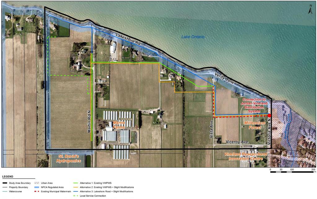
8 Study Area and Alternative Routes
9 Comparative Evaluation Evaluation Criteria Natural Environment Potential effects on designated natural areas, existing vegetation and wildlife and wildlife habitat Alternative 1: Existing VWPWS Alignment No designated natural areas (ANSIs, significant woodlands, wetlands or valleylands) and no significant wildlife or fish habitat Minimal vegetation removal required Some potential for significant wildlife habitat complete botanical and breeding bird surveys during detailed design Potential effects on water resources and hydrogeology Social/Cultural Environment Potential for loss and/or disruption to archaeological and/or cultural heritage resources Potential effects on residents and businesses No designated natural areas (ANSIs, significant woodlands, wetlands or valleylands) and no significant wildlife or fish habitat Minimal vegetation removal required Some potential for significant wildlife habitat complete botanical and breeding bird surveys during detailed design No significant surface water feature crossings Shallow groundwater table construction dewatering may be required Significant Groundwater Recharge Area no reduction of recharge rates due to no increase in impervious cover Highly Vulnerable Aquifer area use trench plugs to avoid creation of preferential groundwater flow pathways along construction trenches Cherry Birch and Gray Ratsnake (endangered) previously reported in area complete botanical survey during detailed design Potential to encounter other SAR in grassland/hayfield habitat and edge/early successional habitat tree removal to occur outside of migratory bird nesting season (May 1-July 31) High archaeological potential for most areas outside the paved roadway Stage 2 archaeological investigations (test pitting and pedestrian survey) required No designated built heritage resources or cultural heritage landscapes identified Temporary nuisance impacts during construction, i.e., increase in dust, noise and/or vibrations mitigate with standard best practices No impacts to private entrances Long-term benefits of municipal water servicing No significant surface water feature crossings Shallow groundwater table construction dewatering may be required Significant Groundwater Recharge Area no reduction of recharge rates due to no increase in impervious cover Highly Vulnerable Aquifer area use trench plugs to avoid creation of preferential groundwater flow pathways along construction trenches Cherry Birch and Gray Ratsnake (endangered) previously reported in area complete botanical survey during detailed design Potential to encounter other SAR in grassland/hayfield habitat and edge/early successional habitat tree removal to occur outside of migratory bird nesting season (May 1-July 31) High archaeological potential for most areas outside the paved roadway Stage 2 archaeological investigations (test pitting and pedestrian survey) required No designated built heritage resources or cultural heritage landscapes identified Temporary nuisance impacts during construction, i.e., increase in dust, noise and/or vibrations mitigate with standard best practices Temporary disruption to three private entrances as construction passes Long-term benefits of municipal water servicing Compliance with applicable planning policies and land uses May encounter cobbles/boulders, sand & gravel deposits and shallow bedrock which may pose construction difficulties geotechnical investigations (test drilling) to be completed during detailed design Trenchless methods may be used to minimize disruption to homeowners Similar construction and operations & maintenance costs Potential property requirements Potential impacts from soil / ground conditions and ease of construction Estimated costs Preferred Compliant with applicable Greenbelt Plan policies for the Protected Countryside area designated as Tender Fruit and Grape Lands Requires NPCA permit for construction within a small section of regulated area Niagara Peninsula Source Water Protection Plan policies do not apply outside the Intake Protection Zone Compliant with applicable infrastructure policies for Unique Agricultural Area designation Permanent easement for watermains bisect five private properties Easements more closely parallels property lines to avoid diagonally bisecting four private properties May encounter cobbles/boulders, sand & gravel deposits and shallow bedrock which may pose construction difficulties geotechnical investigations (test drilling) to be completed during detailed design Trenchless methods may be used to minimize disruption to homeowners Compliant with applicable Greenbelt Plan policies for the Protected Countryside area designated as Tender Fruit and Grape Lands Requires NPCA permit for construction within a small section of regulated area Niagara Peninsula Source Water Protection Plan policies do not apply outside the Intake Protection Zone Compliant with applicable infrastructure policies for Unique Agricultural Area designation Permanent easement for watermains bisect seven private properties Easements diagonally bisect four private properties Similar construction and operations & maintenance costs Less Preferred Not Preferred No designated natural areas (ANSIs, significant woodlands, wetlands or valleylands) and no significant wildlife or fish habitat Minimal vegetation removal required Shoreline and immediately adjacent offshore areas designated as Important Bird Area (IBA ON-022), specifically significant Waterfowl Stopover and Staging Area (Aquatic) Regional Official Plan considers the shoreline an Environmental Conservation Area Construction immediately adjacent to Lake Ontario Shallow groundwater table construction dewatering may be required Significant Groundwater Recharge Area no reduction of recharge rates due to no increase in impervious cover Highly Vulnerable Aquifer area use trench plugs to avoid creation of preferential groundwater flow pathways along construction trenches Cherry Birch and Gray Ratsnake (endangered) previously reported in area complete botanical survey during detailed design Little potential to encounter other SAR due to majority of construction within road right-of-way High archaeological potential for short section outside the paved roadway Stage 2 archaeological investigations (test pitting) required No designated built heritage resources or cultural heritage landscapes identified Technical Alternative 3: Lakeshore Road + Slight Modifications Potential impacts to Species at Risk (SAR) Economic Alternative 2: Existing VWPWS Alignment + Slight Modifications Temporary nuisance impacts during construction, i.e., increase in dust, noise and/or vibrations mitigate with standard best practices Temporary closure of sections of Lakeshore Road disruption to nine private entrances as construction passes Long-term benefits of municipal water servicing Requires NPCA permit for construction along the entire route within the regulated area Compliant with applicable Greenbelt Plan policies for the Protected Countryside area designated as Tender Fruit and Grape Lands Niagara Peninsula Source Water Protection Plan policies do not apply outside the Intake Protection Zone Compliant with applicable infrastructure policies for Unique Agricultural Area designation Permanent easement for watermains required from two private property owners Easements closely follow property lines to avoid diagonal bisection High potential for hydraulic fracture ( frac-out ) of lakeside embankment for trenchless methods Difficult open cut construction due to narrow roadway Higher construction costs associated with challenging construction conditions Higher operations & maintenance costs given potential shoreline erosion Lower legal costs given reduced number of easements required

10 Preliminary Preferred Route
11 Construction Overview The watermain will be constructed by open cut and trenchless methods For open cut construction, backhoes and excavators are used to dig a trench approximately 2 m deep and lay the watermain in the trench Trenchless methods may be used in sensitive areas to minimize excavation requirements Construction methods will be confirmed during detailed design All existing local service connections will be connected to the new watermain Moving lane closures along Martin Road will be required Where existing vegetation is lost during construction, the area will be restored with suitable native species Subject to budget approval, construction is tentatively planned for 2017 and is anticipated to take approximately 2 months, depending on a number of construction variables
12 Mitigation Measures Groundwater Management Natural Environmental Features Stage 2 Archaeological Assessment required Noise/Vibration/Dust Botanical and breeding bird surveys to confirm the absence of Species At Risk Tree removals outside the migratory bird nesting season (May 1st - July 31st) Prepare and follow Erosion & Sediment Control Plan Prepare and follow contingency plans for spill control and cleanup (e.g., diesel) Restore disturbed areas to existing or better conditions Cultural Heritage Features Determine dewatering requirements based on hydrogeological investigations during detailed design If dewatering is anticipated, prepare and follow Environmental Management Plan Restrict construction operations to day shift and adhere to noise by-laws Dust control by spraying water & street sweeping Complete preconstruction building structure surveys Traffic Management and Access Maintain access and provide advanced notification
13 Next Steps All comments collected throughout this process will be considered in finalizing the preferred route Review agencies and the public will be notified of Project File Report completion and provided the opportunity to comment during the mandatory 30-day Public Review Period Subject to comments received, the project may proceed to detailed design & construction in 2017 Incorporate Comments Received from Public and Review Agencies Confirmation of Preferred Solution Prepare Project File Report Issue Notice of Study Completion Proceed to Detailed Design and Construction The Town of Lincoln values your input in the decision-making process. Thank you for your participation!