River Restoration in Iowa is there anything fishy going on here? or Fish Habitat in Iowa
|
|
|
- Rosamond Anna Dean
- 5 years ago
- Views:
Transcription
1 River Restoration in Iowa is there anything fishy going on here? or Fish Habitat in Iowa Jeff Kopaska Iowa Water Conference Ames, IA March 22, 2018
2 Where did we start?
3 Lea, 1836 In every part of this whole District, beautiful rivers and creeks are to be found, whose transparent waters are perpetually renewed, by the springs from which they flow. Many of these streams are connected with lakes; and hence their supply of water is remarkably uniform through out the seasons. All these rivers, creeks, and lakes, are skirted by woods, often several miles in width, affording shelter from intense cold or heat to the animals that may there take refuge from the contiguous prairies.
4 Lea, 1836 The Des Moines is from 80 to 100 yards in width, shallow, crooked, and filled with rocks, sand-bars, and snags, its bed is perfectly smooth and flat; and the bottom is generally a thin coating of sand and gravel over a blue limestone rock The Iowa River, from "The High lands." Having its source in these lakes, the river is perennially supplied with pure and limpid water, The current is rapid; sand-bars and snags are frequent; and the channel often changes position.
5 Lea, 1836 of Fish there can never be any scarcity. Every stream is filled with them; and among them may be found the pike, the pickerel, the catfish, the trout, and many other varieties. Immense quantities are taken about the several Rapids, where they may be easily speared.
6 Iowa River at Belmond, There is much vegetation in the river a short distance below the dam and a weak growth of timber along its banks. The water was clear, the current rather slack, and the river unusually slow. When the mill was in operation there was but little, water flowing over the dam. Pickerel seemed quite plentiful in the grass, but only a few were caught in our nets. Small fishes were abundant, especially just below the dam.
7 These descriptions are different than the wide, shallow streams we see today right? Historic Photos Historic photos credits: Authur Whedon, The Odonata of Iowa, 1912
8 Iowa River at Dows, August 1909
9 Iowa River a few miles below Dows, August 1909
10 Iowa River above Alden, August 1909
11 Green s Creek (Grays Creek), Cherokee, 1907
12 Rapids on Mill Creek, Cherokee, 1907

13 Little Sioux River at Cherokee, 1907
14 South Skunk River & Keigley Branch (from C. H. Kegley, 1936)

15 Speaker & Bailey, 1944

16 Speaker & Bailey, 1944

17 Speaker & Bailey, 1944
18 That s where we were, how did we get here? Where are we now?
19 Raccoon River TSS Jones and Schilling, 2011


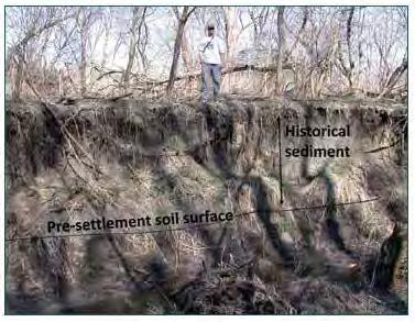
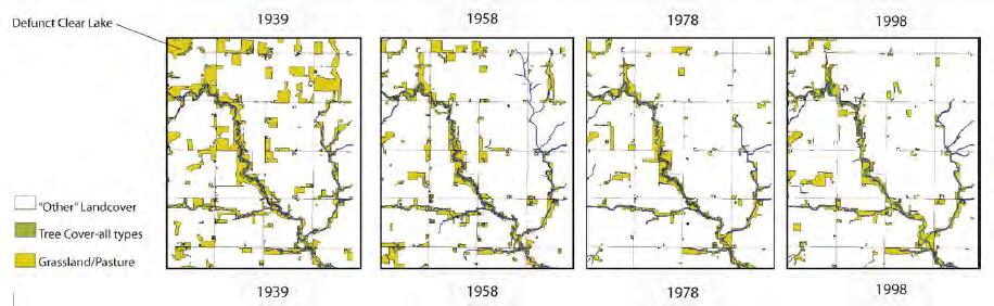
20 Legacy Sediment Mid 1800 s 1860 s 1930 s 1930 s 1980 s 1980 s - current Source: James 2013
21 Recent assessments Getting Into Soil & Water 2012 Tomer - 70 tons/ac of soil eroded from uplands, deposited on average 2.6 ft of sediment into river valley of South Fork Iowa River Getting Into Soil & Water 2014 Filstrup, Heathcote & Downing an average of 70 tons/ac of soil lost from natural lake watersheds since 1850, 75% of that since 1950 This is from Des Moines Lobe watersheds
22
23 What is the current status of our fish habitat?
24 How do we assess fish habitat? At a national scale, an analysis of fish assemblage and human landscape disturbance data was conducted to detect fish response to disturbances. The results, completed in 2015, allow inferences of fish habitat condition at the individual stream reach/catchment scale from landscape data.

25 Identifying Disturbances To Fish Habitat
26 Landscape Data Intensity of urban land use (low, medium, high) Population density; Water withdrawal Impervious surface, road length, road crossings Dams and fragmentation metrics Pasture/hay land use; Cultivated crops land use Nutrient and sediment pollution Mines, Toxics release inventory sites National pollution discharge elimination system sites EPA superfund national priorities sites

27 Iowa s results
28 Recent assessments Gelwicks, % of substrate samples taken in Iowa rivers are silt or sand 40% of streambank area has no vegetation, bare soil
29 So, some WQ parameters are getting better, but fish and fish habitat aren t what s up with that?
30 Stream Function it s the watershed! Harman, W., R. Starr, M. Carter, K. Tweedy, M. Clemmons, K. Suggs, C. Miller A Function- Based Framework for Stream Assessment and Restoration Projects. US Environmental Protection Agency, Office of Wetlands, Oceans, and Watersheds, Washington, DC EPA 843-K
31 What does reducing nutrients do? The Iowa Nutrient Reduction Strategy is a science and technology based framework to assess and reduce nutrients to Iowa waters and the Gulf of Mexico. It is designed to direct efforts to reduce nutrients in surface water from both point and nonpoint sources in a scientific, reasonable and cost effective manner. The Gulf Hypoxia Action Plan establishes a goal of at least a 45% reduction in total nitrogen and total phosphorus loads. The strategy will also intensify efforts to address nutrient related water quality problems in Iowa s waters that negatively impact beneficial water uses enjoyed and required by all Iowans. Source: Iowa Nutrient Reduction Strategy, 2016


32 What do those goals mean in Iowa? Iowa Nutrient Reduction Strategy 45% reduction in Total Nitrogen export 45% reduction in Total Phosphorus export
33 What is an appropriate starting point? Harman, W., R. Starr, M. Carter, K. Tweedy, M. Clemmons, K. Suggs, C. Miller A Function- Based Framework for Stream Assessment and Restoration Projects. US Environmental Protection Agency, Office of Wetlands, Oceans, and Watersheds, Washington, DC EPA 843-K
34 How are we going to improve fish habitat?
35 What is an appropriate starting point? Harman, W., R. Starr, M. Carter, K. Tweedy, M. Clemmons, K. Suggs, C. Miller A Function- Based Framework for Stream Assessment and Restoration Projects. US Environmental Protection Agency, Office of Wetlands, Oceans, and Watersheds, Washington, DC EPA 843-K

36 Current Hydrology
37 Current Hydraulics
38 The Iowa Angle water quality, not fish The Iowa Water Quality Initiative was established in to help implement the Iowa Nutrient Reduction Strategy, which is a science and technology based approach to achieving a 45 percent reduction in nitrogen and phosphorus losses to our waters. The strategy does not address fundamental alterations to stream functions in terms of hydrology, hydraulics or geomorphology. Without accounting for these ecosystem issues, minimal progress will be made in restoring fish habitat or attaining measureable improvements biologically (fish).


")
39 South Skunk River & Keigley Branch (from C. H. Kegley, 1936)


40 Keigley Branch, 1930s, 2017


41 Iowa River at Dows, 1909, 2017


42 Iowa River at Dows, 1930s, 2017


43 Iowa River below Dows, 1909, 2017


44 Iowa River below Dows, 1930s, 2017


45 Iowa River above Alden, 1909, 2017


46 Iowa River above Alden, 1930s, 2017


47 Green s Creek (Grays Creek) 1907, 2017


48 Grays Creek, Cherokee, 1930, 2017

49 Grays Creek, Cherokee, Sept. 2017

50 Grays Creek, Cherokee, Sept. 2017

51 Rapids on Mill Creek, 1907, 2017


52 Mill Creek near Cherokee, 1930s, 2017

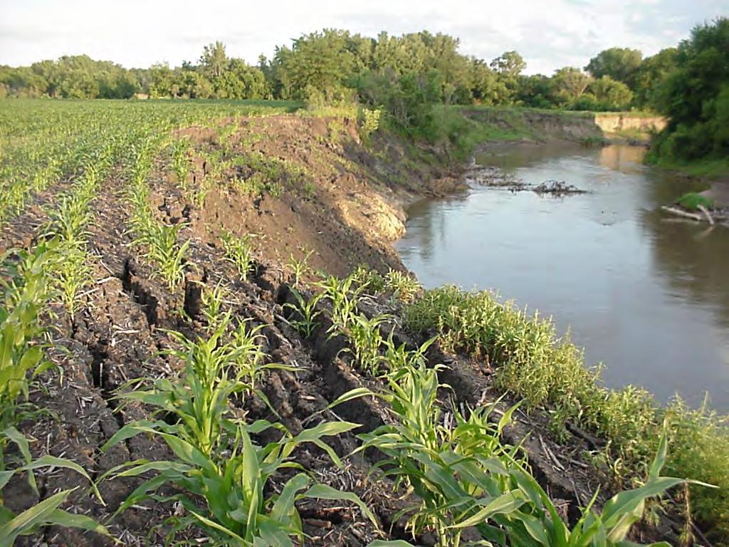
53 Mill Creek near Cherokee, Sept. 2017

54 Mill Creek near Cherokee, Sept. 2017

55 Mill Creek near Cherokee, Sept. 2017

56 Little Sioux River, Cherokee, 1907, 2017

57 Little Sioux River at Cherokee, Sept. 2017


58 Little Sioux River, Cherokee, 1930s, 2017

59 Little Sioux River at Cherokee, Sept. 2017

60 Little Sioux River at Cherokee, Sept. 2017
61 Today More readily available sediment and phosphorus next to streams than 100 years ago No plan to tie up those sources via coordinated riparian restoration efforts If sediment sources are tied up habitat improves!
62 2008 Extreme Flooding on South Fork Iowa River Small streams lost 1.1 metric tons/m of stream length, and widened 0.5 to 1.1 m Higher order streams lost 8.1 metric tons/m of stream length, and widened by more than 4.4 m Smaller order streams with permanent riparian vegetation had less bank erosion Riparian management may benefit the maintenance of stream corridors even under extreme flooding. Source: Tomer and Van Horne, 2017
63 Lake Delhi effect - Original v. Degraded v. Restoration Parameter Pre-failure Dam failure Reconstruction (2016, one year) Average depth 0.75 meters 0.39 meters 0.48 meters % Coarse Substrates 85% 18% 60% Width-Depth ratio Smallmouth Bass Baseline Status Number: -74% Weight: -81% Number: -58% Weight: -41%
64 Where are we trying to go? We are starting halfway up the pyramid, but the foundation is cracked and falling in Hydrology and hydraulics are broken, unstable Stabilize the foundation flows, substrates Chemical improvements will have limited success in improving biology/aquatic life without addressing physical habitat and hydrology

65 Where are we trying to go? Fish? WQ -reduce N & P Geomorphology reduce sediment, improve fish habitat Hydraulics reconnect floodplains Hydrology restore consistent flow regimes
66 Questions?