VII. Transportation A. ROADS
|
|
|
- Justin Manning
- 5 years ago
- Views:
Transcription
1 VII. Transportation Baytown Township is served by a combination of State, County and local roads. The Existing Transportation System and Functional Classification System Map (Exhibit 15A) indicates the road system of Baytown Township and the functional classification of each existing road as determined by the Metropolitan Council. Classification of streets and highways is the first step in preparing a coordinated transportation plan. Functional classification involves the determination of what function each street or highway should perform before determining street widths, speed limits, intersection control or other design features. The attractiveness of functional classification assures that non-transportation factors such as land use and development are taken into account. A. ROADS The Functional Classification System consists of four (4) classes of roadways within the seven-county metropolitan area; principal arterials (which include interstate freeways), minor arterials, collector streets and local streets. Definitions of each of the four (4) classes are as follows: Principal Arterials - A street or highway which provides for high speed travel and no direct land accesses. Highways should be designated as a fully controlled access facility. They are used to connect all of the subregions to the metropolitan center. They also connect the metropolitan area to outstate centers. Minor Arterials - A street or highway which connects adjacent subregions. Minor arterials are primarily oriented toward the provision of submetropolitan mobility and any land access should be oriented to public streets and major generators rather than closely spaced driveways onto the street. Baytown Township Page Comprehensive Plan
2 Collector - A street which functions to collect traffic from local streets and move it to minor arterials and other collectors. Collector systems provide access to commercial, industrial and high density residential development. Local - A street which functions to provide access to land with neighborhoods rather than to car traffic though. There are no principal arterials within Baytown Township s limits. State Highway 36 is classified as a principal arterial. State Highway 36 is a four lane divided highway with partially controlled access. This highway runs east-west and terminates at the St. Croix River. This highway is located along the northern border of Oak Park Heights. State Highway 5 (Stillwater Boulevard North) from the intersection of Highway 36 runs southwest though the northwestern portion of the Township. This stretch of road functions as a minor arterial. Highway 95 (St. Croix Trail North), on the eastern edge of the Township, functions as a minor arterial and provides access north and south. County State Aid Highway (CSAH) 14 and the small stretch of CSAH 15 (Manning Avenue) both function as minor arterials. CSAH 14 provides access east and west though the Township, while CSAH 15 provides convenient access to the south and connects with State Highway 5 (Stillwater Boulevard North) at its northerly terminus. CSAH 21 (Stagecoach Trail North) runs north and south through the Township and functions as a minor arterial. As the remaining Anderson property west of CSAH 21 and south of CSAH 14 develops for the St. Croix Preparatory Academy, turn lanes for the entrance to the school will be needed. In 1996, County Road 67 (Osgood Avenue North) was reclassified as CSAH 24. This road runs northerly from CSAH 14 to State Highway 36. CSAH 24 functions as a minor arterial. Northbrook Boulevard runs north-south between CSAH 14 and the northerly stretch of Oakgreen Avenue and functions as a collector. The southern stretch of Oakgreen Avenue (CSAH 65) runs from 30th Street to CSAH 14 providing north-south access within the Township and functions as a collector. 30th Street runs along the southern border between Baytown Township and West Lakeland Township providing east-west access through the communities. 30th Street functions as a collector. All other roads not specifically mentioned above or identified in the table below are considered local roads. The Existing Transportation System and Functional Classification System Map, (Exhibit 15A) identifies these features. Baytown Township Page Comprehensive Plan
3 Table 6: Road Classifications Name Alternative Name Function General Direction State Highway 5 Stillwater Boulevard Minor N-S North Arterial State Highway 95 St. Croix Trail North Minor N-S Arterial County State Aid Highway (CSAH) 15 Manning Avenue North Minor N-S Arterial County State Aid Highway (CSAH) 14 40th Street North Minor E-W Arterial County State Aid Highway (CSAH) 24 Osgood Avenue North Minor N-S Arterial County State Aid Highway (CSAH) 21 Stagecoach Trail North Minor N-S Arterial County Road 65 Oakgreen Avenue North Collector N-S 30th Street North Collector E-W Northbrook Boulevard North Collector N-S The total mileage by classification is estimated as follows: Minor Arterial Collector 9.1 miles 6.3 miles In 2004, a Road Inventory was completed for the Township. The inventory identified miles of bituminous surfaced roads within the Township. Since this inventory was completed, one additional section was paved on Neal Avenue from 30th Street North which was approximately 0.5 miles of additional bituminous surfaced roads. The Township has few gravel roads left within the Township and requires new developments to provide bituminous surfaced roads. Local Roads miles of bituminous surface 0.6 miles of aggregate surface 1. Traffic Volumes Washington County recently updated current and future estimates of average daily traffic volumes for arterials and collectors in Washington County. These estimates are based on traffic volumes in 2007 and forecasted to Exhibit 13 shows Existing Traffic in Baytown Township in The highest volumes are on CSAH 15, with volumes ranging from 9,900 where CSAH 15 enters Baytown from the south to 10,700 where it junctions with CSAH 14. CSAH 14 has traffic ranging from 5,070 at the west end of the Township to 4,100 where it meets CSAH 24. CSAH 21 carries about 6,000 vehicles per day in Baytown Township Page Comprehensive Plan


4 Baytown Township. STH 95 carries about 12,000 vehicles per day in Baytown. Exhibit 13: Washington County Existing Traffic Volumes In comparing 2007 volumes with forecasted 2030 volumes, CSAH 15 will see a substantial growth in traffic, to 15,400 vehicles in 2030 as shown on Exhibit 14. CSAH 14 will increase to 8,000 vehicles per day on its west end to 6,100 vehicles. CSAH 21 will increase to 9,400 vehicles per day, while County Road 65 will have 4,200 vehicles per day. CSAH 13 will increase to 11,200 vehicles per day. Overall, all arterials and collectors will increase in traffic due to growth north and east of Baytown. Baytown Township Page Comprehensive Plan

5 Exhibit 14: Washington County 2030 Forecasted Traffic Volumes The County prepared a list of improvements for both arterials and collectors in the County. This list extends to 2030, although it is updated periodically and can change in the future. Aside from the St. Croix River Bridge Crossing, which is projected for between 2024 and 2030, there are no Mn/DOT improvements that will affect Baytown. It is expected that with those improvements, more traffic will continue west on Highway 36, although substantial traffic will continue to cut through the Township either on STH 95 or STH 5 and CSAH 15. At this point, there are no planned improvements to County Roads in Baytown during this period. Baytown Township encourages the County to address transportation safety issues on County roadways, especially as traffic volumes increase. 2. Proposed Connections As a community develops, it normally tries to connect local roads in order to provide safe access and egress from subdivisions. Exhibit 15B, Proposed Connections and TAZ Boundaries Map, shows possible future local roadway connections for the Township. 3. Transportation Analysis Zones (TAZs) Transportation Analysis Zones (TAZs) are a planning tool used to determine how land use relates to the transportation system. The population, household and employment forecasts are allocated to the TAZs that share the Township s geography. These allocations are detailed in Table 7-9. The Township used Washington County s transportation modeling data to complete this portion of the Plan Baytown Township Page Comprehensive Plan
6 Update and the TAZ data described below indicates estimates and forecasts derived from Washington County. TAZ 1231 encompasses the northwestern corner of the Township from north of 40th Street, north of Olinda, north of Osgood to the Township s borders, with the exception of the small portion of land east of Highway 5, which is included in TAZ 1129 in Lake Elmo. TAZ 1231 does include a small portion of Oak Park Heights, north of Township borders. TAZ 1195 includes the area from Manning Avenue to Oakgreen Avenue and from 40th Street to 30th Street. TAZ 1195 also includes area directly south of this into West Lakeland Township to County Road 10. TAZ 1196 includes everything from Oakgreen to Olinda to Osgood to 50th Street and all areas south of 50th and to the Township s eastern border with Bayport and the St. Croix River. The exception is a very small portion of the prison farm land near Bayport which is in TAZ TAZ 1196 also includes area in West Lakeland Township directly south of this to County Road 10 then along County Road 21 then to 22nd Street. Exhibit 15B, the Proposed Connections and TAZ Boundaries Map can be referenced for visual representation of the TAZ boundaries. The TAZ data in the table below shows only Baytown s population, household and employment estimates. Table 7: 2005 TAZ Data 2005 Washington County TAZ Population Households Retail Employment Non-retail Employment TOTAL 1, TOTAL 1, Metropolitan Council Totals* 1, Source: Washington County, Metropolitan Council, TKDA * 2005 totals for Metropolitan Council represent the midpoint of 2000 and 2010 forecasts. Baytown Township Page Comprehensive Plan
7 Table 8: 2005 to 2030 Growth Data 2005 to 2030 Growth Washington County TAZ Population Households Retail Employment Non-retail Employment TOTAL TOTAL Metropolitan Council Totals Source: Washington County, Metropolitan Council, TKDA * 2005 totals for Metropolitan Council represent the midpoint of 2000 and 2010 forecasts. Table 9: 2030 TAZ Data 2030 Washington County TAZ Population Households Retail Employment Non-retail Employment TOTAL 2, TOTAL 2, Metropolitan Council Forecasts (2030) 2, Source: Washington County, Metropolitan Council, TKDA 4. Access Management The Township works with Washington County to regulate the number of access points to County roads and with Mn/DOT regarding access onto State and U.S. Highways. In order to promote a safe and efficient transportation system, spacing and access guidelines are incorporated into Baytown s subdivision regulations. Guidelines describe access spacing on principle arterials, minor arterials, collectors and local roads. The land use associated with proposed access points also determines the appropriate spacing. 5. Pedestrian and Bicycle Facilities One regional trail corridor is planned alongside the Township s western border. The Township considers pedestrian accommodations along new local roads through the development review process. Planning for trails is discussed in the Parks and Trails section of the Plan. Baytown Township Page Comprehensive Plan
8 OAKGREEN AVE N 53RD ST N CSAH 24 40TH ST N CSAH 14 MCDONALD OVERLOOK DR N 44TH ST N NEAL AVE N OSGOOD AVE N OMAHA AVE N 30TH ST N 40TH ST N OLDFIELD AVE N County Road 65 NORMAN AVE N!(!(!(!(!(!(!(!(!(!(!(!(!( Oak Park Heights West Lakeland Township Bayport SAINT CROIX TRL N Union Pacific Railroad BAYTOWN LN N STAGECOACH TRL N PARIS AVE N Bus Route 294 NOVAK AVE N MONARDA AVE 51ST ST N NEAL AVE N MUIR AVE N 50TH ST N BAYTOWN TOWNSHIP Existing Transportation System and Functional Classification System DATE: MAY 2009 HIGHWAY 95 CSAH 21 PINECROFT AVE N 51ST STREET CT N 53RD STREET PL N Lake Elmo 49TH ST N 53RD STREET CT N PINECROFT CT N 49TH ST N NORMANDY CT N NORTHBROOK CT N NORMANDALE AVE N 48TH ST N NORTHBROOK BLVD N MCDONALD DR N HIGHWAY 5 OLINDA BLVD N 47TH ST N 47TH ST N MCDONALD DRIVE CIR N STILLWATER BLVD N 47TH STREET CT N MCDONALD DRIVE PL N 45TH ST N MCDONALD DR CT N 44TH ST N 44TH ST N ODEGARD CT N ODEGARD AVE N MCFAIR AVE N PARIS AVE CT N MORNING DOVE AVE CT N CSAH 14 OAKGREEN AVE N Union Pacific Railroad 34TH ST N OASIS AVE N NORCREST AVE N CSAH 15 MANNING AVE N MORNING DOVE AVE N MENDEL AVE N 30TH STREET CIR N NEAL AVE N 30TH ST N Sources: Metropolitan Council, Washington County, TKDA K:\gis\BAYTOWN\Exhibit15A-ExistingTransportationSystem.mxd Legend Municipal Boundaries Lakes Parcels Lake Elmo Airport Local Street Gravel Roads Right of Way Railroad Right of Way Bus Routes!( Bus Stops Functional Classification System Minor Arterial Collector Exhibit 15A Miles
9 OAKGREEN AVE N 53RD ST N CSAH 24 40TH ST N CSAH 14 MCDONALD OVERLOOK DR N 44TH ST N NEAL AVE N OSGOOD AVE N OMAHA AVE N 30TH ST N 40TH ST N OLDFIELD AVE N CSAH 65 NORMAN AVE N!(!(!(!(!(!(!(!(!(!(!(!(!( Oak Park Heights West Lakeland Township Bayport SAINT CROIX TRL N Union Pacific Railroad BAYTOWN LN N STAGECOACH TRL N PARIS AVE N NOVAK AVE N MONARDA AVE 51ST ST N NEAL AVE N MUIR AVE N 50TH ST N BAYTOWN TOWNSHIP Proposed Connections and TAZ Boundaries DATE: MAY 2009 HIGHWAY 95 CSAH 21 PINECROFT AVE N 51ST STREET CT N 53RD STREET PL N Lake Elmo 49TH ST N 53RD STREET CT N PINECROFT CT N 49TH ST N NORMANDY CT N NORTHBROOK CT N NORMANDALE AVE N 48TH ST N NORTHBROOK BLVD N MCDONALD DR N HIGHWAY 5 OLINDA BLVD N 47TH ST N 47TH ST N MCDONALD DRIVE CIR N STILLWATER BLVD N 47TH STREET CT N MCDONALD DRIVE PL N 45TH ST N MCDONALD DR CT N 44TH ST N 44TH ST N ODEGARD CT N ODEGARD AVE N MCFAIR AVE N PARIS AVE CT N MORNING DOVE AVE CT N CSAH 14 OAKGREEN AVE N Union Pacific Railroad 34TH ST N OASIS AVE N NORCREST AVE N CSAH 15 MANNING AVE N MORNING DOVE AVE N MENDEL AVE N 30TH STREET CIR N NEAL AVE N 30TH ST N Sources: Metropolitan Council, Washington County, TKDA K:\gis\BAYTOWN\Exhibit15B-ProposedTransportationSystem.mxd Legend Municipal Boundaries Lakes Parcels Lake Elmo Airport Local Street Gravel Roads Right of Way Railroad Right of Way Bus Routes!( Bus Stops Exhibit 15B Proposed Connections 2007 TAZ Boundaries Miles
10 B. AIRPORTS The Lake Elmo Airport is a general aviation airport owned by the Metropolitan Airport Commission (MAC) and operated by MAC for public use. The Lake Elmo Airport is located in Washington County, approximately 12 miles east of the downtown St. Paul business district. It lies one mile east of downtown Lake Elmo, within Baytown Township, and is bordered by West Lakeland Township and the City of Lake Elmo. The airport encompasses approximately 640 acres, approximately 560 acres of which is in Baytown Township. The remaining 80 acres are in West Lakeland Township to the south of 30th Street. The airport consists of a paved and lighted mainwind NW/SE runway and a paved NE/SW crosswind runway, including parallel taxiways. The primary runway is 2,850 feet long and 75 feet wide. The crosswind runway is 2,497 feet long and 75 feet wide. The Lake Elmo Airport serves as a reliever to the Minneapolis-St. Paul International Airport. Service is provided to operators of single engine and light twin engine, propeller craft primarily for training, pleasure and business flying activities. Capacity of the existing facility at the Lake Elmo Airport is estimated at 230,000 annual operations. Aircraft operations for 2005 are estimated at 57,667. From an airside standpoint, the airport is at 25% capacity. Baytown Township Page Comprehensive Plan
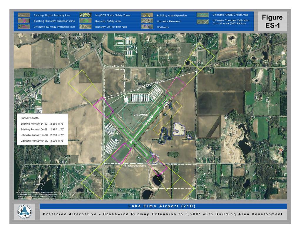
11 1. The Lake Elmo Airport Long-Term Comprehensive Plan The long term comprehensive plan update is a 20-year planning document, extending from 2005 to The last plan update for Lake Elmo was completed in The current plan was completed in June The major recommendations of the 2008 Plan include: Relocating the primary runway to achieve a 3,300-foot length, with an ultimate extension to 3,900 feet New hangar area development Extension and lighting of the crosswinds runway to 3,300 feet Construction of a compass calibration pad In addition, other recommendations included the realignment of the north entrance road and installation of precision approach path indicators. To date, the compass pad has been constructed and the entrance road has been realigned. The Preferred Alternative of the Crosswind Runway Extension to 3,200 with Building Area Development from the Lake Elmo Airport 2008 Comprehensive Plan is shown in Exhibit 16. In comparison to the other MAC-owned Reliever Airports, runway lengths for both the primary and crosswind runways are the shortest in the system. The FAA-recommended runway length needed to accommodate 95% of the aircraft for this category airport is 3,280 feet. To accommodate 100% of the aircraft, a runway length of 3,890 feet is needed. Non-Aeronautical Operations are discussed in the 2008 Long-Term Comprehensive Plan for the Lake Elmo Airport. In the future, MAC, in conjunction with Township officials, may consider leasing areas for non-aviation uses to generate additional revenue. Sections of airport land designated as potential areas of development are shown in Exhibit 17. Uses that would be permitted here would be compatible with airport uses such as commercial or industrial businesses. The provision of sewer and water services to these areas would be required. MAC indicated that the Lake Elmo Airport would be the last airport considered for this type of development. The areas identified in Exhibit 17 are discussed only for the purpose of communicating potential development areas that the Township would consider for other uses. If and when the MAC decides to develop specific parcels for non-aviation Baytown Township Page Comprehensive Plan
12 uses, the MAC will amend its plan and the Township will review land uses at that time. The following elements for the 20-year planning period describe the recommendations for the airports development along with estimated timeline and estimated costs for each recommendation. Table 10: Lake Elmo Airport 20-Year Planning Recommendations Recommendation Timeline Estimated Cost Pursue Installation of AWOS/ ASOS through Immediately $0 Mn/DOT Construct new hangar area to accommodate the 0 5 Years first $2,600, needs phase 5 15 Years final phase Construct a Full Parallel Taxiway in conjunction In conjunction with $900,000 with new hangar area new hangar area Pursue agreements with the communities to 0 5 Years $0 provide limited S&W services to the airport Review alternatives and feasibility of serving hangar area(s) with a public or private systems 0 5 Years $900,000 - $1,700,000 Reconstruct the Existing Primary Runway Years $1,500,000 Pavement Extend Crosswind Runway 4-22 and Taxiway to 0 5 Years $1,200,000 3,200 Feet, including Runway Lighting and PAPI systems Reconstruct the Existing Crosswind Runway Years $1,300,000 Length Continue to show the need for a relocated Primary Runway in plan, and include the future approach areas in the upcoming zoning effort Beyond 20-year planning period Source: Long-Term Comprehensive Plan Lake Elmo Airport (21D), June Environmental Considerations that will require study as part of any implementation of the proposed concepts at the Lake Elmo Airport include noise, wetlands, and sanitary sewer and water facilities. The following summaries are taken from the Executive Summary of the Draft Lake Elmo Airport Long-Term Comprehensive Plan. Exhibit 18 attached to this Plan identifies the preferred alternative Noise Contours discussed below. a. Noise. MAC has prepared a 2005 noise contour for Lake Elmo Airport, as well as 2025 noise contour for the preferred alternative. The 70, 65 and 60 decibel noise level (DNL) contours are shown for both scenarios. The noise contours also show a 55 DNL contour. The 55 DNL contour is depicted because the airport lies mostly outside of the Metropolitan Urban Services Area (MUSA), and therefore, a 55 DNL contour is required per the Metropolitan Council. $0 Baytown Township Page Comprehensive Plan
13 b. Sanitary Sewer and Water. The Lake Elmo Airport currently lies outside of the MUSA boundary. However, the Metropolitan Council Environmental Services (MCES) agency has requested that MAC provide sanitary sewer and water services for all of the Reliever Airports, including Lake Elmo. Therefore, any hangar area expansion proposals must review the needs and feasibility of providing these services. The plan recommends the following for installation of sanitary sewer and water facilities at Lake Elmo: (1) Pursue an agreement with the City of Lake Elmo and Baytown Township for the provision of sanitary sewer and water to the airport from the proposed development adjacent to airport property or via other means. (2) Continue to study the costs, benefits and feasibility of serving the airport with sanitary sewer and water versus well and septic systems. c. Wetlands. There are wetlands in existence at the Lake Elmo Airport. Any of the concepts implemented at the airport will be studied closely to prevent wetland impacts. If wetlands are unavoidable, designs will be adjusted as much as possible to minimize impacts. The Township will participate in review and comment on any Environmental Assessments that are undertaken as a result of the proposed airport expansion projects. Baytown Township Page Comprehensive Plan
14

15 Non Aeronautical Opportunities Lake Elmo Airport

16
17 2. Planning Considerations Because the Township is within part of the Influence Area of the Lake Elmo Airport, it is affected by several planning considerations potentially involving the following items: airport zoning, environmental mitigation, airport development and economic impacts, ground access needs, infrastructure requirements, and general land use compatibility. As per the Metropolitan Systems Statement, one aviation planning consideration which the Township must address in its comprehensive plan is airspace protection. The protection is for potential hazards to air navigation including electronic interference. The Township s Ordinances must also include regulations to control height of structures, especially when conditional use permits apply. Requirements regarding the notification to the Federal Aviation Administration (FAA) defined under code of federal regulations CFR- Part 77, using FAA Form Notice of Proposed Construction or Alteration shall be implemented when required. Currently, there are not any structures exceeding 200 feet in height in the Township. Any new transmission or radio and television tower would be allowed only under a conditional use permit. Also, it will only be allowed if the proposed structure will not constitute an obstruction to air navigation or otherwise adversely impact the Metropolitan airport system. Baytown Township Page Comprehensive Plan
18 3. Airport Zoning Standards In 1979, the State of Minnesota adopted rules governing airport zoning standards (Minnesota Rules to ). These are minimum standards for the zoning of public airport and affect airspace, land use safety, and noise sensitivity. The county and Township have the right to be more restrictive than these standards. Baytown Township and Washington County have adopted airport zoning which is implemented through an Airport Overlay District. The Airport Overlay District establishes regulations that control the types and extent of land development adjacent to and near the airfields so as not to impede present and future air operations of public benefit and to protect the public from hazards, air traffic noise, and other disturbances. The District limits the development and future construction to a reasonable height and use so as not to constitute a hazard for planes operating from the airfields. 4. Airspace Zones Airspace zones are shown in Exhibit 19. There are five airspace zones that are relevant at the Lake Elmo Airport: 1) primary zone, 2) horizontal zone, 3) conical zone, 4) approach zone, and 5) transitional zone. Essentially, the floor of each block of zoned airspace represents the maximum allowable height of an obstruction in that area. No structure or tree can be allowed to penetrate into those zones. 5. Land Use Safety Zones There are three zones on the surface surrounding an airport that have use restrictions that would compromise safety: Safety Zones A, B and C. Safety Zone A extends outward from the Primary Surface two-thirds the length of the runway (existing or planned). Safety Zone B extends beyond Zone A by one-third of the runway length (existing or planned) and Safety Zone C extends beyond A and B and is enclosed with the perimeter of the horizontal zone (Exhibit 20). The intent of these zones is to restrict uses that would be hazardous to the operational safety of aircraft operating to or from an airport. Limiting population and building densities in these areas is the method used to protect life and property. In Zone A, no structures or powerlines are permitted. Permitted uses in Zone A include agriculture, raising of livestock, cemeteries, etc. In Zone B, development density must have at least a three acre minimum. Specifically prohibited in Zone B are schools, churches, hospitals, theaters, stadiums, camp grounds, etc. The intent is to prohibit places of public or semi-public assembly in this zone. Zone C has only general restrictions: no uses can be permitted that interfere with ground and Baytown Township Page Comprehensive Plan
19 aircraft navigation and communication or that make it difficult for the pilot to distinguish between runway lights and other lights, or that otherwise endanger maneuvering of the aircraft. (See MR to for a detailed description of these limitations.) The intent of safety zoning is to balance the public interest in safety for people on the ground and in the air, while considering the public interest of maintaining existing land uses. State Statute provides for the removal of land uses and structures which present a most severe hazard to persons in the air or on the ground. Land uses in these zones must be consistent with Federal Aviation Administration and Minnesota Department of Aeronautics rules and regulations. 6. Best Management Practices from the Airport Compatibility Manual In September 2006, the Minnesota Department of Transportation/ Office of Aeronautics adopted the Airport Compatibility Manual. The Metropolitan Council supports implementation of the Best Management Practices (BMPs) identified in this manual as a means of meeting regional policy. The BMPs identified include the following: Incorporate Airport Zoning Ordinances into Local Development Controls Allow Mn/DOT to Review Major Development Applications and Variance Requests Modernize and Expand the List of Compatible Land Uses in Local Airport Zoning Ordinances Consider Regulating Incompatible Land Uses in Safety Zone C The Township will consider these BMPs when reviewing land uses in areas impacted by the Lake Elmo Airport. 7. Joint Zoning Board A Joint Zoning Board is intended to be formed, initiated by MAC, intended to address planning, density and use restrictions in the extended airway zone of the Lake Elmo Airport. Members of the Board will consist of representatives from Lake Elmo, West Lakeland Township, Baytown Township, Washington County, and MAC. Mn/DOT indicates that the purpose of the Board is to develop and adopt an airport zoning ordinance which will meet Mn/DOT airport zoning standards. The Board will establish land use safety zones, address height requirements in these areas, and assist with compliance with FAA notification processes associated with proposals within the these zones. It is anticipated that this Board will be formed in Baytown Township Page Comprehensive Plan
20 8. Obstruction to Public Airport The Minnesota Rules to establishes the criteria for determining obstructions to air navigation. The most relevant issue is the maximum obstruction height of 200 feet with three miles of a runway. There are however, a number of variables that have a profound effect on the various height possibilities. It is imperative that any planned structure in the airport vicinity be reviewed with the requirements of Minnesota Rules to Seaplane Operations Under Mn/DOT Office of Aeronautics, MR , seaplane operations are permitted on the surface waters of the St. Croix River. Baytown Township Page Comprehensive Plan
21
22
23 C. RAILROADS Two railroads pass through the Township. Both lines are owned by the Union Pacific Railroad. The first line passes along the southeastern corner of the Township in a north-south direction and serves Anderson Windows and the Allen S. King Plant in the City of Bayport. This line splits south of the Township and branches off to form the second line passing through the center of the Township going north to intersect at CSAH 14 and CSAH 24 then running in a southwesterly direction past CSAH 15 out of the Township. There are approximately 5.3 miles of track within the Township. D. PUBLIC TRANSPORTATION According to the System Statement issued in September 2005 by the Metropolitan Council, Baytown Township is within Market Area IV. Market IV areas have land use patterns that tend to have the lowest concentration of housing and jobs. Regional transit service options for these areas include dial-a-ride, volunteer driver programs, and ridesharing. Dial-a-ride services are provided by Human Services Inc. Baytown Township is within the Metropolitan Council s Transit Taxing District. The transit taxing district is the area in which all taxable property was assessed a tax to be used for payment of transit and paratransit services per Minn. Stat Transit services include regular route bus services and paratransit services include dial-a-ride bus service such as Metro Mobility. The figure below depicts the extent of the transit taxing district surrounding Baytown. Baytown Township Page Comprehensive Plan

24 Exhibit 21: Transit Taxing District Area Transit options can assist in minimizing vehicular impact to local roads and provide a transportation alternative for Township residents. There are two park and ride facilities in proximity to the Township. The first is located in the City of Lake Elmo near the intersection of Laverne Avenue North and Highway 5. A second facility is located in the City of Stillwater at the St. Croix Valley Recreation Center. In 2030, this facility is planned for expansion to accommodate another 200 parking spaces. These regional facilities serve residents of the Township. The Township is also served by bus (Route 294) which provides service from Stillwater to downtown St. Paul via Lake Elmo and Oakdale. There are transit stops in the Township for Route 294 along Highway 5. To provide local service options, the Township is receptive to the location of a carpool/vanpool or park and ride lot within the Township. This facility would be encouraged to be located next to state or county roads, particularly along State Highway 5 (Manning Avenue), to encourage local transit service near the existing regional transportation network. E. RIVER USEAGE Surface waters of the St. Croix River are used primarily for pleasure boating. Occasional barge traffic takes place on the St. Croix River, primarily for the purpose of providing coal to the Northern States Power plant in Bayport. Under Metropolitan Division of Aeronautics, Aero 13, seaplane operations are permitted on the surface waters of the St. Croix River. Baytown Township Page Comprehensive Plan
25 VIII. Housing The Township s Goals and Policies Section states the Township s intent to retain low-density, single family residential development along with maintaining the rural character of the Township. In addition, the Township will promote and maintain suitable and moderate cost housing in the Township. In order to meet these goals, the Township must assess current housing within the Township and address housing needs for the community through The Metropolitan Council requires communities to include in the comprehensive plan, a housing element and implementation program that address existing and projected housing needs. Baytown Township s housing stock consists largely of single family residential homes. According to the Census data for the year 2000, 99.2% of homes were classified as one-unit detached homes. Below are tables outlining the age and value of housing in the Township. This information indicates that 58.5% of housing in the Township was built after 1980, illustrating that the Township s housing stock consists of newer single family residences. Also, 65.4% of the Township s housing is above $200,000. Table 11: Age of Housing YEAR STRUCTURE Number Percent BUILT 1999 to March to to to to to to or earlier Total Housing Units Source: U.S. Census Bureau, Year 2000 data Baytown Township Page Comprehensive Plan
26 Table 12: Value of Housing VALUE Number Percent Less than $50, $50,000 to $99, $100,000 to $149, $150,000 to $199, $200,000 to $299, $300,000 to $499, $500,000 to $999, $1,000,000 or more Median (dollars) $275,000 Source: U.S. Census Bureau, Year 2000 data A. WASHINGTON COUNTY HOUSING STUDY The Comprehensive Housing Needs Assessment for Washington County was recently updated by Maxfield Research, Inc. This study examines current housing within the County and addresses housing needs for the County through The study discusses Baytown Township as a part of the Stillwater Area assessment along with the communities of Stillwater Township, Stillwater, Oak Park Heights, and Bayport. 1. Trends in Housing Baytown will be subject to housing trends similar to those of all of Washington County and the Metropolitan Area. These trends are likely to influence Washington County and Baytown Township: a. Demand for new housing in Washington County will remain strong, and be driven almost exclusively by household growth. b. About 85 percent of housing demand will be for single family dwelling units, about 15 percent for multi-family housing units, including senior housing. c. Senior demand for housing will increase after 2020 when baby boomers reach their mid-70 s. Between 2020 and 2030, 68 percent of the overall rental demand will be for senior units (2,800 units). d. Few new single family homes priced under $325,000 are projected to be built to satisfy demand from moderate income buyers. e. Because of high costs of new construction (land, labor and materials), very few of the buyers for new single family homes are likely to be first time buyers. Baytown Township Page Comprehensive Plan
27 f. With the aging of the baby boomers, the greatest growth in Washington County from 2007 to 2020 will be among people ages 55 to 74. g. In 2000, 77 percent of Washington County s households were families, compared to 67 percent of the Metro Area s. This difference is caused by the high number of new families moving to the County compared to younger singles. B. BACKGROUND * Source: Comprehensive Housing Needs Assessment for Washington County, Maxfield Research, Inc, Housing as a Major Land Use Prior to 1960, farms were the dominant land use in the Township while farming is still important, rural residential housing has become the dominant land use. As agriculture declines, the Township expects that rural residential housing will be more important as a land use in the Township. 2. Housing and Community Character Housing type related to lot size determines the character of the community. Housing types include single family detached, single family attached (townhomes), rental apartments, and seasonal homes. The Township s Goals and Policies Section states that single family detached homes will be the preferred type of housing in Baytown Township. The Township recognizes that as the population of the Township ages, additional opportunities for the elderly should be provided. The Boutwell s Landing development (Presbyterian Homes) is expected to expand its development into the Township within the next 10 years. This expansion will be the Township s first experience with multifamily, attached housing. 3. Housing is an important element of the Township tax base As housing has increased in the Township, it has become the major source of taxable property in the Township. Without extensive commercial or industrial land uses planned, residential uses will continue to be the predominant source of revenue in the Township. 4. Housing Condition Considerations of housing condition include more than the primary structure, but also accessory buildings, outdoor storage, and Baytown Township Page Comprehensive Plan
28 maintenance efforts. These factors contribute to community character. The Township s Goals and Policies Section states that individual property owners will be encouraged to rehabilitate existing homes where needed. C. HOUSING SUPPLY 1. Number of Housing Units In 2000, there were 506 housing units in Baytown Township. Of these, the majority are single family detached homes. Before 1960, there were only 73 housing units in the Township. The majority of the growth in the Township has occurred between 1990 and 2000, when 230 of the units, or 45.5 percent of the housing units were constructed in the Township. Almost half of the Township s housing stock is less than fifty years old. The median value of housing in Baytown in 2000 was $275,000 with 78 units worth more than $500,000. The median monthly mortgage payment in 2000 was $1,702, which compares to $1,263 for Washington County and $1,165 for the Metropolitan Area. Just as housing values are much higher in Baytown than other Metro Area communities, the mortgage costs are much higher as well. 2. Housing Location The housing supply consists mostly of large, single family lots. Locations around lakes and other water features are prevalent in areas within the Township such as McDonald Lake and Cloverdale Lake. Preferences for home locations within Open Space Developments have increased. Since most of the northwest part of the Township was built out in the 1990 s, most recent development has occurred in the east central part of the Township, near Stagecoach Trail. Most of this development has been open space or clustered housing. Most areas in the northwest and central parts of the Township are already developed with only small pockets of undeveloped land remaining. The two remaining large parcels are in the southwest corner of the Township next to the Airport and in the Northeast part of the Township next to the DNR Wildlife Management Area. 3. Regional Housing Needs The Township plans to contribute to the regional housing need for higher density housing through a planned development near Boutwell s Landing in Oak Park Heights, within the Township s borders. This potential development approximates 110 housing units for seniors. Baytown Township Page Comprehensive Plan
29 Other areas of planned higher density housing have been designated within the Township near other developed areas such as Bayport and Lake Elmo in order to accommodate regional housing needs after D. HOUSING ISSUES The major housing issues facing Baytown Township over the next 25 years relate to meeting the regional housing forecasts. If the Boutwell s Landing project moves forward, the Township will meet the forecast. If not, and housing development slows, it may be difficult to meet regional forecasts. A second Township concern related to housing is maintaining the community character. The type of housing developed in the Township can affect the overall character of the community. With the 2030 Comprehensive Plan, the Township will allow multi-family housing on public sewers, which will provide life cycle housing opportunities for Township residents as they age. The location and design of this new housing type should be sensitive to the character and vision of the Township while addressing the safety, transit, and service needs of an aging population. A third metro-wide issue related to housing, will be the demand for new unit types to meet lifecycle needs, such as auxiliary housing or granny flats. The Township s Zoning Ordinance currently allows for accessory apartments, but with the aging of the baby boomers, there could be more demand for separate granny flats. E. AFFORDABLE HOUSING - REGIONAL POLICIES The Metropolitan Council defines affordable housing as a unit priced at or below 30% of gross income of a household earning 60% of the Twin Cities median family income (or $46,200 in 2005). In the year 2000, affordable housing prices were near $100,000. According to the Allocation of Affordable Housing Need by City/Township published by the Metropolitan Council, as a rural area, Baytown Township is not required to provide affordable housing to meet regional needs. However, Baytown is required to address the forecasted housing needs and provide a share of the regional household growth. A very small portion of Baytown s existing housing falls within the range considered affordable. The Township will continue to enforce its codes and ordinances to maintain the quality of this housing (including the maintenance of viable septic systems and wells), and supports the County s programs to provide affordable housing in locations that provide transportation and services that meet the needs of seniors and others living in affordable housing. Baytown Township Page Comprehensive Plan
30 IX. Surface Water Management Plan A. PURPOSE OF THE PLAN AND EXECUTIVE SUMMARY This Local Surface Water Management Plan will guide Baytown Township in conserving, protecting and managing its surface water resources. This plan has been created to meet the requirements detailed in Minnesota Statutes 103B and Minnesota Rules 8410, administered by the Minnesota Board of Water and Soil Resources. This plan is also consistent with the goals and policies of the Metropolitan Council s Water Resources Management Policy Plan, and the plans of the watershed management organizations having jurisdiction within the Township. Baytown Township is located within the geographic area of two watershed management organizations (WMO s) - the Valley Branch Watershed District and the Middle St. Croix Watershed Management Organization (Exhibit 7). The eastern area of Baytown Township drains to the St. Croix River through the Middle St. Croix WMO. The western portion of the community drains to the Valley Branch Watershed, and from there to the St. Croix River. The plans for these WMO s were approved by the Minnesota Board of Water and Soil Resources (BWSR) between 2005 and Based on the completion of the watershed plans for the watershed organizations within Baytown Township, the Township is required to complete this local surface water management plan by The Middle St. Croix WMO Watershed Management Plan will expire in The Township will need to update this LSWMP within two years of the expiration date of its local watershed plans. The Middle St. Croix WMO has completed a wetland inventory and management plan in 2005, including a functions and values assessment of wetlands within Baytown Township and other communities in the WMO. The Valley Branch Watershed District is currently completing the functions and values assessments and management plans for wetlands within that District, and is estimating completion of the wetland assessment and management plan during B. WATER RESOURCE MANAGEMENT AGREEMENTS The watershed organizations within Baytown Township have each adopted rules for the management of surface waters within their jurisdictions. While no formal agreements have been adopted regarding permitting and surface water management, the Township works cooperatively with the WMO s in communicating on development activities, and alerts landowners and developers about potential district permits or other enforcement. Baytown Township Page Comprehensive Plan
31 The Subdivision Application Process for development applications within Baytown Township describes the responsibilities of each organization included in the process. This document is included in the Appendix. Baytown Township is a member of the Middle St. Croix Water Management Organization, and has signed the Joint Powers Agreement that created and maintains the WMO. The Township will continue to cooperate with the Middle St. Croix Watershed Management Organization and Valley Branch Watershed District to enforce surface water management regulations within the community under this Local Surface Water Management Plan. C. LAND AND WATER RESOURCES INVENTORY 1. Surface Water Resources a. Valley Branch Watershed District The Valley Branch Watershed District (VBWD) drains Valley Creek, and from the creek to the St. Croix River, an Outstanding Resource Value Water. The Watershed District includes a number of subwatersheds that drain to landlocked basins (lakes or wetlands), as well as subwatersheds that drain to Valley Creek. The major subwatershed districts within the VBWD that are located within Baytown Township include the Cloverdale Lake, McDonald Lake, Bay Lake and Downs Lake Subwatersheds. The Watershed also includes numerous wetlands, mainly within the watersheds of Cloverdale and McDonald Lakes. These are included in the Environmental Features Map, Exhibit 6. The major lakes and wetlands, and their protected waters numbers are listed in the table below. The Watershed District has classified lakes in the District for management. The classifications of lakes within Baytown Township include the following; (1) Cloverdale Lake - Medium Priority (2) McDonald Lake - Low Priority (3) Bay Lake - Low Priority b. Middle St. Croix WMO The Middle St. Croix Watershed Management Plan notes that the hydrologic system of the Middle St. Croix watershed is unique Baytown Township Page Comprehensive Plan
32 among watersheds in Washington County in that it is not one contiguous watershed draining to one outlet. The Middle St. Croix watershed drainage system includes two general areas: 1) an area of small ponds and lakes, most of which are landlocked, and 2) and area with many perennial and ephemeral streams that flow parallel to each other and into the St. Croix River. The western portion of Baytown Township is included in the first area of landlocked basins, and the eastern portion of the Township is located in the second area, including the St. Croix River bluffs. The table below provides the list of Protected Waters and Wetlands within Baytown Township. Table 13: Department Of Natural Resources, Division Of Waters List Of Protected Waters And Wetlands Within Baytown Township Number Name 82-1 St. Croix Lake Unnamed Lake Section 30 - Township 29 - Range 20 Unnamed Tributary 82-9 Coverdale Lake McDonald Lake Unnamed Lake Unnamed Wetland Unnamed Wetland 2. Priority or Outstanding Water Resources There are no priority lakes or trout streams within Baytown Township, though the community is part of the watershed area for Valley Branch, a designated Trout Stream. The Township drains to the St. Croix River which is classified as Outstanding Resource Value Water by the State of Minnesota. 3. Upland Resources The presettlement vegetation in Baytown Township was dominated by oak savanna and oak openings, with smaller areas of hardwood forest (called the Big Woods ) and prairies. Much of this original vegetation has been replaced as a result of agricultural or residential land use. A few areas of relatively natural vegetation remain today within Baytown Township. These areas were identified by the Minnesota DNR s Natural Heritage Program. The areas include a woodland area Baytown Township Page Comprehensive Plan
33 on the east side of McDonald Lake, and a dry savanna prairie in the southeast corner of Baytown Township, noted on the Environmental Features Map (Exhibit 6) Other natural and scenic resources of Baytown Township include the steep topography near the lakes and St. Croix River, and the aggregate resources in the eastern portion of the community near the St. Croix River bluffs. 4. Groundwater Resources and Issues Due to local soils and geology, the aquifers in and near Baytown Township are highly sensitive to contamination. Most soils in the area are classified as moderate to highly permeable, and bedrock is close to the surface in the eastern portion of the Township, including the bluff areas near the St. Croix River. Past land use practices have polluted groundwater aquifers in the area. A well advisory area has been established in the Baytown - West Lakeland area. The Baytown/West Lakeland Special Well Construction Area (SWCA) has been identified from just west of the Lake Elmo Airport through Baytown Township and Bayport to the St. Croix River. The area of contamination is approximately six square miles in size. The main source of volatile organic compounds (VOCs) causing groundwater contamination in the Baytown/West Lakeland SWCA has been identified as a former metal working shop in Lake Elmo. The Baytown Township SWCA is currently being monitored by the Minnesota Pollution Control Agency. Lakes levels in the area are tied to groundwater aquifers. Management of the SWCA may affect some lakes, including McDonald Lake and Bay Lake. D. SURFACE WATER RESOURCE ISSUES 1. St. Croix River The St. Croix River is a National Wild and Scenic River, and a resource of national, state, and local concern. Efforts to manage the water quality in the river may impact future land use and land development activities within Baytown Township as well as other communities within the St. Croix River Basin. a. The St. Croix River Basin Planning Team identified water quality degradation of the St. Croix River as a significant issue. Increased urbanization and agricultural activities in the St. Croix River Watershed are predicted to lead to continued decline in the river s water quality. To prevent this degradation, the St. Croix River Baytown Township Page Comprehensive Plan