Edithvale and Bonbeach Level Crossing Removal Project
|
|
|
- Johnathan Bruce Curtis
- 5 years ago
- Views:
Transcription

1 Edithvale and Bonbeach Level Crossing Removal Project Passive subsurface horizontal drain Peer Review Kim Chan Work undertaken and general comments Scope of my review in relation to the Edithvale project: o Comment on the feasibility, effectiveness and maintenance of the passive subsurface horizontal drain o Provide any examples or case studies of similar designs or mitigation measures o Respond to comments made by other expert witnesses on geotechnical matters Reviewed Environment Effects Statement (EES) Technical Report A and the HDD Feasibility Desktop Review Report The contemplated passive subsurface horizontal drain system is feasible and considered likely to comply with Environmental Performance Requirements GW2 It should be effective to equalise the groundwater level between the two sides of the railway trench Long-term monitoring and maintenance should be carried out at regular intervals. The responsibility should be transferred to the railway asset manager after construction 1

 side Use shallow well points")
2 Possible contingency measures 1. Shallow horizontal drain around the railway trench Install at shallow depth, typically near the historical groundwater high level or other desired level Use either strip drains or slotted circular pipes with geofabric filter Relatively easy to install using conventional trenching method Relatively simple to maintain or repair/replace 2. Intermittent active pumping when groundwater level is close to historical high or low levels Use shallow well points to lower the groundwater level on the upstream (east) side Use shallow well points to recharge on the downstream (west) side Response to other expert witnesses on geotechnical matters Potential silt up of pipe over time Can use nested pipe system with different slot apertures and suitable filtration element, and allow for regular cleaning/maintenance. Drain exposed to air causing biological clogging Drain will be installed below low groundwater level and should be permanently submerged with no air entry. Syphon effect Drain will be slotted. Syphon effect is not possible. Preferential flow path due to other features Passive system slotted and installed at about 6 to 8 m below ground, therefore no concentrated discharge to features near ground surface. Groundwater extraction bores Main objective of passive horizontal drain is to maintain the groundwater status quo such that impact on groundwater flow regime is minimal. 2

3 Response to other expert witnesses on geotechnical matters settlement of adjacent ground Due to reduction in water level up to 2 m drop This reduction was predicted for the case of no mitigation. With passive horizontal drain system, the reduction is greatly reduced. Due to lateral movement of the piled walls Excessive lateral movement and settlement can occur without shoring. Movement should be minimal with proper shoring or prestressed anchoring. Monitoring to confirm and control. Due to densification of sediments with drawdown Passive horizontal drain system is to minimise drawdown. Densification can only occur if groundwater level is below historical low level. Due to vibration during pile driving Contemplated system is secant bored piles which should not cause excessive vibration. Monitoring can confirm expectation. Examples and case studies Coalcliff Landslide passive drainage wells and HDD Double Bay Commercial Centre flow barriers Kangaroo Valley Sewerage Scheme HDD installation of horizontal pipeline Tokyo Gaikan Expressway, Japan long underground trench and passive drainage system Colnbrook Landfill flow barrier and passive horizontal drain system 3

4 Coalcliff Landslide Coalcliff Landslide - site location South Coast Railway in New South Wales was constructed in Long history of landslip failure and progressive movement since Remediation included constructing a passive drainage system to control the groundwater level. 4
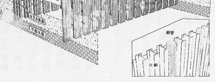
, one of the first HDD projects in Australia.")
5 Coalcliff Landslide - passive drainage well layout Passive drainage wells and manhole wells connected by slotted horizontal pipes. Drainage wells were spaced at 20m, while manhole wells were at 120 m spacing Horizontal pipes installed in 1997 using Horizontal Directional Drilling (HDD), one of the first HDD projects in Australia. Water collected at manhole MHW4 discharged to an outfall. Coalcliff Landslide - passive drainage well details Passive drainage wells were 600 mm in diameter with 450 mm diameter inner pipes Manhole wells were 1200 mm in diameter Wells extended to bedrock at about 20 m depth 5


6 Coalcliff Landslide - drainage well after construction 600 mm diameter passive drainage well with 450 mm diameter pipe 1200 mm diameter manhole well with 900 mm diameter pipe and 200 mm diameter connecting horizontal drain Coalcliff Landslide - recent CCTV inspection Recent CCTV photo of 200 mm horizontal drain at 11 m from Manhole MHW1 Recent CCTV photo of 200 mm horizontal drain at 107 m from Manhole MHW1 6

7 Coalcliff Landslide - pressure head data Piezometer 5A Historical groundwater level monitoring data At 12.7 m depth, clear reduction of hydraulic head from 8 m above ground level to 3.5 m below ground level At m depth, clear reduction of hydraulic head from near ground surface to 9 m below ground level Double Bay Commercial Centre 7


8 Double Bay locality map Double Bay study area Narrow drain valley filled with water charged alluvial sediments Bedrock at 35 m depth maximum and becomes shallow at Eastern, Western and Southern sides A number of commercial and residential developments with basement carparks with partial or full depth cut-off walls Concerned about multiple cut-off walls disrupting groundwater flow and acting as flow barriers 8


9 Double Bay study area modelled basement construction 2 proposed developments in 1998 included basement construction with full depth cut-off walls Jamberoo Lane site was constructed. Assessment concluded that cut-off walls would not cause significant changes in groundwater level. Kiaora Lane site did not proceed due to various reasons, but was subjected to groundwater assessment in Double Bay study area bedrock model Numerical groundwater modelling were conducted Model included variable bedrock level based on various borehole logs drilled in the area 9


10 Double Bay study area modelled basement construction Model included basement construction with full depth cut-off walls Blocking about half of the natural groundwater flow path across the drown valley Double Bay study area modelling results Before construction of full depth cut-off walls With full depth cut-off walls causing mounding and lowering of groundwater level 10


11 Kangaroo Valley Sewerage Scheme Kangaroo Valley Sewerage Scheme Locality map Low Pressure Mains Alignment Water Reclamation Facility Installation of pipelines using Horizontal Directional Drilling technique for construction of sewerage system in
12 Kangaroo Valley pipeline alignment 350 m long pipeline 700 m long pipeline Kangaroo Valley pipeline longitudinal section 12


13 Kangaroo Valley Horizontal Directional Drilling Tokyo Gaikan Expressway, Japan 13
 14")
14 Tokyo Gaikan Expressway, Japan previous experience Project Name Construction Period (Tokyo Outer Ring Road Committee Report, 2002) Tokyo Gaikan Expressway, Japan expressway network Part of Tokyo Outer Ring Road From Matsudo Interchange to Ichikawa Interchange Design completed in Construction commenced in 2009 and completed in early (Sekiguchi and Hozaki, 2003) 14
 Tokyo Gaikan Expressway, Japan cross")
15 Tokyo Gaikan Expressway, Japan schematic section Expressway section - 12 km long Underground section 9.5 km long Construction using cut and cover techniques (Tokyo Outer Ring Road Committee Report, 2002) Tokyo Gaikan Expressway, Japan cross section of tunnel (Sekiguchi and Hozaki, 2003) 15


16 Tokyo Gaikan Expressway, Japan 3 dimensional model (Tokyo Outer Ring Road Committee Report, 2002) Tokyo Gaikan Expressway, Japan 3D view of cut-off walls (Tokyo Outer Ring Road Committee Report, 2002) 16
 (Impermeable material) (Water recharge block) (Water flow block) (Tokyo Outer Ring Road Committee Report,")
17 Tokyo Gaikan Expressway, Japan 3D view of passive drainage system Water recharge block Water catchment block Water flow block (Tokyo Outer Ring Road Committee Report, 2002) Tokyo Gaikan Expressway, Japan details of passive drainage well system (Water catchment block) (Impermeable material) (Water recharge block) (Water flow block) (Tokyo Outer Ring Road Committee Report, 2002) 17
 Tokyo Gaikan Expressway, Japan groundwater variation consideration")

18 Tokyo Gaikan Expressway, Japan numerical modelling Without passive drainage wells With passive drainage wells (Tokyo Outer Ring Road Committee Report, 2002) Tokyo Gaikan Expressway, Japan groundwater variation consideration Groundwater level without treatment Allowable groundwater level Allowable groundwater level Groundwater level without treatment Localised rising and lowering of groundwater level in-between wells (Tokyo Outer Ring Road Committee Report, 2002) 18


")

 19")
19 Tokyo Gaikan Expressway, Japan construction stage (Tokyo Outer Ring Road Committee Report, 2002) Tokyo Gaikan Expressway, Japan construction progress 31/12/ /05/ /02/ /01/2018 (Google Earth Pro) 19

20 Colnbrook Landfill, UK Colnbrook Landfill, UK (Google Earth Pro) Gravel extraction and formation of an inert landfill Alluvium and floodplain gravels over Clay Gravels have a high hydraulic conductivity and form an unconfined aquifer with a relatively shallow groundwater level There was a previous history of groundwater flooding in the area Concerns were raised at planning about the impacts of the inert landfill blocking groundwater flow 20


21 Colnbrook Landfill, UK The site is located between two water supply reservoirs, where the gravel has been removed The direction of groundwater flow is approximately north to south The new landfill may block groundwater flow in the remaining gap between the two reservoirs Another landfill was proposed (by third parties) to the east of the site (Preene 2009) Colnbrook Landfill, UK numerical modelling A 3-dimensional numerical model was constructed using MODFLOW Model included reservoirs, rivers, lakes and ponds The model was calibrated against monitoring data Various impact and mitigation scenarios were modelled (Preene 2009) 21


22 Colnbrook Landfill, UK passive horizontal drain details Mitigation was proposed in the form of a groundwater drain around the site to allow natural flow to bypass the site and avoid groundwater flooding to the north of the site (Preene 2009) Colnbrook Landfill, UK development progress December 2004 December 2010 August 2013 March 2017 (Google Earth Pro) 22
23 23