Use of Space-based Systems for Water Resources Management In India
|
|
|
- Helen Dorsey
- 5 years ago
- Views:
Transcription

1 49 th Session of UN-COPUOS (7-16 June 2006) Agenda Item 12: Space and Water Use of Space-based Systems for Water Resources Management In India Presentation by Dr. K. Radhakrishnan Indian Delegation

2 . we must be second to none in the applications of advanced technologies to the real problems of man and society. Vikram A. Sarabhai ( ) 1971) A Vision (1963)- shared and sustained; realized and enriched

3 The Drivers for Space- based Remote Sensing Applications in India Disaster Management Weather Prediction Water Security Food Security Energy Security Environment Security Smart Governance Sustainable Development

4 2% of World s geographical area 4% of World s Water Resources 17% of World s population Poor predictability of Monsoons Water Resources Management- The National Imperatives 4000 billion cubic metres of rainfall annually, however, only 12% of it is presently being utilized. Predominantly Rain-fed Agriculture, Degraded Lands (57%), Low Irrigation Efficiency (~ 35%) Declining per-capita availability of water ( 5200 cubic metres in 1951 to nearly 1700 cubic metres now) leading to a water stress condition. Over-exploitation exploitation of Ground Water in several areas
 INSAT-2E (1999) INSAT-3A (2003) IRS-1C (1995) IRS-P3 (1996) IRS-1D (1997) OCEANSAT-1 (1999)")
5 A Constellation of state-of of-the-art EO Satellites Imaging Providing Receiving with SpatialS Resolution of 1 km to 1 metre Repetitivity of 22 Days to every 30 minutesm Data in India and several Ground Stations abroad Enabling Mapping from 1:1 1 Million scale to Cadastral Level KALPANA-1 (2002) INSAT-2E (1999) INSAT-3A (2003) IRS-1C (1995) IRS-P3 (1996) IRS-1D (1997) OCEANSAT-1 (1999) CARTOSAT-1 (2005) RESOURCESAT (2003) + Airborne SAR ALTM, Digital Camera

6 Ensured and Sustained Thematic Satellite missions for the near future OCEANSAT-2 CSCAT, OCM RESOURCESAT 2 LISS III 23 m ; 140 km; 4Xs LISS IV m ; 3Xs AWiFS - 60 m; 370 x 2 km CARTOSAT-2 PAN m, 11 km RISAT C-band SAR; m Multi-Pol; Multi mode MEGHATROPIQUES SAPHIR, MADRAS, ScARAB
7 National Natural Resources Management System- A Unique Institutional Arrangement Department of Space (Nodal Department) Academia National Institutes PC NNRMS Chair: Member (Science), Planning Commission Standing Committee on Water Resources (Chair: Secretary, MoWR) Secretaries of Govt. of India Ministries Govt. of India Ministries State Departments State Governments State Remote Sensing Application Centers ISRO, NRSA, National Institutes Academia, R&D Institutions Operations Operations R & D Policy
8 Irrigation Infrastructure Monitoring National Water Resources Information System Flood, Drought, Cyclone Weather Forecasting Inter-basin Transfer Command area Monitoring Surface Water Inventory Space-based Remote Sensing is utilized country-wide, on several facets of Water Resources Management Rainfall Estimation Snow, Glacier Inventory Watershed Development Reservoir Sedimentation Ground Water Targetting

9 Surface Water Inventory About 500,000 water bodies/tanks used for irrigation Storage capacity coming down due to Silting etc. Area under tank irrigation 4.78 Million ha in ; 63; 3.07 Million ha in A National Project for Repair, Renovation and Restoration of Water Bodies launched where space-based remote sensing provides significant inputs

 2007)")
10 Reservoir Sedimentation Annual Sedimentation rate more than 1.5 to 3 times more than designated rate Use of Satellite data to estimate reduction in the Live Storage Region whereas conventional hydrographic surveys used for the Dead Storage Region A National action plan for Sedimentation Assessment of 124 Reservoirs is being implemented during 10 th Plan ( ) 2007) under the NNRMS Standing Committee on Water Resources
11 Command Area Monitoring Irrigation potential created to the tune of 100 Mha.. But Water use efficiency (~ 35%) needs to be improved (to 50%) Periodic performance evaluation of Command Areas being done using Remote Sensing data Centrally sponsored Command Area Development Project and National Water Management Project ongoing; National Water Resources Information System initiated under the NNRMS Standing Committee on Water Resources

12 Inter-basin Transfer 12 major river basins and 46 medium river basins with ultimate irrigation potential of 140 Mha Episodic deficits and excesses; floods and droughts in several parts Feasibility studies underway on interlinking of river basins Space remote sensing inputs used Feasibility studies Topographical Surveys, Hydrological Surveys, Geo-technical / Geological, Environmental & Ecological Command Area Surveys, Base line information, Water balance studies, Run-off estimation in un-gauged basins
; Rural (21%) Exploitation more than 50% in several areas (Red Colour) Space-based remote sensing being used fruitfully to prepare ground water prospects map under a national Mission-Rajiv")
13 Ground Water Targeting Ground Water constitutes 55% of irrigation water requirement, 50% of urban water supplies and 85% of domestic use in rural areas Problems in access to Drinking water: Urban (15%); Rural (21%) Exploitation more than 50% in several areas (Red Colour) Space-based remote sensing being used fruitfully to prepare ground water prospects map under a national Mission-Rajiv Gandhi Drinking Water Mission


14 The Map contains information on: Satellite Image Ground Water Prospects Map Hydrogeomorphological unit Geological Sequence / Rock type Depth to water table &no. of wells observed Recharge conditions Aquifer material Types of suitable wells Depth range of wells Yield range of wells Homogeneity of the aquifer Water Quality Recharge structures

15 National Drinking Water Mission Implementation H.P Rajasthan Gujarat Madhya Pradesh Chattisgarh Jharkhand Orissa Andhra Pradesh Karnataka Kerala So far 2,20,000 wells have been drilled with % success rate and 7500 recharge structures have been planned/ implemented by the line depts in the respective States


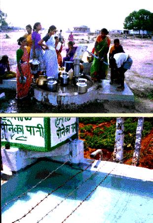
16 National Drinking Water Mission The Impact The Last Mile Before After
17 Watershed Development Judicious management and conservation of soil and water resources on Watershed basis is a prerequisite for sustaining productivity Space-based Remote Sensing played a significant role to prepare Integrated data base on current land use, geomorphology geology, soils, forest cover, socio- economic information required for: Characterisation and Prioritisation of watersheds to be take up for treatment (for decision makers) Generation of action plans locating water harvesting structures, conservation measures, alternate land use (through a participatory process at local community level) Monitoring of the changes and impact

18 Watershed Development Integrated Mission for Sustainable Development ( ) 2000) covered 84 Mha from 25 States [on 1:50,000 Scale using Satellite Data] Land Treatment Plans for rainfed rice, oilseeds, pulses and cotton Integrated resources System for Desertic Areas in 7 States
 Glacier Retreat monitoring using IRS PAN")
 at Bhakra Dam")

19 Snow and Glacier Inventory Snow studies in Sutlej Basin (NOAA Data) Glacier Retreat monitoring using IRS PAN stereo data Seasonal ( April-June) Snow melt run-off forecast ( < 10% error, 1 st week April) at Bhakra Dam in Sutlej basin, being enlarged for other basins. Himalayan Glacier Inventory (>2400 nos.), mass balance & retreat t by RS

20 Irrigation Infrastructure Monitoring Mapping of Canal network, Cross drainage and other irrigation infrastructure using High resolution Satellite data Assessment of Irrigation Potential created vis-à-vis planned Nation-wide monitoring of all ongoing projects using Cartosat data underway, under Accelerated Irrigation Benefits Programme of then Government of India


21 Disaster Management 2005 Tsunami NDEM 2000 Forest Fire Monitoring Landslide Hazard Zonation DSC 1995 Cyclones-Inundation and Damage asssessment Earthquake Damage Assessment National Agricultural Drought Assessment and Monitoring Flood Inundation Mapping and Damage Assessment


22 Flood Disaster Management Space inputs nrsa Historic flood of river Brahmaputra Flood inundation Flood map <-Damaged Road Assessment of damages Marooned villages Villages under inundation during 29 Jun-02 Aug, 199 Receded inundation in Villages by 02 Aug 1999 Flood hazard zones Information derived from Space Flood inundation map Flood damage assessment River Configuration & Flood control works Bank Erosion Flood Hazard Zones River Configuration Utilisation of information Bank Erosion & eroded bunds Organising Relief operations Planning Flood Control Works Identification of chronic Flood prone areas Strengthening of existing Flood Control Works Flood plain zoning
23 RS & GIS Capacity Building Period Students/ Year > Total Trained: 5860 * * ( Mar 2006) Renamed as IIRS M.Tech (AU) M.Sc., (ITC) International Technology & Economic cooperation (MEA) NNRMS Faculty Training 1976 Indian Photo Interpretation Institute Under NRSA 1966 Indian Photo Interpretation Institute Under Survey of India / ITC Aided

24 Thank you for kind attention