Langhope Rig Windfarm Environmental Statement
|
|
|
- Brianna Megan Stanley
- 5 years ago
- Views:
Transcription


1 montage Langhope Rg Wndfarm Envronmental Statement Non Techncal Summary May 006
2
 forms part of the Envronmental Statement (ES) to ac- Lmted, a subsdary company an applcaton by Langhope Rg Wndfarm (Scotland) company")
 has ars- levels of carbon doxde en n response to growng concern about the rse n atmospherc (CO ) and other greenhouse gases,")
 s a major contrbutor to greenhouse gas emssons, and reducng ther use and ncreasng the proporton of power generated from renewable energy sources s seen as a vtal")
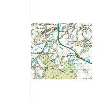
3 ll j ased upon the Ordnance Survey Map w th the perm ss on of the Contro er of Her Ma esty s Stat onery Off ce. Crown Copyr ght. Entec UK Ltd. AL Ste Locaton Ste Locaton ackground Ths Non Techncal Summary (NTS) forms part of the Envronmental Statement (ES) to ac- Lmted, a subsdary company an applcaton by Langhope Rg Wndfarm (Scotland) company of Artrcty Developments (UK) Lmted to construct and operate a 0 turbne wndfarm named Langhope Rg, to the west of Ashkrk n the Scottsh Borders Councl area. Interest n renewable energy producton (such as that produced by a wndfarm) has ars- levels of carbon doxde en n response to growng concern about the rse n atmospherc (CO ) and other greenhouse gases, and the changes n global clmate that ths could be causng. Burnng fossl fuels (coal, ol and gas) s a major contrbutor to greenhouse gas emssons, and reducng ther use and ncreasng the proporton of power generated from renewable energy sources s seen as a vtal part of reducng these emssons. In order to meet nternatonal oblgatons the UK Government and Scottsh Executve are commtted to reducng greenhouse gas emssons n an attempt to reduce the effects of clmate change that the Executve beleves are already beng experenced n Scotland. To ensure that UK and Scottsh targets are met the Renewables Oblgaton (Scotland) has been placed on all electrcty supplers. Ths oblges them to ncrease the proporton of power that they supply from renewable sources, and ncludes a system of targets and f- met. The Scottsh Executve nancal penaltes that wll be mposed f these targets are not expects that much of the new power generaton capacty requred to meet the Renew- n the short term these wll able Oblgaton (Scotland) wll come from wndfarms, and that be prmarly on land rather than offshore. Scotland has one of the wndest clmates n Europe, gvng the country great potental to use ths resource to generate electrcty. The Wndfarm The proposed development s descrbed n detal n the Man Report. A bref descrpton of the proposal s gven below: The proposed development ste boundary ncludng access route occupes a total area of around,500 hectares, though the wndfarm nfrastructure occupes only a small fracton of ths. The wndfarm s located on Belmanshaws, a hll wthn Ettrck Forest located approxmately 0km north west of Hawck and approxmately 0km south west of Selkrk. The ste was selected followng a thorough revew takng account of envronmental senstvtes, plannng polcy and wndfarm locatonal gudance. Ths concluded that the ste was n accordance wth the developer s ste selecton crtera and was poten- tally sutable for wndfarm development. 0 wnd turbnes, wth a maxmum heght to blade tp of.m are proposed. Assocated ancllary development comprsng unt transformers, meteorologcal mast, new and upgraded access tracks, substaton, borrow pts, temporary ste compounds and laydown area, also form part of the applcaton for plannng consent. Vehcular access wll be from the B7 west of Roberton at Alemoor Reservors. The ac- cess route utlses exstng forest tracks along wth new sectons.
4 --- B PP --- ḆB BP BP0000 BP BPPP B - BP BPP BP A B PP BPP000 BPPP BPP000 ased upon the Ordnance Survey Map wth the permsson of the Controller of Her Majesty s Statonery Offce. Crown Copyrght. Entec UK Ltd. AL N 5 BP- C B PP-AA BB BBPPP BBBPPP BBBPPP Envronmental Impact Assessment Envronmental Impact Assessment (EIA) s a process by whch nformaton about the envronmental effects of a project s collected, evaluated, and taken nto account n ts desgn, the decson as to whether t should be gven consent, and f t s gven consent, how t s subsequently to be bult, operated and dsmantled. The developer presents the nformaton on the project and ts envronmental effects n an Envronmental Statement Ste boundary Development ste 8 Access ste 4 Ste Infrastructure Turbne locaton Ste boundary Development ste New ste road Upgraded ste road Permanent mast locatons (ES). Potental borrow pt area Access ste 8 Temporary laydown area 4 Ste Infrastructure 9 Temporary constructon area 3 0 Turbne locaton Ste substaton compound New ste road Proposed access constructon Upgraded ste road compound Permanent mast locatons New watercourse crossng BBP -C C 6 Potental borrow pt area Temporary laydown area Ste boundary Temporary constructon area 5 Development ste 7 Ste substaton compound 8 Access ste Proposed access constructon 4 compound Ste Infrastructure 3 0 Turbne locaton Exstng culvert (to be replaced) New ste road Upgraded ste road Permanent mast locatons BBBPP ḆB -C 9 New watercourse crossng BBP-C Ths product ncludes mappng data lcensed from Ordnance Survey. Crown copyrght and/or database rght 004. Lcense number BP B BPP000 Exstng brdge (to be replaced) BP-AAA --- A Potental borrow pt area Temporary laydown area Temporary constructon area Ste substaton compound Proposed access constructon compound New watercourse crossng Exstng culvert (to be replaced) Exstng brdge (to be replaced) 0 km.5 km Scale A3 Langhope Rg Wndfarm Proposed Envronmental Statement Ste layout Fgure 6. Proposed Ste Layout The wndfarm wll connect nto the electrcty transmsson system from a proposed new onste substaton to an exstng substaton at Hep Hll near Hawck. The grd connecton 4676-E04.wor donoa does not form part of the applcaton for plannng permsson, as t wll be the respons- Scale A3 blty of Scottsh Power. Ordnance Survey. Crown copyrght and/or database rght 004. Lcense number May km.5 km The electrcal output of the proposed wndfarm s antcpated to be 3MW, though the Langhope Rg Wndfarm Envronmental Statement output may vary from ths dependng on the turbnes specfed and procured for the ste through a compettve tenderng process. Fgure 6. Proposed Ste Layout A wndfarm of 3MW s suffcent on average to supply the equvalent of the domestc electrcty needs of approxmately,860 homes. May 006 BB PP-A 4676-E04.wor donoa m Ordnance Survey. Crown copyrght and/or database rght 004. Lcense number The proposed wndfarm s desgned wth an operatonal lfe of 5 years and permsson s sought for ths perod of operaton only. Constructon, ste-restoraton and commssonng of the wndfarm s antcpated to take about 0 months, wth opportuntes for local workforces and companes to be nvolved. Consultaton A key aspect of the Envronmental Impact Assessment s consultaton, both to agree the scope of the document to be submtted and to understand publc percepton of the wndfarm n order to help n the desgn process. Organsatons consulted ncluded The Scottsh Executve, Scottsh Borders Councl, Ettrck and Yarrow Communty Councl, Lllesleaf, Ashkrk and Mdlem Communty Councl, Scottsh Natural Hertage, Royal Socety for the Protecton of Brds, Scottsh Envronment Protecton Agency, Hstorc Scotland and many others. Exstng culvert (to be replaced) Exstng brdge (to be replaced) Publc consultaton was also undertaken and ncluded a publc exhbton, n Ashkrk n December 005 at whch members of the publc were nvted to provde ther vews and comment on the proposals. Envronmental Scale A3 Effects Introducton 0 km.5 km The followng sectons provde a bref summary of the man fndngs of the EIA as set out Langhope Rg Wndfarm Envronmental Statement n the techncal sectons wthn the Man Report. Fgure 6. Proposed Ste Layout Landscape and Vsual The assessment has been completed through a combnaton of desk based revew, May E04.wor feld donoa survey, the use of computer generated mages of the proposed development all n combnaton wth professonal judgement. It has also been nformed by responses from the varous consultaton actvtes undertaken. Landscape Assessment Landscape effects are defned as changes to landscape elements, characterstcs, character, and qualtes of the landscape as a result of development. The proposed development s located wthn an area of large scale landscape wth dentfed capacty for wndfarm development. Specfcally t s wthn the Southern Uplands Type wth Scattered Forest Landscape Type. It s surrounded by hgher rdges on three sdes, whch reduces vsblty greatly to the surroundng areas. Locally, the wndfarm would be surrounded by forestry on two sdes, whch reduces vsual effects of the ancllary equpment, whch have been senstvely desgned to reduce envronmental effects. The land cover s predomnantly composed of undulatng rough grazng and moorland wth some pockets of blanket bog. In terms of landscape value, the local area s not desgnated. The closest landscape desgnatons are The Eldon/ Bowhll Area of Great Landscape Value ~5-6km to the north and the Upper Tweeddale/Tweedsmur Hlls AGLV ~9km to the northwest.

 along wth a resdental assessment whch ncluded consderng the lkely vsual")

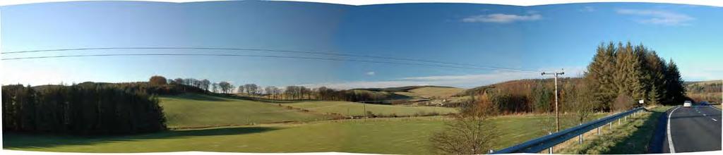
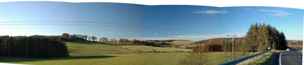
5 The concluson from the assessment s that there are no sgnfcant landscape effects expected from the total development. Vsual Assessment Vsual effects are concerned wholly wth the effects of the development on vews, and general vsual amenty, and also the vsual effects of ths wndfarm n combnaton wth other wndfarm development. Ths Photograph part of of the Exstng assessment Vew was aded by vewpont assessment (whch consdered 8 representatve vewponts) along wth a resdental assessment whch ncluded consderng the lkely vsual effects on propertes wthn ~5km, wth the assessment completed from publc roads and footpaths wthn the area. Sgnfcant vsual effects would occur from three propertes at Wester Essensde settlement, Blaweare and two propertes above Krkhope. There would also be sgnfcant vsual effects from the closest areas around the development wthn the local landscape, whch would nclude local walkers on the undesgnated paths around and through the development. As the land s undulatng, not all of the closest areas wll be sgnfcantly effected just small patches of ground. There would be sgnfcant vsual effects on people fshng at the closest lochs to the west of the ste, Shaws Under Loch through the forestry and Akermoor Loch. There would also theoretcally be a sgnfcant vsual effect f all exstng, under constructon, consented and all submtted wndfarm applcatons were consented, bult and seen from partcular parts of the Scottsh Borders at the same tme. Summary The ste shows desgn ratonale as t Wreframe s stuated close to energy users ncludng some man towns, although n a relatvely sparsely populated secton of land. The vsblty (as llus- 3 trated n the ZVI) s lmted due to the ste s hgher surroundng topography. The majorty of the resdental receptors n the adjacent areas are stuated along the valley floors and wll receve mnmal to no vews. The wndfarm s not proposed to be bult n an area desgnated for ts scenc qualty and the area s dentfed as havng capacty for wndfarm development. Ths 0 turbne wndfarm has been subject to detaled desgn to ensure a smple composton s vewed from the mportant, hgh senstvty or well vsted vewponts. Ths development s therefore consdered to be able to be accommodated wthn ths large scale rollng landscape. 0 km Scale :50,000@ A3 3 km Nose Constructon Nose Durng the constructon perod a range of dfferent actvtes would take place ncludng the extracton of stone for use n roads, the constructon and upgrade of access tracks, the erecton of turbnes and other nfrastructure along wth ste restoraton. Constructon nose wll be lmted by restrctng workng hours. The assessment concludes that whle constructon nose may be perceptble at the closest houses, wth mtgaton and gven the dstances between the houses and the expected constructon actvtes, any constructon nose wll be wthn recognsed lmts and wll not be sgnfcant. It s assumed that decommssonng nose wll be generally less, or at worst realstc case, smlar to that experenced durng the constructon perod. Operaton Nose Careful attenton to the number and layout of turbnes has establshed a scheme that meets proposed nose lmts at the closest propertes, based on establshed methodologes. The manufacturer of the turbne selected for ths ste wll be contractually requred to guarantee nose emsson levels from turbnes nstalled on the ste. The operator of the wndfarm ste wll be requred to comply wth the nose crteron levels that have been establshed for ths ste by condton attached to the grant of any development consent. Ecology and Nature Conservaton The work to understand what effects the proposed wndfarm would have on anmals and plant communtes on the ste was agreed wth organsatons who have an nterest n the subject and nvolved a desk study to gather exstng nformaton about the ste and survey work to understand what anmals used and plants colonsed the ste The area on whch the proposed development wll be sted generally comprses degraded habtats, shown by the types of plants on the ste, though the man access track s through forestry and along upgraded exstng tracks. The most mportant habtats on ste are heath and bog habtats, whch are consdered to be of mportance at a UK level, although both the habtats are degraded by grazng and dranage. The basn mres, a partcular type of bog habtat, support the best qualty vegetaton on ste and for ths reason the desgn of the wnd farm has avoded these areas. Potentally negatve effects on habtats by the wndfarm relate to the removal and dsturbance of small areas of habtat on ste. Photomontage Photomontage of Proposed Langhope Rg Wndfarm from Wester Alemoor Photomontage produced for llustratve purposes only
6 Computer Generated Wreframe of Proposed Langhope Rg Wndfarm from laweare Wreframe produced for llustratve purposes only The ste supports a number of specally protected speces ncludng badger, salmon and otter. Badger are of lttle mportance n terms of nature conservaton due to ther large populaton, whlst both otter and salmon are of nternatonal mportance due to ther ncluson on the Rver Tweed SAC desgnaton. The desgn of the proposed development and proposed mtgaton measures, coupled wth an ntenton by the developer to do surveys for partcularly mportant speces pror to constructon (for example to ensure any newly establshed badger setts are detected and sutable mtgaton, f requred, s put n place), affords approprate protecton from the development. Desgn of Typcal Wnd Turbne Wth the mtgaton proposed, no sgnfcant adverse effects are lkely on protected speces, and t should be possble to comply fully wth wldlfe protecton legslaton. It s ntended to prepare a habtat management plan that wll enhance the habtats on ste and lead to a greater dversty of plants and anmals on the ste. rds The work to understand what effects the proposed wndfarm would have on brds was agreed wth organsatons who have an nterest n the subject and nvolved a desk study to gather exstng nformaton about the ste and extensve survey work (ncludng establshng nestng and flght actvty) to understand how brds use t. Langhope Rg supports a typcal brd communty of upland margnal farmland and moor. Because there s an extensve area of conferous forest, managed grouse moor and a seres of lochs near the ste, the dversty of brds recorded durng survey work was relatvely hgh, although common speces accounted for the vast majorty of observatons. The brd of greatest conservaton nterest makng regular use of Akermoor Loch and Shaw s Under Loch was osprey durng sprng and autumn when t s mgratng. Other features of the brd communty are black grouse and goshawk. Nether speces was recorded makng extensve use of the ste. Collson rsk modellng has ndcated that several speces: pnk-footed goose, barnacle goose, golden plover, osprey, goshawk and peregrne, are at rsk of collson wthn the projected lfe of the wndfarm. However, the potental effect of ths on the populatons of both pnk-footed and barnacle geese wll not be sgnfcant. Addtonally, the best avalable nformaton ndcates that wldfowl avodance rates at wndfarms are far hgher than the 95% avodance rate ncorporated nto the collson rsk model and, as such, the theoretcal collson rate s lkely to be a consderable overestmate. Dsplacement of osprey or goshawk s consdered unlkely to occur, and even f t dd there are extensve areas n the mmedate vcnty wth the types of habtats whch sut them for foragng and nestng thus no sgnfcant effect s consdered lkely. Peregrne numbers are generally lmted by the avalablty of nest stes rather than the avalablty of foragng habtat. There are no nest stes for peregrne on ste and gven relatvely low level of foragng actvty recorded no sgnfcant effect s consdered lkely. Traffc and Transport The man transportaton mpacts wll be assocated wth the movements of commercal Heavy Goods Vehcles (HGVs) to and from the ste durng the constructon phase of the development. Survey data from 005 was obtaned from Scottsh Borders Councl for the B7 n Rober-


7 k Photomontage of Proposed Langhope Rg Wndfarm from laweare Development ste wth turbnes Landscape and vsual study area 0km radus ndcator from wndfarm centre 0km radus ndcator from wndfarm centre 30km radus ndcator from wndfarm centre Photomontage vewpont locaton Photomontage produced for llustratve purposes only Wreframe vewpont locaton Cumulatve vewpont locaton ton and the A7 n Hawck. The data then had a growth factor appled to adjust t to the son and Wester -3 turbnes Burns may be vsble whch flow nto Alemoor Reservor. The current surface water dranexpected values n the year of assessment, turbnes may be vsble ng from the ste to these rvers s classfed by the Scottsh Envronment Protecton Agency 7-0 turbnes may be vsble 0 as of good qualty and the rvers support salmon populatons. Vewpont constructon of the wndfarm s predct- The maxmum traffc mpact assocated wth the. Wester Essensde. Blawere 9 ed to occur n the fourth month of the constructon programme. Durng ths month, an 3. Outer Huntly 4. Wester Alemore Two 5. Above Ettrckbrdge 6. A7, South of Ashkrk have been dentfed, Langhope Farm and Todrg Farm, whch prvate water supples 5 average of 8 two-way HGV trps and 30 two-way lght vehcle trps are predcted to be 7. Glmanscleuch - Inch 8. Hep Hll 9. Selkrk Golf Course 0. Three Brethren have catchments. Bonchester Brdge. Eldons that could potentally be affected by the proposed development. 3 generated on each workng day, whch equates to 7 an ncrease 6 of 3% for HGVs and % 3. Scott s Vew 4. Carters Bar However the proposed turbne locatons are located such that they are not expected to for lght vehcles on the Vewpont B7. A detaled parameters: assessment of effects on the B7, was therefore nfluence Cumulatve the Vewpont contnuaton of ther supply. Langhope Rg Wndfarm. Broomy Law. Eldons 3. Scott s Vew 4. Carters Bar cated on a mnor undertaken road near n accordance wth best practce. 4 8 Envronmental Statement west towards the ste. Grd reference: E , N Angle of vew: The assessment has hghlghted 90 a number of potental mpacts on the water envron- 0km Turbne Parameters: the wndfarm s All llustrated potental n the effects are consdered to be able to be accommodated because of the ment, prmarly durng wndfarm constructon, but potentally also durng Elevaton: 30 AOD Vewng The ZVI s based on the followng turbne 4.8cm Fgure 7.3 dmensons: short term nature of any dsturbance and are not sgnfcant. Any dsturbance caused ste operaton and decommssonng. These mpacts are assocated 4 Dstance to nearest vsble turbne: 9@4,98m Number 4 of hubs vsble Hub heght: 80m 0 Vewpont No : Blaweare Development ste wth turbnes m ths vewpont s llustrated at Rotor dameter: 8.4m by constructon traffc could be further lmted through the mplementaton of a Traffc Blade tp:.m Dstance to nearest turbne: 9@4,98m Number of blade tps vsble 0 Landscape and vsual study area Management Plan. May E05a.cdr 0km radus ndcator nelsm from Archaeology and the Hstorc ult Envronment (Cultural Hertage) The work to understand what effects the proposed development would have on Cultural Hertage was agreed wth organsatons who have an nterest 30km n the subject and nvolved a desk study to gather exstng nformaton and survey work to fnd archaeologcal stes. Twenty-one archaeologcal stes have been dentfed wthn the area of the wndfarm development ste. No stes were dentfed wthn a 00m corrdor centred on the proposed access route. Reproduced The from Ordnance development Survey dgtal map data Crown copyrght 004. All was rghts reserved. desgned Lcence number to avod developng on all but two of the stes. A trackway and area of Rg and Furrow are unavodably crossed by access tracks for the development. The assessment concludes that wth approprate nvestgaton durng constructon such effects would not be sgnfcant and that none of the stes dentfed would receve a sgnfcant mpact from development. The potental of proposed turbne locatons to contan bured and undentfed remans of archaeologcal sgnfcance s assessed as low to mperceptble. the Controller of Her Majesty s Statonery Offce. Crown Copyrght. Entec UK Ltd. AL A study was also undertaken to establsh what effect the wndfarm would have on the settng of more dstant cultural hertage features. Fourteen cultural hertage receptors present wthn 0km of the turbnes would have full or partal vews of the turbnes as constructed, based upon a computer model. In no case would the effect of the presence of 0km 0 km 5 km 0 km 5 km wndfarm centre Scale A3 Dev 0km radus ndcator from The am of ths photomontage s to provde a realstc representaton of the proposed development, however t s for llustratve purposes only. wndfarm It s based centre on current phot Land ased upon the Ordnance Survey Map wth the permsson of the Controller of Her Majesty s Statonery Offce. Crown Copyrght. Entec UK Ltd. AL km wnd 7-0. Wester Essensde 7. Glmanscleuch - In 9. Selkrk Golf Cours The ZVI s based 30km radus ndcator from wndfarm centre Langhope Rg Wndfarm 0km Photomontage vewpont locaton Envronmental Statement wnd Wreframe vewpont locaton Fgure 7. 30km ZVI to Blade Tp wth vewponts Cumulatve vewpont locaton wnd -3 turbnes may be vsble Phot 4-6 turbnes may be vsble Wre 3 3 Cum 7-0 turbnes may be vsble May 006 t 4676-E005a.cdr nelsm 0-3 Vewpont. Wester Essensde. Blawere 4-6 t 3 3. Outer Huntly 4. Wester Alemore 3 5. Above Ettrckbrdge 6. A7, South of Ashkrk 9 7. Glmanscleuch - Inch 8. Hep Hll Selkrk Golf Course 0. Three Brethren Vewpont. Bonchester Brdge. Eldons 3. Scott s Vew 4. Carters Bar 3 3. Outer Huntly Above Ettrckbrdg 9 5 Cumulatve Vewpont. Bonchester Brdg. Broomy Law. Eldons 3. Scott s Vew 3 3. Scott s Vew 4. Carters Bar km Cumulatve Vewpo Turbne Parameters:. Broomy Law 3. Scott s Vew The ZVI s based on the followng 4 8 turbne dmensons: 4 4 Hub heght: 80m 0km Rotor dameter: 8.4m Turbne Parame Blade tp:.m dmensons: 0km km 5 km 0 km 5 km Hub heght: Scale A3 Rotor dameter: Blade tp: the proposed wndfarm upon ts settng be sgnfcant because of the nature and scale 0km 0 km 5 of the vew to the wndfarm ste. Langhope Rg Wndfarm It s consdered that, n overall terms, the effect of the development on the cultural hertage resource, ndvdually and collectvely, would not be sgnfcant. 30km Envronmental Statement Fgure 7. ZVI to Blade Tp wth vewponts Langhope Rg Envronmental May 006 The Water Envronment 4676-E005a.cdr nelsm Reproduced from Ordnance Survey dgtal map data Crown copyrght 004. All rghts reserved. Lcence number The proposed Langhope Rg wndfarm would be developed wthn the ranfall catchment May 0 of three trbutares of the Ale Water, the Langhope Burn, the Blndhaugh Burn and the Wl E005a Reproduced from Ordnance Survey dgtal map data Crown copyrght 004. All rghts reserved. Lcence number km ZVI to lade Tp Fgure 7. ZVI to Blade T
8 6 wth a range of actvtes, ncludng access track constructon and wnd turbne erecton. Most mpacts are assocated wth sedment-laden water runnng from ground exposed to the constructon workngs to watercourses. The mpact assessment has taken account of all hydrologcal features. Hgh rsk buffer zones (.e. proxmty to water courses) have been dentfed as development constrants and the locaton of development nfrastructure has avoded these areas except at watercourse crossngs. Mtgaton measures have been proposed to reduce the lkelhood of a polluton event resultng from the development based on constructon best practce. These mtgaton measures have been defned for all stages of the development and for each onste development (.e. track, turbne, substaton, borrowpt). Measures, n addton to the avodance of hgh rsk areas, nclude use of exstng upgraded access tracks and avodance of the constructon of new culverts through the development ste where possble, as well as response measures n case of accdental fuel spllages and the use of sulphate resstant concrete amongst other measures. The employment of mtgaton measures, n accordance wth current best practce, wll ensure that any negatve resdual effect that does occur s of mnor sgnfcance and quckly controlled. Effects on People and usness The development consttutes a large nvestment n the area by the developer and as such provdes the opportuntes for ndrect postve economc nvestment. Whlst some local resdents may currently have reservatons about the proposed development, prevous surveys at operatonal wndfarms show that these fears may not be fully realsed when the development becomes operatonal. Overall the wndfarm s antcpated to have a neutral effect on resdents perceptons wthn the area. Vstors perceptons of the area are unlkely to change as the wndfarm wll be mperceptble from the man tourst facltes n the area. Survey fndngs show that most vstors are broadly neutral to the concept of wndfarms and ther vews of an area are unlkely to change as a result of seeng one. Overall t s perceved that the proposed wndfarm wll have a postve mpact on socoeconomc effects. Exstng Infrastructure, Telecommuncatons, Televson, Avaton Safety, Shadow Flcker and Other Consderatons Consultatons wth provders of nfrastruture and telecommuncatons servces were undertaken and alteratons to scheme desgn made to accomodate those provders exstng servces. The wndfarm s not antcpated to have any sgnfcant effects n respect of exstng nfrastructure, telecommuncatons, televson, avaton safety, shadow flcker and other consderatons. Conclusons The development of a 0 turbne wndfarm at Langhope Rg wll contrbute to both the UK government s target of reducng CO emssons and the Scottsh Executve s target of generatng energy from renewable sources. The Envronmental Impact Assessment of the proposed Langhope Rg Wndfarm has addressed a wde range of potental mpacts on dfferent aspects of the envronment. The emergng fndngs of the assessment process have had a major part n the desgn of the wndfarm and pckng the fnal ste layout. A range of other measures are proposed wthn constructon and operatonal practces to address the potental envronmental effects. The wndfarms major postve effect s ts broader contrbuton to reducng greenhouse gas emssons n a sustanable way. For further nformaton: Coln Palmer Entec UK Lmted, 9A Unon Street 6/7 Newton Terrace, Greenock Glasgow, PA6 8DD G3 7PJ Tel: / Fax: Tel: emal: coln.palmer@artrcty.com webste: