Ewe Hill Windfarm. Non-Technical Summary
|
|
|
- Juniper Andrews
- 5 years ago
- Views:
Transcription

1 Ewe Hill Windfarm Non-Technical Summary October 2009
2 Contents 1. Introduction Environmental Impact Assessment Windfarm Proposal Legal and Policy Framework Landscape and Visual Ecology Ornithology Hydrology, Hydrogeology and Hydrogeology Cultural Heritage Noise Access, Traffic and Transport Land Use, Socio-Economics and Recreation Other Considerations Conclusions Non-Technical Summary RPS Planning & Development
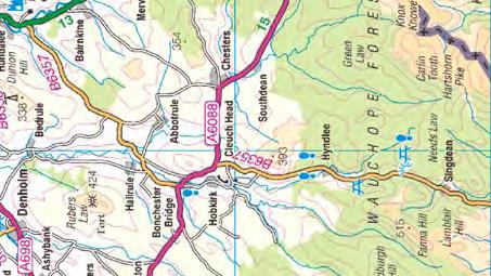
3 1. Introduction 1. This Non-Technical Summary (NTS) summarises the Environmental Statement (ES) which accompanies a Planning Application to Dumfries and Galloway Council under the Town and Country Planning (Scotland) Act 1997 (as amended by The Planning etc (Scotland) Act 2006) for the construction and operation of a six turbine windfarm at Ewe Hill (hereafter referred to as the proposed Development) between Lockerbie and Langholm in Dumfries and Galloway. 2. A previous application for 40 turbines on the Ewe Hill site was submitted in 2004 under Section 36 of the Electricity Act This was reduced to 22 turbines at the request of the Ministry of Defence (MOD), due to potential effects on low flying aircraft. In 2005 an addendum to the original ES was produced, which assessed the 22 turbine scheme and revised layout (hereafter referred to as the Section 36 Application). Dumfries and Galloway Council resolved not to object to the 22 turbine scheme at Committee in February 2006, and confirmed this to the Scottish Ministers. This Section 36 Application is currently awaiting determination by the Scottish Ministers. 3. ScottishPower Renewables has become aware that it may be possible to develop six of the above 22 turbines as an early phase, ahead of a determination on the overall scheme by the Scottish Ministers. The proposed Development consists of the six southern most turbines in the Section 36 Application (albeit in slightly revised positions). 4. The proposed Development comprises 6 wind turbines and ancillary development which will have an installed capacity of up to 18MW. The site area is approximately 819 hectares, of which it is estimated that the land-take of the windfarm and associated features and infrastructure will be approximately 5.7ha, with an additional 3.3ha temporarily required during the construction period. 5. The proposed Development is located between Lockerbie and Langholm, with the B7068 running along the south-western boundary, as shown on NTS Figure Environmental Impact Assessment (Site Selection, Scoping and EIA Approach) Environmental Impact Assessment 6. The EC Directive (85/337/EEC) on the environmental assessment of certain public and private projects was adopted by the Council of Ministers in July In the UK the Directive was initially given legal effect through the Town and Country Planning (Assessment of Environmental Effects) Regulations 1988 (SI No. 1199) which came into force in July In Scotland, these have been replaced by the Environmental Impact Assessment (Scotland) Regulations 1999, which cover developments requiring decisions under the Town and Country Planning (Scotland) Act Guidance on the assessment procedures is provided in best practice guidance relevant to each discipline, and these documents are identified within the relevant chapters of the ES. General guidance used includes: Circular 8/2007 The Environmental Impact Assessment (Scotland) Regulations 1999 (Scottish Executive, 2007), PAN 58 Environmental Impact Assessment (Scottish Executive, 1999), A Non-Technical Summary 1 RPS Planning & Development
4 Handbook on Environmental Impact Assessment (SNH, 2005) and Guidelines for Environmental Impact Assessment (IEMA, 2005). 8. Environmental effects have been assessed, to identify any effects that may be significant in the context of the EIA Regulations. Mitigation is proposed where possible to prevent significant effects. 9. In accordance with the EIA Regulations, the assessment has considered cumulative impacts. By definition these are effects that result from incremental changes caused by past, present or reasonably foreseeable actions together with the proposed Development. Site Selection 10. ScottishPower Renewables internal site selection process is designed to identify potential windfarm sites that are economical, technically viable, environmentally acceptable, most likely to obtain planning approval, and make meaningful contributions to Scotland s targets for renewable energy generation. 11. ScottishPower Renewables site selection policy is outlined in ScottishPower Windfarm Sustainable Development Policy (2006). This policy sets out ScottishPower Renewables policy for all stages of windfarm development, from site selection to decommissioning. Friends of the Earth Scotland, RSPB Scotland, Scottish Natural Heritage (SNH) and WWF Scotland have been consulted on this document. 12. ScottishPower Renewables windfarm site search is an ongoing process, whereby a list of candidate sites is maintained and updated as new opportunities are identified and sites move into development. ScottishPower Renewables conducted four phases of site search exercises in 2000, 2002, 2003, and 2005 which culminated in scrutiny of approximately 400 sites and the short-listing of sites for development. 13. The proposed Development site was shortlisted for development due to a number of factors, including the following: good wind resource; good access to site; lack of statutory nature conservation designations on the site; proximity to a potential grid connection point; relatively sparsely populated; good landscape fit; and location in which a development can accord with the principles set out in SPP6: Renewable Energy. 14. Following internal assessment and confirmation that the site would be taken forward for development, ScottishPower Renewables has engaged in a comprehensive consultation exercise. Details of the scoping and consultation undertaken for the proposed Development are presented below. Scoping and Consultation 15. Scoping is undertaken at the outset of the assessment process according to the guidance provided in Planning Advice Note (PAN) 58: Environmental Impact Assessment (Scottish Executive, 1999). A Request for a Scoping Opinion was also submitted by ScottishPower Renewables to Dumfries and Galloway Council in Non-Technical Summary 2 RPS Planning & Development
5 December ScottishPower Renewables provided an outline description of the proposed Development, the site location and proposed technical assessments. 16. The request for a Scoping Opinion was also used to form the basis for early consultation with a number of organisations. Consultees were asked for relevant information, opinions on the scheme and views on the proposed assessment methodologies. 17. Consultation was undertaken for the Section 36 Application in and also for the proposed Development in where required. This included consultation with a wide and diverse range of organisations including all relevant statutory and public bodies such as Dumfries and Galloway Council, Community Councils, Scottish Natural Heritage (SNH) and the Scottish Environment Protection Agency (SEPA). A full list of consultees is included in the Environmental Statement. 18. Following submission of the Request for a Scoping Opinion, specific consultees relevant to the various assessment disciplines were consulted by the environmental consultants RPS to agree the approach and methods proposed to undertake the individual assessments, including the survey area, survey timings as well as the preferred method of presenting information. Further details are included in Chapters 5-13 within the ES. 19. Public consultation is seen as a key element of the environmental assessment process; therefore as part of the wider consultation process, attention was given to community engagement in cognisance with PAN 81: Community Engagement Planning with People. Local Community Councils were contacted during development of the proposal. 20. A Public Information Day was held on 2 of September 2009, at Tundergarth Parish Hall in Bankshill to provide information regarding the proposed Development to local residents. The information available included plans of the proposed layout, information boards explaining the key potential environmental effects, and photomontages to illustrate anticipated views. Representatives of RPS, Land Use Consultants and ScottishPower Renewables were also available to provide additional information and answer queries. A laptop equipped with Windfarm software was also available, allowing members of the public to see likely views from requested locations (using bare ground wirelines refer to Chapter 5 Landscape and Visual) EIA Approach 21. The general approach to assessing the environmental effects of proposals is to consider the baseline conditions at and around the site for each issue, then to identify the impact of the proposals on the baseline. Where there are international, national and or local standards, policies or guidelines, these are taken into account in the assessment of the significance of the identified effects. 22. The significance of effect was established by determining the sensitivity of a receptor to change in environmental conditions and the magnitude of the predicted change. This process was iterative, in that it considered mitigation that would be incorporated into the site layout design in determining the final assessment of significance. 23. Following the identification of any relevant mitigation measures, the remaining effects, for each of the environmental issues, termed residual effects are summarised at the end of each of the ES chapters. The assessment results are summarised in the following sections. Non-Technical Summary 3 RPS Planning & Development
6 3. Windfarm Proposal 24. The layout of the proposed Development is shown on Figure NTS Figure 2. The operational windfarm will include the following key components: six wind turbines; hardstanding area at each turbine base; on site access tracks and water crossings; substation compound including substation buildings; one meteorological mast (permanent for the duration of the proposed Development operation); and on-site cabling. 25. In addition to the above components of the operational windfarm, the construction phase will also include: two temporary construction compound/laydown areas; two temporary meteorological masts; and four borrow pits. 4. Legal and Policy Framework 26. The UK Government has placed a Renewables Obligation on all UK electricity suppliers to provide 10% of their electricity from new sources by 2010 and 15% by In addition, the Scottish Government has set a target for the supply of 50% of Scotland s electricity from renewable sources by 2020, recognising the extent of Scotland s important renewables resource. 27. Relevant national planning policies, Development Plan policies and other material considerations that are relevant to the determination of the proposed Development have been assessed. Chapter 4 of the ES Legal and Policy Framework, lists the relevant planning policies, whilst an assessment of the proposed Development against these policies is provided separately, within the Planning Statement which accompanies this planning application. 28. SPP6 is of particular relevance to the proposed Development, as it relates to renewable energy. SPP6 highlights Scottish Government s commitment to increasing the amount of electricity generated from clean and sustainable renewable energy sources, as a vital part of the response to global imperatives to tackle climate change and the need to ensure secure and diverse energy supplies. The target for 2010 has been met, so the intention of SPP6 is to facilitate successful achievement of the 2020 target and beyond. The Scottish Government s policy is that whist the 2020 target should be met by a range of renewable technologies, hydro and onshore wind power are currently making the most significant contribution to the 2020 target, and this is expected to continue. SPP6 requires planning authorities to use the Development Plan process to support and encourage the continued growth of all renewable technologies, regardless of scale, whilst ensuring that an area s renewable energy potential is realised in a way that is compatible with other Development Plan policies and objectives. 29. Sections 25 and 37 (2) of the Town and Country Planning (Scotland) Act 1997 (as amended by The Planning etc (Scotland) Act 2006), require that planning decisions Non-Technical Summary 4 RPS Planning & Development
7 be made in accordance with the Development Plan, unless material considerations indicate otherwise. 30. The Development Plan in this instance comprises the Dumfries and Galloway Structure Plan 1999 and the Annandale and Eskdale Local Plan Dumfries and Galloway Council is at the preliminary stages of preparing a new Local Development Plan (LDP) which will replace the current Structure Plan and four Local Plans. Initial comments have been invited, as well as the opportunity to submit details of potential development sites to be considered for inclusion in the new LDP. The Proposed Plan is to be published in July 2011 and following other statutory processes it is expected that the Plan will be adopted in May Landscape and Visual 32. The landscape and visual assessment has considered the effect that the proposed Development will have on the landscape and the people who view that landscape. Based on consultations with Dumfries and Galloway Council, Scottish Natural Heritage, Carlisle City Council and Cumbria County Council, ten viewpoints were selected for detailed assessment. The assessment involved a desk study, field survey and computer modelling. The assessment took account of the presence of four existing windfarms in the study area, Craig (formerly Carlesgill), Dalswinton, Minsca and Great Orton windfarms as part of the baseline condition. 33. The site is not covered by any national, regional or local landscape policy designations. However, the proposed Development will be visible from several designated landscapes across the 35km study area. These include the Nith Estuary NSA, Langholm Regional Scenic Area (which is 4km from the site) and other Regional designations, Gardens and Designed Landscapes and Hadrian s Wall World Heritage Site in Cumbria. The assessment concluded that there would be no significant effects on these designated areas. 34. No significant residual effects were identified for construction activities. In terms of operational effects on landscape character, the assessment has identified that there will be a major effect on the landscape character of the site itself. This is because it will become identifiable as a developed energy-generating site comprising wind turbines, access tracks and a substation which are not characteristic of the existing landscape. The assessment considered effects on landscape character types as identified in the Dumfries and Galloway Landscape Character Assessment and the Cumbria Landscape Classification. The assessment identified a localised moderate effect on the character of the Foothills and Southern Uplands landscape character types that cover the site. However the effect on these landscape character types as whole, given they are much more extensive in the wider landscape was identified as not significant, and the overall change to the landscape character of the surrounding landscape types was judged also to be not significant. 35. The visual effect of the windfarm was assessed in detail from ten agreed viewpoints. Three viewpoints were judged to have moderate visual effects (VP5, Castle O er Fort, VP 8, B722, West Linnbridgeford, VP 17, Corrie Common). The remaining seven viewpoints were judged to have minor or negligible effects. Significant effects were identified for four routes: the right of way which crosses the site (major); and the National Cycle By-Way and two Candidate Core Paths near the site (moderate). No significant effects were identified for settlements across the study area. Non-Technical Summary 5 RPS Planning & Development
8 36. A cumulative assessment was also undertaken which considered the additional effect of introducing the turbines at the proposed Development site, taking into account both existing and other proposed windfarms. No cumulative effects were predicted to affect the landscape, landscape designations or views from static viewpoints, settlements or routes across the study area. This is largely due to the position of the proposed windfarm in the context of the adjacent Section 36 Application, and within a group of local windfarms, including the operational Minsca and Craig schemes, and the Solwaybank proposal. 6. Ecology 37. An assessment was undertaken of the potential for the proposed Development to adversely affect the identified Valued Ecological Receptors (VERs) on the site. 38. The assessment process involved baseline studies, evaluation of the importance of the ecological receptors based on relevant legislation and guidance, and a prediction of the effects on these receptors.the assessment included habitats, plants, mammals, and amphibians. 39. Data on the important wildlife on site and within the study area was obtained through a combination of scoping and desk study to collate existing information, and was further supplemented and verified via field surveys in The baseline surveys undertaken to inform this assessment were the following: Phase 1 Habitat Survey; Bat Surveys (scoping, assessment of roost potential and foraging activity); Otter Survey; Water Vole Survey; Badger Survey; and Electro-fishing survey. 41. No nationally rare or scarce plan species were found in the habitat surveys. Twelve habitat types were identified in the Phase 1 habitat survey, comprising mostly of modified habitats typical of the farmed landscape in the Southern Uplands. 42. Habitats of the proposed Development area are mainly wet modified bog and marshy grassland. The access track passes through marshy grassland, acid grassland and improved grassland, avoiding all areas of blanket bog. Consequently, no blanket bog habitat is lost to the proposed Development. The loss of circa 4.45ha of the unimproved and semi-improved acid grassland is not considered significant, as upland grassland is both more locally extensive and under less threat than lowland acid grassland. 43. No impacts are predicted on bats from either the construction or operational phases of the proposed Development based on current data (with limited activity found only around the building at Carinknowe which will not be directly affected by the proposed Development). 44. No otter resting up sites will be disturbed by the construction of the proposed Development. Otters use the site for foraging or commuting. The species is dependent on clean watercourses and the effects of the development on this species are therefore closely linked to the effects on watercourses. The pollution prevention Non-Technical Summary 6 RPS Planning & Development
9 measures that will be incorporated into the Environmental Management Plan will safeguard this habitat throughout the construction period. 45. Salmon and trout are sensitive to increases in sediment or changes to the quality of watercourses. With the careful site management practices proposed no significant effects are anticipated. Specific measures will include incorporation of pollution prevention measures into the Environmental Management Plan and the use of suitably sized piped watercrossings to allow fish passage where the access roads cross watercourses. 46. The mitigation measures are expected to reduce residual effects to minor or negligible significance, with no long-term negative impacts on any species or habitats of importance as a result of the proposed Development. The potential effects on ecology arsing from the proposed Development have been assessed as not significant in terms of the EIA Regulations. 7. Ornithology 47. An assessment of potential effects of the proposed Development on birds was undertaken. 48. The proposed Development area supports few nesting areas of birds which were classed as high or moderate conservation importance, with curlew being the most common species within these classes (five pairs within the survey area). Several species use the area as a foraging site, but in no case was this use frequent. The proposed Development area does not appear to be located on a regularly used migration route or corridor used for local movements by wildfowl or waders. 49. The significance of the potential effects of the proposed Development on birds was determined by considering the nature conservation importance of each species and the potential magnitude of each effect. In making judgements on significance, consideration was given to the status of, and trends within, national and regional populations. 50. Disturbance of birds and their habitats during construction and decommissioning of the proposed Development is predicted to have negligible short-term adverse effects on existing bird populations. Disturbance of birds due to the operation of the proposed Development, and the risk of collision with rotating rotor blades, are predicted to have negligible long-term adverse effects on existing bird populations. 51. Overall, it is concluded that construction and operation of the proposed Development would not have a significant effect on birds. 8. Hydrology, Hydrogeology and Hydrogeology 52. An assessment was undertaken of the potential hydrological, hydrogeological and geological effects associated with all stages of the proposed Development (construction, operation and decommissioning). This included potential secondary ecological effects on habitats, such as peat or species, and a Peat Slide Risk Assessment in accordance with Scottish Government Recommended methodologies. Non-Technical Summary 7 RPS Planning & Development
10 Surface Water Quality and Flood Risk 53. The proposed Development site lies within the watershed of the Water of Milk and Kirtle Water. The Water of Milk is a tributory of the River Annan, and both the River Annan and Kirtle Water river systems discharge into the Solway Firth SAC. The watercourses within or adjacent to the site boundary which could potentially be effected by the proposed development are the Capel Burn, Cheese Burn, Coom Burn, Papert Sike, Grovegill Burn, Priestsbutts Burn, Winterhope Burn, Kirk Burn and the Kirtle Water. A hydrological and morphological survey of these watercourses has been undertaken. 54. Following the successful implementation of the pollution prevention measures within the Environmental Management Plan, the construction and operation effects of the proposed Development on the quality of the surface water environment is considered to be not significant. Flood risk was also considered with a conclusion that the increased land-take as a result of the proposed Development would have not have a significant effect on flood risk. Peat Slide Risk Assessment 55. Following the implementation of mitigation measures the impacts of the proposed Development on the site soils and peat are considered to be not significant. Given the dominance of shallow peat in the areas of infrastructure it is considered unlikely that the construction activities of the proposed Development would have an effect on the likelihood of peat failure. It is considered that any changes in the baseline peat slide risk as a result of construction activities will be negligible. Geology and Hydrogeology 56. The assessment has determined that there are no designated sites of geological importance within the proposed Development site boundary. The construction of the windfarm will result in permanent alterations to the site geology. It has been concluded that the effects of the proposed Development on the site geology will be not significant. 57. Despite the low productivity of the underlying aquifer units, the hydrogeology was considered to be particularly sensitive due to the bedrock aquifers being dominated by fracture flow. Fracture flow dominated aquifers are more susceptible to pollution as they offer very little attenuation of pollutants. 58. Following the identification and assessment of the sensitivity of the hydrogeology a comprehensive suite of mitigation measures has been incorporated into the design of the proposed Development. In addition, the pollution prevention measures in the Environmental Management Plan and specific mitigation techniques for the construction, operation and decommissioning phases will be implemented to protect the groundwater from pollution. 59. Following the implementation of mitigation measures the assessment has determined that the effects on the site hydrogeology are considered to be not significant. 60. Potential effects on both private and public water supplies were also considered in the assessment, which determined that no significant effects are predicted. 61. A programme of surface and groundwater monitoring will be implemented, including liaison with an Ecological Advisor and SEPA as required. Non-Technical Summary 8 RPS Planning & Development
11 62. Overall, the effects of the proposed Development on the site hydrological, hydrogeological and geological regime are not significant under the terms of the Environmental Impact Assessment (Scotland) Regulations. 9. Cultural Heritage 63. Cultural heritage features within the proposed Development site and in the surrounding areas were identified through desk-based assessment including review of historical maps and aerial photographs, checking databases of known sites, consultation with Historic Scotland and the Dumfries and Galloway archaeologist and a targeted field study. 64. The assessment undertaken focused on a 10km radius around the proposed Development considering the following: Scheduled Ancient Monuments; Other identified archaeological sites; Listed Buildings; Other buildings of historic or architectural importance and recorded on the Sites and Monuments maintained by Dumfries and Galloway Archaeology Service; Conservation Areas; and Historic Gardens and Designed Landscapes. 65. A core study area was identified which included the site a 1.5km radius from the red line boundary. A total of 25 sites are recorded within or immediately adjacent to the proposed application red line boundary. Of these sites, one is a Scheduled Ancient Monument and a further three are designated as being non-statutory register sites of national importance. There are no Listed Buildings, Conservation Areas or sites recorded on the Register of Gardens and Designed Landscapes within the application area. 66. The site layout has been developed to take the locations of these sites into account. This has involved the sitting of windfarm infrastructure to avoid direct effects upon known cultural heritage sites. Five sites within the core study area were predicted to experience an indirect effect on setting with a moderate significance of effect.. It is noted that in each case, effects are a function of the sensitivity of the receptor, rather than a great magnitude of impact. 67. Outwith the core study area within 10km of the site only one site Newhall Hill enclosures SAM has an indirect effect considered to be of moderate significance. For all other sites outwith the core study area significance of effect was identified as either slight or neutral. 68. Overall, with the mitigation within the site layout design, the effect of the proposed Development on cultural heritage features is considered not significant. 10. Noise 69. The potential noise and vibration effects of the proposed Development with respect to the construction, operation and decommissioning of the development were assessed. Noise related activities considered in the assessment included Non-Technical Summary 9 RPS Planning & Development
12 construction of the proposed Development and associated infrastructure (including construction traffic), subsequent operation of the wind turbines, and decommissioning of the windfarm. 70. Baseline noise monitoring locations were identified through examination of Ordnance Survey maps and agreed with the Dumfries and Galloway Council. These locations were selected as being the representative of the noise environment for the nearest residences to the proposal. 71. Construction noise effects have been assessed using the relevant methodology contained in British Standard BS5228. The construction noise assessment has determined that associated levels are expected to be audible at various times throughout the construction programme, but remain within acceptable limits. 72. Operational noise from the proposed Development has been assessed in accordance with the methodology set out in the 1996 DTI Report ETSU-R-97, The assessment and Rating of Noise from Wind Farms. 73. Applying the ETSU-R-97 derived noise limits at the assessment locations it has been demonstrated that both the day time and night time noise limits can be satisfied at all properties across all wind speeds during operation of the proposed Development. At some locations under some wind conditions and for a certain proportion of the time, the windfarm noise may be audible; however, it will still be at an acceptable level according to the ETSU-R-97 guidance. This assessment has been based on the use of manufacturers warranted sound power data for the Siemens 2.3MW 93 VS wind turbine, and assuming worst-case downwind propagation. 74. The cumulative effect of other existing or proposed windfarms in the area was also considered with the assessment confirming that even with the addition of the proposed Development that noise effects will remain acceptable, and within prescribed limits. 11. Access, Traffic and Transport 75. An assessment of traffic and transportation effects associated with the proposed Development with regard to the public road network has been undertaken. The assessment focused on the predicted effects of increased traffic on the public road network during construction, operation and decommissioning. 76. Access to the proposed development will be via the following routes: Abnormal loads will depart the M74 at junction 21, accessing the site by the B7076, unclassified road east of Eaglesfield, the C61 and the B7068 to the site entrance. HGVs will approach the site on the B7068 from Lockerbie. Light vehicles will potentially approach the site from three directions, the B7068 from Lockerbie, the B7068 from Langholm and the B722 and B7068 from Eaglesfield/Waterbeck. 77. The traffic assessment concludes that there will be a substantial temporary adverse effect in relation to the increase in HGV traffic on the B7068 and the unclassified road routing via Fairyknowe. This temporary effect would be only associated with months 4 and 5 of the proposed 12 month construction period. Non-Technical Summary 10 RPS Planning & Development
13 78. A Transport Management Plan will be agreed with Dumfries and Galloway Council Transportation Department. These measures will assist in minimising the environmental effects associated with the construction phase. 79. It is predicted that during the operational phase of the windfarm there will be an increase in traffic due to windfarm operation and maintenance of an average of 16 vehicle movements per month, although the intensity of operational activities is likely to vary across the year. 80. Traffic generated during decommissioning of the proposed Development is likely to be lower than the levels associated with construction, and therefore not significant. Traffic management procedures during decommissioning will be agreed Dumfries and Galloway Council as appropriate. 12. Land Use, Socio-Economics and Recreation 81. An assessment of the potential effects of the proposed Development on land-use, socio-economic activity and tourism was undertaken for the proposed Development. 82. Baseline information on land-use, tourism and recreation, and socio-economics was collected via a combination of desk assessment and consultation. 83. Existing land-use of the proposed Development site consists of mainly open moorland used for rough grazing. Construction of the proposed Development will have a direct effect on the agricultural use of the site, although this loss is considered insignificant in the context of the available land within Dumfries and Galloway used for rough grazing (representing only 9ha loss in 183,902ha). The proposed Development is predicted to have no significant effect on land use. 84. Tourism in the Dumfries and Galloway area is focused on a number of visitor attractions, the majority of which have either archaeological or historical significance or the attraction of the area s countryside and coastline. Principle tourist pursuits in the area include walking, cycling and visiting area of historical interest. There may be short term adverse effects on informal access to the site for recreational purposes during construction with respect to walkers. A Right of Way (DA33) passes across the northern corner of the site. Rights of way will be maintained during the construction period, although short term diversions may be required for the protection of public Health and Safety. Where diversions of rights of way are required these will be applied for under the appropriate legislation. An examination of the available material to date has not highlighted any aspect of the proposed Development that is likely to detract potential tourists from the area. Effects on tourism and recreation have therefore been identified as not significant. 85. A brief review of the 2002 census data fro Dumfries and Galloway provided an overview of the socio-economic activity within the area. The data shows that the three main sectors of employment (each with over 10% employment) are manufacturing, wholesale & retail trade and health and social work. 86. The capital cost of the proposed Development is expected to be approximately 20 million. The development of this project has the potential to have a beneficial effect on the local economy, in terms of employment during the construction phase. The proposed Development has the potential to place contracts for services and materials during construction. It is estimated that 60 short term construction jobs would be Non-Technical Summary 11 RPS Planning & Development
14 sustained. The infrastructure contractor would be required to give local companies due consideration for the provision of goods and services. 13. Other Considerations 87. The potential effects of the proposed Development on television and telecommunications, aviation, other infrastructure, shadow flicker, waste management, air and climate, carbon balance, safety and security, and ice throw have been assessed. 88. No microwave fixed links have been identified as part of the baseline assessment therefore no affects on links are anticipated as a result of the proposed Development. Appropriate mitigation measures will be adopted and undertaken to ensure that properties have no degradation in the quality of TV reception. 89. NATS En-Route Limited (NERL) provides an air traffic control service to aircraft en route across the UK. Consultation with NERL in August 2008 confirmed that an application for six of the Section 36 turbines, which comprise the proposed Development would be acceptable. 90. Defence Estates, responsible for safeguarding MoD radar, communications and low flying, was consulted at an early pre-scoping stage in the development of the proposed Development, and discussions with the Developer are ongoing. The Defence Estates have confirmed that in accordance with the Section 36 Application, the proposed turbines are within the seismic allowance in place to protect the seismic monitoring installation at Eskdalemuir. 91. Shadow flicker is a flickering or strobing effect, which is caused by moving shadows that are generated by rotating blades. No properties will be affected by shadow flicker caused by the proposed Development. 92. A number of waste streams will be generated throughout the construction, operation and decommissioning phases. Implementing general techniques to handle, store and audit waste will reduce waste generation. Specific reduction/recycling and reuse methods will be employed to manage construction wastes. Disposal of residual wastes will be undertaken in accordance with current environmental legislation. The residual effects following mitigation measures will not be significant. 93. A carbon balance assessment for the proposed Development. The potential net reduction in emissions of CO 2 as a result of operating the proposed Development is estimated to be within the range of 14,555-29,110 tco2 yr-1 during the operation of the windfarm. This results in a payback time (the length of time it takes for carbon savings of the windfarm to overtake the carbon losses experienced during construction of the windfarm, including losses associated with disturbance to peat soils) of between 2.5 and 5.1 years, as detailed in Chapter 13 Other Considerations. It should be noted that these figures have been calculated based on "worst-case" assumptions in the absence of site specific information, and the results are therefore likely to be conservative. 94. The proposed Development will comply with all relevant health and safety regulations. During construction all site-based activities will be conducted in accordance with the Construction (Design and Management) Regulations 1994, with all site workers conforming to the requirements of a site specific Health and Safety Plan. Non-Technical Summary 12 RPS Planning & Development
15 95. Although the risk of both ice throw occurrence and the potential for injury is considered to be very low, specific measures are proposed in order to safeguard the safety of operations staff and members of the public using the windfarm access tracks, including staff training, monitoring and public notices on site. 14. Conclusions 96. This Non-Technical Summary has outlined the findings of the EIA of the proposed Development, contained within the ES that accompanies the application. 97. The design of the proposed Development has been developed through an iterative process, taking into account environmental constraints and considerations to reduce potential effects where possible. 98. The environmental effects arising from the construction, operation and decommissioning of the proposed Development have been investigated and assessed. Mitigation measures have been identified to protect the environment during each project phase. The Construction Project Manager will oversee operations and ensure that mitigation measures are implemented and activities carried out in such a manner as to minimise or prevent effects on the environment. 99. It is not considered that residual effects on any assessed environmental disciplines are significant effects in the context of the EIA Regulations. The landscape and visual assessment identified a localised moderate effect on the character of the Foothills and Southern Uplands landscape character types that cover the site. However the effect on these landscape character types as whole, given they are much more extensive in the wider landscape was identified as not significant, and the overall change to the landscape character of the surrounding landscape types was judged also to be not significant. Five cultural heritage sites within the core study area were predicted to experience an indirect effect on setting with a moderate significance of effect. However, in each case, effects are a function of the sensitivity of the receptor, rather than a great magnitude of impact, and it is determined that the effect on the proposed Development on cultural heritage interests is not significant overall The proposed Development would represent an important environmental benefit in that it involves the generation of electricity from a renewable energy source that will reduce or avoid the use of fossil fuels through the displacement of electricity generated from other sources of energy. Non-Technical Summary 13 RPS Planning & Development


16
17 Key Site Boundary! H Turbine Locations Access Tracks Substation Compound Temporary Construction Compound Borrow Pits! A! A! H E! H Temporary Construction Compound / Laydown Area 1 2! H Gas pipeline access track crossing 4 3! H 5! H 6 E E! H Permanent Met Mast Scale A km ± Site Layout Plan TITLE Figurex.x NTS 2 Figure Ewe Hill Windfarm Project Name Non-Technical Statement Summary Environmental SGP6288 Ewe Hill Windfarm S:\6288sgp\GIS\MXD files\sgp6288_site Layout Plan NTS.mxd Reproduced from Ordnance Survey digital map data Crown copyright All rights reserved. License number
18