HISTORY OF CONSTRUCTION FOR EXISTING CCR SURFACE IMPOUNDMENT PLANT YATES ASH POND A (AP-A) 40 CFR (c)(1)(i)-(xii) Newnan, GA 30263
|
|
|
- Kathryn Warner
- 5 years ago
- Views:
Transcription
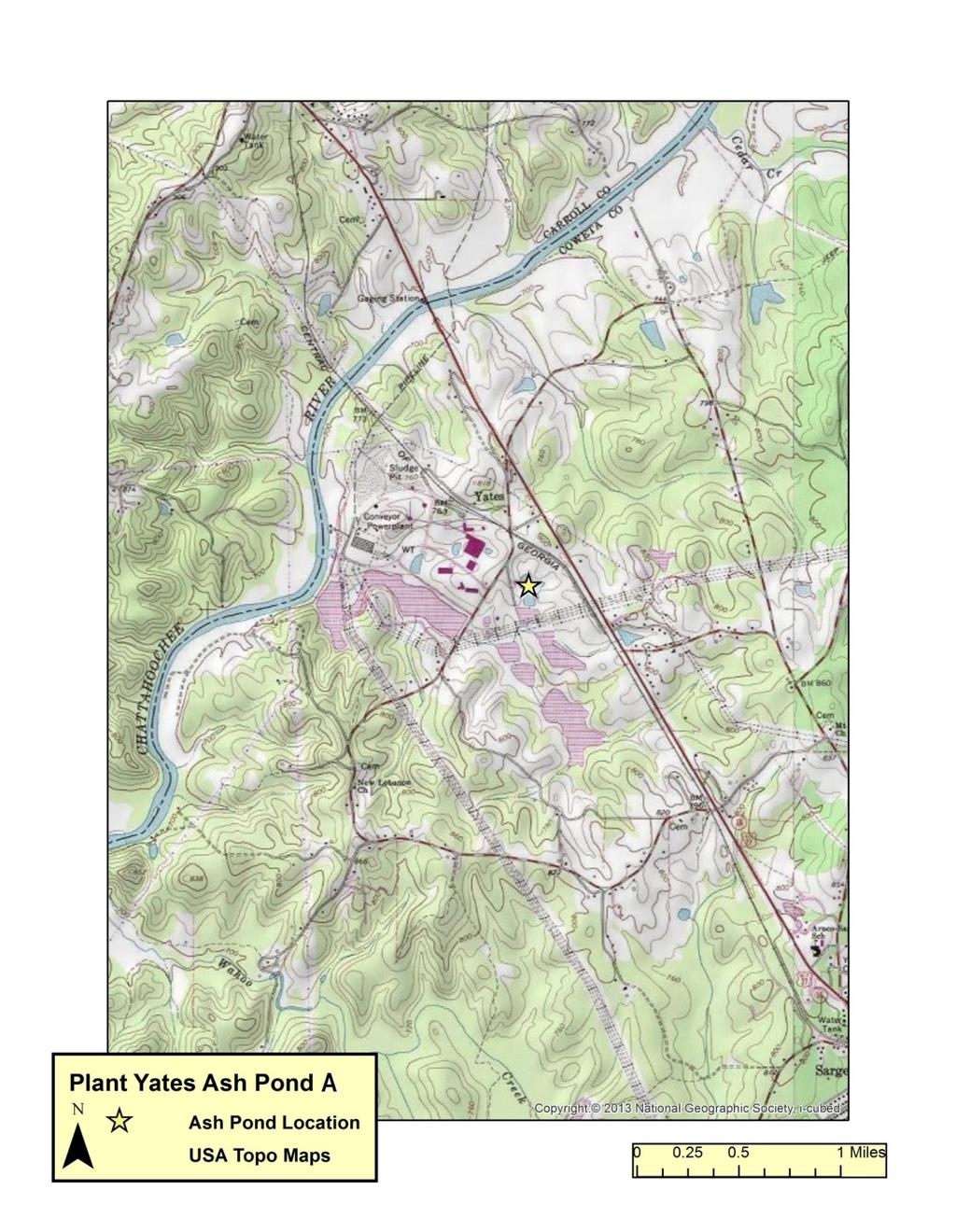
1 HISTORY OF CONSTRUCTION FOR EXISTING CCR SURFACE IMPOUNDMENT PLANT YATES ASH POND A (AP-A) 40 CFR (c)(1)(i)-(xii) (i) Site Name and Ownership Information: Site Name: Site Location: Site Address: Owner: Address: CCR Impoundment Name: NID ID: Eugene A. Yates Power Plant Newnan, Georgia 708 Dyer Road Newnan, GA Georgia Power Company 241 Ralph McGill Boulevard Atlanta, GA Plant Yates Ash Pond A (AP-A) NA EPA s Disposal of Coal Combustion Residuals from Electric Utilities Final Rule (40 C.F.R. Part 257 and Part 261), (c)(1), requires the owner or operator of an existing CCR surface impoundment to compile a history of construction. To the extent feasible, the following information is provided: (ii) Location of CCR Unit: , See Location Map in the Appendix (iii) Purpose of CCR Impoundment: The Eugene A. Yates Power Plant (Plant Yates) was once a seven-unit, coal fired, power generation facility. Currently Plant Yates Units 1-5 are in the process of demolition and Plant Yates Units 6 and 7 have been converted to natural gas. AP-A was designed to receive and store coal combustion residuals produced during the electric power generating process at Plant Yates. AP-A hasn t received ash for a number of years. (iv) Watershed Description: Plant Yates and AP-A are located within the Acorn Creek-Chattahoochee River HUC 12 watershed which has a total area of 28,284 acres. The Acorn Creek-Chattahoochee River watershed is part of the larger Middle Chattahoochee-Lake Harding HUC 8 watershed which has an area of 1,950,182 acres. The inflow into AP-A consists of the rainfall that falls within the limits of the surface impoundment and runoff from the adjoining 42-acre watershed.
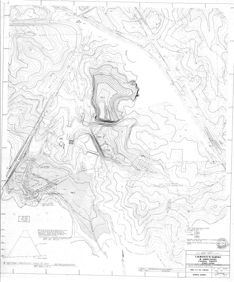
2 (v) Description of physical and engineering properties of CCR impoundment foundation/abutments: AP-A is located in the Piedmont Physiographic Provence of Georgia. The Piedmont is characterized by igneous and metamorphic rocks. According to the Geologic Map of Georgia, 1976, Plant Yates is located in an Undifferentiated Granite formation of the Piedmont. The residual soils in the Piedmont are a result of weathering of the underlying bedrock. Boring information in the area of AP-A indicates the presence of Piedmont residual soils and alluvial soils (due to its proximity to the Chattahoochee River) consisting of firm clayey sand and silty sand within the footprint of AP-A. (vi) Summary of Site Preparation and Construction Activities: AP-A was constructed in 1976 by AMAX Fly Ash Corporation, at the time providing coal ash handling services at Plant Yates, as a temporary pond with a surface area of 8.9 acres. The original configuration of the Ash Pond was an engineered cross-valley embankment. AP-A, as well as the area downstream of the dike, however, was filled in, effectively eliminating the configuration of the original dike structure. All ash has been removed from AP-A as part of closure by removal. The original dike has been breached, and the dike remnants are not capable of retaining water. Stormwater runoff from AP-A flows overland and through ditches into the Ash Pond 2 system. As this was originally constructed by a contractor for temporary purposes, there are no available design or construction documents available. Drawings showing the topography and location of AP-A are included in the appendix as engineering diagrams. (vii) Engineering Diagram: The following drawings relevant to the location and topography of Plant Yates AP-A can be found in the Appendix: 1976 Topography Map with Proposed Section for Dike Construction 1984 Topography Map showing AP-A as closed 1995 Compilation Drawing Showing the Location of AP-A (viii) Description of Instrumentation: There is currently no instrumentation at AP-A. (ix) Area-capacity curves: Due to intentional breaches in the embankment, AP-A is not capable of storing water and run-off into AP-A is routed into Ash Pond 2. (x) Spillway/Diversion design features and capacity calculations: Several breaches have been constructed in the dike protrusion, and the dike remnants are not capable of retaining water. Stormwater runoff from AP-A flows overland and through ditches into the Ash Pond 2 system. (xi) Provisions for surveillance, maintenance and repair: Prior to closure, inspections of dikes were conducted on a regular basis at least annually by professional dam safety engineers and at least weekly by trained plant personnel. The inspections
3 provided assurance that structures were sound and that action was taken, as needed, based on the findings. During annual inspections, dam safety engineers assessed instrument readings, inspected any maintenance or remediation performed since the previous inspection, checked the status of work recommended at prior inspections, ensured that the posting of emergency notification information is up to date and evaluated any items noted during plant personnel inspections. Construction specifications: As this was originally constructed by a contractor for temporary purposes, there are no design or construction documents available. (xii) Known record of structural instability: There is no known record of structural instability at the CCR unit.
4 Appendix
5
6
7