Box 1: Some quotes on the need for detailed deep aquifer investigations
|
|
|
- Rosamund Horton
- 5 years ago
- Views:
Transcription
1 1 CHAPTER Final Report on Development of Deep Aquifer Database and Preliminary Deep Aquifer Map 01 Introduction 1.1 Background Deep aquifer groundwater has been a matter of interest for the Bangladeshi and foreign water scientists for at least two decades. It has become more important currently as a source of arsenic safe water water (charkraborti et al. 1999; Ahmed, 2003; Ahmed, 2003) However, no large-scale investigation has so far been conducted to address the issues raised by various authors and studies. The present study is the first of this kind to address the issue of deep aquifer from a wider perspective though some localized studies have been conducted over the years. Since the detection of arsenic in Bangladesh groundwater in early 90s, the deep aquifer investigation has gained further importance as this is considered as one of the main sources for arsenic safe water. Though there are various important aspects of deep aquifer investigations, the present study is not a complete one and addresses the issues as per the Terms of References. Box 1: Some quotes on the need for detailed deep aquifer investigations "--- resources assessment of the lower aquifer sequence requires sufficient data to establish system geometry and continuity, aquifer transmissivity, and areas and rates of annual recharge" - MPO, 1987 "Very few data exist for the lower aquifer sequence and only very preliminary estimates of groundwater occurrence are available. Quality and quantity of water in the lower aquifer sequence can not yet be established" - MPO, "Only exploration of deep aquifers can provide quantitative analysis of water of the deep aquifers and the amount of recharge these aquifers can take following their exploitation" - Khan, "In view of the progressive shortage of water, the urgency of the exploitation of deep aquifer lying unused cannot be over emphasized. Such exploration will also open the door for investigation whether filtered flood water can be pumped down after exploitation of deep aquifers and use them as storage reservoir for dry season" - Khan, "In particular, research was encouraged into the geochemistry of the deep aquifer sediments and groundwater, including the aquitard separating the shallow and deep aquifers, and the mobility of arsenic in this zone. Also, it was recommended that a resource evaluation be conducted to predict the sustainable yield from deep aquifer in Southern Bangladesh and the possible environmental consequences of widespread exploitation" - DPHE/UNICEF/WB, "Experts believe that mapping of the aquifers is an essential pre-requisite to any decision on the long-term development of groundwater in arsenic affected areas. Where shallow contaminated aquifer is separated from a deeper aquifer by substantially thick impervious layer, water from the deep aquifer could be tapped for drinking water as a short term measure. There are areas where water may be available in aquifers - deeper than the contaminated shallow aquifers. However, there is no reliable data or information about the characteristics of the aquifers, or the existence of any impermeable layer separating the deeper aquifer from the contaminated upper aquifer" - Implementation Plan for Arsenic Mitigation in Bangladesh, 2004.
2 02 Final Report on Development of Deep Aquifer Database and Preliminary Deep Aquifer Map 1.2 Terms of References and Expected Outputs The consultancy works for Support to DPHE in Preparation of a Deep Aquifer Database and Preliminary Aquifer Map has been undertaken as per agreement signed DFID and JICA in July 2005 and subsequent amendment to the contract signed in September The main objectives of the consultancy are: To provide support to DPHE in preparing a database including lithological and water quality data; To prepare a preliminary deep aquifer map; and To recommend for future development of database and maps As set in the TOR, the main purpose of the project is to crate a database of all available and useable lithological and water quality information on the deep aquifer and based on this to prepare preliminary deep aquifer maps such as: Making of aquifer maps Geological profile should be made as much as possible, and aquifer map will be created. Deep aquifer map will be able to make following various types. Distribution map and isopach map of deep aquifer Distribution map and isopach map of upper clay layer Distribution map and isopach map of upper gravel layer Making of standard log format In future, it will be important to improve the record of log information in order to make more effective deep aquifer map. DPHE standard log format should be created in this project. The standard format will be finally made up with idea for draft format from District and Upazila engineer. This standard format should be improved with field experiences as the need arises. 1.3 Geological Background All authors have divided Bangladesh into 3 major physiographic units, the Tertiary Hills, Pleistocene Uplands and Holocene Plains (Rashid, 1977; Khan, 1991; Reiman, 1993). Occurrence and quality of groundwater is by and large, controlled by the major physiographic units as described by Ahmed et al. (2004). Figure 1.1 shows the major stratigraphic units of the country. Table 1.1 shows the major stratigraphic units along with predominant lithologies.

3 Final Report on Development of Deep Aquifer Database and Preliminary Deep Aquifer Map 03 Figure 1.1: Major physiographic units of Bangladesh (from Ahmed et al., 2004).
4 04 Final Report on Development of Deep Aquifer Database and Preliminary Deep Aquifer Map Table 1.1: Main Stratigraphic Units of the Bengal Basin (from BGS & DPHE, 2001) Age Group Formation Lithology Holocene Alluvium Silt, sand, gravel and clay Pleistocene/ Pliocene Madhupur Alluvium Dihing/ Madhupur Clay Yellow to yellowish gray, massive, fine to medium sandstone and claystone/ sticky clay Dupi Tila Yellow to ochre, pink, light brown, light gray to grayish-white sandstone, siltstone and conglomerate. Several oxidized, iron-rich, clayey paleosols and petrified wood. Pleistocene/ Pliocene Tipam Girujan clay Grey to greenish gray, red mottled, silty shale, shale and clay stone Tipam Sandstone Light yellow to yellowish gray, gray, brownish gray and orange fine to medium grained sandstone, siltstone and shale Miocene Surma Bokabil Greenish to bluish gray and yellowish gray marine pyretic shale, siltstone and very fine to medium grained sandstone, marine fossils Bhuban Gray to bluish gray fine to medium sandstone, siltstone and claystone Oligocene Barail (Bogra in NW Bangladesh) Brown, yellow-brown, pink and gray sandstone, siltstone and carbonaceous shale Late Eocene Jaintia Kopili Grey, greenish grey to black silty claystone, fossiliferous shale, thin beds of glauconitic sandstone and limestone Eocene and Paleocene Sylhet Limestone Kopili Grey to grayish brown massive numulitic limestone Tura Grey, brown, pink and grayish-white ferruginous sandstone, coal and shale Late-Middle Cretaceous Upper Gondwana Kopili Shibganj Trapwash Coarse yellow brown sandstone, white clay, volcanic ash Early Cretaceous- Rajmahal Traps Amygdaloidal basalt; serpentinized andesites, shale; agglomerate Late Permian Lower Gondwana Paharpur Sandstone, felsdpathic greywacke, coal, shale; coarse sandstone Early Permian Lower Gondwana Kuchma Coarse grained sandstone, shale, thick coal seams Precambrian Basement Complex Gneiss and schist
5 Final Report on Development of Deep Aquifer Database and Preliminary Deep Aquifer Map 05 Table 1.2: Aquifer Potential Related to Stratigraphy of Bangladesh (modified from MPO, 1987) Age Rangpur Saddle Bogra Slope Rangpur and Bogra Shelf Geosyncline Aquifer Potentials Age Group/Form ation Cumulative Thickness Group/Form ation Cumulative T h i c k n e s s Lithology Group Formation Lithology Cumulative T h i c k n e s s Holocene (Recent) Alluvium 50 Alluvium 80 Sand, silt and clay Alluvium Sand, silt and gravels Cumulative Thickness 450 Excellent for all over Bangladesh UNCONFORMITY Pleistocene Madhupur Clay 70 M a d h u p u r Clay 100 Clay, sandy clay, yellow brown, M a d h u p u r Clay Pebbly sandstone overlain by app. 20m silty clay 490 Good in NW and NE Bangladesh where sandstone member developed UNCONFORMITY Middle Pliocene to Late Miocene Dupi Tila Formation 240 Dupi Tila Formation 370 Sandstone with subordinate pebble bed, grit bed and shale Dupi Tila Poorly crossbedded coarse ferruginous sandstone with quartz pebbles and petrified wood 2320 Good in NW Bangladesh, Sylhet and Chittagong Hills but unknown elsewhere because of greater depth of occurrences
6 06 Final Report on Development of Deep Aquifer Database and Preliminary Deep Aquifer Map Age Rangpur Saddle Bogra Slope Rangpur and Bogra Shelf Geosyncline Aquifer Potentials Age Group/Form ation Cumulative Thickness Group/Form ation Cumulative T h i c k n e s s Lithology Group Formation Lithology Cumulative T h i c k n e s s UNCONFORMITY Early Miocene Surma Group (undifferenti ated) 360 Jamalganj Formation 780 Fine to medium grained sandstone, sandy and silty shale, siltstone, shale Tipam Girujan Clay Claystone and subordinate siltstone and sandstone 3390 Generally poor to none but moderate at Sylhet and Chittagong Hills Tipam Sandstone Coarse grained cross bedded sandstone with pebbles of shale, granite quartzite, quartz and small pieces of lignite; argillaceous beds mostly at the lower part Moderate in Sylhet and Chittagong Hills, elsewhere none Surma Bokabil Upper part dark gray marine shale with pyrite; lower part shale and sandstone 6420 Moderate in NW Bangladesh, elsewhere unknown
7 Final Report on Development of Deep Aquifer Database and Preliminary Deep Aquifer Map 07 Age Rangpur Saddle Bogra Slope Rangpur and Bogra Shelf Geosyncline Aquifer Potentials Age Group/Form ation Cumulative Thickness Group/Form ation Cumulative T h i c k n e s s Lithology Group Formation Lithology Cumulative T h i c k n e s s Bhuban Intraformational breccias with marine fossils; shale, sandy shale and sandstone NW Bangladesh, elsewhere unknown UNCONFORMITY Oligocene Bogra Formation 940 Siltstone, carbonaceo us shale and fine grained sandstone Barail Jenam Siltstone, carbonaceo us shale, and fine grained sandstone Claystone and subordinate siltstone and sandstone Good in NW Sylhet where the sandy unit outcrops, elsewhere probably negligible UNCONFORMITY Late Eocene Kopili Formation 980 Sandstone, locally glauconitic and highly fossiliferous, shale with calcareous bands Moderate in Rajshahi and Bogra
8 08 Final Report on Development of Deep Aquifer Database and Preliminary Deep Aquifer Map Age Rangpur Saddle Bogra Slope Rangpur and Bogra Shelf Geosyncline Age Group/Form ation Cumulative Thickness Group/Form ation Cumulative T h i c k n e s s Lithology Group Formation Lithology Cumulative T h i c k n e s s Middle to late Eocene Sylhet Limestone Formation 1170 Numulitic limestone with sandstone interbeds Middle Eocene to early Eocene Tura Sandstone 490 Tura Sandstone Formation 1270 Gray and white sandstone with subordinate greenish gray shale and coal UNCONFORMITY Late Cretaceous Shibganj Formation (Trapwash) 1400 Coarse yellow brown sandstone, volcanic material, white clay Aquifer Potentials Moderate to good in fractured and sandy unit in Rajshahi, Bogra and Garo-Jaintia foothills Generally good in NW Bangladesh but occasional presence of coal seams make aquifer potential poor Good in NW Bangladesh
9 Final Report on Development of Deep Aquifer Database and Preliminary Deep Aquifer Map 09 Age Rangpur Saddle Bogra Slope Rangpur and Bogra Shelf Geosyncline Age Group/Form ation Cumulative Thickness Group/Form ation Cumulative T h i c k n e s s Lithology Group Formation Lithology Cumulative T h i c k n e s s UNCONFORMITY Late Jurassic to Middle Cretaceous Rajmahal Trap 1700 Amygdaloidal basalt, serpentized shale and agglomerate UNCONFORMITY Late Permian Gondwana Sediments 660 Paharpur Formation 2120 Feldspathic sandstone, shale and Kuchma Formation 2610 Sandstone and grit with subordinate shale interbedded with coal beds UNCONFORMITY Precambrian Basement complex Basement complex Gneiss, schist, granodiorite, quartz diorite Aquifer Potentials None but could have a moderate potential if enough vesicles are present Generally poor because of presence of mineralized coal bearing strata in Jamalganj and Kuchma basins but good at Rangpur Saddle where sandstone is preserved at Gondwana halfgraven structure None
10 10 Final Report on Development of Deep Aquifer Database and Preliminary Deep Aquifer Map 1.4 Hydrogeological Setting of Bangladesh Groundwater occurs in the extensive unconsolidated sedimentary aquifers all over the country at varying depths. The country has been divided into number of hydrogeological provinces by various authors (Hyde, 1978; UNDP, 1982; MPO, 1987). A simplified hydrogeological classification has been provided by Ahmed (2003) Figure 1.2: Major hydrogeological provinces of Bangladesh (after Ahmed, 2003)
. However, if minor details are considered the number of units increase up to 40 (UNDP 1982, MPO 1987).")
11 Final Report on Development of Deep Aquifer Database and Preliminary Deep Aquifer Map 11 by dividing the whole country into 6 major hydrogeological units as shown in Figure 1.2. The country can be broadly divided into six major hydrogeological units (Ahmed 2003). However, if minor details are considered the number of units increase up to 40 (UNDP 1982, MPO 1987). Figure 4 shows the major hydrogeological zones of the country which are: Zone I - Holocene Piedmont Plains, Zone II - Holocene Deltaic- and Floodplains, Zone III - Pleistocene Terraces, Zone IV - Holocene Depressions, Zone V - Tertiary Hills, and Zone VI - Holocene Coastal Plains. Aquifer conditions and quality of groundwater vary significantly from unit to unit. Groundwater levels of the shallow aquifers lie very close to the surface and fluctuate with annual recharge discharge conditions. Water level rises during the monsoon and declines during the dry season due to lack of recharge and large scale irrigation abstractions. The amount of dry season fluctuations over most of the country are becoming more and more accentuated due to large scale irrigation abstractions and in certain areas a declining trend is detectable. Very little information is about the water level behaviors of the deep aquifers. It is perceived that groundwater is under artesian conditions in the deep aquifers. Limited data show that the deeper aquifer water levels also fluctuate annually almost in the same fashion as the shallow groundwater (Zheng et al., 2005). Figure 1.3: Groundwater flow system showing local, intermediate and basinal flow lines. The basinal groundwater flow system may exist beyond political boundaries where trans-boundary flows can be significant. In Bangladesh it is very likely that the deep flow systems are of trans-boundary nature, particularly in the areas where the elevation differences are high on either side of the political border as in Sylhet region (from

12 12 Final Report on Development of Deep Aquifer Database and Preliminary Deep Aquifer Map Generally vertical movements of groundwater take place only in the upper few meters. In the lower part of the shallow aquifer and in deep aquifer the groundwater moves horizontally, mainly from north to south. The shallow groundwater movement is influenced by the presence of surface water bodies and irrigation abstractions. Ravenscroft (2003) postulates the existence of the following three different flow systems in the Basin operating simultaneously but at different scales: A local flow system operating to a depth of 10 meters or so between local topographic highs (terraces or levees) and depressions (bils or streams). The flow system includes the zone of annual fluctuation of the water table. The flow paths are probably a few hundreds of meters to a few kilometers, and residence times a few years to a few tens of years. An intermediate scale flow system, penetrating to depths of the order of hundred meters, between extensive topographic highs (hills and terrace areas) and the major regional rivers. Flow paths are tens of kilometers long and residence times in the order of thousands of years. A basinal scale flow system, to depths of hundreds of thousands of meters, between the tectonic boundaries of the Bengal Basin (the Tripura Hills, the Shillong Plateau, and the Rajmahal Hills) and the Bay of Bengal. Flow paths are hundreds of kilometers long and residence times are more than ten thousand years. Figure 1.4: NS Geological cross section across Bangladesh (Source: GWH, BWDB)

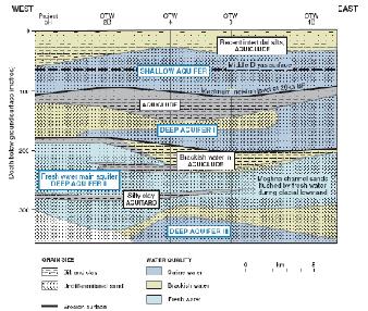
13 Final Report on Development of Deep Aquifer Database and Preliminary Deep Aquifer Map 13 Integrating flow system and groundwater chemistry, Ravenscroft (2003) proposes a threefold classification of groundwater in Bangladesh: modern waters with active circulation in local system; semi-connate waters in intermediate or basinal flow systems; and paleo-flow system waters. Each water system has distinct chemical composition. The deep aquifer water falls into the last two categories. Groundwater quality over most of the country is good for drinking and irrigation purposes. However, widespread presence of arsenic, iron, manganese and localized occurrences of some other heavy metals makes water unsuitable for drinking purposes without pre-treatment. 1.5 Review of Aquifer Systems of Bangladesh The unconsolidated river borne alluviums and semi-consolidated sedimentary sequences form extensive aquifers over most of Bangladesh. In the Bengal Basin a very thick succession of Tertiary sediments are deposited reaching up to a depth of than 15 km near the Bay of Bengal coast. However, from hydrogeological point of view the upper few hundred meters is important from where good quality water can be abstracted using available technology at economically feasible cost. For this reason all major hydrogeological investigations in the country attempted to classify the sedimentary sequence hydrostratigraphically. In this section a review of the existing descriptions of the aquifer system has been made. First systematic classification of the aquifer systems of Bangladesh, based on lithological information stored at the Ground Water Hydrology (GWH) of Bangladesh Water Development Board (BWDB) was made by UNDP (1982). According to this three fold classification the aquifers of the country, up to a depth of around 140m, have been divided as upper or composite aquifer, main aquifer and deep aquifer. Though this classification has been made based on the borehole information stored at BWDB, its regional cross sections drawn both in north-south and east-west directions, as shown in Figure 1.4 and 1.5 respectively, do not show a well defined three fold aquifer system as proposed. Figure 1.5: EW Geological cross section across coastal areas of Bangladesh (from GWTF, 2002)
14 14 Final Report on Development of Deep Aquifer Database and Preliminary Deep Aquifer Map Master Plan Organization (MPO) during the formation of National Water Plan analyzed more than shallow borelogs from all over the country. Combining this analysis with the limited number of deep oil and gas exploration well log analysis by Jones (1985), two aquifer sequences, Upper and Lower, were proposed for the Miocene-Pleistocene and Holocene sediments (MPO, 1985). The Upper Aquifer Sequence has been defined as hydraulically continuous heterogeneous assemblage of sands, silts and clays up to a depth of about 240m. The upper aquifer sequence has been further subdivided into Silty Clay, Composite Aquifer and Main Aquifer, which uses the model of UNDP, 1982 classification. The deep Aquifer of UNDP (1982) classification has been included into the Lower Aquifer Sequence and further divided into five aquifers separated by clay aquitards. Aquifer No 2 of this classification is the deep aquifer of the UNDP (1982) classification. Table 1.3 presents the hydrogeological classifications of the Miocene-Holocene sediments in Bangladesh as described in MPO (1987). Table 1.3: Hydrogeological Classification of the Miocene-Holocene Sediments in Bangladesh (MPO, 1987) Aquifer Sequence Sub-units Thickness Recharge Area (km2) Comments Upper Aquifer Sequence Silty Clay 0 to Hydrogeological characteristics and water resources well defined based on over 17,000 Composite Aquifer 3 to 60 well logs Main Aquifer 30 to 60 Lower Aquifer Sequence Clay Aquitard 20 to 80 Minimum 2500, Hypothetical based on 36 well logs and 20 maximum 3900 geo-electrical logs. Hydrogeological Aquifer No to 120 interpretation speculative Clay Aquitard 0 to 170 Aquifer No to 180 Clay Aquitard 110 to 140 Aquifer No to 170 Clay Aquitard 100 to 160 Aquifer No to 150 Clay Aquitard 30 to 50 Aquifer No to 190 On the basis of isotopic composition of groundwater IAEA (Aggarwal et al., 2000) reported four different water types at different depths and proposed a slightly modified three fold classifications for the aquifers : First Aquifer (70-100m), Second Aquifer ( m) and Third Aquifer (>300m) as shown in the following Figure 1.6. The first aquifer, extending up to a depth of 100m, is characterized by modern groundwater (less than 100 years old), high arsenic and continuous recharge. The second aquifer, extending up to a depth of m, is characterized by old water of about 3000 years, arsenic free and lack of natural recharge. However, there is pumping induced recharge to this aquifer from the first aquifer. The third aquifer, occurring at depth of m, is characterized by very old water in the range of 20,000 years, arsenic free and devoid of any natural recharge.


15 Final Report on Development of Deep Aquifer Database and Preliminary Deep Aquifer Map 15 Figure 1.6: Proposed aquifer system for Bangladesh (from Aggarwal et al., 2000) BGS & DPHE used the UNDP three fold classification has been used with new nomenclature. Here the aquifers have been divided as Upper Shallow Aquifer, Lower Shallow Aquifer and Deep Aquifer as shown in Figure 1.7. Figure 1.7: NS Geological Cross Sections across Bangladesh showing the three-aquifer systems (from BGS & DPHE, 2001)

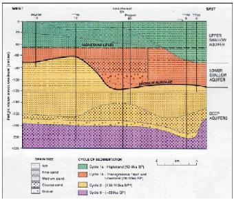
16 16 Final Report on Development of Deep Aquifer Database and Preliminary Deep Aquifer Map The Ground Water Task Force (2002) in their report provided a classification from geological point of view. According to this classification, as shown in Figure 1.8, the major aquifers are: Upper Holocene Aquifer, Middle Holocene Aquifer, Late Pleistocene-Early Holocene Aquifer and Plio-Pleistocene Aquifer. Upper Holocene Aquifers Mid Holocene Aquifers Late Pleistocene-Early Holocene Aquifer Pleistocene Clay Plio-Pleistocene Aquifers Figure 1.9: Schematic geological classification of aquifers of Bangladesh (from GWTF, 2002) The Upper Holocene aquifer is not exposed in all the deltaic and flood plain areas. The lower part of the aquifer is composed silt and clay at the bottom and fine sand at the top. The upper part is composed of silt and clay. The middle Holocene aquifer varies widely vertically and horizontally and is composed of fine sand becoming coarser in the upper part. The late Pleistocene- Early Holocene aquifer is characterized by coarse sands with widespread gravels. The Plio-Pleistocene aquifer consists of Dupi Tila sands overlain by a thick silty clay layer of Pleistocene age. The sands of this aquifer unit are medium to coarse with pebbles. The geological model of GWTF (2002), however, does not consider the north-south variations in depositional environment and aquifer disposition. Ahmed (2003) presents the following model dividing the aquifers into two different age groups, i.e. Holocene and Plio-Pleistocene as shown in Figure 1.9. These kind of lateral variations have been established from deep geological cross sections prepared with hydrocarbon exploration logs as shown in Figure The schematic aquifer disposition demonstrates that how same sedimentary sequence can be found at different depths depending on the geographical location. This also demonstrates how the same aquifer can be found at shallow or deeper depths according to geomorphological setting of the area.
 Figure 1.")
 It is therefore important to have a geochronological classification of the aquifers of Bangladesh.")
17 Final Report on Development of Deep Aquifer Database and Preliminary Deep Aquifer Map 17 Figure 1.9: Schematic NS geological section showing the aquifer units of Bangladesh (after Ahmed, 2003) Figure 1.10: NS Geological cross section drawn with deep petroleum exploration logs (from GWTF, 2002 after Alam et al., 1990) It is therefore important to have a geochronological classification of the aquifers of Bangladesh. The classification should address the depositional environment and geomorphological conditions of the area as well. Considering this the following aquifer classification system has been proposed by this study for Bangladesh as shown in Figure The classification scheme includes the Tipam formation as major aquifer, particularly in the coastal region. This formation serves as the deep aquifer in West Bengal part of the basin (Dr. Sinha Ray, former Member, Central Ground Water Board, India; personal communications). Table 1.4 presents the summary of aquifer system of Bangladesh along with major areas of occurrences. Chrono Stratigraphy Gelogic age Aquifer characteristic Northern area Southern area Alluvium Holocene Shallow Shallow Chandina Formation/ Jamuna Formation Late Pleistocene Shallow Deep Dupi Tila Early Pleistocene Shallow / Deep Deep Tipam Pliocene Deep Deep
18 18 Final Report on Development of Deep Aquifer Database and Preliminary Deep Aquifer Map Table 1.4: Comparison of Aquifer Systems of Bangladesh Aggarwal et al., Aquifer Units UNDP, BGS& DPHE, 2001 JICA, 2002 GWTF, 2002 Major Occurrences 1 Upper/Composite Aquifer 1st Aquifer Upper Shallow Aquifer Upper Aquifer Upper Holocene Aquifer Unconfined aquifer consisting of river borne sands and gravel and fan deposits occurring at surface in the NW; covered by a thin clay/silt aquitard in the flood plain and delta regions; covered by a thick clay in Sylhet Basin; absent in the hilly regions 2 Main Aquifer 2nd Aquifer Lower Shallow Aquifer Mid Aquifer Middle Holocene Aquifer Semi confined/leaky aquifers consisting of fine to medium and coarse sands with localized thick gravel beds; occur within 100m from ground surface over most of the plains of the country; occur at greater depths in the Sylhet Basin; absent in the hilly regions. 3 Deep Aquifer 3rd Aquifer Deep Aquifer Deep Aquifer Late Pleistocene- Holocene Aquifer Confined aquifers consisting of fluvio-deltaic fine to medium sand with occasional gravels; occur at around 30m under the Madhupur/Barind Clay in the Madhupur/Barind Tracts; occur at deeper depth in other plains; occur at surface in the hilly regions. 4 Plio-Pleistocene Aquifer Confined aquifers consisting of fluvio-deltaic fine to medium sand with occasional gravels; occur at around 30m under the Madhupur/Barind Clay in the Madhupur/Barind Tracts; occur at deeper depth in other plains; occur at surface in the hilly regions.
19 Final Report on Development of Deep Aquifer Database and Preliminary Deep Aquifer Map Deep Aquifer Definition From the descriptions in the previous section it is evident that the term Deep Aquifer has been made part of the aquifer system of Bangladesh by all the different authors. However, there are confusions and misunderstandings about the term "deep aquifer". The various different definitions proposed for the deep aquifer are briefly reviewed below: Morton and Khan (1979) describe the deep aquifer from Barisal and Patukhali districts as the one that occurs at depths ranging from 238 to 328m with an average thickness of 32m consisting of several hydraulically interconnected stratigraphic horizons. They also report that the deep aquifer is overlain and protected from vertical intrusion of saline water by a 65 to 165m thick clay layer. Jones (1985) describes the saturated deep Tertiary sequences, identified from the electrical logs of oil and gas wells at the depths of 1000 to 3000m, as the deep confined aquifers. MPO (1987) based on the information of Jones (1985) proposed the term Lower Aquifer Sequence for the aquifers occurring underneath the main aquifer of UNDP, Khan (1991) defined deep aquifer as "those aquifers whose waters have no access vertically upward or downward but flow very slowly along the dips and slopes of the aquifer. The depths of the deep aquifers containing useable water range from 600 feet to 3000 feet on the Dinajpur platform and 800 feet to 5000 feet in the basin". Khan (1991) also mentioned that the deep aquifers included sediments of the Gondwana, Jaintia, Surma, and Tipam Groups and parts of the Dupi Tila Sandstone formation. The proceedings of the review meeting on deeper aquifer, first ever meeting on deep aquifer, held in August 2000 in Dhaka (DPHE/UNICEF/WB, 2000) dealt in length with the definition of the deep aquifer. It was agreed at the meeting that deep aquifer should not be defined in terms of depth where the depth would depend on local/regional hydrogeological conditions. There should be an aquitard or aquiclude separating the shallow and deep aquifers. DPHE & BGS (2001) considered the red brown Dupi Tila of the Chandina area, and Barind Madhupur Tracts and grey sub-150m deep aquifers composed of cyclic, vertically stacked aquifers in the subsiding delta as the deep aquifer. DANIDA/DPHE (2001) aquifer containing fresh water and occurring in the depth range of 220 to 350m in the coastal regions. JICA (2002) hydrogeologically defined deep aquifer as consisting of D and E formations of Pleistocene age at depths of 160 to 220m in their study area in Jessore, Jhenaidah and Chuadanga districts of SW Bangladesh. These formations can be correlated with the Pleistocene Madhupur Formation. Ravenscroft (2003) defined deep aquifers as those accessible to current water well technology (<350m) and already developed by hand tubewells and locally by production tubewells (e.g. Khulna). He termed the deep aquifers of Jones and Khan as "super-deep" aquifers and commented that it was unlikely that their exploitation would be economically viable for the foreseeable future. Zheng et al. (2005) defined shallow (<28m) and deep (40-90m) aquifers in a local case study from Araihazar Upazila of Narayanganj district based on hydrogeological and hydrogeochemical contrasts.
20
21
22
23
24
25
26