LAKE RESTORATION, ISSUES & APPLICATION THE CASE OF BANGALORE
|
|
|
- Anabel Marsh
- 5 years ago
- Views:
Transcription
1 LAKE RESTORATION, ISSUES & APPLICATION THE CASE OF BANGALORE Rajshekhar Rao Asst. professor M.S. Ramaiah Institute of Technology Bangalore
2 INTRODUCTION Associated Values of Lakes and their importance Lakes are the lungs of natural ecosystems and perform several functions. Urban Lakes are however, only a subset of all fresh water bodies, i.e., Reservoirs, Lakes, Ponds, Tanks; etc. The lakes have inherent quality of storing and maintaining it for a much larger period than other wetlands.
3 In recent years, there has been increasing concern over the continuing degradation of world's wetlands, particularly rivers and lakes. Lakes sustain all life and perform useful functions in the maintenance of ecological balance. Interfacing between land and water systems, they are highly productive and biologically rich ecosystems, and are also the most endangered. It is part of India s national policy to conserve the existing lakes and plan and devise Environment Management plans. Efforts to conserve these fragile areas and develop them to promote eco-tourism should be undertaken to make aware and sensitive towards environment and protection of our natural resources.
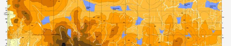
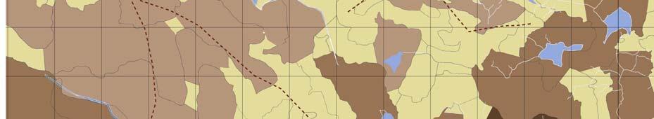
4 Figure 1: Study Area Greater Bangalore Study area - Bangalore Wetlands of Bangalore occupy about 4.8% of the geographical area (640 sq km) covering both urban and non-urban areas. Bangalore gao has many manmade wetlands


 within the")

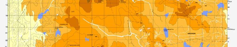
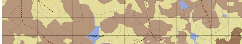
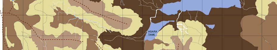
5 Figure 2: Map showing lakes in Bangalore In Bangalore the lakes were built for various hydrological purposes and mainly to serve the needs of irrigate agriculture. There were 262 lakes (in 1960) within the Green belt area of the city, which has fallen to 81 at present.


6 Lakes in Bangalore are threatened due to Industrialization Urbanization and unplanned growth


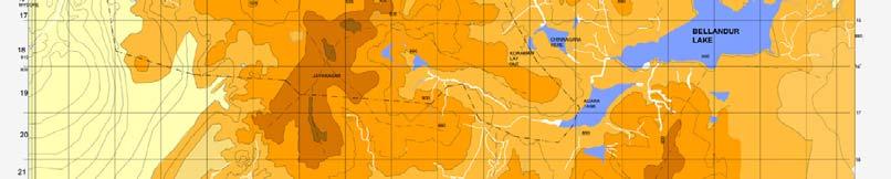
7 Criteria for Selection of Bellandur Lake Bellandur Lake is the largest in Bangalore city, being 3km in length and 2.75km in Width. It is one of the largest man-made lakes in Southeast Asia, located about 20 km from the city towards the South-East t of Bangalore city which h is extremely important ecological zone. Bellandur lake


8 Historically, Bellandur Lake used to irrigation to the downstream 25,000 acres of agricultural fields. Bellandur Lake functioned as the kidney of the city. The lake was home to a wide variety of fauna and attracted many migratory birds. The lake also provided d drinking water to half the city's population. p In the past lake was a major fish trading


9 Present Condition of Bellandur lake 3km in length and 2.75km inwidth overall catchments area is sq.miles The water storing capacity of Bellandur lake is million cubic feet.


10 Lake polluted due to Discharge of sewage and other wastewater Dumping of solid wastes into the storm water drains pollute the lake. The lake contains raw sewage, Industrial effluents and Domestic garbage. Does not have proper sewerage System.
11 Methodology : primary, secondary and public opinion surveys personal observations site visits and visual surveys were conducted in order to get data related to various aspects and understand the existing conditions. Studies were basically done at two levels- the Catchments Level and the lake Level- to identify the impacts of different natural and human activities on the lake eco-system. Aspects at the Catchments levels are. physiograpy, climate, land use, drainage, demography, socio-economic status, transportation network, infrastructure, and location of industries. Aspects at the lake level are biodiversity, water quality, land use, settlement pattern, socio-economic status, activities in lake, facilities and amenities, and commercial activities. In addition to this, tourism related data has also been analyzed to understand the ecotourism prospects


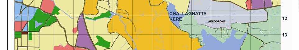
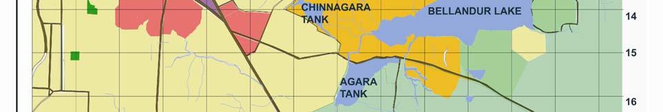
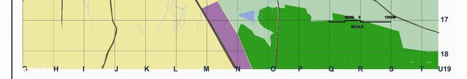
12 Figure 3: Existing land use map of Bellandur lake region


13 Major problems and issues confronting Bellandur lake region: The threats to the Bellandur lake region Eco-system are partly due to biotic pressure from the environment and mainly due to human induced or natural changes in the zone of finfluence. The issues/threats can be broadly summarized as below: Figure 4: issues and causes of Bellandur lake region
14 Table 1: Major issues & Causes of Bellandur Lake Sl Causal Factors impacts Resultant effect. n o 1 Cutting of vegetation tti Increase in soil erosion Lk Lakes becomes Decrease in shallow& transpiration increase in water Increase in storm water spread Increase in flow sedimentation 2 Industries situated t It adds on to Organic Eutrophication ti around the lake release load their effluent in to the B.O.D decreases lake 3 Intensive agriculture It increase the nutrients Profuse growth of around the lake using & pollutants organic the weeds & fertilizers & pesticides. matters inside the lake water hyacinth
15 Environmental Management plan The Environmental Management pan incorporates in the broad land-use plan identification, preservation and protection of the environmentally fragile areas, resource areas, ecological areas, cultural, historical and religious sites, source of pollution, and the environmental hot spots. Proposals are given for environmental quality improvement by restoration, relocation and rehabilitation of certain activities. Provision of adequate green areas, recreational areas and open areas ensure that environmentally sustainable tourism is established. Lastly, various strategies and guide lines and policies have been formulated for environmentally relevant sectors such as Industries, transportation, waste treatment, and tourism.


16 Analysis: The analysis is done to understand the various environmental, social and economic problems on the basis of several criteria such as severity, extent and importance. Also the positive and negative impacts of all the different activities undertaken in the lake are analyzed The Land use in the catchment is critically important. t The development activities in the catchment area like vegetation cutting, housing, development activities, construction of road etc, which increase the erosion rate. Any man made factors affect directly or indirectly affect the quantity and quality of lake water. So it is essential to stop any such activities in the lake The Land use around bellandur la


17 Figure 5: hydrologically sensitive area of Bellandur lake catchment To maintain the existing water quality the identification of hydrological sensitive area are important.so hydrological analysis is carried out. It is observed that the water quality has been reduced d reaching the bellandur lake basin due to various development activity in the catchment area of the lake.
18 Eco sensitive Zones of Bellandur lake Catchment : The lake catchment has been assessed for the three basic resources which are land i.e. slope, Vegetation, and Hydrology. These factors have assigned value depending upon their criticality, by the superimposition of these parameters; it s able to demarcate zones within the catchment as ecologically sensitive zones. The entire catchment has been subdivided in to four ecologically sensitive zones and the treatment of each zone hence varies accordingly.


19 Figure 6: Map showing Ecosensitive zones of Bellandur Lake at Catchments
20 Zone 1 : The outer zone is the Buffer zone of undisturbed vegetation buffered with trees & thick shrubs. Zone 2 : Agriculture zone, where farmers have been and would continue growing crops based on appropriate and sustainable farming principles. Zone 3 : Interface zone, the limits of which zone are determined based on the existence of marshes, ponds and etc on the simple rule that restricts farming on areas adjacent to water courses up to a width equal to at least the width of the stream. Zone 4 : consist of the body of water and its associated vegetation,which are to be left intact as habitat for wild life, particularly waterfowl and migratory birds.
21 Bellandur lake- proposal Ecological Critical factors Proposals Environmental benefits Zone Zone 1 Zone 2 Zone 3 Erosion susceptible Hydrological Zone Afforestation to be done using recycled water can be treated as buffer either ih with ihforest, fruit orchard & declared as green zone. Provide 200mts. Of undisturbed vegetation buffer with high grass percentage than of shrubs & trees. Improvement in the quality of water controls sediment entry. Quality of water entering in to tank ensured. Vegetation Zone, Erosion Preservation of agriculture field.no Dependency on lake susceptible, and development zone around the lake No ensures its maintenance. hydrological zone industrial activity. Forms continuous green space, check the speed of runoff. Natural edge supports natural vegetation. Erosion susceptible, vegetation zone hydrological zone Zone 4 Erosion susceptible, vegetation zone hydrological zone No development zone around the lake No industrial activity 100 mts to 150mts. No construction zone allowed. Forms green space. Check the speed of run off, forms green belt around the lake. Potential wetland habitat area
22 Figure 7: Proposed Land use Map of Bellandur lake
23 Guidelines & proposal for Bellandur Lake The recommendations deal with framing regional policies, guidelines and management tools for the various stake holders. The government should undertake integrated planning and conservation measures in consultation ti with landscape architects, t planners and local people while the developers, operators and suppliers should respect and follow planning restrictions, standard and codes. A Comprehensive Plan be prepared to study with regard to their present status, sustainable use, management and conservation and to formulate strategies for their short term & long term management. The proposed land use map of (see Figure 7)of Bellandur lake deals with Guide lines at regional level which includes Riparian zone management, Management of surface water bodies & Management of recreational area surrounding the lake. Guide lines at Lake Catchment level are as follows
24 Afforestation : To Protect and enhance the existing forest cover and establish new forest cover on suitable areas so that rainfall pattern is not altered and the region receives the maximum precipitation which can be stored as ground water and is made available throughout the year for various uses within the region. Riparian zone management: To establish and protect the riparian zone along the banks of the water bodies and the hydrological channels to act as a buffer between the agricultural lands and the lake. Section through the lake and Riparian zone
25 Management of Agricultural Zone: To promote a ecologically viable cropping pattern and irrigation methods wherein the area under the cultivation of a particular crop should be based on ecological parameters and in the long run should not degrade the land and the quality of water. Management of Urban areas and Industrial zone: No new Industry should be allowed to come up in ecologically sensitive areas and in fertile land. The sewage and sullage from the catchment should be stopped at a point, treated up to acceptable standards and only then be allowed to enter the lake. No new construction to be allowed unless a proper sewage treatment plant is installed. Land use which h should be allowed should be low density development with large open spaces. For each settlement coming under the catchment area percentage allocation for different landuses to support the basic requirements and conserve the ecology of the region should be done
26 Rain water harvesting system: Revive the Traditional water harvesting structure and augment with modern irrigation system. Guide lines for management of Recreational lakes: Newer recreational development happening should be allowed only if the development takes care of the bird habitats and the fish breeding farm near the lake. Guide lines for management of Surface water bodies: Sewage, sullage and toxic wastes shall not be allowed to flow in the tank or percolate in the ground. Natural lake edge conditions of the lake to be preserved. No biotic interference inside the lake as washing, boating etc. should be allowed inside the lake. Depth of the lake should be increased by desilting every 3 years.
27 Table 3: Lake Restoration methods Sl.No Method Advantage Drawbacks 1 Dilution :Flush with low nutrient Water Reduces Nutrient levels, washes out surface algae Require large volumes of water. Does not eliminate sources of phosphorous from, sediments 2 AlumTreatment Lowers lake Phosphorous Content, Reduces the no of beneficial inhibits release of phosphorous from insects in the lake bottom. sediments. Increase water transparency 3 Artificial ifiilcirculation i Prevents stratification, i provide Does not decrease algal l biomass. aeration and oxygenation increase May decrease water clarity. aerobic habitat Adverse impact on cold water fish. No effect on macrophytes. 4 Dredging Controls aquatic vegetation, deepens lake increases lake volume. May improve water quality. 5 Water level draw down Control Macrophytes. Consolidate sediments,facilitate dredging or excavation Temporary resuspension of sediments.temporory destruction of habitats. Disposal concern high cost. Poor effects in wet, mild climates. Short term benefits; intensify algal booms. Temporary adverse impact on fish and invertebrates. 6 Biomanipulation Encourage growth of Zooplankton Considered experimental. Not effective Where blue green algae dominate.
28 Conclusion Wastes and effluents from the power plant and other industries pollute the water of Bellundar Lake. Thus it is necessary to have strict regulations for industrial discharge in to the lake. Since all the lakes in Bangalore are interconnected and interactive ti it s not enough to restore only Bellandur lake & its surrounding catchments area but also overlook into other interconnected wetlands and their catchments areas. The Bellandur Lake holds scope for development of eco-tourism but within some limits. The optimality of the present resource appropriation in light of its sustainability needs to be worked out through further ecological assessments and definite regulatory frame work should be in place. These restoration goals require intensive landscape planning, leadership, and funding, with active involvement from all levels of organization (Governmental, NGO's s, corporate sectors, citizen groups, research organizations, media, and so forth) through interagency and intergovernmental processes instrumental in i iti ti d i l ti th t ti
29 THANK YOU