Surface Geothermal Features
|
|
|
- Valerie Shannon Wood
- 5 years ago
- Views:
Transcription


1 Surface Geothermal Features Brad Scott Bridget Robson BOP RC IEA-GIA Environmental Mitigation Workshop,, Taupo, June 15, 2012
2 Introduction (1) Geothermal surface features have many values Intrinsic, amenity, economic, social and cultural Uses included heating, bathing, tourism, volcano monitoring and research Provide landscape diversity Provide unique ecosystems Development of geothermal energy has an adverse impact on surface features
3 Introduction (2) They are an expression of the subsurface geothermal system Can be used to determine parameters of the sub surface system Indicator of system behaviour, response to reservoir utilisation (and natural state) Fundamental science (locations, heat output, chemistry etc) supports informed management decisions/options
4 NZ Geothermal policy, system types Resource Management Act (1991) Requires Regional Policy Statements These identify the major resource management issues how to sustainably manage the natural and physical resources Geothermal systems classification(s) Protected (no exploitation) Managed or Conditional development (some exploitation) Developed
5 How do we assess or define the surface expression of a geothermal system Natural variation Human impacts (roading, drainage) Seasonal variations, climate Induced changes from exploitation Test a research hypotheses Quantify vandalism Monitored changes support assessments for volcano monitoring or utilisation impacts (what tells us most)
6 What do we need Geothermal Field classification (done?) A surface feature classification system Habitat classification Catalogue/Inventory of surface features Guideline for uniform mapping and description of surface features Significance/values tests for decision making
7 Geothermal Surface Features; a classification Surface geothermal feature types Geyser Mud Geysers Fumarole Primary Flowing Springs Mixed Flowing Springs Mud pots Steaming Ground Increasing energy Primary Non flowing pools Mixed Non flowing pools Mud Pool Heated Ground Primary geothermal fluid Mixed/diluted geothermal fluid Mixed diluted fluid and/or steam heated Steam Fed Plus landscape features like explosion craters, sinter terraces + others
8 Geothermal Surface Features; Habitats Surface geothermal feature types Geyser Mud Geysers Fumarole Primary Flowing Springs Mixed Flowing Springs Mud pots Steaming Ground Primary Non flowing pools Mixed Non flowing pools Mud Pool Heated Ground Increasing energy Primary fluid geothermal Mixed/diluted geothermal fluid Mixed diluted fluid and/or steam heated Steam Fed Habitats: Aquatic Heated ground Atmosphere
9 Catalogue or Inventory How do we create this Do we have standard methodology What data do we need Is it compatible with historic data Do we have all the data needed (future proof)


10 Field Mapping: Feature ID data


11 Field Mapping: Descriptive data


12 Re survey form
13 Significance, Values, Ranking How do we do this? Select representative features Both Councils monitor these, is the selection robust? Ranking aspects of significance Evaluate likelihood and consequence, hence risk to feature(s) (of proposed activity) Appearing in planning consideration of natural hazards
14 Ranking Significance Rareness in TVZ Naturally stable or resilient Vulnerable to liquid pressure decline Visually or aesthetically spectacular Accessible to public Is the setting modified Importance culturally Habitat

15 An example for feature types (Chris Bromley) 4 = outstanding rank 3 = highly ranked 2 = moderately ranked 1 = lowly ranked 3.25 to 4.0 = overall ranking of outstanding 2.5 to 3.24 = overall ranking of highly ranked 1.75 to 2.49 = overall ranking of moderately ranked 1.0 to 1.74 = overall ranking of lowly ranked

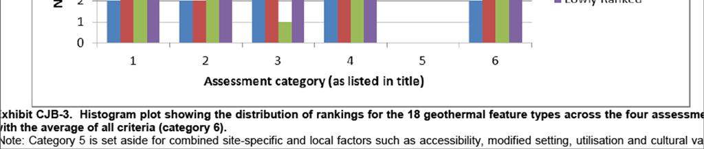
16 Distribution Histogram
17 Risk based approach (impact of proposed activity) Determine severity of consequence Negligible, minor, moderate, severe, major Establish likelihood of loss (feature/habitat) as a result of activity Rare, unlikely, possible, likely, almost certain Relative level of risk = consequence x likelihood Intolerable, tolerable with conditions, tolerable, acceptable


18 Apply Consequence and Likelihood to these fields Get the final score


19 Work out what it all means.


20 Thanks.. Questions Thermal IR image Pohutu and PWF Geysers, Whakarewarewa