2.6 NAM FA HYROPOWER PROJECT
|
|
|
- Robyn Small
- 5 years ago
- Views:
Transcription


1 2.6 NAM FA HYROPOWER PROJECT The Nam Fa Project is located in Bokeo Province on the Nam Fa (Nam Pha). The layout of the Project is shown in the attached plan. The project configuration developed for the PSDP involved a 130 m dam with a 70 MW power station at its base generating electricity from the head created by the dam. The Consultant has evaluated the Project using: Existing field data no new field data was collected; Updated hydrology (1966 to 2002 streamflow series); EVALS hydropower dimensioning and evaluation software; The technical and economic characteristics of the Project are summarized in the following table. With a specific generation cost of 10 /kwh, the Project is not attractive from an economic perspective and in the current market there are better generation alternatives for supplying north-western Lao PDR. No project interactions were assumed in determining these outputs. The EVALS outputs are provided. Some environmental and social costs are accounted for in the EVALS evaluation and are reflected in the program outputs. Power System Development Plan August 2004 Final Report Vol C: Project Catalogue 15
2 Technical and Economic Data (Source: EVALS Output): Development: Installed Capacity Factor 1.75 Contractual status No mandate issued Level of study Inventory Access Roads: New road 10 km Rehabilitation 0 km Hydrology: Name of river Nam Pha Av. annual precipitation (dam site) 2,166 mm/a Ave. Reservoir Inflow 45.2m 3 /s Reservoir: Full supply level (FSL) 530 m asl Minimum operating level (MOL) 515 m asl Max storage volume (FSL) 2330 hm 3 Active storage volume 895 hm 3 Maximum reservoir area (FSL) 71.6 km 2 Reservoir filling time 19.5 months Dam: Main dam type Concrete Faced Maximum height 130 m Crest length 600 m Diversion: Design discharge 1,690 m 3 /s Tunnel Diameter 10.8m Tunnel Length 740 m Spillway: Spillway type Gated Chute Design discharge 2,000 m 3 /s Power Station: Type Surface Number of units 2 Turbine type Francis Turbine rated head 98 m Transmission: Line Length 154 km Voltage 115 kv Output: Installed Capacity 70 MW Guaranteed capacity (95%) Average generation Primary generation (95% firm) Secondary generation 57 MW 295 GWh p.a. 280 GWh p.a. 15 GWh p.a. Average plant factor 47 % Economic: Basic project cost (no esc. or IDC) 237 mus$ Capacity cost Average energy cost Weighted energy cost 5 4,101 US$/kW 10.5 /kwh 10.8 /kwh 5 The calculation of weighted generation cost values secondary energy at half the value of primary energy based on a definition of primary energy as energy produced with 95% firmness. Power System Development Plan August 2004 Final Report Vol C: Project Catalogue 16
3
4
5

6
7 2.7 NAM KONG 1 HYDROPOWER PROJECT The Nam Kong 1 Hydropower Project is located in Attapeu Province on the Nam Kong, a southern tributary of the Se Kong River, in the upland area which forms the south eastern Lao border with Cambodia. The scheme is within 20km of the Lao-Cambodian border and about 30km south and west of the regional capital of Attapu.The location of the Project is shown in the attached plan. Due to its size, location and economics, Nam Kong 1 is envisaged primarily as an export project selling to Vietnam or Cambodia as its principal market No exclusive mandate to develop the site presently exists. The Nam Kong 1 project was identified in the 1995 JICA Se Kong Master Plan Study and was studied by Halcrow to pre-feasibility level in Social and environmental studies of the site have been carried out to IEE standards. The PSDP project configuration involves an 80 m dam and a headrace tunnel to divert stored flows to the powerhouse approximately 3 km downstream where electricity is generated using the head provided by the dam and the steep river gradient between dam and powerhouse. The Consultant has evaluated the Project using: Existing field data no new field data was collected; Updated hydrology (1966 to 2002 streamflow series); EVALS hydropower dimensioning and evaluation software; The technical and economic characteristics of the Project are summarized in the following table. No project interactions were assumed in determining these outputs. The EVALS outputs are provided. Some environmental and social costs are accounted for in the EVALS evaluation and are reflected in the program outputs. Power System Development Plan August 2004 Final Report Vol C: Project Catalogue 17
8 Technical and Economic Data (Source: EVALS Output): Development: Installed Capacity Factor 1.75 Contractual status No mandate issued Level of study Prefeasibility Access Roads: New road 32 km Rehabilitation 0 km Hydrology: Name of river Nam Kong Av. annual precipitation (dam site) 1,944 mm/a Ave. Reservoir Inflow 58.3 m 3 /s Reservoir: Full supply level (FSL) 320 m asl Minimum operating level (MOL) 285 m asl Max storage volume (FSL) 297 hm 3 Active storage volume 271 hm 3 Maximum reservoir area (FSL) 12.1 km 2 Reservoir filling time 1.5 months Dam: Main dam type Concrete Gravity Maximum height 32 m Crest length 160 m Diversion: Design discharge 1,470 m 3 /s Tunnel Diameter 11.6 m Tunnel Length 400 m Spillway: Spillway type Gated Chute Design discharge 2,750 m 3 /s Power Station: Type Surface Number of units 4 Turbine type Francis Turbine rated head 163 m Transmission: Line Length 77 km Voltage 115 kv Output: Installed Capacity 150 MW Guaranteed capacity (95%) Average generation Primary generation (95% firm) Secondary generation 117 MW 626 GWh p.a. 365 GWh p.a. 260 GWh p.a. Average plant factor 46 % Economic: Basic project cost (no esc. or IDC) 202 mus$ Capacity cost Average energy cost Weighted energy cost 6 1,525 US$/kW 4.1 /kwh 5.1 /kwh 6 The calculation of weighted generation cost values secondary energy at half the value of primary energy based on a definition of primary energy as energy produced with 95% firmness. Power System Development Plan August 2004 Final Report Vol C: Project Catalogue 18
9
10
11
12

13
14 2.8 NAM LONG HYDROPOWER PLANT The Nam Long Hydropower Project is located on the Nam Long in Luangnamtha Province. The layout of the Project is shown in the attached plan. It involves the construction of a small dam of about 18 m height and a headrace tunnel that cuts off a loop in the river to divert flows to the powerhouse some 10 km downstream. The head generated by the dam and river gradient is about 470 m. The Consultant evaluated the Project using: Existing field data no new field data was collected; Updated hydrology (1966 to 2002 streamflow series); EVALS hydropower dimensioning and evaluation software; SESAMEE environmental and social impact assessment. Luangnamtha will connect to the Central Grid in 2006 under the ADB Power Transmission Development 2 project. The Project would therefore interconnect with the EdL system through a transmission line to Luangnamtha. The technical and economic characteristics of the Project are summarized in the following table. With a weighted generation cost of 5.5 /kwh, the project is attractive but in the current market it is more expensive than alternative sites in the Central Grid. However, it is ideally located to provide system benefits including voltage support, loss reduction and supply security for the loads in the northern provinces. The EVALS outputs are provided. No project interactions were assumed in determining these outputs. Some environmental and social costs are accounted for in the EVALS evaluation and are reflected in the program outputs. The project s wider impacts have been assessed using SESAMEE and are internalized into the evaluations reported in Section 6 of Volume A, Main Report. A feasibility study of the project is recommended. Power System Development Plan August 2004 Final Report Vol C: Project Catalogue 19
15 Technical and Economic Data (Source: EVALS Output): Development: Installed Capacity Factor Run-of-river Contractual status No mandate issued Level of study Inventory Access Roads: New road 15 km Rehabilitation km Hydrology: Name of river Nam Long Av. annual precipitation (dam site) 1,944 mm/a Ave. Reservoir Inflow 2.9 m 3 /s Reservoir: Full supply level (FSL) 1,010 m asl Minimum operating level (MOL) 1,010 m asl Max storage volume (FSL) 0.37 hm 3 Active storage volume hm 3 Maximum reservoir area (FSL) 0.0 km 2 Reservoir filling time 0.5 months Dam: Main dam type Concrete Gravity Maximum height 18 m Crest length 110 m Diversion: Design discharge m 3 /s Tunnel Diameter 3.0 m Tunnel Length 5,800 m Spillway: Spillway type Ungated Ogee Design discharge 299 m 3 /s Power Station: Type Surface Number of units 2 Turbine type Pelton Turbine rated head 471 m Transmission: Line Length 33 km Voltage 115 kv Output: Installed Capacity MW Guaranteed capacity (95%) Average generation Primary generation (95% firm) Secondary generation MW 63 GWh p.a. 50 GWh p.a. 13 GWh p.a. Average plant factor 60 % Economic: Basic project cost (no esc. or IDC) mus$ Capacity cost Average energy cost Weighted energy cost 7 2,390 US$/kW 5.0 /kwh 5.5 /kwh 7 The calculation of weighted generation cost values secondary energy at half the value of primary energy based on a definition of primary energy as energy produced with 95% firmness. Power System Development Plan August 2004 Final Report Vol C: Project Catalogue 20
16
17
18

19
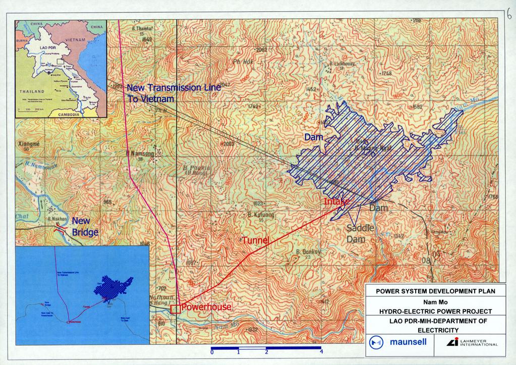
20 2.9 NAM MO HYDROPOWER PROJECT The Nam Mo Hydropower Project is located on the Nam Mo in Xiengkhouang Province. Nam Mo is being promoted as an export project to Vietnam. Its layout is shown in the attached plan. The Project is in the upper headwaters of the Nam Mo, where a dam of about 50 m would create a small reservoir of approximately 11 km 2 and a headrace tunnel would divert flows to a downstream powerhouse taking advantage of the steep river gradient to create more head. Lack of access to data related to downstream social and environmental conditions in Vietnam has limited the evaluation presented here of the implications for Lao PDR. The Project has been studied to feasibility level by its developer. The Consultant evaluated the Project using: Existing field data no new field data was collected; Updated hydrology (1966 to 2002 streamflow series); EVALS hydropower dimensioning and evaluation software; SESAMEE environmental and social impact assessment. The technical and economic characteristics of the Project are excellent. They are summarized in the following table. No project interactions were assumed in determining these outputs. The EVALS outputs are provided. Some environmental and social costs are accounted for in the EVALS evaluation and are reflected in the program outputs. The project s wider impacts have been assessed using SESAMEE and are internalized into the evaluations reported in Section 6 of Volume A, Main Report. Power System Development Plan August 2004 Final Report Vol C: Project Catalogue 21
21 Technical and Economic Data (Source: EVALS Output): Development: Installed Capacity Factor 1.75 Contractual status Concession Level of study Feasibility Access Roads: New road 50 km Rehabilitation 10 km Hydrology: Name of river Nam Mo Av. annual precipitation (dam site) 1,944 mm/a Ave. Reservoir Inflow 10.1 m 3 /s Reservoir: Full supply level (FSL) 1, m asl Minimum operating level (MOL) 1, m asl Max storage volume (FSL) 291 hm 3 Active storage volume 264 hm 3 Maximum reservoir area (FSL) 10.8 km 2 Reservoir filling time 8.5 months Dam: Main dam type Earthfill Maximum height 82 m Crest length m Diversion: Design discharge 1,420 m 3 /s Tunnel Diameter 12.6 m Tunnel Length 680 m Spillway: Spillway type Ungated Ogee Design discharge 2,890 m 3 /s Power Station: Type Surface Number of units 4 Turbine type Pelton Turbine rated head 803 m Transmission: Line Length 44 km Voltage 115 kv Output: Installed Capacity 125 MW Guaranteed capacity (95%) Average generation Primary generation (95% firm) Secondary generation 118 MW 602 GWh p.a. 589 GWh p.a. 12 GWh p.a. Average plant factor 54 % Economic: Basic project cost (no esc. or IDC) 116 mus$ Capacity cost Average energy cost Weighted energy cost 8 1,067 US$/kW 2.4 /kwh 2.4 /kwh 8 The calculation of weighted generation cost values secondary energy at half the value of primary energy based on a definition of primary energy as energy produced with 95% firmness. Power System Development Plan August 2004 Final Report Vol C: Project Catalogue 22
22
23
24
25
26
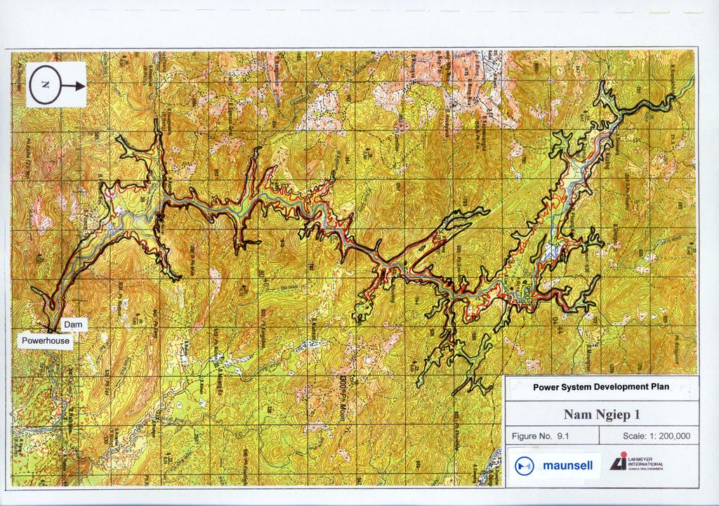
27 2.10 NAM NGIEP 1 HYDROPOWER PROJECT The Nam Ngiep 1 Project is located on the Nam Ngiep in Bolikhamxay Province. The location of the Project is shown in the attached plan. The Project with an ICF of 1.75 involves a main dam of about 150 m height creating a storage and head that is used for generating about 330 MW from a powerhouse located at the base of the dam. The project configuration includes a smaller downstream dam to re-regulate power station discharges. A generator at the re-regulation dam would have an output of about 40 MW. Due to its size, location and economics, Nam Ngiep 1 is well suited for an export role selling to Thailand or Vietnam or for supplying the domestic market. The PSDP system expansion analyses indicate that the optimal installed capacity of the Project for supplying the Central Grid would be about 215 MW. An exclusive mandate was awarded to Japan International Cooperation Agency (JICA) to investigate the site and the studies confirm the promise indicated in earlier studies. The Consultant evaluated the Project using: Existing field data no new field data was collected; Updated hydrology (1966 to 2002 streamflow series); EVALS hydropower dimensioning and evaluation software; SESAMEE environmental and social impact assessment. The technical and economic characteristics of the Project are summarized in the following table. The EVALS outputs are provided. Some environmental and social costs are accounted for in the EVALS evaluation and are reflected in the program outputs. The project s wider impacts have been assessed using SESAMEE and are internalized into the evaluations reported in Section 6 of Volume A, Main Report. No project interactions were assumed in determining these outputs. Power System Development Plan August 2004 Final Report Vol C: Project Catalogue 23
28 Technical and Economic Data (Source: EVALS Output): Development: Installed Capacity Factor 1.75 Contractual status Japanese consortium Level of study Feasibility study Access Roads: New road 0 km Rehabilitation 7 km Hydrology: Name of river Nam Ngiep Av. annual precipitation (dam site) 2,900 mm/a Ave. Reservoir Inflow m 3 /s Reservoir: Full supply level (FSL) 320 m asl Minimum operating level (MOL) 296 m asl Max storage volume (FSL) 2,250 hm 3 Active storage volume 1,190 hm 3 Maximum reservoir area (FSL) 66.9 km 2 Reservoir filling time 2.9 months Dam: Main dam type Concrete Faced Rockfill Maximum height 148 m Crest length 490 m Diversion: Design discharge 2,330 m 3 /s (main dam only) Tunnel Diameter 2 trnnels-11.2m ea Tunnel Length 1,100 m Spillway: Spillway type Gated chute (main dam only) Design discharge 4,830 m 3 /s Power Station: Type Surface/surface (Reg dam Number of units 2/2 in brackets) Turbine type Francis/Kaplan Turbine rated head 127m (16m) Transmission: Line Length 137 km Voltage 230 kv Output: Installed Capacity (inc re-reg dam) 330 MW (40 MW) Guaranteed capacity (95%) 258 MW (39 MW) (Reg dam Average generation 1,362 (174) GWh p.a. in brackets) Primary generation (95% firm) 1,031 (127) GWh p.a. Secondary generation 331 (46) GWh p.a. Average plant factor 47% (50%) Economic: Basic project cost (no esc. or IDC) 59.6 mus$ Capacity cost US$/kW (Reg dam Average energy cost 3.3 (4.1) /kwh in brackets) Weighted energy cost (4.7) /kwh 9 The calculation of weighted generation cost values secondary energy at half the value of primary energy based on a definition of primary energy as energy produced with 95% firmness. Power System Development Plan August 2004 Final Report Vol C: Project Catalogue 24
29
30
31
32
33
34
35