Draft Official Plan presented to Committee of the Whole on November 24, 2017 Held an information session with local municipal staff and agency staff
|
|
|
- Oswin King
- 5 years ago
- Views:
Transcription


1
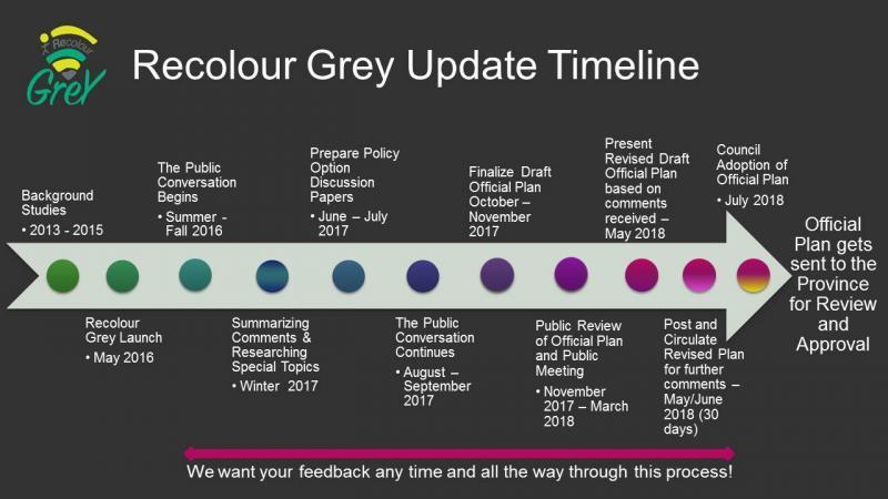
2 Draft Official Plan presented to Committee of the Whole on November 24, 2017 Held an information session with local municipal staff and agency staff at the beginning of November to highlight the proposed policy and mapping changes Posted the draft official plan on County website and circulated to extensive contact list We have met with local municipal planners, conservation authorities, NEC staff, developers, consultants, the Federation of Agriculture, and any members of the public interested in meeting with us directly We have also met with the Province and Saugeen Ojibway Nation Four Open Houses held week of March 12 th, 2018 Council/Local Council Workshop held on March 16 th, 2018 Presented an Overview of Comments Received to Date to Committee of the Whole March 22, 2018 Public Meeting March 27, 2018 Posted all comments received on website and shared with Council
3 We plan for people, whether they be community members or visitors Land use planning affects almost every area of life It helps set goals about how our communities should grow and develop while balancing social, economic and environmental interests Balances the interests of individual property owners with the wider interests and objectives of the entire community and the Province. Good planning leads to healthy orderly growth, promotes community interaction, happiness and social equity, supports the economy This draft Official Plan should be read as a plan for people. Critical elements of this Plan - Creating healthy communities, enhancing quality of life, fostering a strong local economy, preserving our environment and resource lands, encouraging social interaction, and providing efficient transportation networks The Plan is a guiding document for directing growth for the next 20 years The new Official Plan will change over time through amendments to the Plan, as the needs and interests of the community change.
4 Old Sections (November 2017 Draft) New Sections (May 2018 Draft) 1. Introduction 1. Introduction 2. Managing Our Growth 2. Managing our Growth 3. Cultivate Grey 3. Develop Grey 4. Develop Grey 4. Live Grey 5. Niagara Escarpment Plan 5. Cultivate Grey 6. Natural Grey 6. Niagara Escarpment Plan 7. Live Grey 7. Natural Grey 8. Move Grey 8. Move Grey 9. Our Tools 9. Our Tools 10. and 11. Secondary Plans 10. and 11. Secondary Plans

5 Added further wording on why we plan and the importance of good land use planning Made the following revisions to the Our Opportunities section including; Added a section about supporting young families, youth and newcomers, Revised the Economic Changes section, Added a Complete Communities section, Added some language about the importance of culture in subsection 10, and Added a Tourism and Recreation section given the importance of Tourism and Recreation in Grey.

6 Revised the growth projection tables using the latest growth projection numbers from Hemson Consulting and based on the comments received from local municipalities and others. Added in clarification on the differences between various growth projections from different sources. Added a statement indicating that the County will work with our local municipalities and community partners in developing a common set of growth projections that we can all utilize.
7 General Policies Affecting Settlement Area Land Use Types efforts for development intensification are encouraged prior to considering a comprehensive review, and/or municipal boundary restructuring (Section 3.4). Settlement Area Expansions upon receiving guidance from the Province, further policy direction was provided that speaks to the notion of reinstating previously designated settlement area lands that were either removed or redefined in the previous Official Plan update. Consideration for this type of development will only be assessed upon completion of a scoped comprehensive review (Section 3.4.2).
8 Municipal boundary restructuring (annexation) based on comments from municipalities in Grey experiencing restricted settlement area boundaries, a new section was included that begins to define the process of a municipal boundary adjustment as per regulations from the Municipal Act and Planning Act. Second Units included policy clarity for second unit development and as-of-right permissions within settlement areas. Inland Lakes and Shoreline Areas additional wording was included that speaks to conservation efforts along the County s shorelines.
 adjusted the definition of affordable housing to better encompass the broader meaning,")
9 Accessibility for Ontarians with Disabilities Act (AODA) compliance included wording that recognizes the need to make heritage properties accessible, while ensuring alterations do not adversely affect the heritage attributes Affordable Housing The Housing Continuum (Canadian Mortgage Housing Corporation) adjusted the definition of affordable housing to better encompass the broader meaning, which includes all forms of housing tenure (i.e. rental, ownership and cooperative ownership). It can also include temporary as well as permanent housing.
10 Inclusionary zoning updated as per Planning Act changes that includes direction for local municipalities to consider incorporating inclusionary zoning through their zoning bylaws. Housing First policy we have adjusted the Housing First policy to now include parameters where priority on the sale of surplus County and municipally owned lands should be given to public, non-profit, and private entities that can demonstrate their ability to provide affordable housing. Evaluation of a successful applicant will be assessed based on design, form of development, tenure, and management.
11 Clarified terminology based on comments received; Defined the terms non-agricultural use, livestock facilities, livestock barns, and home rural occupations (versus home occupations in settlement areas), Farm size and non-farm sizes are defined for the countryside land use types, Minimum Distance Separation (MDS) formulae now applies to all lots created after March 1, 2017, as per the Provincial MDS Guidelines, Clarified provisions around medical marihuana / cannabis production locations, Clarified servicing requirements in Agricultural, Special Agricultural, Rural, Clarified the policies restricting non-farm sized lot development within 500 metres of a Primary Settlement Area, Clarified the policies restricting non-farm development adjacent to Mineral Resource Extraction sites, or within the Aggregate Resource Areas, Clarified the surplus farm dwelling severance policies to require the farm lands to either be (i) owned by, or (ii) being sold to a bona fide farmer, Added in the policy permitting agricultural-related use severances, Deleted the policy permitting inns and motels in the Rural land use type.
12 On-Farm Diversified Uses a new Table 8 has been added to the Plan with size criteria for on-farm diversified uses. This criteria is based on the Province s Permitted Uses In Prime Agricultural Areas Guideline. This policy change eliminates the term small scale from the definition, and instead utilizes a size criteria which is relative to the size of the property, and considers the entire use (i.e. buildings, laneways, parking, outdoor storage, servicing, exhibition areas, and/or amenity areas occupied by the on-farm diversified uses), not just the total building size. The total building size of an on-farm diversified uses can occupy no more than 20% of the total size of the use itself (i.e. 20% of the 2% of property size, or 8,000 square metres could be buildings on a farm-sized parcel). The size of an on-farm diversified use is still distinguished from the farm and residential uses on the property i.e. farm buildings, driveways, and houses are not included in the size requirement calculations for an onfarm diversified use.
13 Table 8: On-farm Diversified Use Size Criteria Land use type Property Size On-farm diversified Use Maximum Size The lesser of; 2% of the total size of the property, or 20 hectares or greater a maximum combined area of the use of Agricultural 8,000 square metres Less than 20 hectares Bed and breakfasts and/or home rural occupations within the dwelling only. The lesser of; Special Agricultural Rural 10 hectares of agriculturally productive area or greater Less than 10 hectares of agriculturally productive area 20 hectares or greater Less than 20 hectares 2% of the total size of the property, or a maximum combined area of the use of 8,000 square metres Bed and breakfasts and/or home rural occupations within the dwelling only. The lesser of; 2% of the total size of the property, or a maximum combined area of the use of 8,000 square metres The lesser of; 2% of the total size of the property, or a maximum combined area of the use of
14 Resource Based Recreational Uses added some new criteria for consideration of resource based recreational uses, as well as residential development associated with such uses. Added in the site specific exceptions for approved Official Plan Amendments. Bedrock and Shale Resource Areas based on comments from the Province, added a new section dealing with Bedrock and Shale Resource Areas, shown on Appendix E. The resource areas are mapped for information purposes only at this stage. Required studies for pit/quarry operations added policies in section 5.6.4(4) to require rehabilitation plans and agricultural impact assessments (in the Agricultural or Special Agricultural land use types) for pit and quarry operations. Oil and Gas Resources added a new section 5.8 to the Plan, as well as additional mapping on Appendix A showing oil and gas resources. Based on this being a new policy area in the County, staff utilized official plan policies from the recent County of Lambton Official Plan, where they have more knowledge on this subject matter. A policy has also been included here noting that fracking is not a permitted use, based on public comments and based on Council s previous position with respect to fracking.
15 Niagara Escarpment Plan added in a policy recognizing Georgian Bluffs current deferral for urban uses on the airport lands, which was submitted as part of the Provincial Coordinated Land Use Plan review (and deferred in the Province s decision on the Niagara Escarpment Plan). Niagara Escarpment Plan clarified the Hazard Lands policies within the Niagara Escarpment Plan Area. Clarified the permitted uses in Core Areas and Linkages as per a new Table 10 (see next slide). Refined Linkage mapping slightly to follow natural corridors, where possible, based on concerns from landowners and local knowledge. Clarified that neither the Core Areas nor Linkages are intended to become public lands or public trails, where the land is not already in public ownership.
16 Permitted Use Core Areas Core Areas Adjacent lands Linkages EIS Required* Agricultural uses including new buildings / structures Yes Yes Yes No Agricultural-related uses incl. new buildings / structures No Yes Yes Maybe Home rural occupations within existing buildings Yes Yes Yes No On-farm diversified uses incl. new buildings / structures No Yes Yes Maybe Conservation and flood control projects Yes Yes Yes No Forest, fish and wildlife management Yes Yes Yes No Transportation, utility, service corridors as per Section 8 Yes Yes Yes Maybe Compatible recreation Yes Yes Yes Maybe Good forestry management as defined in the County s Forest Management By-law Yes Yes Yes No Existing uses, buildings and structures, or minor expansions thereto Yes Yes Yes No Reuse of existing building and structures, provided the reuse will not have additional environmental impacts Yes Yes Yes No Existing mineral aggregate extraction operations Yes Yes Yes No Expanded mineral aggregate extraction operations Yes Yes Yes Yes New mineral aggregate extraction operations No Yes Yes Yes New dwellings / accessory uses on lots of record Yes Yes Yes No
17 Added a new policy in section 7 recognizing existing approved and draft approved developments, and exempting them from further environmental review, except where required by Provincial / Federal Regulations, or where major changes are being proposed to a development. Parkland added some additional policies to section 7.12 recognizing the importance of parks (including dog parks, skate parks and trampoline parks), in response to numerous public comments. Climate Change based on comments from a number of parties, revised the Climate Change policies in section 7.13 of the Plan. Karst Area Policies and Mapping updated the karst area policies and mapping.
18 Clarified terminology and mapping as follows; Provincially Significant Wetlands now also include Significant Coastal Wetlands, Areas of Natural and Scientific Interest are now referred to as Significant Areas of Natural and Scientific Interest, The adjacent lands buffer for Fish Habitat has been increased to 120 metres, as per the Natural Heritage Reference Manual 2010, Buffer is used when referring to adjacent lands, rather than setback, Hazard Forest Types for Wildland Fire are now mapped on Appendix A, Clarified terminology around Significant Wildlife Habitat and Habitat of Threatened / Endangered Species, Environmental Impact Studies added in a policy under section noting that the County, in cooperation with member municipalities and Conservation Authorities may develop an environmental impact study guideline to include a terms of reference and more detail on scoped environmental impact studies, Added in some wording in sections 5.5 (Forestry Uses) and 7.4 (Significant Woodlands) recognizing plantations versus more naturalized woodland features.
19 Added some policies in the General Transportation section regarding historic transportation routes, screening outdoor storage areas and loading areas that back onto provincial highways, stormwater management/drainage requirements, and ensuring that development adjacent to patrol yards is compatible. Added in language to clarify the differences between Provincial Connecting Links and the Connecting Links being proposed on County Roads. Added in policies encouraging local municipalities to improve pedestrian safety within Provincial Highway Connecting Links through the use of such measures as traffic calming, roundabouts, improved signage, etc. Identified Concession 5 Derby and Concession 6 (Sullivan) that connects Grey Road 40 to Grey Road 18 as a Potential Planned County Road corridor. Identified the recommended functional classification of these planned corridors should they become County Roads in the future.
20 Included a statement indicating that options for a by-pass at the south end of Markdale be explored and have identified this graphically on Appendix D. The functional classification of Grey Road 9 has been changed to County Arterial based on comments from the Township of Southgate and through further discussions with County Transportation Services. Added policies regarding living snow fences Added further policies and criteria for when to consider development on existing lots of record that gain access from a private road or a seasonally maintained road Clarified the wording with respect to the policy dealing with new development adjacent to the CP Rail Trail when considering the potential return of rail service such that new development be designed to include buffers/setbacks and screening (i.e. fences, berms, tree plantings, landscaping, etc.) to the satisfaction of the County.
21 Clarified some of the servicing policies based on comments received including; What is meant by interim servicing measures (Section 8.9.1(7)), Clarifying the intent of infilling and rounding out on partial services (Section 8.9.1(10)), Encouraging local municipalities to develop a servicing strategy for partially serviced settlement areas to provide the other municipal service (Section 8.9.1(11)), and Clarifying that when service partnerships are not possible or are not working for municipalities then municipalities may need to explore other options including municipal boundary restructuring (e.g. annexation) Section 8.9.1(14). Mapped wastewater/sewage treatment facilities on Appendix A and have included a policy re: buffer separation
22 Added some policy language in the Managing our Waste section regarding working towards a circular economy and indicating that the County and the local municipalities will consider implementing the Food and Organic Waste Policy Statement Updated some of the Source Protection Policies based on comments from the Province and from local source protection authorities Clarified that the commercial water taking policies apply to new commercial water taking operations from a non-municipal water service intended for human consumption.
23 Similar to Section 6 in the current official plan Provides information about: Understanding the Plan (Interpreting) Holding Symbols Following the Plan (Conformity) Site Plan Control Making Changes to the Plan (Amendments) General Lot Creation Policies Monitoring the Plan Plans of Subdivision/Condo Considerations Overview of Planning and Development Process Development Charges Information about Zoning Maintenance and Occupancy Standards Information about Committee of Adjustment and Consents Community Improvement Plans Explaining non-conforming uses Complete Application Considerations Temporary Use By-laws Definitions
24 Added some wording in the Understanding the Plan section about the Niagara Escarpment Plan. Clarified terminology throughout the Plan with respect to words such as will, must, should and encourage. Added some further studies that could be considered as part of a complete application and clarified that the information/study requirements will be determined at the time of pre-submission consultation. Clarified and added some definitions in Section 9.18
25 Updated Hazard Land mapping including two-zone mapping in Neustadt and Durham Petroleum Wells have been identified on Appendix A. Wellhead Protection Areas in the Dundalk area have been updated Karst Area mapping has been updated based on new mapping from the Province. Wildland Fire Forest mapping has been added on Appendix A based on mapping from the Province. Wastewater Treatment Facilities (i.e. sewage treatment facilities) have been added on Appendix A. Reverted back to the Other Identified Wetland mapping in the current Official Plan and have called it Other Wetlands. Significant Woodland mapping has been revised further in the Town of The Blue Mountains to be consistent with the Town OP mapping Provincial Highway Connecting Links has been identified in Appendix D. Bedrock and Shale Resource Areas have been identified in Appendix E The Aggregate Resources Area mapping has been updated on Schedule B by removing areas that overlap with the Core Areas on Schedule C.
26 May/June post Official Plan and circulate for any final comments (30 day review period) July summarize any further comments received and present a final version of the Official Plan to County Council for adoption. Send the Plan onto the Province for their review and approval following Council s adoption of the Plan.

27


28 Comments / Questions Stay connected with Recolour Grey as the process continues. Check our website regularly at on Twitter, and like Recolour Grey on Facebook.