Scottish Hydrological Group Meeting, 13 th November Surface water management plans in action Case studies in Kent.
|
|
|
- Albert Warren Carroll
- 5 years ago
- Views:
Transcription


1 Scottish Hydrological Group Meeting, 13 th November Surface water management plans in action Case studies in Kent Paul Eccleston
2 Topics Prioritisation and broad-scale surface water mapping Case study 1: Canterbury Detailed modelling and optioneering Case study 2: Folkestone Communications and engagement Development and SWMPs Case study 3: Paddock Wood 2


3 PRIORITISATION AND BROAD-SCALE SURFACE WATER RISK MAPPING
4 Do we need a SWMP? Is there a history of surface water flooding? Is there a significant modelled risk? Is the co-operation of two or more Risk Management Authorities required to resolve the problem? Is there significant future development / redevelopment potential? Approach in Kent Stage 1 Partnership building, screening, national mapping Stage 2 detailed modelling, options
5 Broad-scale surface water risk mapping EA about to release 3rd generation of national scale surface water flood mapping Most work (SWMPs, PFRAs) has used 2 nd Generation Flood Map for Surface Water. National scale surface water flood mapping (England and Wales) + Locally produced surface water flood modelling + Locally updated confidence scores = Updated Flood Map for Surface Water (ufmfsw) 5

6 UFMfSW modelling in brief Undertaken on a 2m resolution using the JFlow+ 2D hydraulic model DTM combination of best available (LiDAR + NextMap) Direct rainfall approach with land use based runoff coefficients and some local input on urban drainage capacities. Scenarios: 1 in 30, 1 in 100 and 1 in 1,000 rainfall Local review / verification by councils, water companies etc. 6
7 Broad-scale mapping application in SWMPs FMfSW has driven some more detailed investigations where high modelled risk does not match flood history. e.g. Canterbury Presence of a risk map should challenge our thinking of flood risk but it is not the complete picture. UFMfSW generally well received by councils and water companies, but system also allows local updating of results with more detailed models. First time that surface water mapping will be generally available to the public. Will future effort be further (top-down) country-scale mapping or (bottom-up) detailing by LLFAs? 7
8 Case study 1: Canterbury Preliminary Flood Risk Assessment (PFRA) concluded that Canterbury formed a significant cluster of predicted flood risk In England there are 219 clusters. Canterbury ranked: 50 out of 219 in terms of people at flood risk 1 out of 219 in terms of scheduled monuments at flood risk 13 out of 219 in terms of listed buildings at flood risk But little historic evidence of a major problem... Integrated fluvial / surface water modelling undertaken to provide a higher-confidence assessment of risk. 8

9 FMfSW 9

10 ufmfsw 100 year 10

11 Maximum Flood Depth M City centre - risk kept low by extensive surface water sewerage system Modelled risk confirmed by historic reports Contains Ordnance Survey data. Crown copyright and database right
12 DETAILED MODELLING AND OPTIONS

13 Case study 2: Folkestone Combined and separate sewerage scheme Extensive culverting following 1996 floods Channel Tunnel Terminal works enhanced drainage Drains via 4 tributaries of the Pent Stream to the Sea Contains Bing Maps data. Copyright right
 Prioritises the foul and combined network, some SW sewers modelled EA river model")

14 Developing the integrated urban drainage model + + Southern Water Sewerage model (InfoWorks CS) Prioritises the foul and combined network, some SW sewers modelled EA river model (ISIS-TUFLOW). Multiple culverts and small weirs New 2D surface model Detailing of buildings, kerblines, key walls. Contains Ordnance Survey data. Crown copyright and database right


15 Hydrology + + Upstream catchments re-use ReFH model from the fluvial modelling. Sewer subcatchments using Wallingford Procedure PR. Some overlapping foul and surface subcatchments. Direct rainfall modelling and fixed PR infiltration zones Great care needed to ensure 100% of catchment surface is represented.

16 Sub-catchment based modelling

17 Local detailing a model of runoff surfaces

18 18

19 Developing options SUDs retro-fit for large car parks Storage ponds within allotments to attenuate and irrigate. Connection to Pent D Connection to deep sewer Highways interventions permeable / rain gardens / kerbing
20 COMMUNICATIONS AND ENGAGEMENT
21 Building the partnership what works Frequent meetings including site tours Consistency of staff across SWMPs Data sharing agreements Active participation in steering and reviewing the SWMP. Review the partnership and if necessary expand
22 Communications and Engagement Plan Enables forward planning Sets out business and communication aims and objectives Helps avoid working backwards in communication terms i.e. reacting when a problem arises Is an industry standard Defra preferred method Provides an evidence base for communications and engagement planning and thinking. Not just an add-on to the technical work! 22
23 Working with stakeholders the process Who are the stakeholders and why? Mapping of stakeholders 'Impact' and 'Influence' Rationale for engagement When should they be involved and why? Establish stakeholder importance Indicate degree of engagement How should we engage? Direct meetings Open / by-invitation events Local media / websites 23
24 Why? Potential Benefits Can arrive at better solutions Helps to reduce conflict Audience up-skilling Builds relationships state /public Can help avoid delay Evidence base - demonstrates responsiveness in case of challenge/legal action Legal requirements? Mainly regulatory Best Value Statutory Guidance (2011) Localism Act (2011) Aarhus Convention (1998, in force 2001) Water Framework Directive (WFD) (2000) EU/UK inclusivity legislation 2010
25 Who? Generic potential stakeholders in no particular order of importance Individual residents Local communities (e.g. residents associations) Vulnerable receptors (e.g. old people s homes, schools, caravan sites, hospitals) Minority/seldom heard from groups (e.g. faith, immigrants, refugees/asylum seekers/ young, old, those with disabilities) The wider public aim to include both men and women as views do not always converge Regional/local authorities and their numerous departments (other than your own authority) Elected members (local, regional, national) Government agencies and bodies Statutory stakeholders (Natural England, the Environment Agency, English Heritage) Internal stakeholders - teams and departments within your authority, perhaps the Group itself? Transport operators and authorities (e.g. TfL) Local historic societies/heritage groups Local environmental groups Responsible bodies (e.g. fishing/river authorities/utilities) Influential bodies/ ginger groups not covered by Statutory consultees or similar (e.g. National Flood Forum, regional committees, port authorities) Emergency services Businesses individually and collectively Farmers/landowners/riparian owners/reservoir undertakers Insurers/Insurer representative bodies. Developers All those who choose to take an interest (Aarhus Convention rights) The media
26 When? What will they contribute? How will they be affected + when do they need to know? Throughout the project or at key points? What are the consequences (risks) of not involving them in a timely way?
27 SWMPS AND DEVELOPMENT
28 Major changes since SWMPs began... Localism Act (2011) National Planning Policy Framework (2012) Presumption in Favour of Sustainable Development Shift to local decision-making with increased input from people and communities Housing development central to government growth strategy Changes in Flood Defence Grant in Aid (FDGiA): Shift from all-or-nothing national funding to mixed national / local funding Increased role for co-funding from businesses, developers. 28
29 Case study 3: Paddock Wood SWMP was initiated by planners to support their selection of housing sites. Widely held view that development would increase flood risk. 29

30 30
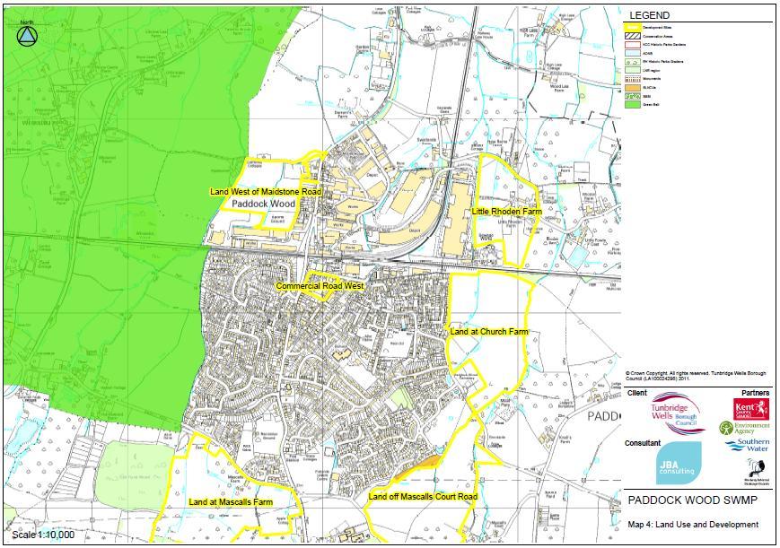
31 31

32 Developing the partnership Two-tier local government Internal Drainage Board Town Council invited to partnership meetings. Previous development had left Town Council with storage ponds to manage Town Council provided trusted link to local community 32


33 Public information event We provided a tour around three key themes, with sticky dot interactive exercises. Invitation event for partners followed by public event. Interaction increases positive input and reduces conflict 200 attendees

34 34
35 What did they say? Inputs confirmed the problem areas identified Gave new information including photographic evidence Broadly supportive of interventions Recognition that surface water management starts at home Two distinct camps: 1. No development at all existing flooding is the reason; 2. (The greater of the two) - Any development must have a transparent and effective plan to minimise the likelihood flooding and reduce impacts on others
36 The Action Plan Quick wins railway drainage, Town Council managed ponds Good SWMP provided connections and momentum to address these Developments should seek to reduce down-stream flood risk OK Evidenced in outline planning applications, but flooding and development remain critical issues for public. Options / capital investment Limited remaining uncertainties around SUDs adoption Funding issues / multiple benefits whose money, whose benefit? 36
37 Summary key progress and barriers Key progress in surface water management Data sharing between partners National modelling Developments in integrated modelling Capacity building stages 1-3 becoming normalised amongst many key partners Key barriers to be addressed Organisational structures Funding SUDs / SUDS Approval Boards Appetite for change (particularly where development isn t significant) 37