Waters of the U.S. and Wetlands
|
|
|
- Berenice Warren
- 5 years ago
- Views:
Transcription

, including wetlands.")
1 Waters of the U.S. and Wetlands Jenny Blair, CWB Senior Environmental Scientist Overview Regulatory background What are Waters of the U.S.? What are Wetlands? What is regulated and how? What does all of this mean for ALTA/NSPS Land Title Surveys? Regulatory Background Clean Water Act Section 404 Section 404 of the Clean Water Act (CWA) establishes a program to regulate the discharge of dredged or fill material into Waters of the United States (WOUS), including wetlands. Activities in WOUS regulated under the CWA include: Fill for development Water resource projects (such as dams and levees) Infrastructure development (such as highways and airports) Mining 1


2 RESERVOIRS TRANSPORTATION PIPELINES 2


3 URBAN INFRASTRUCTURE UTILITY CONSTRUCTION RENEWABLE ENERGY 3


4 RESIDENTIAL & COMMERCIAL DEVELOPMENT Regulatory Background Clean Water Act Section 404 Wetlands and Waters of the U.S. are regulated by the United States Army Corps of Engineers. Regulations change periodically so it is very important to stay up to date. What are Waters of the U.S.? 1. All waters which are currently used, or were used in the past, or may be susceptible to use in interstate or foreign commerce, including all waters which are subject to the ebb and flow of the tide; 2. All interstate waters including interstate wetlands; 4
, mudflats, sandflats, or natural ponds, the use, degradation or destruction of which could affect")


5 What are Waters of the U.S.? 3. All other waters such as intrastate lakes, rivers, streams (including intermittent streams), mudflats, sandflats, or natural ponds, the use, degradation or destruction of which could affect interstate or foreign commerce including any such waters: 1. Which are or could be used by interstate or foreign travelers for recreational or other purposes; or 2. From which fish or shellfish are or could be taken and sold in interstate or foreign commerce; or 3. Which are used or could be used for industrial purposes by industries in interstate commerce; What are Waters of the U.S.? 4. All impoundments of waters otherwise defined as waters of the United States under this definition; 5. Tributaries of waters identified above; 6. The territorial sea; 7. Wetlands adjacent to waters (other than waters that are themselves wetlands) identified above. Streams 3 types of streams: Perennial Stream Continuous flow all year during years of normal rainfall Gaining system Solid blue lines on a topo map Intermittent Stream Flowing water periods are seasonal; i.e. during the wet season Gaining or losing system Dashed blue lines on a topo map Ephemeral Stream Flowing water for brief periods in response to rainfall, above the water table Losing system Dashed blue lines or unidentified on a topo map 5


6 Perennial Stream Continuous flow all year during years of normal rainfall Gaining system Solid blue lines on a topo map Perennial Stream Perennial Stream These streams provide habitats for unique species such as the Barton Creek Salamander 6


7 Intermittent Stream Intermittent Stream Intermittent Stream Flowing water periods are seasonal; i.e. during the wet season Gaining or losing system Dashed blue lines on a topo map 7


8 Ephemeral Stream Ephemeral Stream Ephemeral Stream Flowing water for brief periods in response to rainfall, above the water table Losing system Dashed blue lines or unidentified on a topo map 8

9 Other types of Waters of the U.S. Spring Vernal Pool 9


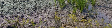
10 Playa Lake Saltflat Mudflat 10


11 Lakes Natural Ponds Wetlands 11
: that line on the shore established by the fluctuations of water and indicated by physical characteristics such as a clean, natural line impressed on the bank,")
12 Wetlands Waters of the U.S. Ordinary High Water Mark (OHWM): that line on the shore established by the fluctuations of water and indicated by physical characteristics such as a clean, natural line impressed on the bank, shelving, changes in the character of soil, destruction of terrestrial vegetation, the presence of litter and debris, or other appropriate means that consider the characteristics of the surrounding areas. Federal Regulations 33 CFR 328.3(e) Waters of the U.S. Ordinary High Water Mark (OHWM) Indicators: Natural line on bank Shelving Changes in soils Destruction of terrestrial vegetation Litter and debris Wracking Vegetation matted, bent, or absent Sediment sorting Litter disturbed, washed away Scour Deposition Multiple observed flow events Bed and banks Water staining Changed plant community 12


13 Water Staining Water Staining and Deposition Water Staining 13


14 Bed and Banks Debris Line Debris Line 14


15 Soil Staining Wrack Line Scour 15


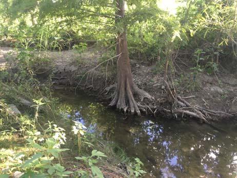
16 Leaning/Matted Vegetation Exposed Roots Exposed Roots 16


17 Clear Line on Bank Deposition and Sediment Sorting Deposition 17

 Documentation Ordinary High Water Mark Stream")
18 Sediment Sorting Waters of the U.S. Ordinary High Water Mark (OHWM): Generally rely on physical evidence Can use gage data, flood predictions, historical records and statistical evidence when physical evidence is inconclusive, misleading, or unreliable Generally use more than one indicator Use characteristics that indicate regular and frequent event (not a 200 year event) Documentation Ordinary High Water Mark Stream Bottom 18


19 Waters of the U.S. Ordinary High Water Mark (OHWM) vs. Extreme High Water Mark: Extreme High Water Mark There is no OHWM present along this drainage! 19
20 What is a Wetland? Merriam Webster Dictionary Definition: Land or areas (such as marshes or swamps) that are covered often intermittently with shallow water or have soil saturated with moisture. What is a Wetland? United States Code (16 U.S.C, Section 3801(a)(18)) Definition: A land that (A) has a predominance of hydric soils, (B) is inundated or saturated by surface or groundwater at a frequency and duration sufficient to support a prevalence of hydrophytic vegetation typically adapted for life in saturated soil conditions and (C) under normal circumstances* supports a prevalence of such vegetation. *Normal circumstances are conditions expected to occur during the wet portion of the growing season under normal climactic conditions (not unusually dry or unusually wet), and in the absence of significant disturbance. What is a Wetland? United States Army Corps of Engineers Definition: Those areas that are inundated or saturated by surface or groundwater at a frequency and duration sufficient to support and that under normal circumstances do support, a prevalence of vegetation typically adapted for life in saturated soil conditions. Wetlands generally include swamps, marshes, bogs, and similar areas. Section 404 of the Clean Water Act 3 Parameters for Classifying Wetlands: Inundated or saturated soil resulting from permanent or periodic ground or surface water Prevalence of vegetation typically adapted for life in saturated soils Presence of normal circumstances ; i.e. presence of hydrology Wetlands are waters but not all waters are wetlands 20
21 Wetlands Three parameters: 1. Soils 2. Vegetation 3. Hydrology Hydrology Is there water for 14 consecutive days or more in a year? Determined from data or secondary visual indicators Hydric Soils Are there hydric soils present? Hydric soils are saturated sufficiently to have anaerobic conditions Visual indicators (Munsell chart) Hydric Soils Lists Field Indicators of Hydric Soils in the United States Source: Wetland Training Institute 21
22 Hydrophytic Vegetation Is there a predominance of wet tolerant plant species present? Species classified in National Wetland Plant lists, Supplements, and text books Wetland Regions 1987 U.S. Army Corps of Engineers Wetland Delineation Manual illustrates 9 different wetland regions and their respective Supplement Manuals Source: USACE Wetlands Great Plains Regional Supplement is what is used for most of Texas Source: USACE 22
23 Source: National Wetlands Inventory Source: National Wetlands Inventory Source: National Wetlands Inventory 23


24 Three Common Wetland Types Forested Wetland Includes all tidal and nontidal wetlands dominated by woody vegetation greater than or equal to 5 meters in height, and all such wetlands that occur in tidal areas in which salinity due to ocean derived salts is below 0.5 percent. Total vegetation coverage is greater than 20 percent. Emergent Wetland (Persistent) Includes all tidal and nontidal wetlands dominated by persistent emergent vascular plants, emergent mosses or lichens, and all such wetlands that occur in tidal areas in which salinity due to ocean derived salts is below 0.5 percent. Plants generally remain standing until the next growing season. Total vegetation cover is greater than 80 percent. Scrub Shrub Wetland Includes all tidal and nontidal wetlands dominated by woody vegetation less than 5 meters in height, and all such wetlands that occur in tidal areas in which salinity due to ocean derived salts is below 0.5 percent. Total vegetation coverage is greater than 20 percent. The species present could be true shrubs, young trees and shrubs, or trees that are small or stunted due to environmental conditions. Forested Wetland Includes all tidal and nontidal wetlands dominated by woody vegetation greater than or equal to 5 meters in height, and all such wetlands that occur in tidal areas in which salinity due to ocean derived salts is below 0.5 percent. Total vegetation coverage is greater than 20 percent. Emergent Wetland Includes all tidal and nontidal wetlands dominated by persistent emergent vascular plants, emergent mosses or lichens, and all such wetlands that occur in tidal areas in which salinity due to ocean derived salts is below 0.5 percent. Plants generally remain standing until the next growing season. Total vegetation cover is greater than 80 percent. 24


25 Scrub Shrub Wetland Includes all tidal and nontidal wetlands dominated by woody vegetation less than 5 meters in height, and all such wetlands that occur in tidal areas in which salinity due to ocean derived salts is below 0.5 percent. Total vegetation coverage is greater than 20 percent. The species present could be true shrubs, young trees and shrubs, or trees that are small or stunted due to environmental conditions. Hydrology of Wetlands Six types of wetland hydrology: Surface Water Depression Wetland Surface Water Flatland Wetland Surface Water Slope Wetland Ground Water Depression Wetland Ground Water Slope Wetland Surface Water Depression Wetland Form in topographical depressions which may be a lowland area Water table does not contribute water to the wetland Input sources are precipitation and runoff The impermeable layer is usually clay Evapotranspiration 25

26 Surface Water Flatland Wetland Groundwater comes from a perched water table, which is formed when a subsurface confining layer separates the top layer from the regional water table Main water sources are groundwater and precipitation Evapotranspiration Surface Water Slope Wetland Receive water primarily from the flooding of lakes or rivers Water can readily drain back into lakes or river as the surface water stages decline Usually areas of regional or local groundwater discharge Evapotranspiration Groundwater Depression Wetland Form in topographical depressions which may be a lowland area Groundwater is the dominant source of water Water table is above the ground surface Evapotranspiration 26
 Surface runoff and precipitation are also sources of water Associated")

27 Groundwater Slope Wetland Groundwater discharges along a hillslope as a seep or spring is the primary source of water (groundwater seepage face) Surface runoff and precipitation are also sources of water Associated with perched water tables that may be adjacent to the wetland Evapotranspiration Available Resources National Wetlands Inventory Nation Hydrography Dataset Aerial Imagery USGS Topographic Maps National Wetlands Inventory 27


28 National Hydrography Dataset Aerial Imagery Topographic Maps 28
 on bank Stream and Wetland Limits Application of written criteria subjective in the field Limits not always clear Bottom line limits of waters")

29 Stream Definitions Up stream limits defined by field conditions and Supreme Court case guidance Rulemaking to clarify waters of the U.S. under way now Primary federal stream rule field stream indicator is defined by Ordinary High Water Mark (OHWM) on bank Stream and Wetland Limits Application of written criteria subjective in the field Limits not always clear Bottom line limits of waters including wetlands often determined via concurrence and collaboration process with USACE and your consultants through preparation of a Jurisdictional Determination What isn t (or should not be) Considered a Waters of the U.S.? Wet areas that are not tributaries or open waters and do not meet the agencies' regulatory definition of "wetlands Waters excluded from coverage under the CWA by existing regulations Waters that lack a "significant nexus" where one is required for a water to be protected by the CWA Artificially irrigated areas that would revert to upland should irrigation cease Artificial lakes or ponds created by excavating and/or diking dry land and used exclusively for such purposes as stock watering, irrigation, settling basins, or rice growing 29


30 What isn t (or should not be) Considered a Waters of the U.S.? Artificial reflecting pools or swimming pools created by excavating and/or diking dry land Small ornamental waters created by excavating and/or diking dry land for primarily aesthetic reasons Water filled depressions created incidental to construction activity Groundwater drained through subsurface drainage systems Erosional features (gullies and rills), and swales and ditches that are not tributaries or wetlands What isn t (or should not be) Considered a Waters of the U.S.? Floodplain, uplands, trees Swales and upland ditches that drain upland (most ephemeral channels) Isolated waters and wetlands (Rapanos did not change SWANCC) Non RPWs and adjacent wetlands, if no significant nexus to TNW exists Erosional Features 30


31 Man made Isolated Impoundments Drainage Swales Floodplain 31


32 Ditch Current Status of Federal Regulations Small streams and streams that flow part of the year are protected under the Clean Water Act if they have a physical, chemical or biological connection to larger bodies of water downstream and could affect the integrity of those downstream waters. Agencies would be able to evaluate groups of waters holistically rather than the current, piecemeal, stream by stream analysis. When a water body does not have a surface connection to an interstate water or a traditional navigable water, but there is a significant physical, chemical or biological connection between the two, both waterbodies should be protected under the Clean Water Act. Waterbodies may be traditional navigable waters, and subject to Clean Water Act protections, under a wider range of circumstances than identified in previous guidance. Interstate waters (crossing state borders) are protected. 32

33 Important Court Rulings SWANCC (Solid Waste Agency of Northern Cook County v. U.S. Army Corps of Engineers, 2001) USACE does not have authority over wetlands that are not surface water tributaries to other wetlands or waters of the U.S., based solely on the Migratory Bird Rule unless a clear connection to Interstate Commerce can be demonstrated What it means Isolated waters not usually regulated Important Court Rulings Rapanos v. United States, 2006 Limits USACE jurisdiction to: Traditional Navigable Waters (TNWs) and their associated wetlands Relatively permanently flowing waters (RPWs) to TNWs and their adjacent wetlands Non RPWs tributaries to TNWs and their associated wetlands which possess a significant nexus to the TNW into which it eventually flows What it means ephemeral ditches not usually regulated Important Court Rulings 33


34 New Rule On June 29, 2015, the Corps and the EPA created a 75 page regulation to clarify the scope of Waters of the United States because of the confusion created by the Rapanos court case To be effective starting August 28, 2015 Ensures that protected waters under the Clean Water Act are more precisely defined, more predictable determined, and easier for businesses and industry to understand Increase Clean Water Act consistency New Rule Allow agencies to make categorical determinations of jurisdiction, especially in regards to what other waters means Define significant nexus, neighboring, tributary, floodplain, and riparian area Reduce documentation requirements and timeframes to make Approved Jurisdictional Determinations by decreasing the number that require case specific significant nexus analysis New Rule VERY controversial Over 1 million commenters, multiple congressional hearings, and social media campaigns to #ditchtherule Some thought the new rule was a threat to farming and ranching, homebuilding, energy production, and other land uses 13 states sued to block the ruling until it met conditions necessary for a preliminary injunction 34
 Interstate waters Territorial seas (Atlantic, Pacific, GOM out to 3 miles) Impoundments of the above Everything else is jurisdictional only if it has a")


35 New Rule Four bases of jurisdiction that are generally unquestioned as being within federal authority: Traditionally Navigable Waters (historic federal authority over navigation/commerce) Interstate waters Territorial seas (Atlantic, Pacific, GOM out to 3 miles) Impoundments of the above Everything else is jurisdictional only if it has a significant nexus to one of the first three categories above New Rule The rule does not cover all water bodies and wetlands Some are specifically excluded as under current regulations Some may not be included change from historic position Agencies made judgments based on: The Science The law Their experience and expertise New Rule Impacts on Corps Permitting The Corps workload is likely to increase Potential delays in requests for JDs Potential delays in permit processing The Corps workload is likely to increase Not reopening existing approved JDs Unless requested by applicant Unless new information warrants revision of the determination Reliance on PJDs is also not affected by the issuance of this rule 35


36 Proposed New Rule Jurisdiction Adjacent Wetlands Neighboring : All waters within 100 feet of OHWM of Traditionally Navigable Waters, impoundment, or tributary All waters within 100 year floodplain of Traditionally Navigable Waters, impoundment, or tributary and not more than 1,500 feet from OHWM All waters within 1,500 feet of high tide line of Traditionally Navigable Waters and all waters within 1,500 feet of the OHWM of the Great Lakes Entire water is neighboring if any portion falls in definition 36


37 Summary Waters including wetlands limits can be subject to interpretation Supreme Court cases and EPA Rulemaking Field confirmation and study must accompany desktop studies Criteria dynamic and not static Water and vegetative conditions Manuals, indicators, plant lists are evolving Must agree on limits with agencies prior to application What does all this mean for ALTA/NSPS? 37

38 What does all this mean for ALTA/NSPS? National Wetlands Inventory National Hydrography Dataset 38

39 Clear as Mud? Thank You! Jenny Blair, CWB Senior Environmental Scientist Environmental Project Manager Bowman Consulting Group, Ltd. 133 W. San Antonio Street, Suite 500 San Marcos, TX References Definition of Waters of the U.S. 33 CFR title33 vol3/pdf/cfr 2011 title33 vol3 part328.pdf Definition of wetlands USACE Delineation Manual Regional Supplements Field Indicators of Hydric Soils National Hydric Soils List National Wetland Plant List 39