FEDERAL ENERGY REGULATORY COMMISSION FIELD INSPECTION REPORT
|
|
|
- Wesley Sullivan
- 5 years ago
- Views:
Transcription
 Personnel FERC Contractor: FERC Contractor Staff: Company Staff: Tetra Tech, Inc.")

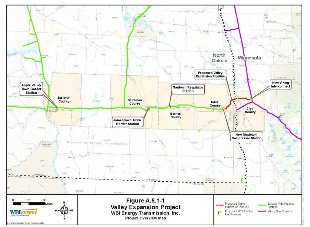
1 FIELD INSPECTION REPORT Date July 10 and 11, 2018 Project WBI Energy Transmission, Inc. Valley Expansion Project Clay County, Minnesota; and Cass County, North Dakota Authority: Section 7(c) Personnel FERC Contractor: FERC Contractor Staff: Company Staff: Tetra Tech, Inc. Chandler Dangle (Tetra Tech) Greg Huncovsky (Environmental Supervisor), GayLynn Lueder (Analyst), and Sunman Rowe (Environmental Inspector) Inspection Summary 1 Problem Area 0 Noncompliances No No Follow-Up Letter Required Refer to Enforcement Introduction On July 10 and 11, 2018, Chandler Dangle of Tetra Tech performed a construction inspection of the WBI Energy Transmission, Inc. (WBI Energy) Valley Expansion Project (Project), under contract to the Federal Energy Regulatory Commission (FERC or Commission) and per the request of the FERC Project Manager, Robin Griffin. The Project consists of the construction and operation of an approximately 37-mile-long, 16-inchdiameter natural gas pipeline, new compressor station (CS), and other appurtenant facilities in Clay County, Minnesota, and Cass County, North Dakota. More specifically, the Project includes: a new bi-directional, approximately 37.3-mile, 16-inch-diameter natural gas pipeline, from a new interconnection with Viking Gas Transmission Company s (Viking) pipeline at milepost (MP) 0.0 in Clay County, Minnesota, to the new Mapleton CS at the end of the pipeline in Cass County, North Dakota (Valley Expansion Pipeline); a new 3,000-horsepower (hp) electric-driven compressor unit and auxiliary equipment at a new CS in Cass County (Mapleton CS); a new regulator station at MP on Line Section 24 in Barnes County, North Dakota (Sanborn Regulator Station);
2 new pig launchers and receivers 1 at the new Mapleton CS and at the Viking Interconnect; appurtenant facilities, including two mainline block valves, gas cleaning and cooling equipment, cathodic protection, gas measurement and regulation equipment, communication equipment, odorization, associated piping and valves, and other facilities; and rebuilding WBI Energy s existing Jamestown town border station approximately 500 feet away from its current location, at MP on Line Section 24 in Stutsman County, North Dakota; relocating WBI Energy s existing Apple Valley town border station to MP 9.5 on Line Section 3 in Burleigh County, North Dakota. The purpose of the Project is to provide approximately 40,000 dekatherms (Dth) per day of firm transportation service on a bidirectional basis between the new interconnection with Viking and the Mapleton CS to meet the demands of two customers. The Project is also designed to enhance system reliability for new and existing WBI Energy customers. The anticipated in-service date for the Project is November 1, The purpose of the inspection was to determine WBI Energy s compliance with the environmental conditions of the Commission s February 15, 2018 Order Issuing Certificate and to inspect the construction conditions of the pipeline right-of-way (ROW) and facilities. The findings of the inspection were that no instances of noncompliance were identified; however, one problem area was documented. A site map, photographic record, and FERC Notification of Required Corrective Action or Response form are presented in this report. Inspection On July 10, 2018, weather conditions were cloudy and stormy, but became partly cloudy to sunny for the rest of the day, with temperatures ranging from mid-60s ( F) to the low-80s ( F) in nearby Fargo, North Dakota. Weather conditions on the second day of the inspection (July 11, 2018) were partly to mostly cloudy, with temperatures ranging from the low-70s ( F) to the low-90s ( F). The Project area received a total of approximately 3.0 inches of precipitation during the two weeks preceding the inspection, including approximately 0.2 inch of precipitation during the morning before the inspection began. Soil conditions were wet but stable. The first day of the inspection (July 10, 2018) focused on the Valley Expansion Pipeline, beginning at the Viking Interconnect (Photo Numbers [Nos.] 1 to 10), and ended at the Mapleton CS and pipeline terminus (Photo No. 11). The second day of the inspection (July 11, 2018) began at the Sanborn Regulator Station (Photo Nos. 12 to 15), and ended at the Jamestown Town Border Station (Photo Nos. 16 to 20). Valley Expansion Pipeline WBI Energy stated that trenching and backfilling were complete to Milepost 10 (approximately Station Number [Sta. No.] ), excluding many of the bored road crossings and other tie-ins (Photo No. 6). Clearing and grading operations were complete up to Milepost 32 (approximately Sta. No ). Overall, construction and environmental conditions were acceptable; however, one problem area was identified at Sta. No , because proper signage was not installed at the Wetland W-A A pig is a tool that moves through the pipeline, and is used for cleaning, internal inspections, or other purposes. A launcher/receiver is an aboveground structure used to install/retrieve pigs from the pipeline.
3 crossing, pursuant to FERC Wetland and Waterbody Construction & Mitigation Procedures (Procedures), Section VI.A.4 (Photo No.7). The proposed Viking Interconnect site was cleared and graded. WBI Energy expected to begin construction of the interconnect facilities near the anticipated in-service date in November 2018 (Photo No. 1). Some erosion control devices (ECDs) were installed, and the edges of the site were seeded and beginning to revegetate. WBI Energy stated that the site will be permanently stabilized with a gravel (No. 3 gravel) groundcover. The predominant land use along the ROW was agricultural, so topsoil was graded from the ROW and segregated from the subsoil. Topsoil was typically graded to a depth of 12 inches, where applicable, according to WBI Energy (Photo Nos. 2 and 3). No mixing with subsoil was evident. WBI Energy stated that landowners and farmers requested that topsoil stockpiles not be seeded or stabilized with mulch to prevent the introduction of weeds. The stockpiles in many places along the ROW were naturally revegetated with volunteer vegetation (Photo No. 3). Topsoil piles were also naturally stabilized due to high soil moisture content and the crust that forms, according to WBI Energy. WBI Energy stated that it left gaps in the topsoil stockpile rows to allow drainage and maintain cropland irrigation systems. WBI Energy continued to monitor areas that were determined to possibly need triplelift segregation to avoid introducing salts into the topsoil, but this technique wasn t necessary as far as the mainline construction had progressed, according to WBI Energy. WBI Energy also stated that it continued to locate and mark drain tiles within and near the ROW with stakes and blue flagging, and that the trench was being excavated deeper in areas where drain tile will be installed in the future. There were several wetland crossings along the ROW, including at several county road borrow ditches. Observed equipment bridges were lined with geotextile fabric. Appropriate signs and ECDs, including silt fence and straw wattles, were also installed along the wetland crossing boundaries (Photo Nos. 5 and 12). WBI Energy used horizontal auger bore crossings to drill under the roads and wetlands, wherever the ROW crossed county roads (Photo Nos. 2 to 5). Proper ROW widths were observed at wetland crossings. WBI Energy explained that even though one wetland (W-A-080) wasn t located in a bar ditch, it would be crossed with a drilled crossing (Photo No. 9). The horizontal directional drill (HDD) crossings of the Red River of the North (Waterbody S-A-003) and the Buffalo River (Waterbody S-A- 004) were successfully drilled, pulled-back, and waiting to be tied-in. The HDD crossing near the Sheyenne River that crosses a ditch (Waterbody S-A-009) was underway (Photo No. 8). No impacts to the sensitive nearby resources or other The Kost contractor yard was being used to store pipe and weighted Pipe Saks. All fuels and hazardous materials were properly housed within containment (Photo No. 10). Mapleton CS The Mapleton CS site was stabilized with aggregate and the banks were built up to resist flooding. The edges of the site were seeded and seed was beginning to germinate (Photo No. 11). Concrete building pads were installed, and WBI energy stated that security fence would be installed soon. ECDs were installed along the access road near the un-named wetlands, and signs were properly installed. No WBI Energy anticipated that construction at the Mapleton CS would be finished by July 15, Sanborn Regulator Station, Jamestown Town Border Station, and Apple Valley Town Border Station The Sanborn Regulator Station was adjacent to one resource, an un-named wetland (Photo No. 12). Silt fence and signage were properly installed along the wetland and active workspace. WBI Energy stated that the mainline valve setting was scheduled to be replaced in September The site was stabilized
4 according to the Project plan and the site was free of significant erosion (Photo Nos. 13 to 15). No The Jamestown Town Border Station facilities were stable (Photo Nos. 16 and 17). New aggregate was used to stabilize the pad and construction entrances (Photos Nos. 18 and 19). WBI stated that an additional entrance to the site (following approval of a variance request) was complete (Photo No. 20). The site was free from erosion and no The Apple Valley Town Border Station was not inspected during this inspection because construction had not yet begun. According to WBI Energy, permission to access the site had been obtained, and biological and cultural surveys were underway. Conclusions and Recommendations A follow-up letter is not required at this time because no instances of noncompliance were identified. Overall, construction was progressing acceptably and environmental conditions were acceptable; however, one problem area was identified because wetland resource signs were missing at the Wetland W-A-034 crossing near Sta. No (Photo No. 7). No resources were impacted and proper signage was corrected within 24 hours, according to WBI Energy. Another inspection is tentatively scheduled for the week of August 6, 2018.
5 SITE MAP


6 Spread: Valley Expansion Photo No.: 1 MP/Sta. No.: 0+00 Direction: East Valley Expansion, Viking Interconnect. The area around the proposed Viking Interconnect was cleared and graded. WBI Energy also seeded along the edges of the workspace and near the entrance to the site. WBI Energy stated that the area was ready for construction of the interconnect facilities. No Photo No.: 2 MP/Sta. No.: Direction: West Valley Expansion, Highway 9 Horizontal Auger Bore Entry Site. The pipeline was lowered-in to the trench. WBI Energy stated it was waiting for drier soil conditions to tie-in the pipeline installed under Highway 9 to the conventionally installed pipeline. The rest of the trench in this area was already backfilled. No environmental concerns were
 was properly segregated and covered with vegetation; no mixing with subsoil was evident.")

7 Spread: Valley Expansion Photo No.: 3 MP/Sta. No.: Direction: East Valley Expansion. The topsoil stockpile (on the right) was properly segregated and covered with vegetation; no mixing with subsoil was evident. WBI Energy stated that landowners and farmers requested that topsoil stockpiles not be seeded or stabilized with mulch to prevent the introduction of weeds. The stockpiles in many places along the ROW were naturally revegetated with volunteer vegetation. No Photo No.: 4 MP/Sta. No.: Direction: West Valley Expansion, County Road 108 Horizontal Auger Bore Entry Site. The drilled road crossing was complete and waiting to be tied-in, once soil conditions improve. WBI Energy stated that the trench will be dewatered, and the water will be discharged into nearby bar ditches where wetland resources are absent. Straw wattles, exclusion fencing, and appropriate signage were installed. No
 lined with geotextile fabric was properly installed across the wetland.")

8 Spread: Valley Expansion Photo No.: 5 MP/Sta. No.: Direction: East Valley Expansion, Wetland W-A An equipment bridge (not pictured) lined with geotextile fabric was properly installed across the wetland. Topsoil was graded to a depth of at least 12 inches, and segregated. Proper signage and ECDs were installed along the ROW. Photo No.: 6 MP/Sta. No.: Direction: West Valley Expansion. Topsoil was graded from the full ROW width to a depth of at least 12 inches, and segregated. Trenching, lowering-in, and backfilling operations were complete up to approximately Sta. No WBI Energy expected clean-up operations to commence within the next three days. No


9 Spread: Valley Expansion Photo No.: 7 MP/Sta. No.: Direction: West Assessment: Problem Area Valley Expansion, Wetland W-A A Problem Area was issued because proper signage was not installed at the Wetland W-A-034 crossing, pursuant to the FERC Procedures, Section VI.A.4. Straw wattles were properly installed at the wetland crossing. Investigations regarding the need to triple-lift the soil to avoid introducing salts into the topsoil continue, but WBI Energy stated that this technique has not been necessary, so far. The site was stable, and no environmental resources were impacted. Photo No.: 8 MP/Sta. No.: Direction: Northeast Valley Expansion, Sheyenne River HDD Entry Site. The HDD crossing of ditch (Waterbody S-A-009) was underway. The drilled crossing does not cross the Sheyenne River, but rather, parallels the river and avoids a sensitive environmental resource. No impacts to the resources or other

 were stored on site (to left of the picture). The edges of the contractor yard were temporarily seeded and revegetated.")
10 Spread: Valley Expansion Photo No.: 9 MP/Sta. No.: Direction: Southwest Valley Expansion, Wetland W-A An equipment bridge lined with geotextile fabric was installed along the wetland crossing as a travel lane. Construction activity was within the approved ROW limits. WBI Energy explained that this wetland crossing will be crossed with a drilled crossing. No environmental concerns were Photo No.: 10 MP/Sta. No.: N/A Direction: North Valley Expansion, Kost Contractor Yard. Pipe and weights ( Pipe Saks ) were stored on site (to left of the picture). The edges of the contractor yard were temporarily seeded and revegetated. All fuels and hazardous materials were properly housed within secondary containment. No environmental concerns were

 and signage were properly installed.")
11 Facilities: Mapleton CS/Sanborn Regulator Station Photo No.: 11 Facility: Mapleton CS Direction: East Unnamed Wetlands. The sides of the access road to the Mapleton CS were stabilized with seed and mulch, and seed was beginning to germinate. Silt fence was installed along the edges of the un-named wetlands. No Photo No.: 12 Facility: Sanborn Regulator Station Direction: North Unnamed Wetland. ECDs (silt fence) and signage were properly installed. The construction pad was stable, and aggregate was in place. No


12 Facility: Sanborn Regulator Station Photo No.: 13 Facility: Sanborn Regulator Station Direction: East Comments: Aboveground Facility. WBI Energy expected that this mainlive valve setting would be replaced in September Temporary ECDs were installed along the edges of the construction pad. The site was stabilized according to the Project plan and the site was free of significant erosion. No Photo No.: 14 Facility: Sanborn Regulator Station Direction: Northeast Comments: Aboveground Facility. The station was stabilized with a gravel groundcover, and the site was free of erosion. No environmental concerns were


13 Facilities: Sanborn Regulator Station/Jamestown Town Border Station Photo No.: 15 Facility: Sanborn Regulator Station Direction: East Comments: Aboveground Facility, Un-named Wetland. The construction entrance was stable and stormwater drainage controls were in place. Straw wattles and silt fence were installed along the wetland boundaries. No environmental concerns were Photo No.: 16 Facility: Jamestown Border Station Direction: West Comments: Agricultural ROW. Straw wattles were installed along the edges of the pad. No


14 Facility: Jamestown Town Border Station Photo No.: 17 Facility: Jamestown Border Station Direction: Southeast Comments: Agricultural ROW. Concrete pads for the new facilities were poured and backfilled. The site was stable, and no erosion or other Photo No.: 18 Facility: Jamestown Border Station Direction: Southwest Comments: Agricultural ROW. The site was stabilized with a gravel groundcover. New aggregate was added, and the site was free from significant erosion. No


15 Facility: Jamestown Town Border Station Photo No.: 19 Facility: Jamestown Border Station Direction: Southwest Comments: Agricultural ROW. The construction entrance was stable and no Photo No.: 20 Facility: Jamestown Border Station Direction: Northwest Comments: Agricultural ROW. WBI Energy stated that a variance request was approved for an additional entrance to the Jamestown Border Station in order to accomodate the adjacent landowner. The construction entrance was stable and no
16 NOTIFICATION OF REQUIRED CORRECTIVE ACTION OR RESPONSE