CITY OF EL CENTRO COMMUNITY DEVELOPMENT DEPARTMENT Planning and Zoning Division 1275 W. Main Street, El Centro, CA 92243
|
|
|
- Gilbert Miller
- 5 years ago
- Views:
Transcription

1 CITY OF EL CENTRO COMMUNITY DEVELOPMENT DEPARTMENT Planning and Zoning Division 1275 W. Main Street, El Centro, CA REQUEST FOR REVIEW AND COMMENTS The attached project and materials are being sent to you for your review and as an early notification that the following project is being requested by the City s Community Development Department. Please review the proposed project based on your agency/department area of interest, expertise, and/or jurisdiction. McCabe Union Elementary School Laura Dubbe City of El Centro City Manager Central Union High School District Renato Montaño City of El Centro City Attorney El Centro Elementary School District- Jon K. LeDoux City of El Centro Building & Safety Meadows Union High School District City of El Centro Finance Dept. Heber School District Jaime Silva City of El Centro Fire Chief Heber Public Utility District Laura Fischer City of El Centro Police Chief Imperial County Office of Education Denise Smith City of El Centro Public Works Director Agricultural Commissioner Connie Valenzuela City of El Centro Senior Engineer Airport Land Use Commission - Richard Cabanilla City of El Centro Community Services Dept. APCD Brad Poiriez El Centro Regional Medical Center IC County Public Works Bill Brunet City of Brawley Rosanna Bayon Moore IC Planning & Development Jim Minnick City of Calexico Armando Villa IC Environmental Health Jeff Lamoure City of Imperial Jorge Galvan LAFCO Jurg Heuberger SCAG Jacob Lieb Imperial Irrigation District Donald Vargas So. California Gas Company Joe Montenegro El Centro NAF David Hulse RWQC Board - Kola Olatunbosum Caltrans District 11 Jacob Armstrong State Clearinghouse CA Fish & Game CA Native American Heritage Commission Date: June 16, 2016 Project ID: Negative Declaration Agency Representative: Enclosed please find a description of a project proposed within the City of El Centro. An initial study has been conducted by the City and the results indicate there are no significant adverse impacts to the environment by the project. A draft Negative Declaration of environmental impact has been prepared for the project. If you, as a responsible agency, have any specific concerns regarding the enclosed Negative Declaration, please submit your comments to this office no later than July 8, 2016 so that your concerns may be reflected on the final document. Your cooperation is greatly appreciated. Sincerely, rma M. Villicana, AICP Director of Community Development Enclosure

2 Environmental Checklist - Initial Study NEGATIVE DECLARATION NO JAIME INVESTMENTS CHANGE OF ZONE AND GENERAL PLAN AMENDMENT 1479, 1461, 1441 & 1423 PICO AVENUE APN , , & JUNE 2016 Prepared By: Angel Hernandez, Assistant Planner City of El Centro Community Development Department Planning & Zoning Division 1275 W. Main Street J:\Planning Department\Environmental Initial Studies -1-
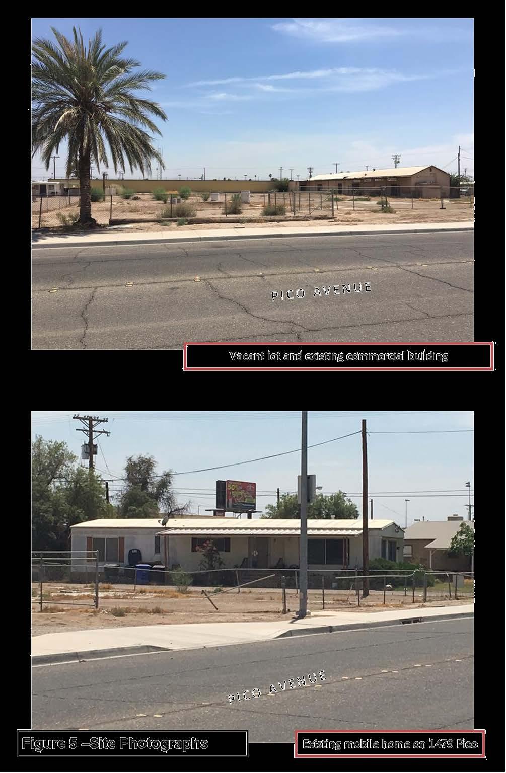
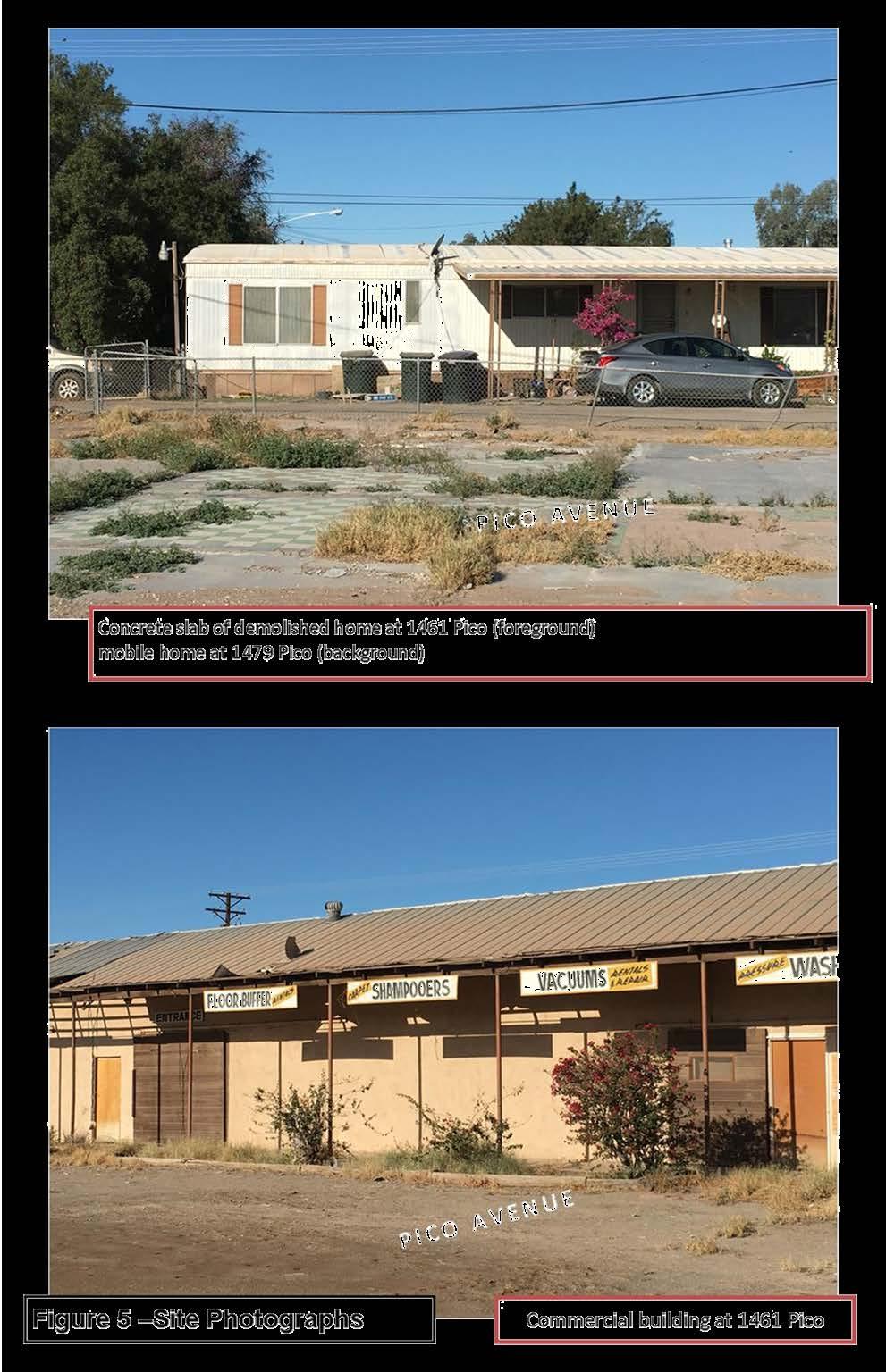
3 ENVIRONMENTAL CHECKLIST/INITIAL STUDY 1. Project title: Jaime Investments Change of Zone and General Plan Amendment 2. Lead agency name and address: City of El Centro 1275 W. Main Street El Centro, CA Contact person and phone number: rma M. Villicaña, Director of Community Development (760) Project location: South side of Pico Avenue between 12 th Street and Imperial Avenue (State Route 86) in El Centro, CA with physical addresses of 1479, 1461, 1441 & 1423 Pico Avenue and Assessor s Parcel Numbers: , , , and , respectively (Refer to Figure 1-Location Map). 5. Project sponsor's name and address: Jaime Investments, LLC 2205 Nixon Avenue Calexico, CA General Plan designation: Current- Low Density Residential Proposed- General Commercial 7. Zoning designation: Current- R1 (Single-Family Residential) Proposed- CG (General Commercial) 8. Description of project: The project consists of a change of zone (COZ 16-01) and general plan amendment (GPA 16-01) affecting four (4) parcels encompassing 1.76 acres of land located within the City of El Centro, California. Please see Figure 2 - Aerial Map of the project site. Jaime Investment Properties, the applicant, wishes to rehabilitate an existing 5,200 square foot building for commercial uses and construct a parking lot on 1461 and 1441 Pico Avenue encompassing.80 acres. The building was previously used for commercial purposes. There are no plans for development on the remaining.96 acres on two properties at the site. Because the property is currently zoned R1 (Single Family Residential), commercial uses are prohibited, so the applicant wishes to have the property rezoned to (CG) General Commercial. An amendment to the General Plan is being requested to designate the project site s land use from Low Density Residential to General Commercial in conformance with the proposed CG Zone. Proposed changes to Zoning and General Plan land use designations are illustrated on Figure 3 Zoning Map and Figure 4 Land Use Designation. The applicant is in the processes of requesting a lot line adjustment to merge 1461 and 1441 Pico Avenue. 9. Surrounding land uses and setting: The site consists of a 260-foot by 300-foot site consisting of four (4) parcels located in the northern portion of the City of El Centro. Structures at the site consist of a mobile home on 1479 Pico, a 5,200 square foot vacant commercial building on 1461 Pico and 1423 Pico are vacant however there are concrete foundations from previous buildings at the site. Please see Figure 5 Site Photographs. J:\Planning Department\Environmental Initial Studies -2-
4 The project is located in the El Dorado neighborhood, located in the northern portion of the City of El Centro. The area was annexed in 1994, and generally consists of single family residences on large lots and areas that were previously used for agricultural purposes. The project site fronts Pico Avenue, a two lane collector roadway per the General Plan. Please see Figure 2 - Aerial Map of the project site and surrounding uses. Uses immediately surrounding the project site are as follows: rth: Pico Avenue and vacant land zoned R1 (Single-family residential) Zone East: Single family residences South: Self storage business West: Mobile home business, building with multiple business tenants including barber, tattoo artist, computer repair and automotive mechanic shop 10. Other public agencies whose approval is required (e.g., permits, financing approval, or participation agreement.) ne J:\Planning Department\Environmental Initial Studies -3-

5 J:\Planning Department\Environmental Initial Studies -4-

6 J:\Planning Department\Environmental Initial Studies -5-

7 J:\Planning Department\Environmental Initial Studies -6-

8 J:\Planning Department\Environmental Initial Studies -7-

9 J:\Planning Department\Environmental Initial Studies -8-
10 J:\Planning Department\Environmental Initial Studies -9-
11 ENVIRONMENTAL FACTORS POTENTIALLY AFFECTED: The environmental factors checked below would be potentially affected by this project, involving at least one impact that is a " " as indicated by the checklist on the following pages. Aesthetics Agriculture & Forestry Air Quality Resources Biological Resources Cultural Resources Geology & Soils Greenhouse Gas Hazards & Hazardous Hydrology & Water Emissions Materials Quality Land Use & Planning Mineral Resources ise Population & Housing Public Services Recreation Transportation & Traffic Utilities and Service Systems Mandatory Findings of Significance DETERMINATION: (To be completed by the Lead Agency) On the basis of this initial evaluation: I find that the proposed project COULD NOT have a significant effect on the environment, and a NEGATIVE DECLARATION will be prepared. I find that although the proposed project could have a significant effect on the environment, there will not be a significant effect in this case because revisions in the project have been made by or agreed to by the project proponent. A MITIGATED NEGATIVE DECLARATION will be prepared. I find that the proposed project MAY have a significant effect on the environment, and an ENVIRONMENTAL IMPACT REPORT is required. I find that the proposed project MAY have a "potentially significant impact" or "potentially significant unless mitigated" impact on the environment, but at least one effect 1) has been adequately analyzed in an earlier document in accordance with applicable legal standards, and 2) has been addressed by mitigation measures based on the earlier analysis as described on attached sheets. An ENVIRONMENTAL IMPACT REPORT is required, but it must analyze only the effects that remain to be addressed. I find that although the proposed project could have a significant effect on the environment, because all potentially significant effects (a) have been analyzed adequately in an earlier EIR or NEGATIVE DECLARATION pursuant to applicable standards, and (b) have been avoided or mitigated pursuant to that earlier EIR or NEGATIVE DECLARATION, including revisions or mitigation measures that are imposed upon the proposed project, nothing further is required. rma M. Villicaña, AICP, Director of Community Development Date J:\Planning Department\Environmental Initial Studies -10-
12 EVALUATION OF ENVIRONMENTAL IMPACTS: 1) A brief explanation is required for all answers except " " answers that are adequately supported by the information sources cited. A " " answer is adequately supported if the referenced information sources show that the impact simply does not apply to projects like the one involved (e.g., the project falls outside a fault rupture zone). A " " answer should be explained when it is based on project-specific factors as well as general standards (e.g., the project will not expose sensitive receptors to pollutants, based on a project-specific screening analysis). 2) All answers must take account of the whole action involved, including off-site as well as on-site, cumulative as well as project-level, indirect as well as direct, and construction as well as operational impacts. 3) Once the lead agency has determined that a particular physical impact may occur, then the checklist answers must indicate whether the impact is potentially significant, less than significant with mitigation, or less than significant. " " is appropriate if there is substantial evidence that an effect may be significant. If there are one or more " " entries when the determination is made, an EIR is required. 4) "Negative Declaration: With " applies where the incorporation of mitigation measures has reduced an effect from " " to a "." The lead agency must describe the mitigation measures, and briefly explain how they reduce the effect to a less than significant level (mitigation measures from Section VII, "Earlier Analyses," may be cross-referenced). 5) Earlier analyses may be used where, pursuant to the tiering, program EIR, or other CEQA process, an effect has been adequately analyzed in an earlier EIR or negative declaration. Section 15063(c)(3)(D). In this case, a brief discussion should identify the following: a) Earlier Analysis Used. Identify and state where they are available for review. b) s Adequately Addressed. Identify which effects from the above checklist were within the scope of and adequately analyzed in an earlier document pursuant to applicable legal standards, and state whether such effects were addressed by mitigation measures based on the earlier analysis. c) Measures. For effects that are "Less than with Measures," describe the mitigation measures that were incorporated or refined from the earlier document and the extent to which they address site-specific conditions for the project. 6) Include references to information sources for potential impacts. Reference to a previously-prepared or outside document should, where appropriate, include a reference to the page. 7) Supporting Information Sources: A source list should be attached, and other sources used or individuals contacted should be cited in the discussion. 8) The explanation of each issue should identify: a) the significance criteria or threshold, if any, used to evaluate each question; and b) the mitigation measure identified, if any, to reduce the impact to less than significance J:\Planning Department\Environmental Initial Studies -11-
13 Issues: with I. AESTHETICS -- Would the project: a) Have a substantial adverse effect on a scenic vista? b) Substantially damage scenic resources, including, but not limited to, trees, rock outcroppings, and historic buildings within a state scenic highway? c) Substantially degrade the existing visual character or quality of the site and its surroundings? d) Create a new source of substantial light or glare that would adversely affect day or nighttime views in the area? (a) The project is located in the City of El Centro, which lies on relatively flat topography. table scenic vistas are limited to distant views of the Superstition Hills, Mt. Signal and the peninsular mountain ranges to the west. Views of these vistas are obscured by existing development to west of the project site. The project will result in no impact to a scenic vista. (b) The site contains a dilapidated commercial building, concrete foundations from previous structures, and abandoned water cisterns. rock outcroppings or notable vegetation is located at the site. The building is to be rehabilitated to be used for commercial uses. The project will not substantially damage scenic resources. (c) Changing the zoning to allow commercial uses will permit the existing commercial building to be rehabilitated and permit site improvements that will improve the visual aesthetics of the project site. (d) Existing sources of light are minimal and are from the existing mobile home at the project site. Exterior wall lighting and parking lot lighting will significantly increase sources of light at the project site. However, lighting will be required to meet outdoor lighting standards found in Section of the City Code. Light fixtures are to be shielded, downward facing and designed not to shine light on adjacent properties or roadways. Implementing existing site lighting regulations will result in a less than significant impact to the views of the area due to light or glare. J:\Planning Department\Environmental Initial Studies -12-
14 Issues: with II. AGRICULTURE & FORESTRY RESOURCES: In determining whether impacts to agricultural resources are significant environmental effects, lead agencies may refer to the California Agricultural Land Evaluation and Site Assessment Model (1997) prepared by the California Dept. of Conservation as an optional model to use in assessing impacts on agriculture and farmland. In determining whether impacts to forest resources, including timberland, are significant environmental effects, lead agencies may refer to information compiled by the California Department of Forestry and Fire Protection regarding state s inventory of forest land, including the Forest and Range Assessment project and the Forest Legacy Assessment project; and forest carbon measurement methodology provided in Forest Protocols adopted by the California Air Resources Board. Would the project: a) Convert Prime Farmland, Unique Farmland, or Farmland of Statewide Importance (Farmland), as shown on the maps prepared pursuant to the Farmland Mapping and Monitoring Program of the California Resources Agency, to non-agricultural use? b) Conflict with existing zoning for agricultural use, or a Williamson Act contract? c) Conflict with existing zoning for, or cause, rezoning of, forest land (as defined in Public Resources Code section 12220(g)), timberland (as defined, by the Public Resources Code section 4526), or timberland zoned Timberland Production (as defined by Governmental Code section 51104(g))? d) Result in the loss of forest land or conversion of forest land to non-forest use? e) Involve other changes in the existing environment which, due to their location or nature, could result in conversion of Farmland, to non-agricultural use or conversion of forest land to non-forest use? (a-b) The project site is designated as Urban and Built Up Land under the 2012 Farmland Mapping and Monitoring Program of the California Resources Agency. Urban and Built-Up Land is defined as built-up land occupied by structures with a building density of at least 1 unit to 1.5 acres. As such, the proposed project site will not convert Prime Farmland, Unique Farmland, or Farmland of Statewide Importance to non-agricultural uses. Given that the proposed project site is not zoned for agricultural use, the project will not conflict with any Williamson Act contract. (c) Currently, the land is zoned for single-family residential uses. As such, the project will not conflict with existing zoning for, or cause, rezoning of, forest land, timberland, or timberland zoned Timberland Production. (d) The project will not result in the loss of forest land or conversion of forest land to non-forest use as the site is zoned for single family residential land uses and does not consist of forest land. (e) The proposed project will not involve other changes in the existing environment which could result in the conversion of farmland to non-agricultural use or conversion of forest land to non-forest use. Pursuant to the Farmland Mapping and Monitoring Program land to the north, east, south and west is designated Urban and Built- Up land. There is no forest land near the project area or within the project area; thus, there will be no impact to forest lands. J:\Planning Department\Environmental Initial Studies -13-
15 Issues: with III. AIR QUALITY -- Where available, the significance criteria established by the applicable air quality management or air pollution control district may be relied upon to make the following determinations. Would the project: a) Conflict with or obstruct implementation of the applicable air quality plan? b) Violate any air quality standard or contribute substantially to an existing or projected air quality violation? c) Result in a cumulatively considerable net increase of any criteria pollutant for which the project region is non-attainment under an applicable federal or state ambient air quality standard (including releasing emissions which exceed quantitative thresholds for ozone precursors)? d) Expose sensitive receptors to substantial pollutant concentrations? e) Create objectionable odors affecting a substantial number of people? (a-c) The project site is located in Imperial County which is designated as a non-attainment area for particulate matter (PM) 2.5, PM 10, and 8-hour ozone standards. The Imperial County Air Pollution Control District (ICAPCD) has approved State Implementation Plans to reduce emissions of these pollutants. Construction phase activities as a result of the project include the running of heavy machinery, dirt excavation, and building renovation will generate particulate matter. Construction will require the preparation of a dust control plan and implement measures included therein to limit visible dust emissions below 20 percent opacity. Operational phase activities that generate particulate matter resulting from the use of commercial buildings are motor vehicle emissions from trips to and from the site and emissions from generating electricity for the building. Due to the size of the project site, future commercial development is determined not to have a significant impact to particulate matter generation. During construction, sources of ozone consist of emissions from engines powering construction equipment and auxiliary power sources. Equipment or machinery that emits air contaminates are required to obtain a Permit to Operate from ICAPCD. All new commercial development is required to pay an operational development fee to mitigate the emissions from new commercial development including increase vehicle emissions and power generation emissions. (d) A sensitive receptor is a person in the population who is particularly susceptible to health effects due to exposure to an air contamination. Sensitive receptor land uses include, schools, child-care centers, playgrounds, hospitals, retirement homes, and single/multi-family residential dwellings. The project abuts a single-family residential neighborhood, and an existing home is within the project site. Dust and heavy equipment emissions will occur during construction, however the applicant will be required to comply with ICAPCD regulations during construction to prevent air quality from impacting nearby homes. (e) The proposed project will allow the development of commercial development. Uses that may generate any objectionable odors are prohibited in all commercial areas and no noxious fumes or odors would result from the project. J:\Planning Department\Environmental Initial Studies -14-
16 Issues: IV. BIOLOGICAL RESOURCES -- Would the project: with a) Have a substantial adverse effect, either directly or through habitat modifications, on any species identified as a candidate, sensitive, or special status species in local or regional plans, policies, or regulations, or by the California Department of Fish and Wildlife or U.S. Fish and Wildlife Service? b) Have a substantial adverse effect on any riparian habitat or other sensitive natural community identified in local or regional plans, policies, regulations or by the California Department of Fish and Wildlife or US Fish and Wildlife Service? c) Have a substantial adverse effect on federally protected wetlands as defined by Section 404 of the Clean Water Act (including, but not limited to, marsh, vernal pool, coastal, etc.) through direct removal, filling, hydrological interruption, or other means? d) Interfere substantially with the movement of any native resident or migratory fish or wildlife species or with established native resident or migratory wildlife corridors, or impede the use of native wildlife nursery sites? e) Conflict with any local policies or ordinances protecting biological resources, such as a tree preservation policy or ordinance? f) Conflict with the provisions of an adopted Habitat Conservation Plan, Natural Community Conservation Plan, or other approved local, regional, or state habitat conservation plan? (a-f) The project site consists of land within an urbanized area and devoid of any vegetation, bodies of water or wildlife corridors that could sustain wildlife or lead to the establishment thereof. Single family residences and a commercial building previously occupied the site. The area has been previously disturbed from construction operations and it would be unlikely that any sensitive species would be located at the site or would populate the site. Thus, the proposed project will not have a substantial adverse effect on any riparian habitat, or a substantially adverse effect on federally protected wetlands, or interfere with the movement of any native resident or migratory fish or wildlife species. Therefore, no impacts to biological resources would result from the proposed project. J:\Planning Department\Environmental Initial Studies -15-
17 Issues: with V. CULTURAL RESOURCES -- Would the project: a) Cause a substantial adverse change in the significance of a historical resource as defined in ? b) Cause a substantial adverse change in the significance of an archaeological resource pursuant to ? c) Directly or indirectly destroy a unique paleontological resource or site or unique geologic feature? d) Disturb any human remains, including those interred outside of formal cemeteries? (a-d) Previous uses at the project site include low density residential and commercial uses for several decades. In the unlikely event of the discovery of human remains during construction, State law (Section of the Health and Safety Code, and Section of the Public Resources Code of the State of California) requires that there shall be no further excavation or disturbance of the site or any nearby area reasonably suspected to overlie adjacent remains until local authorities are notified and proper notification protocols followed. J:\Planning Department\Environmental Initial Studies -16-
18 Issues: with VI. GEOLOGY AND SOILS -- Would the project: a) Expose people or structures to potential substantial adverse effects, including the risk of loss, injury, or death involving: i) Rupture of a known earthquake fault, as delineated on the most recent Alquist-Priolo Earthquake Fault Zoning Map issued by the State Geologist for the area or based on other substantial evidence of a known fault? Refer to Division of Mines and Geology Special Publication 42. ii) Strong seismic ground shaking? iii) Seismic-related ground failure, including liquefaction? iv) Landslides? b) Result in substantial soil erosion or the loss of topsoil? c) Be located on a geologic unit or soil that is unstable, or that would become unstable as a result of the project, and potentially result in on- or off-site landslide, lateral spreading, subsidence, liquefaction or collapse? d) Have soils incapable of adequately supporting the use of septic tanks or alternative waste water disposal systems where sewers are not available for the disposal of waste water? (a) The project site is located in Imperial Valley a seismically active area. Within 4 miles of El Centro is the Imperial fault zone to the northwest and the Brawley fault zone to the northeast and east. According to data from the United States Geological Survey, six earthquakes with epicenters within 20 miles of El Centro have been documented with a magnitude of 4.5 or greater on the Richter Scale since Soils in the area also have high shrink-swell potential and the potential for liquefaction due to earthquakes. The proposed project will require implementation of project design measures and adherence to the California Building Code. Implementation of these design and building techniques would reduce the impacts to a level that is less than significant. (b) The project site has been previously developed and will not result in soil erosion or the loss of topsoil. (c)the proposed project site is not located on an unstable geologic unit. The proposed project would not induce geologic or soil instability on or offsite. (d) The proposed project will be connected to city sewer services. J:\Planning Department\Environmental Initial Studies -17-
19 Issues: with VII. GREENHOUSE GAS EMISSIONS -- Would the project: a) Generate greenhouse gas emissions, either directly or indirectly, that may have a significant impact on the environment? b) Conflict with any applicable plan, policy or regulation of an agency adopted for the purpose of reducing the emissions of greenhouse gases? (a-b) Increase greenhouse gas emissions from construction activities, electricity generation and additional vehicle trips will be less than significant. The proposed project would not generate significant greenhouse gas emissions that could significantly impact the environment. The project will also not conflict with any applicable plan, policy or regulation adopted for the purposes of reducing greenhouse gas emissions. J:\Planning Department\Environmental Initial Studies -18-
20 Issues: with VIII. HAZARDS AND HAZARDOUS MATERIALS Would the project: a) Create a significant hazard to the public or the environment through the routine transport, use, or disposal of hazardous materials? b) Create a significant hazard to the public or the environment through reasonably foreseeable upset and accident conditions involving the release of hazardous materials into the environment? c) Emit hazardous emissions or handle hazardous or acutely hazardous materials, substances, or waste within one-quarter mile of an existing or proposed school? d) Be located on a site which is included on a list of hazardous materials sites compiled pursuant to Government Code Section and, as a result, would it create a significant hazard to the public or the environment? e) For a project located within an airport land use plan or, where such a plan has not been adopted, within two miles of a public airport or public use airport, would the project result in a safety hazard for people residing or working in the project area? f) For a project within the vicinity of a private airstrip, would the project result in a safety hazard for people residing or working in the project area? g) Impair implementation of or physically interfere with an adopted emergency response plan or emergency evacuation plan? h) Expose people or structures to a significant risk of loss, injury or death involving wildland fires, including where wildlands are adjacent to urbanized areas or where residences are intermixed with wildlands? (a-c) The project will result in the commercial development consistent with uses allowed in the General Commercial zone. This zone is intended for general business, light service and retail uses, as well as large-scale planned shopping districts and, where appropriate, hotel and public assembly uses. Uses permitted in this zone do not routinely transport, use, or dispose of hazardous materials. (d) The site is not listed as a hazardous waste and substances site list on Geotracker. (e) A Land Use Compatibility Plan has been established for the Imperial County Airport located 1.5 miles to the northwest of the project site. However, the project site is not within the plan area. (f) The project site is not located within the vicinity of a private airstrip and by extension will not result in a safety hazard for people working near the project area. (g) The project does not involve a land use or activity that could interfere with emergency-evacuation plans for the area. (h) The project site is located within an urbanized area, far removed from wildland areas. J:\Planning Department\Environmental Initial Studies -19-
21 Issues: with I. HYDROLOGY AND WATER QUALITY -- Would the project: a) Violate any water quality standards or waste discharge requirements? b) Substantially deplete groundwater supplies or interfere substantially with groundwater recharge such that there would be a net deficit in aquifer volume or a lowering of the local groundwater table level (e.g., the production rate of pre-existing nearby wells would drop to a level which would not support existing land uses or planned uses for which permits have been granted)? c) Substantially alter the existing drainage pattern of the site or area, including through the alteration of the course of a stream or river, in a manner which would result in substantial erosion or siltation on- or offsite? d) Substantially alter the existing drainage pattern of the site or area, including through the alteration of the course of a stream or river, or substantially increase the rate or amount of surface runoff in a manner which would result in flooding on- or off-site? e) Create or contribute runoff water which would exceed the capacity of existing or planned stormwater drainage systems or provide substantial additional sources of polluted runoff? f) Otherwise substantially degrade water quality? g) Place housing within a 100-year flood hazard area as mapped on a federal Flood Hazard Boundary or Flood Insurance Rate Map or other flood hazard delineation map? h) Place within a 100-year flood hazard area structures that would impede or redirect flood flows? i) Expose people or structures to a significant risk of loss, injury or death involving flooding, including flooding as a result of the failure of a levee or dam? j) Inundation by seiche, tsunami, or mudflow? (a,b) The project would not violate any water quality standards or discharge requirements. The project would also not deplete ground water resources as potable water is available to the site. (c-e) The project will result in development at the site and will increase the area of impervious surfaces and produce surface runoff. Prior to issuance of any buildings permits, grading and drainage plans shall be prepared in accordance with City requirements to reduce the amount of surface runoff from entering public storm water facilities and minimize flooding or polluted runoff. Implementation of City storm water requirements and regulations will result in in a less than significant impact resulting from surface runoff. (f) The proposed project will not otherwise degrade water quality. (g,h)the project is not located within a 100-year flood hazard area as identified by FEMA Maps. As such the project will not lead to flooding of structures or redirect flood flows. J:\Planning Department\Environmental Initial Studies -20-
22 (i,j) The project is not located near a dam, levee or within an area susceptible to seichis, tsunamis or mudflows. Issues: with. LAND USE AND PLANNING - Would the project: a) Physically divide an established community? b) Conflict with any applicable land use plan, policy, or regulation of an agency with jurisdiction over the project (including, but not limited to the general plan, specific plan, local coastal program, or zoning ordinance) adopted for the purpose of avoiding or mitigating an environmental effect? c) Conflict with any applicable habitat conservation plan or natural community conservation plan? (a) The proposed project will not physically divide an established community. It will result in rezoning land for commercial uses and abuts existing commercial uses to the west that fronts Imperial Avenue, a major commercial corridor. (b) The proposed change of zone will allow commercial uses on property where only residential uses are currently permitted. Concurrently an amendment to the General Plan will also be processed to modify the land use map to be consistent with the new zoning designation. The lot line adjustment will merge two parcels and will not conflict with any land use plans. (c) There is no habitat conservation or natural community conservation plans that are applicable to the site. I. MINERAL RESOURCES -- Would the project: Issues: with a) Result in the loss of availability of a known mineral resource that would be of value to the region and the residents of the state? b) Result in the loss of availability of a locallyimportant mineral resource recovery site delineated on a local general plan, specific plan or other land use plan? (a,b) The project site is within an urban area and is not identified in the General Plan as having any known mineral resource value or as being located within any mineral resource recovery site. J:\Planning Department\Environmental Initial Studies -21-
23 II. NOISE Would the project result in: Issues: with a) Exposure of persons to or generation of noise levels in excess of standards established in the local general plan or noise ordinance, or applicable standards of other agencies? b) Exposure of persons to or generation of excessive groundborne vibration or groundborne noise levels? c) A substantial permanent increase in ambient noise levels in the project vicinity above levels existing without the project? d) A substantial temporary or periodic increase in ambient noise levels in the project vicinity above levels existing without the project? e) For a project located within an airport land use plan or, where such a plan has not been adopted, within two miles of a public airport or public use airport, would the project expose people residing or working in the project area to excessive noise levels? f) For a project within the vicinity of a private airstrip, would the project expose people residing or working in the project area to excessive noise levels? (a,b) The proposed project will involve rehabilitation of the existing building and construction of a parking area. ise levels during the construction may temporary exceed noise levels as established in the ise Element of the General Plan, however they shall be required to meet noise City requirements for the operation of construction equipment. (c) The proposed project will result in a permanent but negligible increase of ambient noise levels in the project s vicinity. The project will result in the development of vacant land for the commercial uses. Abutting the property to the east are R1-Zone properties. In order to reduce impacts from noise generated at the project site, a 10 to 20 foot setback will be required abutting the eastern property line and construction of a six-foot high masonry wall. (d) There will be a temporary increase in noise as a result of construction. However, construction noise will be minimal given the short term duration of construction. (e) The project site is not located within an airport land use plan and as such exposure to residents at the project site from aircraft noise will be less than significant. (f) The project is located outside the influence area of a private airstrip. J:\Planning Department\Environmental Initial Studies -22-
24 III. POPULATION AND HOUSING -- Would the project: Issues: with a) Induce substantial population growth in an area, either directly (for example, by proposing new homes and businesses) or indirectly (for example, through extension of roads or other infrastructure)? b) Displace substantial numbers of existing housing, necessitating the construction of replacement housing elsewhere? c) Displace substantial numbers of people, necessitating the construction of replacement housing elsewhere? (a) The proposed project will result in the rehabilitation of a building and allow for the future commercial development at the project site. This is likely to result in an increase of new businesses, but not to a degree that will result in a significant increase of population due to the size of the parcel. (b,c) The project will not result in a substantial displacement of housing or persons that will required the construction of replacement housing. J:\Planning Department\Environmental Initial Studies -23-
25 IV. PUBLIC SERVICES Issues: with a) Would the project result in substantial adverse physical impacts associated with the provision of new or physically altered governmental facilities, need for new or physically altered governmental facilities, the construction of which could cause significant environmental impacts, in order to maintain acceptable service ratios, response times or other performance objectives for any of the public services: Fire protection? Police protection? Schools? Parks? Other public facilities? (a) The City of El Centro Fire Department (ECFD) provides service within the City Limits. Additionally, ECFD responds to mutual aids throughout the Imperial Valley and the State when requested through mutual aid agreements with Imperial Valley Fire Departments and the State of California. The ECFD has three (3) stations staffed on a 24-hour basis to serve the public as follows: Station #1 is located at 775 State Street, Station #2 is located at 900 S. Dogwood Avenue, and Station #3 is located at 1910 N. Waterman Avenue. The Fire Department logged an average response time of approximately 4 to 6 minutes for emergency calls and 10 to 15 minutes for non-emergency calls. It is not anticipated that the rehabilitation of the existing building for commercial uses or future commercial development will result in substantial adverse physical impacts to fire facilities. The project site is adjacent to El Centro Fire Station #3 and would be served by this station. The City of El Centro Police Department (ECPD) is the primary law enforcement agency that serves the citizens of the City and land within the City boundaries. The Police Department has a main police station, located at 150 N. 11 th Street. The City of El Centro has a total of 50 sworn officers, employs 24 non-sworn personnel and has an average emergency response time of 7-10 minutes. The project will not significantly increase the demand of police protection and will not require the construction of new police facilities. The project will allow for commercial development and is unlikely to result significantly increasing the demand for schools, parks or other public facilities. Furthermore, new development will be subject to development impact fees to mitigate increases for demand of schools, parks, fire protection, police projection, and administrative facilities. This will result in a less than significant impact to public services. J:\Planning Department\Environmental Initial Studies -24-
26 V. RECREATION -- Issues: with a) Would the project increase the use of existing neighborhood and regional parks or other recreational facilities such that substantial physical deterioration of the facility would occur or be accelerated? b) Does the project include recreational facilities or require the construction or expansion of recreational facilities that might have an adverse physical effect on the environment? (a,b) The project will allow for commercial development and is unlikely to result in an increase in the use of existing neighborhood and regional parks or other recreational facilities, as the proposed project will not induce a significant increase in the population. Prior to issuance of a building permit, development impact fees for parks will have to be paid to offset increase park and recreational facility use. The proposed project will not induce population growth to a degree large enough that would require the expansion of recreational facilities that would have an adverse effect on the environment. J:\Planning Department\Environmental Initial Studies -25-
27 VI. TRANSPORTATION/TRAFFIC -- Would the project: Issues: with a) Conflict with an applicable plan, ordinance or policy establishing measures of effectiveness for the performance of the circulation system, taking into account all modes of transportation including mass transit and non-motorized travel and relevant components of the circulation system, including but not limited to intersections, streets, highways and freeways, pedestrian and bicycle paths, and mass transit? b) Conflict with an applicable congestion management program, including, but not limited to level of service standards and travel demand measures, or other standards established by the county congestion management agency for designated roads or highways? c) Result in a change in air traffic patterns, including either an increase in traffic levels or a change in location that result in substantial safety risks? d) Substantially increase hazards due to a design feature (e.g., sharp curves or dangerous intersections) or incompatible uses (e.g., farm equipment)? e) Result in inadequate emergency access? f) Conflict with adopted policies, plans, or programs regarding public transit, bicycle, or pedestrian facilities, or otherwise decrease the performance or safety of such facilities? (a) The proposed project will allow for the rehabilitation of an existing 5,200 square foot commercial building and allow for future commercial development on the remaining.96 acres of land. Table C-3 of Circulation Element of the General Plan estimates that commercial uses generate 200 trips per acre of land and 16 per every 1,000 square feet of building space, or up to 275 daily trips at the project site (83 trips from the building and 192 from the remaining land once developed). The site fronts Pico Avenue which is designated as a collector roadway per the Circulation Element of the General Plan. Collector roadways are designed to serve secondary traffic generators such as shopping and business centers. Furthermore, the project site is within 500 feet from Imperial Avenue designated as Arterial streets in the General Plan. Considering the proposed development is consistent with the uses served by existing roadways classifications per the General Plan, the project will not have a significant impact to City s traffic circulation system. (b) The project will not conflict with an applicable congestion management program, including level of service standards, travel demand measures, or other standards established by the City or the county congestion management agency. (c) The project will not affect air traffic patterns. (d,e) The proposed project will not increase hazards due to a design feature as the proposed project does not involve construction that would increase hazards. The project would not result in inadequate emergency access. (f) The proposed project would not conflict with adopted policies related to traffic, circulation, and pedestrian facilities. J:\Planning Department\Environmental Initial Studies -26-
28 VII. UTILITIES AND SERVICE SYSTEMS Would the project: Issues: with a) Exceed wastewater treatment requirements of the applicable Regional Water Quality Control Board? b) Require or result in the construction of new water or wastewater treatment facilities or expansion of existing facilities, the construction of which could cause significant environmental effects? c) Require or result in the construction of new storm water drainage facilities or expansion of existing facilities, the construction of which could cause significant environmental effects? d) Have sufficient water supplies available to serve the project from existing entitlements and resources, or are new or expanded entitlements needed? e) Result in a determination by the wastewater treatment provider which serves or may serve the project that it has adequate capacity to serve the projects projected demand in addition to the provider s existing commitments? f) Be served by a landfill with sufficient permitted capacity to accommodate the project s solid waste disposal needs? g) Comply with federal, state, and local statutes and regulations related to solid waste? (a) The El Centro Wastewater Treatment Plant (WWTP) has the capacity to accommodate 8.0 million gallons of wastewater per day. The treatment plant would be able to treat additional wastewater as it has sufficient capacity. The project site is connected to the City s sewer system. New development at the site will be required to pay applicable wastewater capacity fees to offset impacts from the increase wastewater generated. (b) The proposed project will not require or result in the construction of water or wastewater treatment facilities. As such, there will no environmental impacts due to the construction of water and wastewater treatment facilities. Both, water and wastewater treatment facilities have the capacity to continue to serve the project. (c) The project will increase the area of impervious surfaces at the project site and would require the construction of stormwater drainage facilities. Onsite stormwater drainage shall be design to keep surface runoff onsite and will not require the expansion or construction of public drainage facilities. (d) The City of El Centro Water Treatment Plant (WTP) is permitted through the State Department of Public Health and has a capacity of 14 million gallons per day and has the available capacity to serve the project site. The City of El Centro receives raw water from the Imperial Irrigation District and treats the raw water for consumption for use by its customers. The City of El Centro has sufficient water supplies available to serve the project from existing entitlements and resources and no new or expanded entitlements are needed to serve the site. (e) As stated, the City of El Centro WWTP serves the project site. There will be no significant increase in demand to the WWTP as a result of the project. (f-g) The current solid waste service provider is CR&R Waste Services, who has sufficient landfill capacity to serve the project site. The City of El Centro has renewed its contract with CR&R through Any future development at the site must comply with all applicable federal, state and local statutes and regulations pertaining to solid waste. J:\Planning Department\Environmental Initial Studies -27-
29 VIII. MANDATORY FINDINGS OF SIGNIFICANCE -- Issues: with a) Does the project have the potential to degrade the quality of the environment, substantially reduce the habitat of a fish or wildlife species, cause a fish or wildlife population to drop below self-sustaining levels, threaten to eliminate a plant or animal community, reduce the number or restrict the range of a rare or endangered plant or animal or eliminate important examples of the major periods of California history or prehistory? b) Does the project have impacts that are individually limited, but cumulatively considerable? ("Cumulatively considerable" means that the incremental effects of a project are considerable when viewed in connection with the effects of past projects, the effects of other current projects, and the effects of probable future projects)? c) Does the project have environmental effects that will cause substantial adverse effects on human beings, either directly or indirectly? (a-c) The project would allow for commercial development on 1.76 acres of previously disturbed land. Development at the site consists of rehabilitation of a 5,200 square foot building and construction of a parking area on.80 acres of the project site. development is proposed on the remaining.96 acres which consist of vacant land with one mobile home. Construction at the site may result in temporary impacts to sound and air quality, however enforcement of existing air quality and construction requirements will result in a less than significant impact. Rehabilitation of the building will result in an increase in traffic generated to an estimated 83 new trips per day. Commercial development at the remaining portion of the project site is estimated to generate, up to 192 daily trips. Vehicle access to the project site will be via Pico Avenue, a roadway designated as a collector roadway per the General Plan, and can accommodate the additional vehicle trips generated by the project. Overall, the proposal will not have a significant impact on the environment as project will result in infill development on property within a developed portion of the City of El Centro. J:\Planning Department\Environmental Initial Studies -28-
30 FINDINGS The environmental analysis of this Initial Study indicates that the proposed project would not have the potential for significant adverse environmental impacts. The following findings can be made regarding the mandatory findings of significance set forth in Section of the CEQA Guidelines, as based on the results of this environmental assessment: The proposed project would not have the potential to degrade the quality of the environment and would not reduce the habitat of a fish or wildlife species, cause a fish or wildlife population to drop below self-sustaining levels, threaten to eliminate a plant or animal community, or reduce the number or restrict the range of a rare or endangered plant or animal or eliminate important examples of the major periods of California history or prehistory. The proposed project would not have the potential to achieve short-term goals at the expense of long-term environmental goals. The proposed project would not have immitigable environmental impacts, which are individually limited but cumulatively considerable, when considering planned or proposed development in the immediate vicinity of the site. The proposed project would not cumulatively lead to significant adverse impacts that cannot be mitigated to a level of less than significance, when added to proposed, planned, or anticipated development in the area. The proposed project would not have environmental impacts, which may have adverse effects on humans, either directly or indirectly. The City of El Centro has determined that the proposed project would not have significant adverse impacts on the environment and no additional environmental analysis. The City of El Centro intends to adopt a Negative Declaration for proposed Change of Zone and General Plan Amendment SOURCE REFERENCES The following is a list of references used in the preparation of this environmental document. Unless attached herein, copies of all referenced reports, memorandums and letters are on file with the City of El Centro Community Development Department Planning & Zoning Division. References to Publications prepared by Federal or State agencies may be found with the agency responsible for providing such information. 1) California Department of Conservation-Division of Land Resources Protection Imperial County Important Farmland 2014 Map 2) City of El Centro City of El Centro General Plan 3) City of El Centro Chapter 29-Zoning 4) Imperial County Air Pollution District Imperial County 2013 State Implementation Plan for the Hour PM2.5 Moderate nattainment Area 5) Imperial County Air Pollution District Imperial County State Implementation Plan for Particulate Matter 10 Microns In Aerodynamic Diameter 6) Imperial County Air Pollution District Hour Ozone Modified Air Quality Management Plan 7) "Search Earthquake Archives." Search Earthquake Archives. United States Geological Survey, n.d. Web. 13 June J:\Planning Department\Environmental Initial Studies -29-