Using Decision Support Tools to Improve Assessment and Clean-up
|
|
|
- Collin Miller
- 5 years ago
- Views:
Transcription
1 Using Decision Support Tools to Improve Assessment and Clean-up Brian Cooper, USEPA Region 5 Superfund Division Dr. Jim Weaver, USEPA Office of Research and Development, Athens, Georgia Dr. David Miller, Argonne National Labs Robert Stewart, University of Tennessee
2 Why do we need Decision Support Tools? Integrate many different technologies: GIS/GPS/Data Bases/Visualization Effective way to communication to decisionmakers and public about environmental problems and solutions Speed Clarity Repeatability Accuracy Standardization Dependability
3 What the Tools Do Not Provide Tools should be robust and not black-boxed! Biologists, environmental scientists, geologists, risk assessors. are still needed. Good data are needed. GIGO (Garbage In Garbage Out) Data QA/QC is essential
4 Brian Cooper Environmental Scientist/FIELDS Manager United States Environmental Protection Agency Region 5 Superfund Division cooper.brian@epa.gov
5 U.S. EPA Region 5 Superfund FIELD ENVIRONMENTALDECISION SUPPORT


6 FIELDS Services Assistance for: Field Planning On site assistance Mapping Data Storage Monitoring Decision making

7 Where is FIELDS now? Over 75 Region 5 Superfund and Water Division sites Active participation on projects in Regions 2, 3, 5, 6,7,8, 9, and 10 Training given to individuals from all regions, state and tribal government, and independent contractors Technology transfers in China and Latvia Contaminated soil and sediment


8 FIELDS Technology DATABASE QUERY GIS VISUALIZATION GPS


9 FIELDS System Components ArcView based 2D Extensions Avenue, VB, and C++ dlls F/S Plus Standalone 2D/3D Viewer and Analysis Tools
10 FIELDS Methods Contaminated Sediment Site Characterization Using the FIELDS Methodology Standardized characterization process Integration of FIELDS Decision Support Tools
11 The FIELDS approach: Gather historical data and perform preliminary data analyses Define an area or areas to be characterized Create a sampling plan (physical and chemical) using USEPA data quality methods Collect sample data using standard operating procedures
12 The FIELDS approach (cont d): Use these sample data to model the extent of contamination Use modeled values to calculate mass and volume of contamination Develop remediation strategies based on clean-up goals
13 Methods Gather available historical data: 1. Analytical data (ecological, chemical, human health) 2. GIS coverages 3. Aerial photographs 4. Physical characteristics (flow rates, sediment thickness, sediment type, etc.) 5. Historical and/or current contaminant sources


14 Historical Data Existing sample databases Current/historical images GIS coverages HH/Eco Studies Other information Digital Digital Orthoquads Features from from GPS GPS Hydrology Land Land cover cover Compilation Map Map

15 Collect New Data

16 Determine Sediment Thickness Manual probes GPR Seismic Profiling Chirp devices

17

18 Create Sample Designs Statistically based-when possible hot spot search Collect accurate spatial information Determine spatial correlation of values multi-staged sampling? Sediment detail for layer correlation

19 FIELDS Sample Design Module How many samples do I take? Where should I take samples? Consider data quality objectives


20 Statistically based Sample Design
21

22 Data Collection

23 Input to a Standard Database Structure Local Computers GPS Internet

24 Data Query Tool Query capabilities: Criteria parameter, units Options non-detects, results, dates Total all results, etc. User Defined 2D Interval all, maximum, DWA


25 Data Query Tool Example query output, as shapefile
26


27 Load to GPS Clicking on this tool will convert your sampling locations into an ASCII file that can be exported to GPS.
28 Methods Model extent of contamination 1. Incorporate bathymetric and sediment thickness data in order to define sediment layers 2. Employ the FIELDS tools to generate estimated contaminant values at unsampled locations


29 FIELDS 2D Modeling Module Inverse Distance Weighting and Natural Neighbor

 with the lowest root mean square")
30 Cross Validation Best power and neighbor for IDW The cross validation for IDW algorithm finds the parameters (power and number of neighbors) with the lowest root mean square error.


31 Estimation Error Reporting Compares interpolated values with original values Useful for comparing different interpolation methods.

32 A FIELDS System Approach to Kalamazoo River Removal Assessment Interpolation of PCB Distribution - FIELDS Query and Natural Neighbor Tools
33 Methods Use the FIELDS tools to calculate mass and volume of contaminant data
 Media Density")
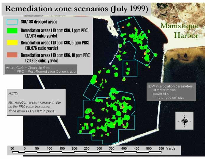
34 Mass/Volume Dialog Box Four input categories: Interpolated Concentration Grids Interpolated Depth Grid Concentration Ranges (e.g., TOSCA, non-tosca wastes) Media Density

35 Mass and Volume Interval 0-1 feet Interval 1-2 feet Interval 2-3 feet Interval 3-4 feet Interval 4-5 feet Interpolated Concentration Intervals Interval 5-6 feet Interval 6-7 feet


36 Mass/Volume Tool Calculates mass of contaminant Calculates volume of contaminated media

37

38 Mass / Volume Calculations A FIELDS System Approach to Kalamazoo River Removal Assessment Kalamazoo River: Cumulative Volum es of PCB Contaminated Exposed Sediments to 6 6 to t o t o t o t o > 1 > 2 > 5 > 10 > 25 PPM Total PCB Cumulative Proportions of Mass by Layer Soil and Exposed Sediment 0 to 6 inches 0 to 12 inches 0 to 24 inches 0 to 36 inches 0 to 48 inches all Layer Proportion Proportion of Mass and Volume Above Concentration Threshold Soils and Exposed Sediment volume mass Concentration (ppm)
39 Methods Use the FIELDS tools to determine remediation strategies
.")

40 Risk Assessment // Clean-Up Goals Determine the action level (AL). In this case, the AL is based on risk from human consumption of contaminated fish. FISH SEDIMENT


41 Human Health Risk Assessment Estimate human health risks from exposure to pollutants Developed by SADA Utilizes ArcView Functionality Follows EPA RAGS (Risk Assessment Guidance For Superfund)


42 Developed by SADA Ecological Risk Module Uses sample values to identify locations or areas of a site that exceed or are predicted to exceed selected benchmarks (thresholds) Data screening Probability maps Follows Ecological Risk Assessors Forum (ERAF) guidelines


43 Remediation Tool Determine remediation areas Block-based removes all cells with values >= the removal concentration Site-based removes the highest, replaces it with the Expected fill concentration, and recalculates the average No Yes Remediation areas


44 Remediation Tool Report and Table
45

46 Final Products Maps Analyses Post-remediation (were goals met?) Communication with decision-makers Proportion Proportion of Mass and Volume Above Concentration Threshold Soils and Exposed Sediment volume mass Concentration (ppm)

47 FIELDS Website: FIELDS Management Brian Cooper, FIELDS Manager