Kiawah Island 2016 Beach Monitoring
|
|
|
- Ashlyn Chapman
- 5 years ago
- Views:
Transcription


1 Kiawah Island 2016 Beach Monitoring Steven Traynum Coastal Science & Engineering 3/8/17 1
, Nags Head (NC).")
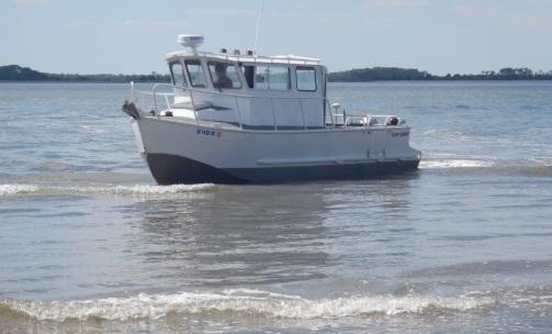
2 Coastal Science & Engineering CSE founded in 1984 Most SC nourishment and groin experience of any private group Completed over 40 nourishment projects since the 1980s. Major projects at Myrtle Beach, Seabrook, Hunting, Edisto, Kiawah, Folly, Bogue Banks (NC), Nags Head (NC). Services include coastal erosion assessments, project design and management, coastal structures, permitting, data collection, coastal process modeling, CADD. Was involved in initial studies of Kiawah to develop construction setback lines. Engineered and monitored 2006 and 2015 east end projects. 3/7/2017 2
 Developed after studies of the beach processes completed 3/8/17")
3 Kiawah Island ~10 miles of beach along a mostly eastwest configuration Stono Inlet to east, Captain Sams Inlet to west Most of the island has accreted over past several decades (1-10 ft/yr) Developed after studies of the beach processes completed 3/8/17 3


4 Shoal Bypassing at Stono Inlet 3/8/17 4

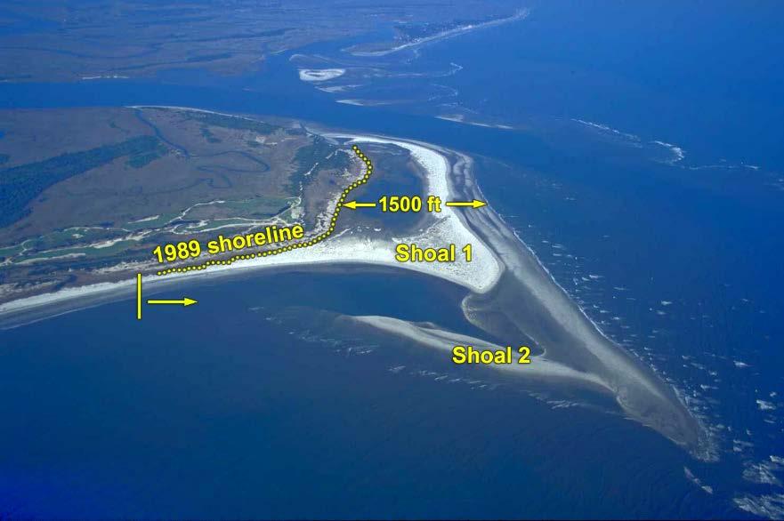


5 Large-scale shoal bypassing s Beach 1960s Beach Flushing Channel /8/17 5


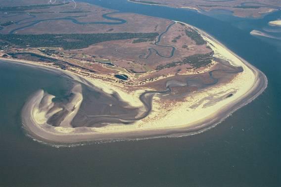
6 2006 Restoration Project Moved ~550,000 cy Inlet realignment plus beach restoration Used land-based equipment 3/8/17 6
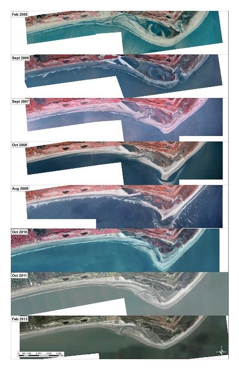

7 Post-Project Monitoring 3/8/17 7


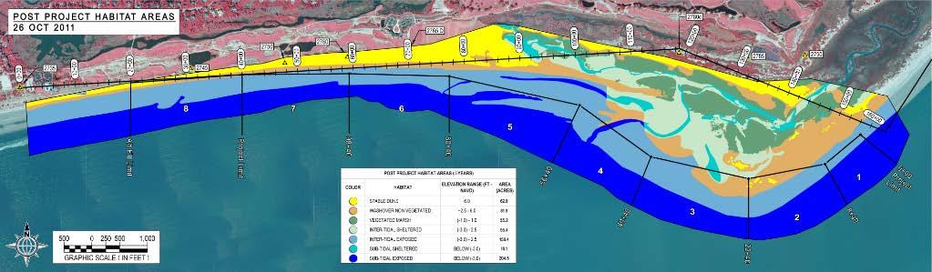
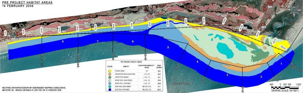
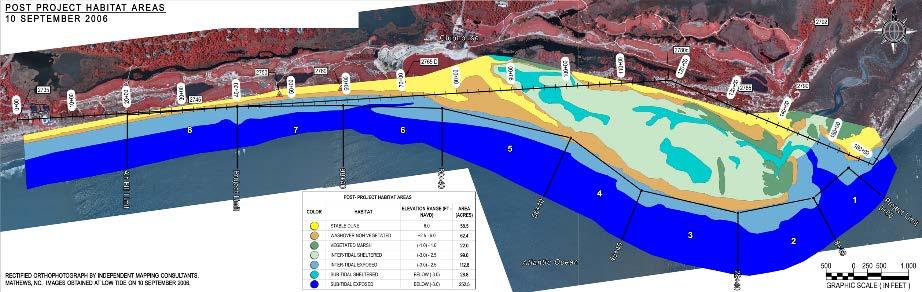
8 Habitat Areas A Dune B Washover C S. Intertidal D S. Subtidal E Vegetated Marsh F* - E. Intertidal G* - E. Subtidal


9 2015 Project 3/8/17 9


10 2015 Channel Realignment Project Moved 100,000 cy Limited beach restoration Focus on habitat conservation 3/8/17 10

11 Kiawah Island Beach Monitoring Stations 3/8/17 11
12 Key Events Channel Realignment Projects Spring 2015 Hurricane Joaquin October Survey November Hurricane Matthew October Survey Jan 2017 (delayed for environmental monitoring) 3/8/17 12
13 Hurricane Matthew Impacts Matthew impacted the beach around 8 October 2016 as a weak Category 2 storm. Winds in Charleston ~75 mph. Approached on falling tide Resulted in significant dune recession, damaged walkovers, minor flooding Storm profile vs natural profile 3/8/17 13
14 Dune Erosion During Matthew 3/8/17 14


15 Post-Storm Conditions Ocean Course Eugenia Ave 3/8/17 15


16 Post-Storm Conditions 3/8/17 16
17 Volume Changes Reach Name Unit Volume Change Total Volume Change Average 1 Kiawah Spit* , / West Beach , Turtle Point , Ocean Course , Lagoon , Stono Inlet , All , ~750,000 cy were lost due to relocation of Captain Sams Inlet in Accounting for this results in the net change of 0.1 cy/ft per year. 3/8/17 17
18 Volume Changes Overall the island lost ~850,000 cy of sand ~Half lost from east end and half from downcoast areas Residential zone lost ~330,000, which is 2-3 years worth of typical accretion Erosion most severe between Mariners Watch and Turtle Point #14. 3/8/17 18

19 Beach Recovery Calm weather promotes beach recovery. Sand moves from underwater bars to the dry sand berm and dune. Sand lost from system needs to be replaced by new sand from upcoast. Evidence of recovery in Jan 2017 and even more in Feb Recovering dunes have wind-blown accumulations at the base and spreading sparse vegetation, dry sand seaward of dune toe. 3/8/17 19

20 Post Storm and January 2017 Conditions Ocean Course 3/8/17 20

21 Post Storm and January 2017 Conditions Turtle Point 3/8/17 21

22 Post Storm and January 2017 Conditions Eugenia Ave 3/8/17 22

23 Post Storm and January 2017 Conditions Kiawah Spit 3/8/17 23


24 East End Changes ~1,400 ft migration /8/17 24


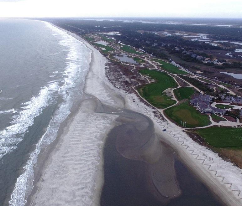

25 East End February 2017 Flushing channel Constructed Inlet New Inlet 3/8/17 25

26 East End Changes 3/8/17 26

27 Captain Sams Inlet Inlet relocated ~3,000 ft east in ,000 cy removed from new inlet basin Migrated ~325 ft from July 2015 to Jan Historical rate ft/yr End of spit is rebuilding normal shape 3/8/17 27

28 Captain Sams Inlet 3/8/17 28
29 Summary and Recommendations Overall the island lost ~850,000 cy of sand from Nov 2015 to Jan 2017, mostly due to Hurricane Matthew. Erosion was widespread. Dune erosion between 15 and 40 ft along residential area, higher along Kiawah Spit Recovery of the dune is ongoing and should be monitored by the Town No emergency action is presently recommended Should sand fence be installed, it should be placed as close to the primary dune as possible 3/8/17 29
30 Summary and Recommendations The east end project area continues to evolve Matthew opened a new channel near the 2006 channel location The ponded area near the driving range is mostly cut-off from tidal exchange, reducing erosion threat Permit allows for another project to be completed, if necessary, in /8/17 30