4.6 Site conditions General
|
|
|
- Benedict Collins
- 5 years ago
- Views:
Transcription
1 4.6 Site conditions General The Project site is located approximately 150km northwest from Dhaka, adjacent to north boundary of the existing Bheramara Thermal Power Plant approximately 20km northwest from Kushtia City, in the Khulna administrative division of western Bangladesh. Normally the climate of the Bheramara area is said to be broadly classified into four seasons; winter from December to February, summer from March to May, the monsoon season from June to September, and autumn from October to November. Winter a relatively dry season with little rain, having an average temperature of about 20 C. In summer, the whole country is covered with a tropical cyclone and much rainfall, and the temperature rises to a level of 20 C to 30 C Site Location The Project site is officially situated in Bahirchar union, Bheramara upazila, Kushtia district in the Khulna administrative division of western Bangladesh as shown in the Figure I In Bahirchar Union, the site is situated in the right bank of Padma River, approximately 400m east from the bank, and approximately 600m north from the Pump Station of G.K. (Ganges - Kobadak) Irrigation Project. The site is also situated approximately 1.8km south from Hardinge Bridge (rail way)/lalon Shah Bridge (road) and approximately 350m east from the Bheramara Bypass Road toward Kushtia City. Farmland is laid between the Bypass and the site. I-4-26

2 Location Bheramara CCPP of Figure I Project Site Location Site Planning As shown in the Figure I on the following page, the boundary separated BWDB owned area from private farm land has already been settled between BWDB and Land Office. The boundary between NWPGCL/ BPDB and BWDB has also been settled. I-4-27
3 NWPGCL/BPDB are preparing acquisition of the land located adjacent to north boundary of the existing Bheramara Power Station from BWDB, and this land acquisition will be smoothly carried out without any problem. Land acquisition for gas pipe between CGS and new Bheramara Power Station should be required. NWPGCL/BPDB is conducting coordination with Land Office and other related interested party. As shown in the Figure I-4-6-2, two (2) candidate sites of SITE-A and SITE-B are nominated for the construction of new power plant. SITE-A is situated close to north boundary of the existing Bheramara Thermal Power Plant. SITE-B is situated north east side between the existing oil tank yard and the right bank of Padma River. The comparison of 2 candidate sites is shown in the Table I Cost (Construction) (Transmission Line) (Gas Pipeline) Economical (Compensation) Technical (Area) Environment (Terrestrial Ecosystem) (Residents) Table I Comparison of 2 sites SITE-A SITE-B Base Same Connecting line to the Connecting line to the existing line is shorter. existing line is longer. Connecting line is shorter. Connecting line is longer. BWDB and BPDB property BWDB and BPDB property Land acquisition is not Land acquisition is not necessary necessary, but compensation for relocation of long term Enough area for construction, but limited free hand for site layout Base 8 families live in quarters. They are staffs of existing power station and not farmer. residents Enough area for construction, and free hand for site layout Same 72 families live on the site. Almost all of them lost houses caused by flood or something and are not farmer. (1) Evaluation from technical and economical points of view From technical point of view, there is no significant difference between SITE-A and SITE-B. However, from economical point of view, SITE-B is less efficient because compensation for relocation of the residents should be required. (2) Evaluation from Environmental point of view There is no significant difference between SITE-A and SITE-B in growth of Terrestrial Ecosystem. However, relocation of the residents should be required for SITE-B. Relocation seriously damage on livelihood of the socially vulnerable residents, who lost houses caused by flood or something. (3) Site selection SITE-A is more efficient from economical point of view, and is free from relocation of the socially vulnerable residents, which is serious issue from environmental point of view. From technical point of view, there is no significant difference between SITE-A and SITE-B, therefore, SITE-A was selected for the construction site. I-4-28
4 Padma River SITE-B Irrigation Canal : Existing Plant Boundary :BWDB Boundary :CGS Boundary SITE-A Bheramara Bypath Figure I Site Boundary I-4-29
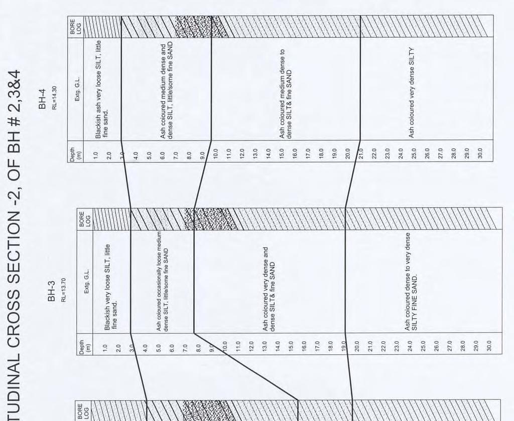
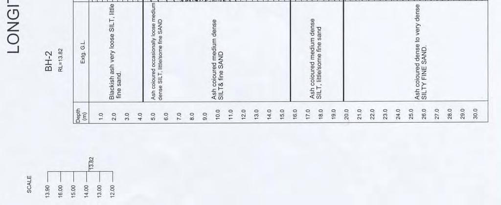
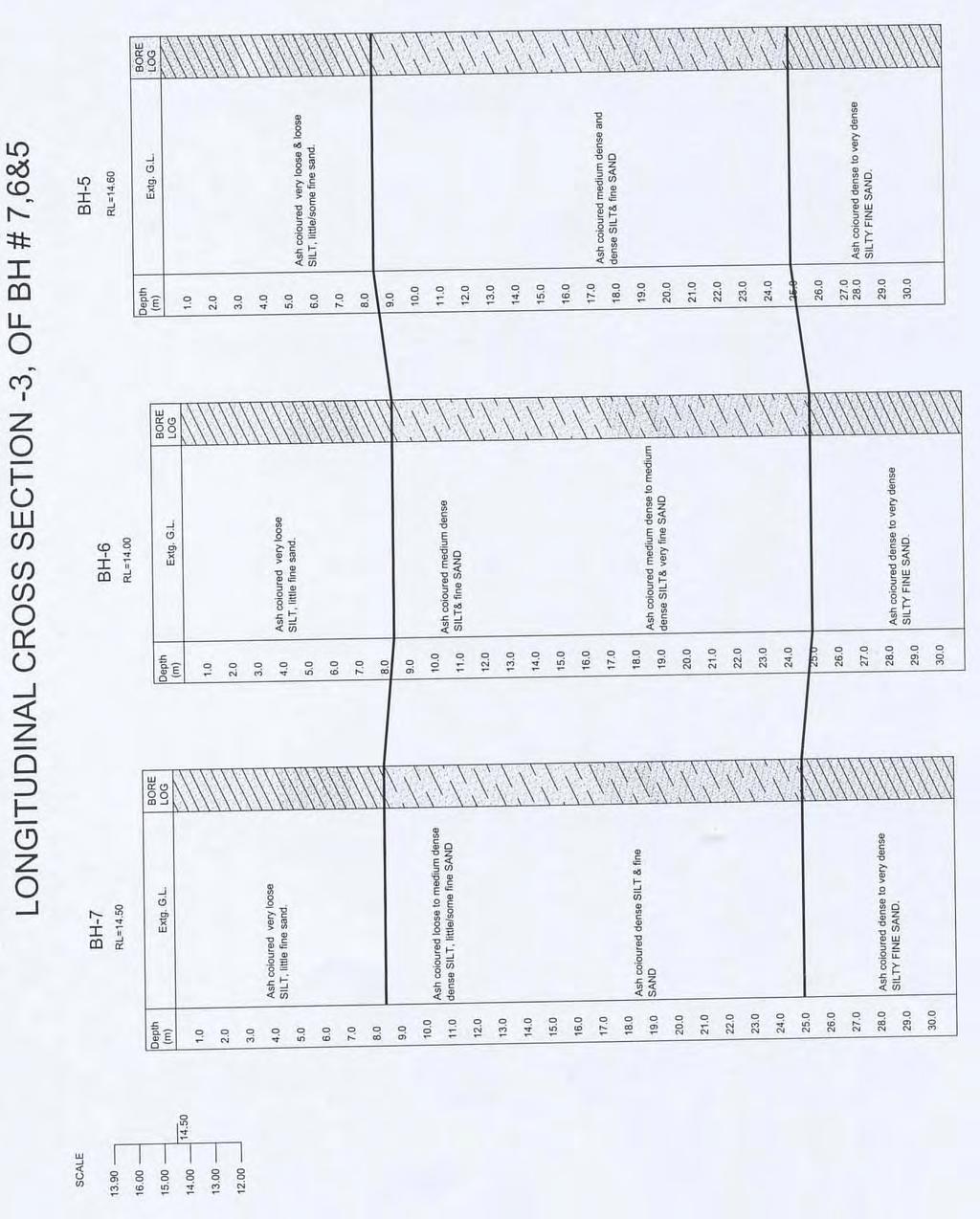
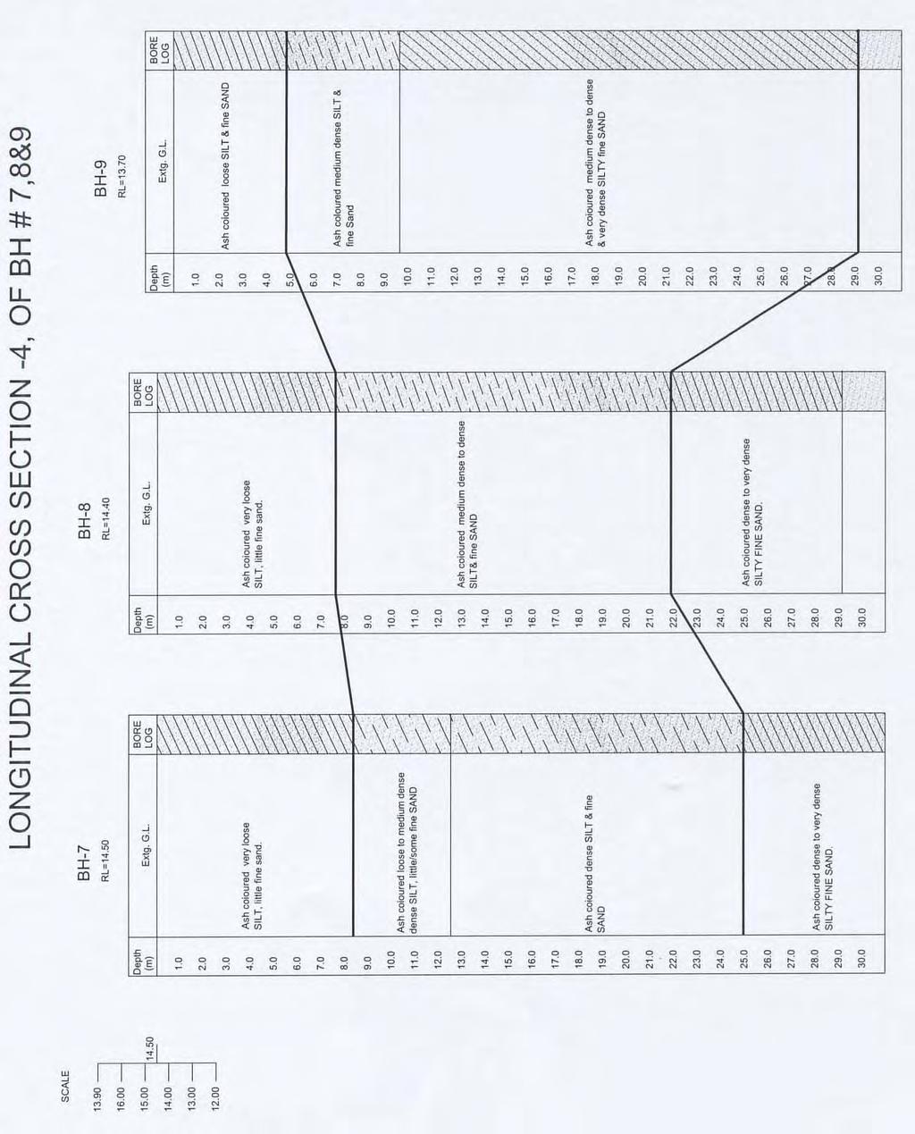
5 4.6.4 Topography and Soil Conditions (1) Topographic Survey Topographic survey has been conducted and the topographic map of Bheramara Power Station Area has been completed as drawing Topographic Map of Bheramra Power Station Area in ATTACHMENT 2. The existing buildings, structures and the boundary of NWPGCL s owned premise are shown in the above drawing. Surveyed ground levels are following; Existing power station area: approximately between EL+15.1m and EL+15.9m Surrounding farmland: approximately between EL+13.0m and EL+13.8m Toward the bank of Padma River: approximately between EL+13.7m and EL+14.5m (2) Soil Conditions The project area is situated in the western part of the Bengal Fore deep, which is surrounded on its north by the Shilling Plateau in Assam in India and on its west side by the Rajmahal Hills in India. The eastern limits of the Bengal Fore deep are the Tripura Hills to the east and the Chittagong Hills to the south- east. The Bengal Fore deep is floored with Quaternary sediments deposited by the rivers of the Ganges (Padma), Brahammaputra (Jamuna), the Meghna and their numerous associated streams and distributaries. The Bengal Basin is subsiding owing mainly to compaction of the recent sediments and is possibly due to structural down warping. Soil investigation has been conducted to obtain soil properties for foundation design. Regarding the subsoil formation of the project area, soil conditions are concluded as followings. 1) The layers of soil have been found regular in between the Boreholes. 2) The entire sub soil formation of the project site, through out up to the depth of the investigation, is of non-plastic nature. 3) These non-plastic soil comprises silty soil, sand-silt mix and finally silty fine sand up to the depth of the investigation. 4) The top layer of the non-plastic silty soil, extending roughly to the depth of 3.0m/4.0m (BH-1, BH-2, BH-3 & BH-4), 5.0m (BH-4) to 8.0m (BH-5, BH-6, BH-7 & BH-8) generally have been observed to be in a very loose to loose state. 5) Further below, the layers of the non-cohesive silty soil & sand-silt mix extending to a variable depth of 8.00m to 10.0m (BH-3, BH-5 & BH-9), 12.0m/13.0m (BH-1, BH-4, BH-6 & BH-7) to 19.0m (BH-2 & BH-8) generally have been found in a medium dense and occasionally in a loose state. 6) The subsequent deep layers of the non-cohesive sand-silt mix and silty fine sand generally have been observed in a dense and very dense state. 7) Due to the poor relative density as well as the poor bearing capacities of the investigated soils roughly up to the depth of 4.00m /5.0m (BH-1, BH-2, BH-3 & BH-4) to 7.0/8.0m (BH-5, BH-6, BH-7 & BH-8) measured from the EGL, the shallow foundations are not feasible to be provided, for the existing subsoil condition. Due to non-plastic behavior and non cohesive nature of the investigated soil throughout the depth of 30.0 m, Unconfined Compression Test could have not been performed. However, the soil of the site is typical Quaternary sand sediments. The non-cohesive sand-silt mix and silty fine sand have been observed in a dense state from the depth of 20m. The power plant I-4-30
6 structures such as Power House and others could be constructed with pile foundation supported by this dense layer. Bore hole location is shown in the Figure I Figure I Borehole location map Bore logs and longitudinal cross sections are shown in the following pages. Detailed result of the soil investigation is shown in the Attachment 1 of Soil investigation report. I-4-31
7 I-4-32
8 I-4-33
9 I-4-34
10 I-4-35
11 I-4-36
12 I-4-37
13 I-4-38
14 I-4-39
15 I-4-40
16 I-4-41
17 I-4-42
18 I-4-43
19 I-4-44