TREASURE COAST REGIONAL PLANNING COUNCIL M E M O R A N D U M. To: Council Members AGENDA ITEM 10
|
|
|
- Howard Higgins
- 5 years ago
- Views:
Transcription
1 TREASURE COAST REGIONAL PLANNING COUNCIL M E M O R A N D U M To: Council Members AGENDA ITEM 10 From: Date: Subject: Staff December 9, 2016 Council Meeting Local Government Comprehensive Plan Review Draft Amendment to the Palm Beach County Comprehensive Plan Amendment No. 16-6ESR Introduction The Community Planning Act, Chapter 163, Florida Statutes, requires that the regional planning council review local government comprehensive plan amendments prior to their adoption. The regional planning council review and comments are limited to adverse effects on regional resources or facilities identified in the strategic regional policy plan (SRPP) and extrajurisdictional impacts that would be inconsistent with the comprehensive plan of any affected local government within the region. Council must provide any comments to the local government within 30 days of the receipt of the proposed amendments and must also send a copy of any comments to the state land planning agency. The amendment package from Palm Beach County contains four proposed changes to the Future Land Use (FLU) Atlas and text amendments to the FLU, Introduction and Administration, and Transportation elements and the Map Series of the comprehensive plan. Many of the text amendments are related to the proposed changes to the FLU Atlas. This report includes a summary of the proposed amendment and Council comments. Summary of Proposed Amendment A. Proposed Private Future Land Use Atlas Amendments 1. Seneca Commercial The proposed amendment is to change the FLU designation on 4.51 acres from Agricultural Reserve (AGR) to Commercial Low with an underlying Agricultural Reserve (CL/AGR) with a condition limiting development of commercial retail and office uses to a maximum of 38,538 square feet (SF). The subject property is located on the south side of Atlantic Avenue east of Lyons Road within the Agricultural Reserve Tier. The property is currently vacant. Adjacent land uses are Agricultural Reserve to the north, east and south; and Commercial Low with an underlying Agricultural Reserve in process to the west.
2 Following a series of workshops and roundtables regarding the Agricultural Reserve Tier, the Board of County Commissioners adopted changes to the comprehensive plan that included increasing the cap on commercial retail and office uses within the Agricultural Reserve Tier from 750,000 SF to 980,000 SF. The proposed amendment is one of about 10 privately proposed future land use amendment requests for Commercial in the Agricultural Reserve Tier to be considered by the county this year. The county s Traffic Engineering Division indicated the proposed amendment would result in an increase of 1,513 net daily trips and 8 AM and 138 PM net peak hour trips based on development of 43,560 SF of retail uses. The county staff report concluded the proposed amendment is compatible with surrounding land uses and there are adequate public facilities and services available to support the proposed development. The county staff report notes that the subject property is located within ¼ mile of one of the two primary commercial intersections identified in the comprehensive plan (Atlantic and Lyons), which makes this site a suitable location for additional commercial uses within the Tier. The county staff report also indicated the proposed cap of 38,538 SF of commercial retail and office uses falls within the maximum allowed in the Agricultural Reserve Tier, and the proposed amendment is consistent with Board of County Commissioners direction to allow for additional, neighborhood-serving commercial uses within the Agricultural Reserve. B. Proposed Private Text and Future Land Use Atlas Amendments 1. Southern Cleary The proposed amendment is to change the FLU designation on 1.17 acres from Industrial (IND) to Commercial High (CH) with an alternative Industrial (CH/IND). The proposed amendment also includes a text change to revise FLU Element Policy a to allow commercial designation specifically at the intersection of Southern Boulevard and Cleary Road. The subject property is located on the northwest corner of Southern Boulevard and Cleary Road within the Urban/Suburban Tier. The property is currently vacant. Adjacent land uses are Industrial to the north, east and west; Southern Boulevard and the C-51 Canal occur to the south. The applicant is proposing to develop a convenience store with gas sales on the subject property. The site is located in an industrial area and is surrounded by industrial uses on three sides. The proposed amendment would reduce the maximum potential development of the site from 22,934 SF (0.45 floor area ratio) to 17,837 SF (0.35 floor area ratio). The applicant is proposing the revision to Policy a because the subject site does not meet the location requirements for Commercial High. This policy currently does not allow commercial future land use on this site since it is not located at the intersection of a collector and arterial, or two arterial roadways, as identified on the county s Functional Classification Map. The county s Traffic Engineering Division indicated the proposed amendment would result in an increase of 2,351 net daily trips and 182 AM and 147 PM net peak hour trips 2
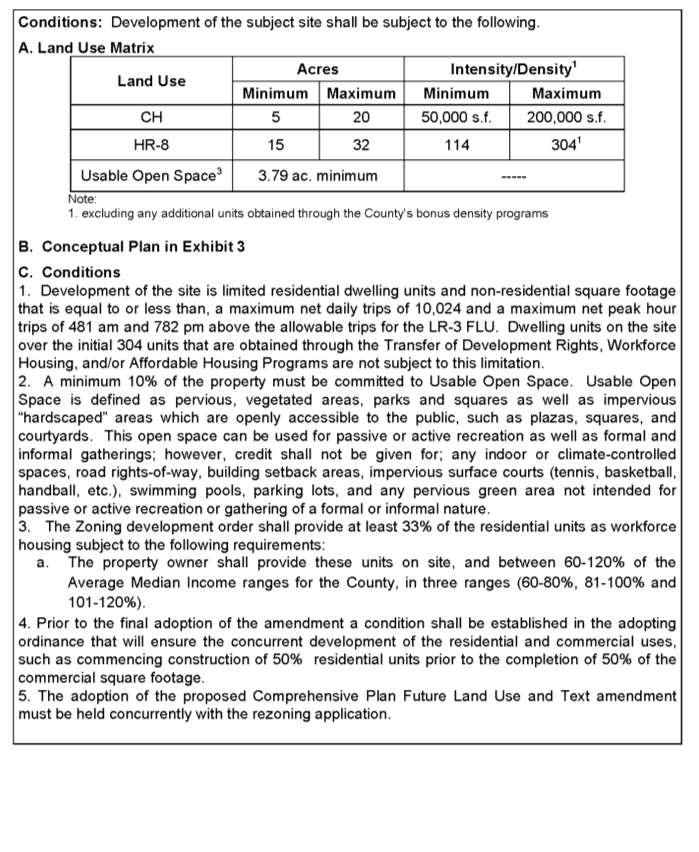
3 based on development of 17,837 SF of commercial retail uses. The county staff report concluded the proposed amendment is compatible with surrounding land uses and there are adequate public facilities and services available to support the proposed development. However, county staff recommended the proposed text and FLU Atlas and text amendment be denied, because it will allow commercial future land use designation east of the Turnpike in an otherwise industrial area and would encourage the conversion of other valuable industrial frontage on Southern Boulevard to commercial uses in this area. The county staff report indicated this is contrary to Policy a, which discourages the loss of industrially designated lands. 2. Johns Glades West MLU The proposed amendment is to change the FLU designation on acres from Low Residential, 3 units per acre (LR-3) to Multiple Land Use, with Commercial High and Residential, 8 units per acre (MLU, with CH, HR-8). The subject property is located at the southwest corner of Glades Road and 95th Avenue South in the Urban/Suburban Tier. The site has been farmed with row crops. Adjacent land uses are Medium Residential, 5 units per acre to the north and east; Commercial Low with underlying Medium Residential, 5 units per acre to the northeast; Medium Residential, 5 units per acre and Low Residential, 3 units per acre to the south; Commercial Low with underlying Low Residential, 3 units per acre to the southwest; and Commercial High with underlying Low Residential, 3 units per acre to the west. The applicant has proposed a type of entertainment and housing destination that would contribute to balancing land uses in this suburban area. A conceptual plan shows proposed areas of commercial and residential development as well as open space, private recreation, landscape buffers and pedestrian and vehicular circulation. The proposed amendment also includes the following conditions of approval: 1) development of the site is limited to residential dwelling units and non-residential square footage that is equal to or less than, a maximum net daily trips of 10,024 and a maximum net peak hour trips of 481 AM and 782 PM above the allowable trips for the Low Residential, 3 units per acre designation; 2) a minimum 10 percent of the property must be committed to usable open space; 3) the zoning development order shall provide at least 33 percent of the residential units as workforce housing; 4) a condition shall be established in the adopting ordinance that will ensure the concurrent development of the residential and commercial uses; and 5) the adoption of the proposed comprehensive plan FLU and text amendment must be held concurrently with the rezoning application. The proposed text amendment revises Policy 3.5-d to provide an exemption of the current site from the long range traffic levels of service required for development. The county s Traffic Engineering Department indicated the proposed amendment would result in an increase of 10,024 net daily trips and 481 AM and 782 PM net peak hour trips. The county staff report indicated the proposed Multiple Land Use designation with conditions of approval and Conceptual Plan demonstrates that the land uses will be functionally integrated, provide for a variety of housing in the area, be compatible with the surrounding land uses and meet all policy requirements of the Comprehensive Plan with the exception of the long range traffic requirements of Policy 3.5-d. The county staff 3
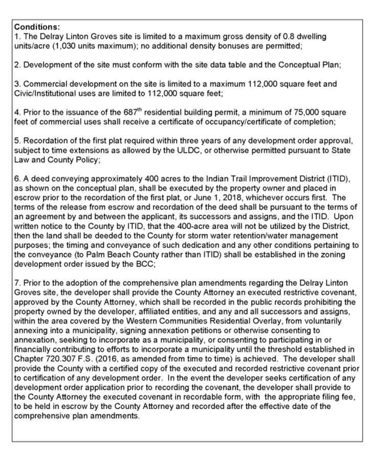
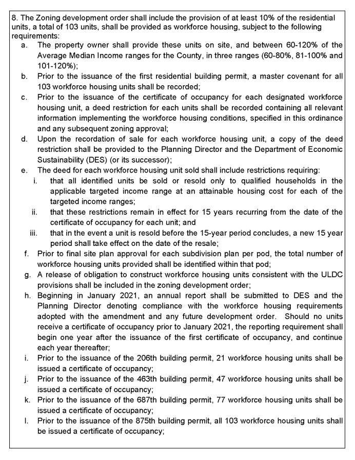
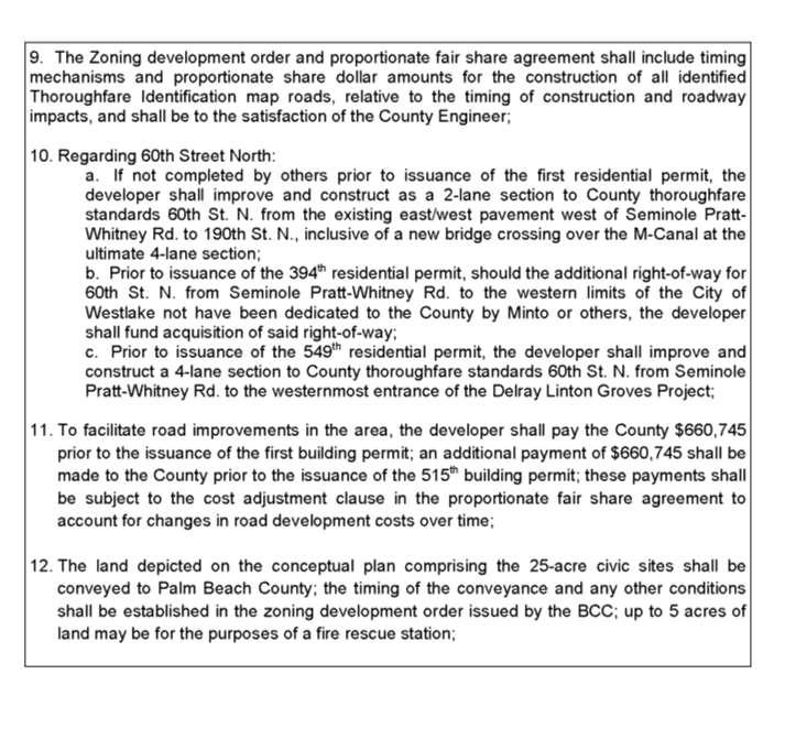
4 report indicated the conditions of approval to limit the majority of the potential traffic impacts to off peak hours, to provide additional workforce housing, to ensure that a mix of uses is established, and to require that the rezoning and amendment public hearings are held concurrently should offset any potential negative impacts associated with traffic. 3. Delray Linton Groves The proposed amendment is to change the FLU designation on 1, acres from Rural Residential, 1 unit per 10 acres (RR-10) to Western Communities Residential (WCR) with conditions of development. The proposed amendment increases the residential density from 0.1 dwelling units per acre to 0.8 dwelling units per acre. This change would result in an increase in the maximum number of dwelling units on the property from 129 units to 1,030 units, which is a 698 percent increase. The proposed amendment would also allow a maximum 112,000 SF of commercial and 112,123 SF of community uses on the property. The Delray Linton Groves (DLG) property is located west of 190 th Street North, north of 60 th Street North. The north, east, and south boundaries of the property are directly adjacent to the recently approved Indian Trails Grove property. Adjacent land uses are Western Communities Residential to the north and south; Western Communities Residential and Rural Residential, 1 unit per 5 acres to the east; and Rural Residential, 1 unit per 10 acres and Rural Residential, 1 unit per 5 acres to the west. The DLG property was cleared for citrus production in the 1960s. Currently, portions of the site are in active production of rowcrops. The site is located within an area of the county known as the Central Western Communities, a 57,000-acre area predominated by low density residential development and large tracts of undeveloped agricultural lands. It is located within the county's Rural Tier of its Managed Growth Tier System. Other projects in this general vicinity include: Minto West Agricultural Enclave. This 3,700-acre project was approved by Palm Beach County in October The project includes 4,500 residential units and 2,000,000 SF of non-residential development. On June 20, 2016, this property incorporated as the City of Westlake under the provisions of section , Florida Statutes. Avenir. This 4,800-acre project was approved by the City of Palm Beach Gardens on May 5, The project includes 3,250 residential units and 2,540,000 SF of non-residential development. Central Park Commerce Center. This 138-acre project was approved by Palm Beach County on April 27, The project includes 3,200,000 SF of light industrial and warehouse uses. Indian Trails Grove. This 4,872-acre project was approved by Palm Beach County on September 22, The project includes 3,897 residential units and 350,000 SF of non-residential development. Highland Dunes/Arden. This 1,209-acre project was approved by Palm Beach County in October, The project includes 2,000 residential units. The proposed amendment also includes revisions to the FLU and Transportation elements and Map Series. Major changes are summarized below: 4
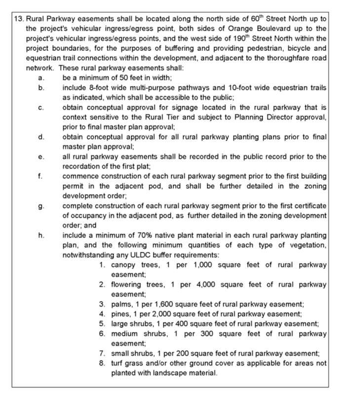
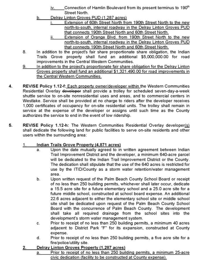
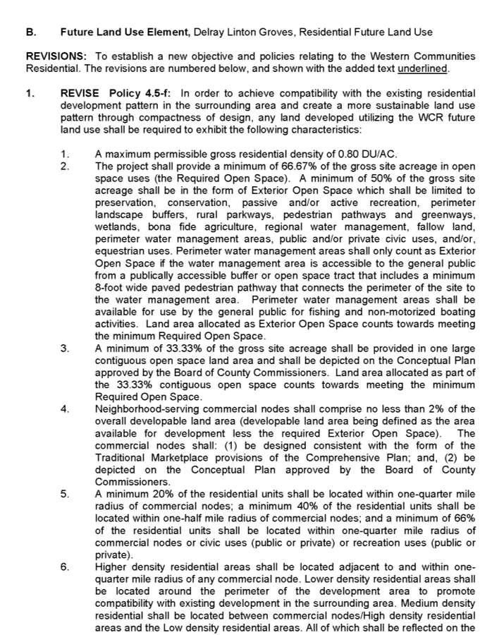
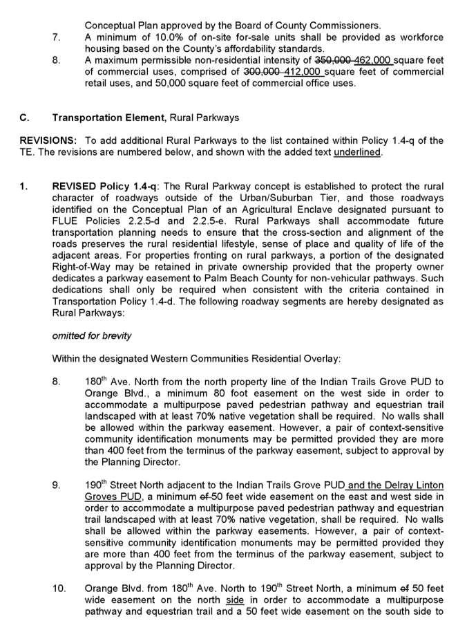
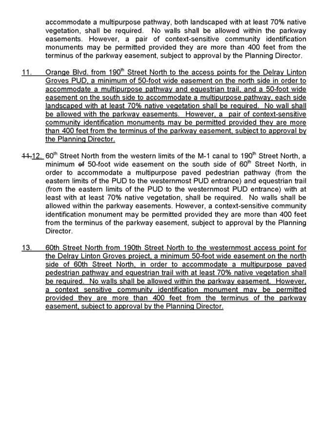
5 Future Land Use Element Revise Policy 1.12-a to indicate the Western Communities Residential Overlay consists of approximately 6,159 acres (increased from 4,871 acres). Revise Policy 1.12-c to indicate within the Western Communities Residential Overlay the maximum number of residential units shall be limited to 4,927 units (increased from 3,897 units) and the maximum amount of non-residential commercial retail uses shall be limited to 412,000 SF (increased from 300,000 SF). Revise Policy 1.12-e to indicate the developer is to provide a minimum 2.5 miles of 8-foot-wide pedestrian and bicycle pathways open to the public; provide 4 miles of equestrian trails open to the public; provide the extension of 60th Street North from 190th Street North to the new north-to-south, internal roadway in the DLG Planned Unit Development (PUD) that connects 190th Street North and 60th Street North; provide the extension of Orange Blvd. from 190th Street North to the new north-to-south, internal roadway in the DLG PUD that connects 190th Street North and 60th Street North; and, in addition to the project's proportionate fair share obligation for the DLG property, provide an additional $1,321,490 for road improvements in the Central Western Communities. Revise Policy 1.12-h to require the developer to donate 25 acres for a civic facility to be constructed at the county s expense. Revise Policy 4.5-f to indicate the Western Communities Residential land use category shall have a maximum permissible non-residential intensity of 462,000 SF (increased from 350,000 SF) of commercial uses, comprised of 412,000 SF (increased from 300,000 SF) of commercial retail uses, and 50,000 square feet of commercial office uses. Transportation Element Revise Policy 1.4-q regarding rural parkways to require Orange Boulevard from 190th Street North to the access points for the DLG PUD contain a minimum of a 50-foot wide easement on the north side in order to accommodate a multipurpose pathway and equestrian trail, and a 50-foot wide easement on the south side to accommodate a multipurpose pathway, with each side landscaped with at least 70% native vegetation. Revise Policy 1.4-q regarding rural parkways to require 60th Street North from 190th Street North to the westernmost access point for the DLG project contain a minimum 50-foot wide easement on the north side of 60th Street North in order to accommodate a multipurpose paved pedestrian pathway and equestrian trail with at least 70% native vegetation. Map Series Revise Map LU 1.1, Managed Growth Tier System Map, to add the DLG PUD to the Western Communities Residential Overlay as a Limited Urban Service Area. Revise Map LU 2.1, Service Area Map, to add the DLG PUD as a Limited Urban Service Area and remove it from the Rural Service Area. Revise Map LU 3.1, Special Planning Areas Map, to add the DLG PUD to the Western Communities Residential Overlay. 5
6 Revise Map TE 14.1, Thoroughfare Right of Way Identification Map, to extend Orange Boulevard, and 60th Street North, west of 190th Street North into the DLG PUD and add notes relative to Policy 1.4-q. The applicant for the proposed amendment has provided a conceptual plan (Exhibit 18) to be adopted as part of the proposed amendment. The conceptual plan identifies the general locations of land uses and establishes design components. The conceptual plan illustrates: One node of commercial on the eastern central portion of the project; Areas of low, medium and high density residential; Areas of civic/institutional, recreation, and open space; and Other features including ingresses and egresses, equestrian trails, and pedestrian pathways. The applicant has indicated the DLG project would provide several public benefits, including the following: Provision for 10 percent of all units to be provided on-site as workforce housing; Creation of a mixed-use community design to address regional land use imbalance and potential to reduce vehicle miles travelled; Provision of 25 acres of civic site dedications; Provision of a minimum 4 miles of equestrian trails, 6 miles of pedestrian and bicycle pathways and trails within the project; and Potential to address regional flooding through increased water storage on 400 acres of open space on the western side of the property. The county staff report indicated that the proposed amendment is generally consistent with provisions of the county s comprehensive plan. Potable water, wastewater, and reclaimed water service will be provided by the Palm Beach County Water Utilities Department, who has indicated they have the necessary capacity to provide the required level of service (LOS) at the proposed density and intensity. Drainage infrastructure and capacity will be provided by the Cypress Grove Community Development District and the property would become an active unit of the Indian Trail Improvement District. The county staff report noted that due to the location of the DLG project in the Central Western Communities, this site has an opportunity to address imbalances of land uses through additional non-residential development, provide regional water and drainage solutions for the area, and provide workforce housing. The county staff report indicated the proposed amendment would be compatible with surrounding land uses, because the proposed density is equivalent to the density in the Exurban Tier. Also, the applicant is proposing extensive buffers and separation to adjacent lands in the Rural Tier that are both in agriculture and residential development. In addition, the rural landscape will be enhanced through the incorporation of significant pedestrian, bicycle, and equestrian trails, and use of the rural parkway concept along 190 th Street North and 60 th Street North that form the boundary of the parcel. 6
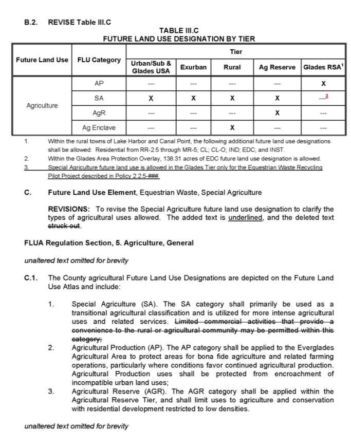
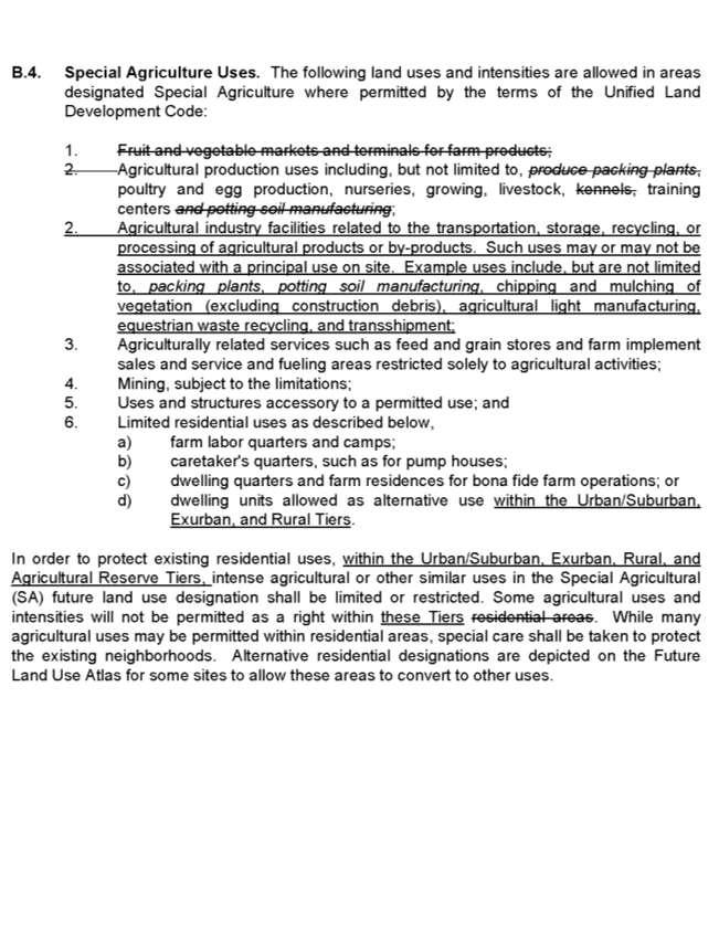
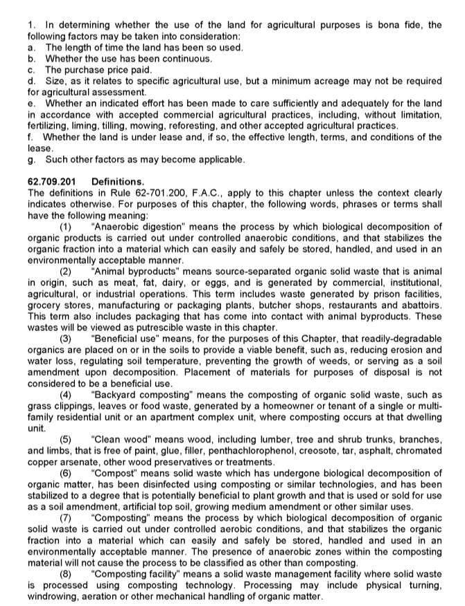
7 The county staff report indicated the proposed amendment includes an exemption from Policy 3.5-d to address impacts to roadway LOS for many facilities within central western Palm Beach County. Policy 3.5-d was adopted by the county in part to determine whether or not there would be significant potential impacts upon the transportation network based on an analysis using the Palm Beach Metropolitan Planning Organization's (PBMPO) long range transportation model. The proposed amendment is projected to generate approximately 13,375 additional daily trips on the regional road network. The long range Policy 3.5-d study showed that the proposed land use amendment does not comply with the policy. The county identified 17 segments that did not meet the adopted LOS. The county staff report indicated many of the long-term deficiencies indicated in the 3.5-d study can be effectively addressed by providing more lane and intersection capacity than what was expected in the long range model road network. C. County Initiated Amendments 1. Equestrian Waste The proposed amendment is to revise the FLU and Introduction and Administration elements to provide language to: define equestrian waste and recycling; allow an equestrian waste recycling pilot project on Special Agriculture (SA) FLU designation in the Glades Tier; and clarify the types of agricultural related uses allowed within the SA designation. The proposed amendment addresses the ongoing issue of managing equestrian waste in the county. Currently, facilities that recycle or process equestrian waste are allowed within the Industrial FLU designation, but not allowed close to the core equestrian areas of the central county. Furthermore, in recent years new technologies have been developed to address equestrian waste in a more sustainable manner through recycling. The proposed amendment addresses these issues. New definitions added to the Introduction and Administration Element include: Equestrian Waste Equestrian Waste means manure produced by horses along with soiled bedding material. Manure means a solid waste composed of excreta of animals, and residual materials that have been used for bedding, sanitary or feeding purposes for such animals. Recycling Recycling means any process by which solid waste materials are recovered and reused in manufacturing, agricultural, power production, and other processes. New Policy ## in the FLU Element allows an equestrian waste recycling pilot project to be approved in the Glades Tier Rural Service Area within the Special Agriculture future land use designation. This change is proposed as a pilot project to limit the first application of the language before considering allowing the use through this future land use on a broader scale. The Pilot Project site must meet the following criteria in order to be approved: 7
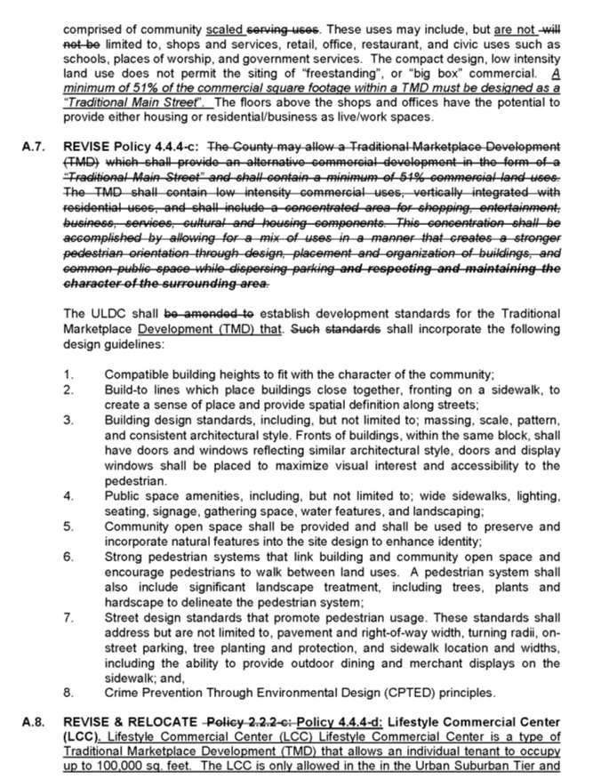
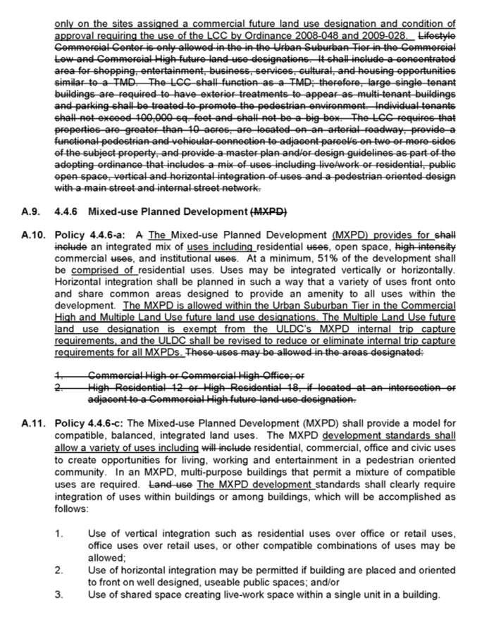
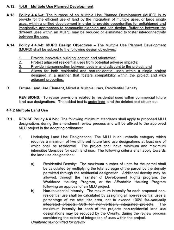
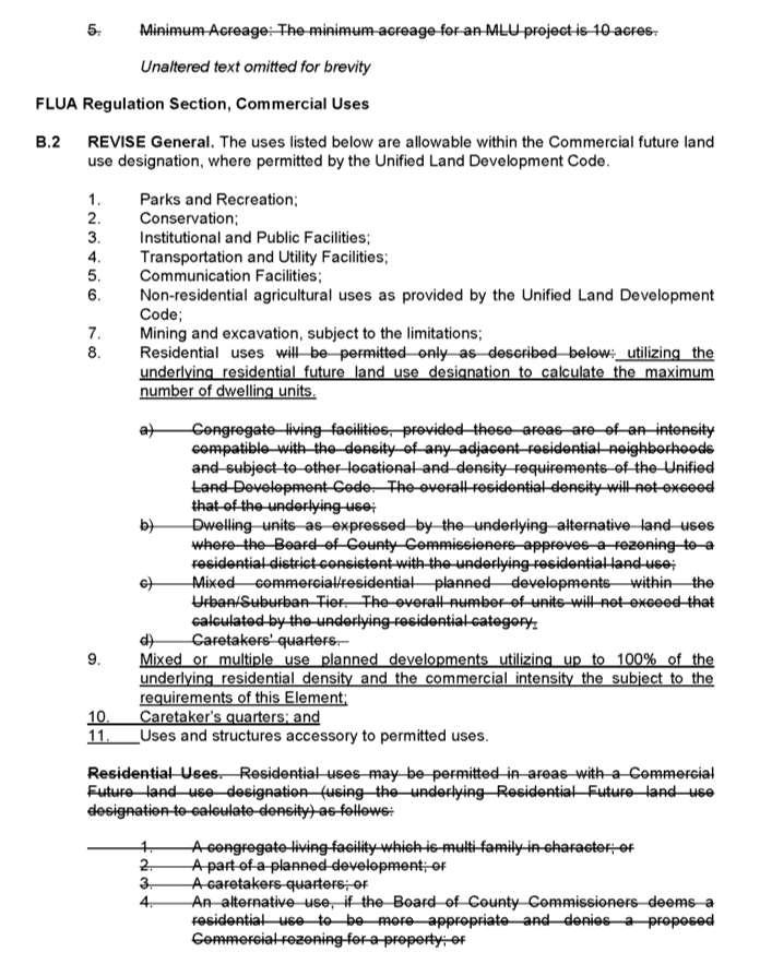
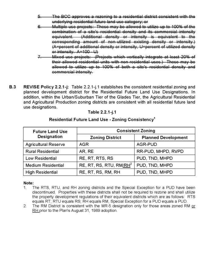
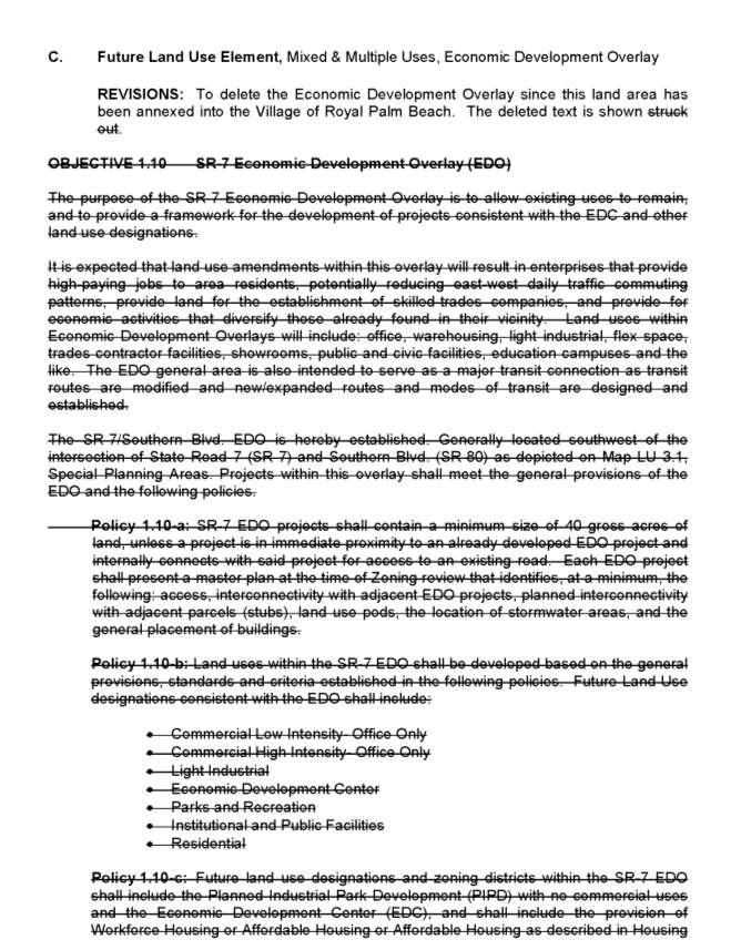
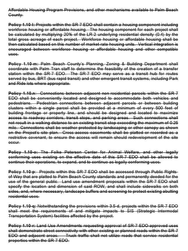
8 1. The site must be located in proximity to State or County roadways (SR80, SR715, CR880, Connors Highway/US98, Browns Farm Road, and US27) either by frontage with direct access or located within 300 feet; and 2. The site must hold a valid development order for composting approved prior to December 31, 2017; and 3. The site must be self-contained, comply with all regulatory permits, and comply with the Unified Land Development Code (ULDC) Article 5, Best Management Practices for Livestock Waste Received from Offsite Sources; and 4. The ULDC shall be revised to ensure that the use is not located within a minimum of 1,000 feet from food processing or packing plants. The FLU Element continues to indicate the Special Agriculture (SA) FLU category shall primarily be used as a transitional agricultural classification and is utilized for more intense agricultural uses and related services. However, a statement that permitted limited commercial activities in this category has been deleted. Also, the description of land uses and intensities allowed in areas designated Special Agriculture was modified by adding the following uses: Agricultural industry facilities related to the transportation, storage, recycling, or processing of agricultural products or by-products. Such uses may or may not be associated with a principal use on site. Example uses include, but are not limited to, packing plants, potting soil manufacturing, chipping and mulching of vegetation (excluding construction debris), agricultural light manufacturing, equestrian waste recycling, and transshipment. The county staff report indicated the proposed amendment is consistent with the comprehensive plan and will promote sustainable options by establishing additional opportunities for the recycling of equestrian waste in an efficient, environmentally sustainable manner. The proposed amendment will promote new management techniques offering better methods of handling the waste. These newer methods can be fully contained within structures, which have the benefits of eliminating nutrient run off and reducing water pollution, and recycle the waste into bedding material and other products that can reduce demands for raw materials. The proposed Pilot Project in the Glades Tier will provide an opportunity for this use close to the equestrian hub in Wellington, Town of Loxahatchee Groves, and the surrounding Western Communities. 2. Mixed and Multiple Use The proposed amendment is to revise the FLU Element provisions related to mixed use and multiple use projects. The purpose of this amendment is to allow greater flexibility for sites to utilize both nonresidential intensity and residential density in order to promote a more efficient and effective use of land. The amendment revises Objective 4.4 to add the term Multiple Use to the current title of Mixed Use to more accurately reflect the future land use designations and zoning designations addressed by this objective. Many of the policies under Objective 4.4 are proposed to be revised to eliminate hindrances to mixed and multiple use development and establish consistency across mixed and multiple 8
9 uses. The proposed changes include deleting the requirement for vertical integration to achieve maximum residential density and non-residential intensity; exempting Multiple Land Use future land use designation projects from the internal trip capture requirements of the Mixed-use Planned Development zoning district; eliminating redundancy; adding references to Multiple Use Planned Development; and eliminating Lifestyle Commercial Center as a freestanding zoning district. The proposed amendment also deletes Objective 1.10, SR-7 Economic Development Overlay and all of the policies under this objective, because the land area was annexed into the Village of Royal Palm Beach. Also, the proposed amendment revises Policy j and Table j.1 to clarify that the Residential High (RH) zoning district is consistent with the Medium Residential future land use designation only for those parcels that held this district prior to This language was inadvertently omitted from a previous amendment. The county staff report indicated the proposed amendment is consistent with the comprehensive plan and will foster use of the mixed and multiple use future land use designations and zoning districts by eliminating hindrances that require vertical integration and internal trip capture. The county staff report indicated that allowing infill projects to develop with multiple uses will result in a more efficient use of land and add the ability for more housing opportunities in existing urban areas. Regional Impacts Seneca Commercial: The Agricultural Reserve is recognized in the Economic Development section of the SRPP as a significant regional resource, because of its unique potential for agricultural production important for providing food resources nationally. The Agricultural Reserve provides a two billion dollar industry that produces 28 percent of the fruits and vegetables in the county, and supports many jobs. The Agricultural Reserve is approximately 22,000 acres of unincorporated land west of the Florida Turnpike and north of the Broward County line. The Agricultural Reserve was established in 1980 to facilitate preservation of agriculture. In 1998, the Board of County Commissioners directed the development of a master plan with the purpose to preserve and enhance agricultural activity and environmental and water resources in the Agricultural Reserve, and produce a master development plan compatible with these goals. In 1999, a Conservation Bond Referendum was passed with $100 million to protect property in the Agricultural Reserve. In 2001 the county s comprehensive plan was revised to incorporate the findings contained in the Agricultural Reserve Master Plan. Approximately 2,400 acres in the Agricultural Reserve were protected through the bond issue, and another 7,000 acres have been preserved for agriculture on privately owned parcels. In 2014 and 2015, the county held roundtable workshops to consider changes to the provisions of the Agricultural Reserve. In April 2016, the county amended the FLU Element to allow private future land use amendments for commercial land use to be reviewed on a case by case basis, including increasing the cap on commercial retail and office uses within the Tier from 750,000 SF to 980,000 SF. The Seneca Commercial proposed amendment includes a condition limiting development of commercial retail and office uses to a maximum of 38,538. This change is 9
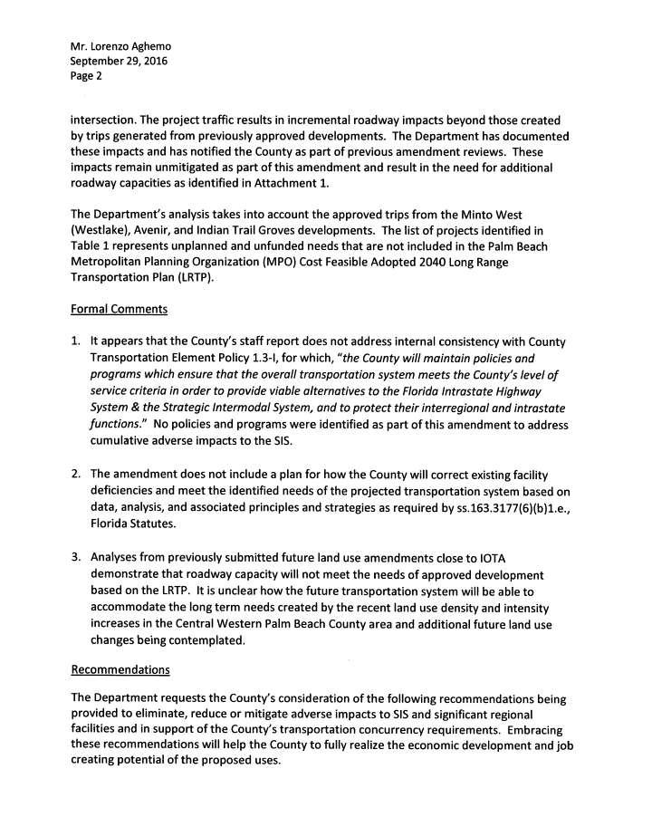
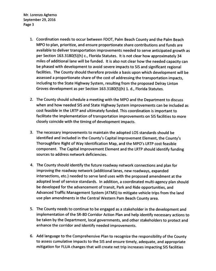
10 expected to result in the county reaching the maximum 980,000 SF of commercial development allowed in the Agricultural Reserve Tier. The Seneca Commercial proposed amendment would reduce the potential for agricultural-related uses in the Agricultural Reserve and increase commercial uses. The direct impact of the proposed amendment on the potential for agricultural production in the Agricultural Reserve is very small, because the proposed change only affects about 4.51 acres of the approximately 22,000 acres in the Agricultural Reserve. However, the overall trend in the reduction of agricultural uses in the Agricultural Reserve is of concern, because the conversions result in the loss of a regional resource that may never be recovered. Council encourages the county to take a strong position in protecting agricultural use in the Agricultural Reserve. Johns Glades West MLU: The proposed amendment has the potential to significantly impact the regional roadway network, including segments of Glades Road, SR 7, and Lyons Road. The conditions of approval to limit the majority of the potential traffic impacts to off peak hours, to provide additional workforce housing, and to ensure that a mix of uses is established, are expected to offset potential negative impacts associated with traffic impacts. However, the mitigation measures to offset potential traffic impacts resulting from providing an exemption to Policy 3.5-d could be enhanced by providing additional pedestrian and vehicular connections with adjacent properties. Delray Linton Groves: The proposed amendment has the potential to significantly impact the regional roadway network by exceeding LOS standards on segments of Seminole Pratt Whitney Road; Northlake Boulevard; Orange Boulevard; 60 th Street North; Persimmon Boulevard; and Okeechobee Boulevard. Part of the DLG proposal is to request a text amendment to Palm Beach County s comprehensive plan granting several LOS exemptions or waivers for the roadways listed above. Regional Transportation and Energy Policies , and are to encourage patterns of development and redevelopment that reduce dependency on the automobile and the use of fossil fuels; maximize public transportation alternatives; minimize the use of the region s arterial and collector network; and support requests for lower LOS in higher density areas, downtowns and along designated public transportation corridors. Under Council s SRPP, the DLG proposal is not consistent with these fundamental regional transportation and energy priorities and would not qualify for LOS or transportation concurrency exceptions. The Florida Department of Transportation (FDOT) has indicated that taking into account the approved trips from the Minto West (Westlake), Avenir, and Indian Trails Grove developments, the necessary roadway improvement projects represent unplanned and unfunded needs that are not included in the PBMPO Cost Feasible Adopted 2040 Long Range Transportation Plan (Exhibit 20). Attachment 1 of the FDOT letter identifies over 34 miles of needed roadway improvements with an estimated cost of $262,800,000. According to FDOT s analysis, addressing these roadway deficiencies will require the expansion of several sections of SR 80 (Southern Boulevard), SR 7, and Northlake Boulevard to 10 and 12 lanes. FDOT also noted that the proposed amendment does not include a plan for how the county will correct existing facility deficiencies and meet the identified needs of the projected transportation system. FDOT stated it is unclear how the future transportation system will be able to accommodate the long-term needs created by the recent land use density and intensity increases in the Central Western Communities and additional FLU changes being contemplated. 10
11 The proposed amendment is inconsistent with Regional Policies , , and , which encourage development and redevelopment of areas where adequate public facilities exist before allocating funds to support new facilities in undeveloped areas. No public services or access to this property exist today. The DLG project is expected to generate 13,275 external vehicle trips per day. However, when combined with the recently approved Indian Trails Grove project, over 55,800 new trips will be added to the regional roadway system. All access to both of these projects will be from neighborhood streets, which serve the surrounding rural residential communities. Palm Beach County is having difficulty maintaining the integrity of its current countywide infrastructure investments and contains dozens of distressed neighborhoods and districts where public services and facilities already exist, but need updating. There is a concern that opening up more undeveloped land and providing new urban services will make it more difficult for the county to make the public infrastructure investments needed to support existing development in the county. The proposed amendment is inconsistent with Regional Redevelopment Goal 5.1, which prioritizes the redevelopment, revitalization and infill of existing neighborhoods and districts; Regional Strategy 5.1.1, which is to identify and improve distressed and underutilized neighborhoods and districts; and Regional Policy encourages redevelopment of existing urban areas to discourage sprawl. The proposed amendment does not further these fundamental regional priorities for growth and development of the region. There is concern the DLG proposal will further reduce the county s capacity to address other areas in the county in significant need of redevelopment and infrastructure improvements. The proposed amendment is inconsistent with Regional Economic Development Goals 3.1, 3.2 and 3.4, which encourage patterns of development and public investment to: 1) improve economic and redevelopment opportunities for distressed communities; and 2) support a sufficient agricultural land base to increase the sustainability, expansion and diversification of agricultural activities throughout the region. More specifically, the DLG proposal is inconsistent with Regional Economic Development Policies , and , which are to discourage suburban sprawl and encourage sustainable economic development by giving high priority to working with the private sector and coordinating land use planning that will increase public investment and assistance to foster infill, redevelopment and refurbishing of infrastructure in existing urban areas. The proposed amendment is inconsistent with Regional Housing Goals 2.3 and 2.5, which encourage stabilization and revitalization of existing neighborhoods and future growth that does not result in isolated patterns of development. The main reason for this is to encourage an ample mix of affordable rental and for-sale housing opportunities in close proximity to established employment centers, public services, and existing transportation and public transit corridors that provide good access to jobs. This is an important aspect of reducing the transportation cost burden of accessing employment and other services on the individuals and families who can least afford it. The DLG proposal includes a commitment that 10 percent of on-site, for-sale units will be provided as workforce housing based on the county s affordability standards. The isolated nature of this project and speculation that a job base will develop in close proximity over time dilutes the value of this location as affordable housing stock for the county. The additional time and transportation costs that may result will offset any savings to individuals and families purchasing these units at a lower price point. 11
12 Extrajurisdictional Impacts Combined, the DLG and the Indian Trails Grove projects are expected to add about 55,800 net daily trips to the roadway. The traffic analysis by the Palm Beach County Traffic Division suggest roads within or adjacent to several nearby local government jurisdictions will be impacted by the proposed amendment. These include impacts to a segment of Seminole Pratt Whitney Road in the City of Westlake, and segments of Okeechobee Boulevard in the Town of Loxahatchee Groves. Traffic from the proposed amendment is also expected to impact LOS on Northlake Boulevard adjacent to the City of Palm Beach Gardens, Okeechobee Boulevard adjacent to the Village of Royal Palm Beach, and Seminole Pratt Whitney Road adjacent to the Village of Wellington. Conclusion Regarding Southern Cleary, Equestrian Waste, and Mixed and Multiple Use proposed amendments, no adverse effects on regional resources or facilities and no extrajurisdictional impacts have been identified. Regarding Seneca Commercial, the proposed amendment would reduce the potential for agricultural-related uses in the Agricultural Reserve. Council encourages the county to take a strong position in protecting agricultural use in the Agricultural Reserve. Regarding Johns Glades West MLU, the proposed amendment has the potential to significantly impact the regional roadway network, including segments of Glades Road, SR 7, and Lyons Road. Council encourages the county to consider providing additional pedestrian and vehicular connections with adjacent properties as a mitigation measure to offset potential traffic impacts. Regarding Delray Linton Groves, the proposed amendment is inconsistent with several goals and policies of Council s SRPP related to transportation, energy, economic development, housing, and redevelopment. Of particular concern is the proposed amendment is expected to result in significant adverse impacts to the regional roadway network, including Seminole Pratt Whitney Road; Northlake Boulevard; Orange Boulevard; 60 th Street North; Persimmon Boulevard; and Okeechobee Boulevard. Council is concerned that the attempt to balance land uses and obtain other public benefits, including the provision of recreational amenities, potential regional drainage solutions, and retaining some agriculture, will occur at a disproportionate and unmitigated expense to the regional roadway network. This has the potential to adversely impact the quality of life in the Central Western Communities in future years. The county should abandon the Delray Linton Groves plan amendment, because: 1) it will exacerbate existing traffic problems; 2) it will add to the backlog of roadway improvements already needed; and 3) there is no plan for how to correct existing facility deficiencies and meet the identified needs of the future transportation system. 12
13 Recommendation Council should approve this report and authorize its transmittal to Palm Beach County and the Florida Department of Economic Opportunity. Attachments 13
14 List of Exhibits Exhibit 1 General Location Map 2 Seneca Commercial Aerial Map 3 Seneca Commercial Location Map and Conditions 4 Southern Cleary Aerial Map 5 Southern Cleary Location Map 6 Southern Cleary Text Changes Showing Strikethrough and Underline 7 Johns Glades West MLU Aerial Map 8 Johns Glades West MLU Location Map and Conditions 9 Johns Glades West MLU Text Changes Showing Strikethrough and Underline 10 Johns Glades West MLU Conceptual Plan 11 Delray Linton Groves Aerial Map 12 Delray Linton Groves Location Map and Conditions 13 Delray Linton Groves Text Changes Showing Strikethrough and Underline 14 Delray Linton Groves Managed Growth Tier System Map 15 Delray Linton Groves Service Area Map 16 Delray Linton Groves Special Planning Areas Map 17 Delray Linton Groves Thoroughfare Right of Way Identification Map 18 Delray Linton Groves Conceptual Plan 19 Delray Linton Groves Indian Trails Grove Conceptual Plan 20 Delray Linton Groves FDOT Letter 21 Equestrian Waste Text Changes Showing Strikethrough and Underline 22 Equestrian Waste Florida Statute & Rule Definitions 23 Mixed and Multiple Uses Text Changes Showing Strikethrough and Underline

15 Delray Linton Groves Southern Cleary Seneca Commercial Johns Glades West MLU Exhibit 1 General Location Map 15

16 Exhibit 2 Seneca Commercial Aerial Map 16

17 Exhibit 3 Seneca Commercial Location Map and Conditions 17

18 Exhibit 4 Southern Cleary Aerial Map 18

19 Exhibit 5 Southern Cleary Location Map 19

20 Exhibit 6 Southern Cleary - Text Changes Showing Strikethrough and Underline 20

21 Exhibit 7 Johns Glades West MLU Aerial Map 21

22 Exhibit 8 Johns Glades West MLU Location Map and Conditions 22
23 23

24 Exhibit 9 Johns Glades West MLU Text Changes Showing Strikethrough and Underline 24

25 25

26 Exhibit 10 Johns Glades West MLU Conceptual Plan 26

27 Exhibit 11 Delray Linton Groves Aerial Map 27

28 Exhibit 12 Delray Linton Groves Location Map and Conditions 28
29 29
30 30
31 31
32 32

33 Exhibit 13 Delray Linton Groves Text Changes Showing Strikethrough and Underline 33
34 34
35 35
36 36
37 37

38 Exhibit 14 Delray Linton Groves Managed Growth Tier System Map 38

39 Exhibit 15 Delray Linton Groves Service Area Map 39

40 Exhibit 16 Delray Linton Groves Special Planning Areas Map 40
41 Exhibit 17 Delray Linton Groves Thoroughfare Right of Way Identification Map 41

42 Exhibit 18 Delray Linton Groves Conceptual Plan 42

43 Exhibit 19 Delray Linton Groves Indian Trails Grove Conceptual Plan 43

44 Exhibit 20 Delray Linton Groves FDOT Letter 44
45 45
46 46
47 47

48 48

49 Exhibit 21 Equestrian Waste Text Changes Showing Strikethrough and Underline 49
50 50
51 51

52 Exhibit 22 Equestrian Waste Florida Statute & Rule Definitions 52
53 53
54 54
55 55

56 Exhibit 23 Mixed and Multiple Uses Text Changes Showing Strikethrough and Underline 56
57 57
58 58
59 59
60 60
61 61
62 62

63 63
64 64