Summary of Preliminary Study Result for Grant Aid Project. Date: 2008/02/12
|
|
|
- Anna Shields
- 5 years ago
- Views:
Transcription
1 Summary of Preliminary Study Result for Grant Aid Project Date: 2008/02/12 1. Title of the Cooperation Project, Relevant Project Report The Project for Construction of Bridges in the Province of Nusa Tenggara Barat (Phase 2) Project Activity: Reconstruction of 16Brideges and 1 Culvert on the provincial road 2. Categorization and its reason Category B Reasons a) The degree of impacts resulting from the project is not significant on the social and natural environmental areas due to the small scale reconstruction of bridges and culverts required on the existing provincial road. The Indonesian EIA law prescripts that full scale EIA is not required for bridges not longer than 500 meters. However, an IEE level (UKL+UPL) report, and an approval procedure by the provincial environmental management agency (BAPEDALDA-NTB), are both required before construction stage. b) With regard to social matters, permanent and temporary land acquisition must be caused by reconstruction structures at the BR34 and BR35. Although the Indonesian government [Ministry of Public Works (PU)] has an appropriate law as well as procedures for compensation, the Japan s Government should monitor a negotiation between land owners and the plan proponent (Ministry of Public Works). Furthermore, the Indonesian procedure does not include any system of public involvement. Hence the proponent in cooperation with the JICA Study Team should hold a stakeholder meeting for consensus building in the basic design from the view of JICA s environmental and social consideration guidelines. c) With regard to natural environment issues, no sensitive or protected areas are located in the project site.

 Project site is")

2 3. Outline of the Location (Maps, Environmental and Social Condition, Problems and so on) Project site is located in the Sumbawa Island as follows. Figure-1 Project Location


3 Mountainous Area (except transmigrated Area) 0-45km Section Figure-2 Detailed Project Location Map Flat Area 45-60km Sec. <Summary of project site is as follows> - Project area is located in West Sumbawa and Sumbawa district. -Total population in the project site is approximately 25,000.(see following table) Name of District West Sumbawa/ Sekongkang Sumbawa/ Lunyuk Table-1 Population of Project Site Name of Village Population Household Remarks Secongkang Bawah 1, Sekongkang Atas 2, Tongo 1, Ari Kangkung Including independent transmigrated village Tatar Including independent transmigrated village Talonanga 1, Current Transmigrated village: Tongo II SP2 Planned Transmigrated village: Batu Nampar Lunyuk Rea 1, Lunyuk Ode 1, Jamu 1, Including independent transmigrated village Pada Suka 3, Planned Transmigrated village:lamar Suaka Maju 3, Including independent transmigrated village Perung 2, Including independent transmigrated village Emang Lestari 3, Including independent transmigrated village Total 24,729 6,270 - Source:Lunyuk/Sekongkang government 2006(BPS)
4 4. Legal Framework of Environmental and Social Considerations (Law, Projects subject to EIA, Procedures, Information Disclosure and Stakeholder Participation) a) Relevant Law for EIA / Environmental Permission Name of Law: -Law No. 23 of 1997 Environmental Management -Government Regulation No. 27 of 1999 on Environmental Impact Assessment - Decree of State Ministry for the Environment No. 17 of 2001 on Types of Business and/or Activity Plans that are required to be completed with the Environmental Impact Assessment - Decree of State Ministry for the Environment No.11 of 2006 on Types of Business and/or Activity Plans that are Required to be Completed with the Environmental Impact Assessment b) Criteria of the full scale EIA and IEE Table -2 Criteria for a full scale of EIA/ IEE Category Laws Requirement of full scale EIA Requirement of IEE level UKL+UPL Decree of state Ministry of Env. No.11/2006 Decree of state Ministry of Public Works No.17/2003 Bridge Length>=500m - Propose from proponent to authority (NTB-BAPEDALDA) Major Town (50, ,000) :Bridge Length>=60m Medium Town(20, ,000) :Bridge Length>=20m According to the environmental management agency (NTB-BAPEDALDA), EIA category issues will be screened generally based on the proposal report from the proponent. However, the person in charge of the EIA section NTB-BAPEDALDA commented that only an IEE level report (UKL+UPL) will be required. This is because the degree of impact resulting from the project must be limited, and it will not be significant for social and natural environment issues. An IEE level (UKL+UPL) procedure is shown in the figure below.

.")
")
5 Figure-2 Procedures of Environmental Permission (UKL+UPL) 5. Outline of Relevant Agency and Institution which implement Project, EIA and so on Proponent of this project is the Ministry of Public Works (PU). The organization chart of PU is as follows. Figure-3 Organization Chart of PU (Ministry of Public Works) *Note) PU has EIA section under the planning section ( )
6 On the other hand, the environmental organization whose permission for this project is required is the NTB provincial environmental management agency (NTB-BAPEDALDA). This is so because the project site is located in more than two districts, West Sumbawa and Sumbawa. Figure-4 Section in charge of Environmental Permission 6. Outline of the Project, Analysis of Alternatives (Proposed Project, Comparative Examination of Alternatives, Selected Project on the basis of the Preliminary Study) a)outline of the Project Reconstruction of 16 bridges and 1 culvert (see Table-4: Target Bridges and Culverts) b)analysis of Alternatives Basically, the alternative-1 will be adopted from the view of social and natural considerations (exception made of BR34 and BR35). Table-3 Analysis of Alternatives Physical Impact to the Social area Impact to the Impact to the Remarks Alternatives Natural area Pollution Without Project (Option Zero) It is impossible to cross rivers in the project site as no structures are available. Most of villagers will not be able to take emergency medical services. Logistics without transportation will be formulated by the self-sufficient community. No impact resulting from the project No impact resulting from the project -
7 Physical Alternatives With Project Alternatuve-1 Reconstruction of the BR. and Culvert at the same location With Project Alternative-2 (Reconstruction at the up/down stream) Impact to the Social area Land acquisition must be avoided Permanent / temporary land acquisition will be caused at some points. Impact to the Natural area Small impact resulting from the project due to the same alignment of access road. A certain level of deforest will be caused by changing alignment of access road. Impact to the Pollution Turbidity water will be caused by the construction activity (cutting land/drilling) during construction stage Turbidity water will be caused by the construction activity (cutting land/drilling) during construction stage Remarks Disadvantage on the cost and time because current sound causeways will not be used as diversion means Advantage on the cost and time because current sound causeways will be used as diversion
8 Table-4 List of Target Bridges and Culverts Bridge List Requested by Indonesia Result of Reconnaissance by JICA Preliminary Study Team Bridge No. Bridge Name Bridge Location (Sub-District) Estimated Length of Bridge (m) E x isting Struc t ure Recommendation Structure Type Bridge Length (m) JAPAN/ INDONESIA BR-1 Air Keruh Ⅰ Sekongkang 30 Gabion Bridge 30 JAPAN BR-2 Air Keruh Ⅱ Sekongkang 30 Gabion Bridge 30 JAPAN BR-3 NegeneⅠ Sekongkang 25 Gabion (Damaged) Bridge 30 JAPAN Detour at Upstream River Bed BR-4 Negene Ⅱ Sekongkang 10 Gabion Box Culvert - INDONESIA BR-5 Tatar Ⅰ Sekongkang INDONESIA Alignment Improvement of Cut Stretch (Steep G BR-6 Tatar Ⅱ Sekongkang Missing BR-7 Tatar Ⅲ Sekongkang 15 Rock Placing Box Culvert - INDONESIA BR-8 Tatar Loka Sekongkang 60 Gabion Bridge 50 JAPAN BR-9 Tatar Bodo Sekongkang 25 Gabion Bridge 25 JAPAN BR-10 Labihe Ⅰ Sekongkang 20 Gabion Box Culvert - JAPAN BR-11 Labihe Ⅱ Sekongkang 20 Gabion (Damaged) Bridge 20 JAPAN Detour at Upstream River Bed BR-12 Labihe Ⅲ Sekongkang 20 Gabion Bridge 25 JAPAN BR-13 Mone Ⅰ Sekongkang Missing BR-14 Mone Ⅱ Sekongkang Missing BR-15 Mone Ⅲ Sekongkang Missing BR-16 Telonang Ⅰ Sekongkang 30 - Bridge 30 JAPAN Crossing at Shallow Water Stream BR-17 Telonang Ⅱ Sekongkang 15 Wooden Bridge (Damaged) Bridge 10 INDONESIA Bridge Name : Batu Nampar, Remaining of Bot BR-18 Telonang Ⅲ Sekongkang 10 Wooden Bridge (Damaged) Bridge 10 INDONESIA Decay of Wooden Parts, Detour at Downstream BR-19 Sepang Lunyuk 40 Concrete Cause Way Bridge 35 JAPAN Existing Structure Completion in 2007 BR-20 Bontong Lunyuk 20 Wooden Bridge (Damaged) Bridge 20 JAPAN Collapse of Old Bridge, Detour at Upstream Riv BR-21 Bon Jati Lunyuk 10 Wooden Bridge (Damaged) Bridge 10 INDONESIA Collapse of Old Bridge, Detour at Upstream Riv BR-22 Blengkon Lunyuk Missing BR-23 Tebil Lunyuk 20 - Bridge 20 JAPAN Crossing at Shallow Water Stream BR-24 Momil Ⅰ Lunyuk 10 - Box Culvert - INDONESIA Bridge Name : Granta BR-25 Momil Ⅱ Lunyuk 30 RC Bridge (New) - - L=10m, W=7.5m, Superstructure: 6 - I Beams, BR-26 Krikit Lunyuk 15 Under Construction - - INDONESIA L=10m. Completion of Abutments, BR-25 locat BR-27 Lamar Lunyuk 40 Concrete Cause Way Bridge 40 JAPAN Existing Structure Completion in 2007 BR-28 Aikmad Lunyuk 15 - Box Culvert - INDONESIA BR-29 Liang Bagik Lunyuk 20 Concrete Cause Way Bridge 20 JAPAN Existing Structure Completion in 2007 BR-30 Petain I Lunyuk 15 Concrete Cause Way Bridge 20 JAPAN Existing Structure Completion in 2007 BR-31 Petain II Lunyuk 15 Concrete Cause Way Bridge 15 INDONESIA Existing Structure Completion in 2007 BR-32 Petain III Lunyuk Missing BR-33 Molong Lunyuk Missing BR-34 Emang Lunyuk 30 Concrete Cause Way Bridge 30 JAPAN Existing Structure Completion in 2007 BR-35 Kalbir Lunyuk 20 Concrete Cause Way Bridge 20 JAPAN Existing Structure Completion in 2007 Nos. of Bridge : 35 Total Bridge Length : 825m Nos. of Bridge : 20 Total Bridge Length : 490m Nos. of Bridge ( 20m) : 21 Total Bridge Length : 640m Nos. of Bridge ( 20m) : 17 Total Bridge Length : 445m Re m arks radient of Cutting Slope) h Abutments, Detour at Downstream River Bed er Bed er Bed Abutment: RC ed near Lunyuk than BR-26
9 7. Adverse Environmental and Social Impacts (Results of Scoping and Environmental and Social Considerations Studies) Scoping matrix for the project is as follows. Significant adverse impacts are not predicted on the social, natural and pollution areas. Although some items will have certain degree of affection, they will be of small scale and can be minimized by some appropriate mitigation measures. Table-5 Scoping Matrix The Project for Construction of Bridges in the Province of Nusa Tenggara Barat (Phase 2) Planning Phase Construction Phase Post Construction Social Environment Natural Environment Comprehensive Rating Overall Rating Land acquisition Change of Land use plan, Control of various activities by regulations for the construction Reclamation of Wetland, etc. Deforestation Alteration to ground by cut land, filling, drilling, tunnel, etc. Operation of Construction Equipment and Vehicles Construction of Roads, tollgates, parking lots, Access roads for bridges and other related facilities No. Likely Impacts 1 Resettlement B B 2 Local economy such as employment and livelihood, etc. 3 Land use and utilization of local resources B B B B B B B Social institutions such as social 4 infrastructure and local decision-making institutions Existing social infrastructures and 5 services The poor, indigenous and ethnic 6 people 7 Misdistribution of benefit and damage 8 Cultural heritage 9 Local conflict of interests C C 10 Water Usage or Water Rights and Rights of Common B B 11 Sanitation B 12 Hazards (Risk) Infectious diseases such as HIV/AIDS B B B B 13 Accidents B B B B 14 Topography and Geographical features 15 Soil Erosion 16 Groundwater 17 Hydrological Situation 18 Coastal Zone 19 Flora, Fauna and Biodiversity B B B 20 Meteorology 21 Landscape Traffic Restriction in construction area Influx of construction workers, construction of base camp Increase of Through Traffic Appearance/ Occupancy of Roads and related building structures Increasing influx of settlers
10 22 Global Warming B B B B 23 Air Pollution 24 Water Pollution B B B B 25 Soil Contamination Pollution 26 Waste B B B B B B 27 Noise and Vibration B B B B 28 Ground Subsidence 29 Offensive Odor 30 Bottom sediment Rating: A: Serious impact is expected. B: Some impact is expected. C: Extent of impact is unknown (Examination is needed. Impacts may become clear as study progresses.) No Mark: Few impacts are expected. IEE/EIA is not necessary.
11 8. Mitigation and Monitoring for Key Impacts Mitigation measures and methodology of monitoring for key items are as follows. Social Natural Pollution No Target Items Selected from JICA s Guidelines 1 Involuntary Resettlement 2 3 Land use and utilization of local resources Existing social infrastructures and services 4 Local conflict of interests Water Usage or Water Rights and Rights of Common Hazards (Risk) Infectious diseases such as HIV/AIDS Table-6 Mitigation Measures and Monitoring Methodology Items to be inspected in the site (BD and DD stage) - Land owners for land acquisition/lease land - Land owners for land acquisition / lease land (farming land) - - Approach water using places near bridge - Well points, spring water near bridge - Mitigation Measures -Implementation of public consultation in the Basic Design -Participation of UKL+UPL evaluation committee (representative of the Regency) - Law based procedure should be taken - Adoption of alternative alignment in case of displacement -Implementation of public consultation in the Basic Design -Participation of UKL+UPL evaluation committee(representative of the Regency) - Adoption of easy-approach design of protection embankment to the river - Adoption of alternative alignment in case of displacement - Education for village people and construction workers 7 Accidents - - Traffic safety campaign 8 Flora, Fauna and Biodiversity 9 Water Pollution 10 Waste - 11 Noise and Vibration Measurement or observation of water quality - Minimization of felling trees in the construction site -Implementation of law based procedures for cutting trees -Selection of construction methodology to avoid pollution - Monitoring of complaint procedures Proper disposal of waste (oil from construction equipment and waste from base camp) -Fixed construction time/date (in respect of residential area, religion considerations, praying time)
12 9. Consultation (state who has been contacted about the Project, means of contacting them, date when they were contacted and so on) No public consultation, or stakeholder meeting, has been held in this project based on JICA s guidelines and Indonesian laws at the moment. Furthermore, the Indonesian EIA law prescripts that a public involvement process and information disclosure is applied in case of full scale EIA (AMDAL), not IEE level (UKL+UPL). Therefore, the JICA Preparatory Study Team recommended the holding of a stakeholder meeting in the basic design; and the Indonesian Government agreed with this recommendation basically. (See Figure-2 Procedures of Environmental Permission (UKL+UPL)) The JICA B/D study team should observe the above stakeholder meeting and report it in the basic design stage. 10. Social Acceptability in case of involving Involuntary Resettlement and Land Acquisition According to a rough planning for reconstruction structures, temporary land acquisition at BR35, and permanent land acquisition, must be caused without resettlement. The proponent (PU) will contact owners after preparation of the draft basic design, and law -based process will be carried out for negotiation and compensation. A family member of land owners commented: We will agree to construct all structures and follow government instructions, if they will be taking appropriate process and compensate reasonable costs for land acquisition and displaced some properties. Table-7 Location of Land Acquisition and Compensation BR Num. BR-34 BR. Name Emang Area of Land Current Acquisition Land-use Less than 1ha Compound of (approximately private house 2,000m2) BR-35 Kalbir Less than 1ha Paddy field Public Compensation Fee 14,000Rps./ m2 2,000= 28 million Rps. Negotiation-based between landowner and proponent


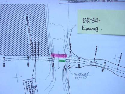
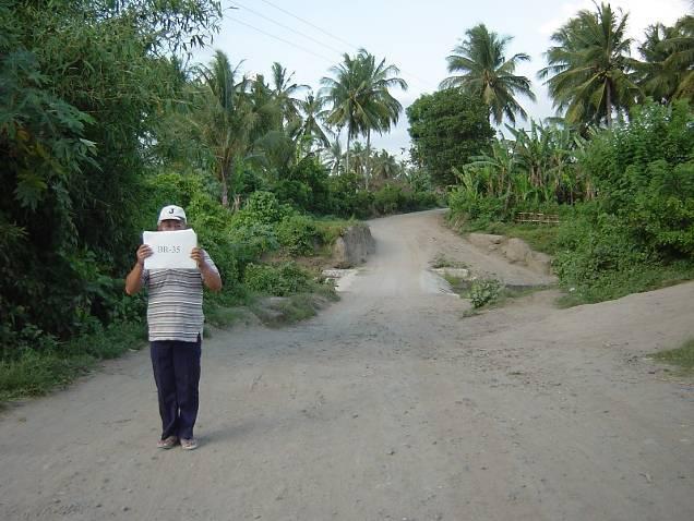
13 Photo-1 Location of Permanent Land Acquisition at BR34 Figure-5 Topographical Map at BR34 Photo-2 Location of Temporary Land Acquisition at BR35