Clonaslee Borehole - Forest
|
|
|
- Lee Gaines
- 5 years ago
- Views:
Transcription

 BH.")

1 Water Framework Directive Groundwater Monitoring Programme Site Information Clonaslee Borehole - Forest ImagePath1: Clonaslee Borehole - Forest\IE_SH_G_19_002_a_Pum phouse.jpg Clonaslee (Forest) borehole is one of two boreholes, the other being the Clonaslee (Plant) BH. The abstraction from Clonaslee Forest borehole is 200 m³/day, while the abstraction from Clonaslee Plant borehole is 130 m³/day; the ZOC has been delineated for the abstraction from the two boreholes. A source report has been completed by WYG. August 2011 Offaly
2 Site Name: RBD: Site Use: Clonaslee Borehole - Forest Shannon IRBD Easting: Northing: Drinking Water (PWS) Hydrometric Area: 25 Townland: Ownership: Water Quality Monitoring Network: BRITTAS Offaly County Council SITE INFORMATION County: EU Reporting Code: GWB Name: GWB Code: Drinking Water Code: Water Level Monitoring Network: Level Offaly IE_SH_G_066_19_002 Clonaslee West IE_SH_G_ PUB1020 Surveillance Operational (Point) Operational (Diffuse) Y N N N Flow N Site Comments: Clonaslee (Forest) borehole is situated in a Regionally Important Fissured Aquifer (Rf) / Devonian Kiltorcan-type Sandstone. The Clonaslee Forest BH is included in the GW surveillance monitoring network. Location and Access Information: SITE DIRECTIONS From Dublin, take M7 for Cork and turn off for Mountmellick just before Portlaoise. Drive through Mountmellick for Clonaslee village along the R422. Drive along the main street and take a left up a narrow road, next to a shop (Peavoy) and drive until arrive at Water Treatment Works. Additional Comments: Monitoring Point Type: Borehole Log Available: Top of Casing (m agl): BH WELL INFORMATION Abstraction Rate (m³/d): 200 Ground Elevation (m OD): 110 Total Drilled Depth (m bgl): 50 Depth to Bedrock (m bgl): 7 Upper Casing Diameter (mm): 150 Lower Casing Diameter (mm): Final Borehole Depth (m): Upper Casing Bottom Depth (m bgl) : 8 Lower Casing Bottom Depth (m bgl): Screen Interval (m bgl): Grout Type (cement,bentonite): Gravel Pack Interval (m bgl): Potential Yield (m³/day): 600 Specific Capacity (m³/d/m): 23 Screen Type (PVC,Steel,other): Comments on Monitoring Site: Screen Slot Size (mm): Grouted above (m bgl): Grout Volume Injected (m³): Gravel Pack Volume (m³): Open Hole Interval (m bgl): The sampling notes indicate the sample is taken from the borehole. The groundwater supplied from the Clonsalee boreholes is mixed with surface water prior to distribution. Water entries at 9, 30, 45, 51m - main inflow at 9m. Static Water Level (m bgl): artesian Scheme Name: Source Report Info: Clonaslee Report completed by WYG Number of Abstraction Points in the Scheme: 2 Source Report Available Y Scheme Summary: Clonaslee Borehole - Forest is part of a larger water supply, including Clonaslee Plant which also has a site folder. Page 2 of 5
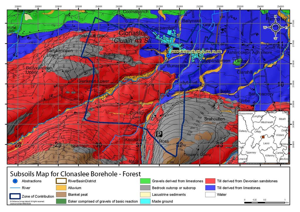
3 HYDROGEOLOGY GEOLOGY Soil: Subsoil: Bedrock: Alluviums (AlluvMIN) Alluvium (A) Devonian Kiltorcan-type Sandstones Subsoil Permeability: Moderate HYDROGEOLOGY ZONE OF CONTRIBUTION Aquifer Category: Estimated ZOC Size (km²): ZOC Delineation Comments: Vulnerability Rf at Monitoring Moderate Flow Regime: Productive site: fissured bedrock 6.7 ZOC Delineated By: Tobin (CK) Recharge Est Recharge (mm/yr): Estimate (mm/yr): Original ZOC delineated for entire well field. The ZOC for Clonaslee (Forest and Plant) is based on the original WYG ZOC, though smaller based on lower abstraction rates and topography. The ZOC is larger than the cumulative abstraction of Forest and Plant (150%). 344 Groundwater Vulnerability within ZOC (% area): Extreme (X) Extreme (E) High Moderate Low 0 High to Low 0 Unclassified 0 Hydrochemical Signature: Alkalinity (mg/l HCO3): Hardness (mg/l CaCO3): Conductivity (us/cm): Monitoring Record Period: Pressure (e.g., Nitrates, Phosphates, Abstractions): Average: 278 Average: 324 Average: 558 From: 1995 Ca-HCO3 Diffuse Range: Range: Range: To: 2010 HYDROCHEMISTRY Additional Water Chemistry Information: RISK ASSESSMENT Typical Contaminants: During the monitoring period: The average nitrate concentration was 11 mg/l NO3 and the maximum nitrate concentration was 13 mg/l NO3. The average ammonium concentration was mg/l N and the maximum ammonium concentration was 0.19 mg/l N. The average molybdate reductive phosphorus (MRP) concentration was mg/l P and the maximum MRP concentration was mg/l P. The average chloride concentration was 14.5 mg/l Cl and the maximum chloride concentration was 20.6 mg/l Cl. Nitrates Risk Category: At risk, low confidence GWB Status: Good Impact Potential within ZOC (% area): Extreme: 0.00 High: Moderate: Low: Negligible: OTHER INFORMATION Page 3 of 5
4 Pump House Page 4 of 5
5 Data Summary Sheet - July 2011 Disclaimer: The data in this document are based on the best available information and understanding at time of writing. Neither the Environmental Protection Agency, nor the individual bodies supplying data for this document and accompanying maps will be responsible for any loss or damage from the use or interpretation of these data. Rock Unit Geology Map: GSI, 2009 Aquifer Type Map: GSI, 2009 Groundwater Vulnerability Map: GSI, 2009 Soils & Subsoils Type: Teagasc, 2007 Recharge Map: GSI, 2009 Impact Potential Map: EPA, 2009 Risk Assessment Map: EPA WFD Risk Assessment, 2006 Groundwater Body Status: EPA WFD Status Assessment, 2008 Water Quality Data: EPA WFD Monitoring, 2008 Groundwater Threshold Values Groundwater threshold values for selected parameters: Nitrate - General Chemical Test/ Drinking Water Test (37.5 mg/i N03) Ammonium - Drinking Water Test (0.175 mg/i N) / Surface Water Test (0.065 mg/l N) Molybdate Reactive Phosphorus (MRP) - Surface Water Test (0.035 mg/i P) Chloride -Saline/Intrusive Test (24 mg/i) / Drinking Water Test (175 mg/i Cl) Electrical Conductivity -Saline/Intrusive Test (800 µs/cm) / Drinking Water Test (1,875 µs/cm) Further information on groundwater threshold values is contained in the Groundwater Regulations (S.I. No.9 of 2010). General Downgradient Distances General Downgradient Distances (XL) applied to boreholes sourced in bedrock aquifers are constrained to estimate approximate limits based on data at the GSl. ln some cases they may be higher or lower depending on local conditions. Rk, Rkd, Lk Lm Ll, PI 225 m 150 m 60 m It is assumed that groundwater downgradient of a spring cannot flow back up to the spring, however a precautionary 30m buffer is generally applied which allows for instances where pumping under dry weather periods may induce a drawdown or where the ground may be sloping toward the spring from the downgradient side. Version 0: Version 1: Version 2: Version 3: Version 4: Prepared by Date: Prepared by Tobin (CK) Date: Mar 2011 Prepared by Date: Prepared by Date: Prepared by Date: Page 5 of 5

6
7
8

9
10
11 ² 2500PUB1020 / IE_SH_G_066_19_ !. Cavan Roscommon Louth Longford Meath Westmeath Dublin Offaly Kildare ) Laois Wicklow Clare Tipperary Carlow Kilkenny Wexford Limerick Soils Map for Clonaslee Borehole - Forest!. Abstractions RiverBasinDistrict Acid Shallow Well Drained Mineral Basic Deep Well Drained Mineral Basic Shallow Poorly Drained Mineral Made River Acid Deep Well Drained Mineral Acid Shallow Poorly Drained Mineral Basic Deep Poorly Drained Mineral Blanket Peat Water Acid Deep Poorly Drained Mineral Acid Shallow Poorly Drained Peaty Mineral Basic Poorly Drained Peaty Mineral Mineral Alluvium Acid Poorly Drained Peaty Mineral Acid Shallow/Rocky/Peaty Mineral Basic Shallow Well Drained Mineral Lacustrine Zone of Contribution Ordnance Survey Ireland. All rights reserved. Licence number EN km Galway