BIG CYPRESS NATIONAL PRESERVE and PROPOSED OIL DEVELOPMENT. Alison Kelly Staff Attorney
|
|
|
- Amanda Cook
- 5 years ago
- Views:
Transcription
1 BIG CYPRESS NATIONAL PRESERVE and PROPOSED OIL DEVELOPMENT Alison Kelly Staff Attorney October 28, 2015
2 Big Cypress National Preserve he Big Cypress was established by Congress in 1974 [i]n order to assure the preservation, conservation, and protection of the natural, scenic, hydrologic, floral and faunal, and recreational values of the Big Cypress Watershed and to provide for the enhancement and public enjoyment thereof. The Big Cypress was established by Congress in 1974 and expanded in 1988: [i]n order to assure the preservation, conservation, and protection of the natural, scenic, hydrologic, floral and faunal, and recreational values of the Big Cypress Watershed and to provide for the enhancement and public enjoyment thereof.

3
4 Preserve Values at Stake Important Resource Areas: Cypress strands, mixed-hardwood swamps, sloughs, cypress domes, marshes, hardwood hammocks, old-growth pinelands, and mangrove forests. Vital wildlife habitat for the endangered Florida panther and other terrestrial and aquatic species. Clean water for Big Cypress Basin and Everglades National Park. Treasured outdoor recreation opportunities.
5 Sunniland Oil Trend Hydrocarbon-bearing South Florida Geologic Basin located beneath southwest Florida. Oil production within the Preserve includes multiple wells in two areas (Bear Island & Raccoon Point).

6
7 Split Estate Exists when the surface of the land and the minerals (oil) beneath it are owned by different entities. Collier family entities conveyed most of the Addition Lands to the NPS reserved oil and gas rights. Federal government = a surface estate owner Collier entities = mineral (oil) estate owners
8 Oil exploration: Seismic Survey December, 2014 Burnett Oil Company submitted a revised Plan of Operation (POP) to the Nat l Park Service for Phase I. Encompasses ±110 square miles (70,000 acres) of the Preserve. 75% of the seismic surveying will occur in the Preserve, and 25% will occur in the Addition. Subsequent phases will be submitted in separate POPs at later dates. The company has proposed 4 phases over 4 years encompassing ±360 square miles (230,000 acres) of the Preserve.

9
10
11 Seismic Survey Methodology Portable seismic receivers (geophones) and recording devices measure and record subtle vibrations in the ground. Vibrations will be created using mobile plates attached to heavy 67,100-pound ( vibroseis ) trucks. The vibration devices and geophones will receive return seismic signals from the subsurface geology. Used to map commercial quantities of crude oil and natural gas in the Sunniland Oil Trend beneath the survey area. 18-week work period in the dry season.

12
13 Seismic Survey Methodology Vibrating points and seismic recording devices will be placed along source receiver lines. Construction of 5 separate staging areas 4 in wetlands. Construction of a composite interlocking mat system in wetlands to accommodate the passage of vibroseis trucks and other off-road vehicles.

14

15
16

17


18
19 Environmental Impacts of Oil Exploration Adverse impacts on wildlife and habitats. Defoliation and flattening of vegetation. Changes to vegetative species composition. Compaction, rutting, and other damage to soils. Permanent changes to local hydrology. Air emissions. Other risks.
20 Florida Panther Impacts The Florida panther is one of the most endangered mammals in the country. Exploration will overlap with denning. Alterations to the normal behavior due to noise from equipment and disruption in prey and use of habitat. Potential for increase in road kills.

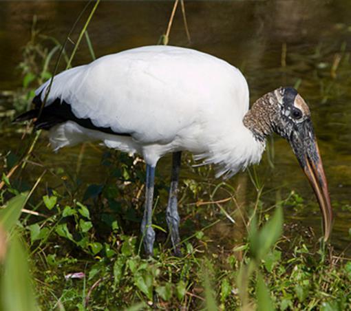
21

22
23 Other Mammal Impacts The Preserve is home to the Florida black bear, bobcat, and the manatee, among other mammals. Potential for collapse of burrows utilized by the Gopher tortoise and threatened Eastern Indigo snake due to the weight and vibrations of vibroseis trucks. Survey area is within the established endangered Florida Bonneted bat focal area.

24

25

26


27
28 Bird Impacts The Preserve is home to nearly 200 species of birds, including the endangered Red-Cockaded woodpecker and the threatened Wood stork. The threatened Audubon s Crested caracara and the endangered Everglade Snail kite may also be present. Operations may interfere with foraging and nesting.


29
30 Water Resource Impacts Vibroseis trucks could crack or fracture shallow limestone formations beneath the Preserve. Damaged limestone = significant change to hydrology: Sinkhole formation. Drainage of perched hydrologic environments. Far reaching adverse environmental impacts: Preserve hydrology maintains hydroperiod regimes for wetlands; Serves as an important potable water source for the Big Cypress Basin; and Provides clean water to the Everglades.
31 Other Environmental Impacts Introduction of invasive plant species. Creation of unauthorized off-road vehicle routes. Increase in air emissions in the survey area. Risks to the Big Cypress and Everglades watersheds from oil and gas spills, erosion, and sedimentation. Impacts to lands with wilderness characteristics, potentially impairing the opportunities for future wilderness designation.

32

33

34
35 Recreational & Cultural Impacts Conflicts with recreational activities and sites, including camping, hiking, and wildlife viewing. Visual and noise impacts during the proposed operations. Long-term degradation of the natural and scenic qualities of the Preserve. Impacts to tourism industry. Damage to cultural resources.
36 POP Deficiencies Fails to avoid important habitat, Important Resource Areas, and recreation areas. Fails to provide adequate buffers necessary to maintain specified distances from sensitive ecosystems and habitats. Fails to fully evaluate impacts to karsted limestone and surficial aquifers, and implications for water resources. Lacks detailed plans for reclamation.
37 Seismic Surveying by Tocala, LLC Proposed directly to the north of the Preserve. 161 square miles (103,000 acres) on private and public land, including a portion of Dinner Island Ranch Wildlife Management Area. Drilling 8,800 shot holes - seismic explosives placed at depths between feet below the surface in each hole. The seismic surveying activities by Tocala, LLC and Burnett Oil Company will result in cumulative, large scale impacts to wildlife and other natural resources in the Preserve.

38


39 What happens if oil resources are found?
40 Air Quality Impacts from Production Hazardous Air Pollutants (HAPs) Benzene, formaldehyde, xylenes from natural, chemical or combustion sources. Can be vented or flared. Wastewater can be routed into open air pits and left to evaporate. Ozone Caused by VOCs, NOx and sunlight Particulates Dust, soot, chemicals from fuel combustion
41 Health Impacts from Air Pollution Scientific studies repeatedly find air pollution levels high enough to cause short-term symptoms like shortness of breath or dizziness and long-term effects like birth defects, blood disorders, and cancer. The health threats from air pollution are not limited to communities with drilling directly in their backyards; regions with high levels of oil and gas activity are paying the price with smoggy skies and respiratory problems.
42 Groundwater Contamination Drilling and fracking can cause contamination of groundwater: Naturally occurring substances or chemical additives. Benzene and other contaminants have been found in water wells in Wyoming, Colorado, Pennsylvania, Arkansas, Alabama, Ohio, and Texas.
43 Legal Requirements NPS Organic Act (16 U.S.C. 1 et seq.) NPS rules in 36 C.F.R. Part 9, Subpart B ( 9B Rules ) The Big Cypress National Preserve General Management Plan (GMP) and Minerals Management Plan (MMP) (1992) Agreement among the United States of America, Collier Enterprises, and Barron Collier Company (1988) ( Addition Lands Agreement ) National Environmental Policy Act (NEPA) Endangered Species Act (ESA) Clean Water Act (CWA) National Historic Preservation Act (NHPA) State laws Florida Water Resources Act Chapter 373, Florida Statutes. FDEP Oil and Gas Permit Chapter 377, Florida Statutes.
44 NPS Statutory Authority Broad authority to limit oil and gas exploration that conflicts with other resources in the Preserve. Organic Act provides the authority to regulate non-federal oil and gas activities to protect Preserve resources and values. Addition Act requires rules governing oil & gas exploration and development that are consistent with the purposes for which the Preserve and the Addition were established.
45 NPS 9B Rules Regulate conduct associated with private mineral rights on public lands to avoid or minimize harm to resources and values. Operations must be conducted in a manner which utilizes technologically feasible methods least damaging to the federally owned or controlled lands, waters, and resources. Must assure the protection of public health and safety in all cases. There must be a plan for reclamation and a performance bond. Rules have not been substantively amended in over 35 years. NPS undergoing rulemaking to update these rules.
46 Next Steps NPS must release a NEPA document. NPS must conduct an Environmental Impact Statement (EIS) under NEPA to evaluate the cumulative impacts and climate change effects on any oil development that considers: Future phases of exploration and production. Adjacent seismic surveying by Tocala, LLC. Public comments. The U.S. Army Corps of Engineers should issue an individual Section 404 permit under the CWA. Additional approvals will be required if drilling is proposed.
47 What can you do? Monitor the progress of the NPS decision on the POP. PEPC Planning, Environment & Public Comment website: Sign up for NRDC Action Alerts at Monitor the progress of the Corps decision on a Section 404 CWA permit. Jacksonville District, Ft. Myers Regulatory Section Participate in the NEPA process. Attend public meetings. Submit comments.


48 THANK YOU!