Environmental Geochemistry II. Aleš Bajer
|
|
|
- Aron Barnett
- 5 years ago
- Views:
Transcription


1 Environmental Geochemistry II. Aleš Bajer Tento projekt je spolufinancován Evropským sociálním fondem a Státním rozpočtem ČR InoBio CZ.1.07/2.2.00/
2 Environmental Geochemistry Water and hydrosphere The hydrologic cycle Fresh water Ground water Glaciers and Ice Ages Desert and desertification Human impact on water
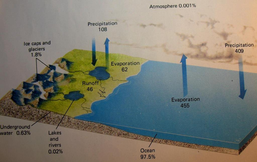
3 Hydrologic cycle How inappropriate to call this planet Earth, when clearly it is Ocean Arthur C. Clarke - 1,3 billion cubic kilometers water on /or near the surface - 97,5% is salty sea water - 1,8% is frozen water (ice caps of Antarctica and Greenland) - 0,65% is fresh water (stream, lakes, wetlands) including underground water - continuous movement of water between the earth and the atmosphere - Energy resource is the Sun - main processes: evaporation and transpiration condensation and precipitation runoff and groundwater
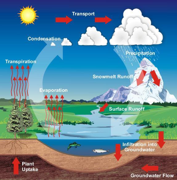
4 Hydrologic cycle
 of")
5 Hydrologic cycle reservoirs (supply) of water
6 Hydrologic cycle Evaporation -Substance (water) changes from the liquid phase to the gas phase Transpiration - The evaporation of water through plant membranes. These are two imporant way in which water vapor enters the atmosphere
7 Hydrologic cycle Condensation -Substance (water) changes from the gas to the liquid phase - can be observed as clouds, fog, dew, or frost form Precipitation - cloud are composed of many droplets - when droplets are not be able to stay in the cloud, they fall out of the cloud as precipitation - precipitation can be liquid or solid (rain, snow)
8 Hydrologic cycle Runoff and Groundwater -both driven by precipitation Runoff: ground cannot absorb any more water flow into streams All groundwater as stream, river, lakes, dam are called surface water Underground water: absorbed precipitation into the ground, makes underground reservoir (aquifer)
9 Hydrologic cycle

10 Hydrologic cycle underground water table

11 Hydrologic cycle spring forms A the contact between permeable and impermeable rock layer B - water trap above impermeable shale, lies above the main water table C - water flows from fraction in permeable bedrocks D - springs from carstic surface

12 Hydrologic cycle an artesian aquifer - water is under presure in aguifer - water flows from artesian well spontaneously

13 Hydrologic cycle Human impact - Wetland losses in USA in the past 200 years - in past 200 years Europe and USA was drying cca 50% of Wetlands

14 Abundance of wetlands in the United States
 Total water consumption per person (combination of all")
15 Water requirements (consumption) - 3 categories of water consumption: domestic household water consumption (800 l/person in USA, 200 l/person in CZ) industry much more than domestic 2 parts: cooling system of electric power plant = 2/3 production of industrial product = 1/3 agriculture - irrigation (USA 41%, CZ 6% of total water consumption) Total water consumption per person (combination of all categories): USA = l/person/day Western Europe = l/person/day CZ = l/person/day Sudan = 90 l/person/day
 in USA millions of")
16 Average annual precipitation in USA Average annual water use (total) in USA millions of liters/day/country


17 Amount of water used to produce selected industrial products in USA Amount of water used to produce selected agriculture products in USA
 water - provides drinking water for 40% of world population - main resource of water for industry")
18 - A pump draws water from the well faster than it can flow into the well through the acquifer, and a cone of depression forms. Water and hydrosphere Ground (underground) water - provides drinking water for 40% of world population - main resource of water for industry and irrigation

19 Ground (underground) water coastal area - fresh water lies above salt water - If too much water is removed the water table declines. -The level of salt water rises and contaminates the well.
20 Water pollution - categories of pollutants: sewage wastewater from household activities variable (toilets, organic matter, soaps, detergents, etc.) plant nutrients phosphates and nitrates cause eutrophication industrial organic compounds 2 kinds: biodegradable (natural materials) nonbiodegradable (dioxin, DDT), often toxic toxic inorganic compounds from industry (mine wastes, road salt, industrial metals etc. radioactive materials wastes from mining, nuclear power plants, nuclear weapons, medical and scientific application
21 Water pollution control strategies - dispersal: Dilution is the solution to pollution. reducing of concentration of pollutant -destruction: by strong acids, bases, oxidizing agents, high temperatures the result is simple compound such as water, carbon dioxide other oxides is not possible to use in case of radioactive substances -isolation: -recycling: of waste and store them must be protected from weathering, accidents, catastrophic events (earthquakes, volcanoes, war) reuse of waste converting to a useful material

22 Recycling Water and hydrosphere Recycling is excellent solution, but can be use only for some materials.

23 Pollution Water and hydrosphere

24 Glaciers and Ice Ages - snow that does not melt, is gradually changing into firn and finally into ice. During this process the density is growing. - When density is higher than 0.85 g/cm3, firn has changed into ice. - If accumalation of ice and snow is massive and long-lasting glacier is formed. - Glacier form in two environment: high snowy mountains polar regions Alpine glacier slope, valley in high mountains Continental glacier - ice sheet in polar region (Antarctica, Greenland)

25 Features of Alpine glaciers

26 Erosional Landforms created by alpine glaciers
27 Glacial deposits - all sizes mixture, unstratified, unsorted, glacial ice deposits are called TILL - Till deposited by the glaciar is called MORAINE - Long, snakelike ridge formed by channel deposit of stream beneath a glacier is called ESKER - Small hills of sand and gravel deposited by streams during glacier melting called KAMES

28 Erosional Landforms created by continental glaciers
29 The Ice Ages Water and hydrosphere - A time when alpine glaciers descend into lowland valleys and continental glaciers spread over higher latitudes is called an ICE AGE or a GLACIAL EPOCH - Geological evidence shows that at least 5 major Ice Ages have occured during last 1 billion years.

30 The Ice Ages Water and hydrosphere
 - whole England was covered with ice - North and Baltic sea were under")
31 Pleistocene continental glaciers ( BP) - whole England was covered with ice - North and Baltic sea were under ice-cover - small alpine glaciers were in Giant Mountains
 -")

32 Pyrenees (Spain) - firn glacier
33 Desert and desertification - area with annual precipitation of less than 200 mm - useually surrounded by semiarid regions - the world s largest deserts occur near 30 o north and south latitudes - also in the rain shadows of mountains, in continental interiors - wind is an important agent of erosion, transport and deposition -2 types of deserts: a) most common type consists of largely barren, hard, rocky plateaus,without sand = REG b)area covered with wind-blown sand, covers about 20% Earth s deserts = ERG

34 Desert and desertification - Most important desert s areas in the world

35 Desert and desertification - Formation of desert pavement - places where sand is removed = ERG - places where is no sand = REG

36 Desert and desertification REG ERG
 Cairo (Egypt) Las Vegas (USA) Baghdad")
37 Desert and desertification - 20% of continents has a risk of being desertificated - 20% of world population live in this risk area - it is very expensive to protect these areas from desertifidation - examples: Beiing (China) Cairo (Egypt) Las Vegas (USA) Baghdad (Iraq)