Components, sub-components and statistical topics of the FDES 2013
|
|
|
- Belinda May
- 5 years ago
- Views:
Transcription
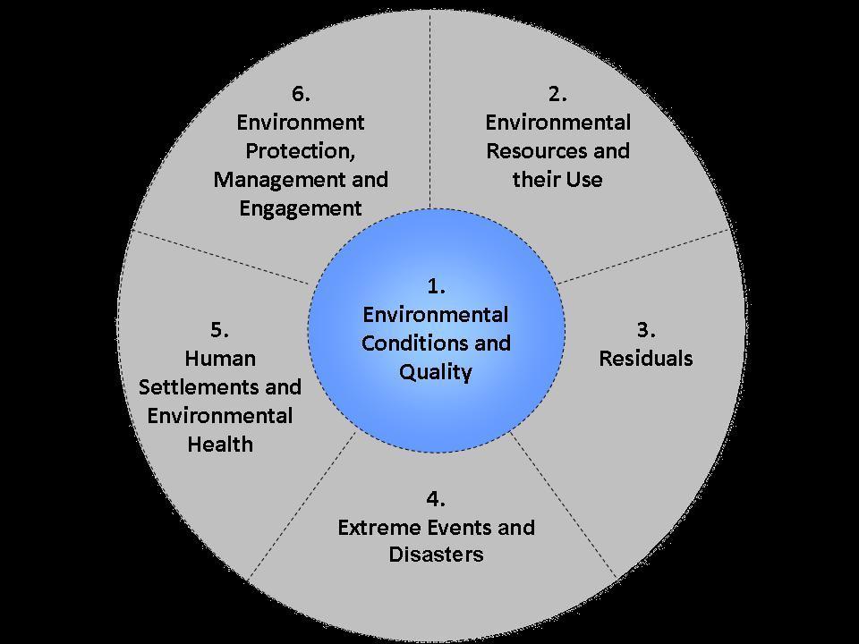
1 Environment Statistics Section, United Nations Statistics Division Components, sub-components and statistical topics of the FDES 2013 Component 1: Environmental conditions and quality 6. Environment Protection, Management and Engagement 2. Environmental Resources and their Use 5. Human Settlements and Environmental Health 1. Environmental Conditions and Quality 4. Extreme Events and Disasters 3. Residuals Workshop on Environment Statistics in support of the implementation of the Framework for the Development of Environment Statistics (FDES 2013) (Calodyne, Mauritius, January 2015)
2 6. Environment Protection, Management and Engagement 2. Environmental Resources and their Use 5. Human Settlements and Environmental Health 1. Environmental Conditions and Quality 4. Extreme Events and Disasters 3. Residuals This presentation has been elaborated by the Environment Statistics Section of the United Nations Statistics Division. Based on Chapter 3 of the Framework for the Development of Environment Statistics (FDES) 2013 that can be downloaded here: Environment.pdf

3 Component 1: Environmental Conditions and Quality


4 Contents of Component 1: Environmental Conditions and Quality Component 1 is is at at the the centre centre of of the the FDES FDES structure. structure. Other Other components components of the FDES are of structured the FDES in are their structured relationship according to it. to their relationship to it. It encompasses conditions and quality of environment and their change. It describes conditions and quality of the environment and their It includes statistics about the physical, biological and chemical change. characteristics of the environment over time. It includes statistics about the physical, biological and chemical These characteristics are strongly interrelated and determine the characteristics of the environment and their changes over time. types, extent, conditions and health of ecosystems. These characteristics are strongly interrelated and determine the types, extent, conditions and health of ecosystems.
5 Component 1: Environmental Conditions and Quality Scope and Content Meteorological, hydrographical, geological, geographical, biological, physical and chemical conditions. Characteristics of the environment that determine ecosystems and environmental quality. Relationship with other frameworks: Relevant to the State and Impact elements of the Driving force- Pressure- State- Impact- Response (DPSIR) framework. Relates to the Experimental Ecosystem Accounts of the SEEA. Exclusions: Stocks and flows of environmental resources are discussed in Component 2.
6 Contents of Component 1: Environmental Conditions and Quality Types of data and information used Geospatial Physical Qualitative description Main sources Monitoring Remote sensing Cartographic data Inventories, registers, cadasters Institutional partners Environmental, meteorological, hydrological, geological and geographical authorities or institutions.
7 Component 1: Overview Component 1 Environmental Conditions and Quality Sub-Component 1.1 Physical Conditions (four topics, 63 statistics) Sub-Component 1.2 Land Cover, Ecosystems and Biodiversity (four topics, 30 statistics) Sub-Component 1.3 Environmental Quality (five topics, 61 statistics) Topic 1.1.1: Atmosphere, climate and weather Topic 1.1.2: Hydrographical characteristics Topic 1.1.3: Geological and geographical information Topic 1.1.4: Soil characteristics Topic 1.2.1: Land cover Topic 1.2.2: Ecosystems Topic 1.2.3: Biodiversity Topic 1.2.4: Forests Topic 1.3.1: Air quality Topic 1.3.2: Freshwater quality Topic 1.3.3: Marine water quality Topic 1.3.4: Soil pollution Topic 1.3.5: Noise

8 Sub-Component 1.1: Physical Conditions Topic Atmosphere, climate and weather Sub-Component 1.1 Physical Conditions Topic Hydrographical characteristics Topic Geological and geographical characteristics Topic Soil characteristics


9 Sub-Component 1.1: Physical Conditions Captures those physical aspects of the environment which change slowly due to human influence. Contains statistics, geospatial information and descriptions on meteorological, hydrographical, geological, and geographical conditions.
.")
10 Sub-Component 1.1: Physical Conditions Topic 1.1.1: Atmosphere, climate and weather Covers data on atmospheric, climatic and weather conditions across territories and over time. Information on weather describes atmospheric behaviour over a given territory in the short term (recorded through a network of monitoring stations). Climate is determined by long-term weather conditions. Weather data usually include among others: temperature, precipitation, humidity, pressure, wind speed, solar radiation, ultraviolet (UV) radiation, and (where relevant) occurrence of El Niño and La Niña events. Atmospheric, weather/climate authorities monitor/record these data over long periods of time using a network of monitoring stations. Statistics on air quality are covered under Topic Air quality.

11 Sub-Component 1.1: Physical Conditions Topic 1.1.2: Hydrographical characteristics Includes information on the extent, location and characteristics of lakes, rivers, reservoirs, watersheds, seas, groundwater bodies and glaciers. Best presented in the form of maps. Primary sources are hydrographical and hydrological information systems managed by national geographical, hydrological institutions and water authorities. Statistics on water quality are covered in Topic Statistics on freshwater resources and their use are covered under Sub-component 2.6 Water Resources.
 and topographic information, presenting statistics that inform on the extent and characteristics of the country s territory and relief.")
12 Sub-Component 1.1: Physical Conditions Topic 1.1.3: Geological and geographical information Includes general geological (e.g. bedrock, fault lines, volcanoes) and topographic information, presenting statistics that inform on the extent and characteristics of the country s territory and relief. Data are often presented in the form of maps. Main data sources are information systems run by national geographical and geological institutions / authorities. Statistics on geological resources are covered under Component 2.

13 Sub-Component 1.1: Physical Conditions Topic 1.1.4: Soil characteristics Soil provides the physical base to support production and cycling of biological resources, it is source of nutrients and water for agriculture and forestry systems, and it plays an important role in carbon sequestration. The topic covers information on soil types, soil quality (e.g. nutrient content) and the extent of soil degradation. Degradation includes erosion, salinization and compacting; nutrient content measures levels of Nitrogen, Phosphorous, Calcium, etc. Soil types can be defined using information on the combinations of soil components and properties. Statistics on soil pollution are covered under Topic

14 Sub-Component 1.2: Land Cover, Ecosystems and Biodiversity Topic Land Cover Sub-Component 1.2 Land Cover, Ecosystems and Biodiversity Topic Ecosystems Topic Biodiversity Topic Forests
15 Sub-Component 1.2: Landcover, Ecosystems and Biodiversity Organizes environment statistics on land cover, ecosystems and biodiversity, as well as their recordable changes over time and across locations. Because of the importance of forests worldwide, most important statistics required to describe them are organized under a separate topic. Exclusions Statistics on biological resources (timber, fish, etc.) and their harvesting are contained in Component 2: Environmental Resources and their Use.
 is used.")
16 Sub-Component 1.2: Land Cover, Ecosystems & Biodiversity Topic 1.2.1: Land Cover Land cover is the observed biophysical cover on the earth s surface. SEEA LC classification based on FAO s Land Cover Classification System (LCCS) is used. It comprises 14 classes and provides a common framework to compile and aggregate land cover information available at the national level and make it comparable at the international level. Includes statistics on the extent and location of the different land cover categories (physical and spatial characteristics of land cover). Main source of land cover information is remote sensing data, usually satellite images or aerial photographs and field surveys which are combined to map the different categories of land cover. These sources are interpreted and transformed into geospatial data and statistics.
17 Sub-Component 1.2: Land Cover, Ecosystems & Biodiversity Topic 1.2.2: Ecosystems Ecosystems are dynamic complexes of plant, animal and microorganism communities and the non-living environment interacting as functional units. The extent and conditions of ecosystems determine their capacity to produce ecosystem services. The topic includes physical, descriptive and qualitative information and statistics about a country s main ecosystems and their conditions. The Millennium Ecosystem Assessment provides an ecosystem classification (i.e. forest, mountain, cultivated, dryland, polar, inland water, marine, coastal, island, urban, etc.). National classifications can also be used and described for statistical purposes.
18 Sub-Component 1.2: Land Cover, Ecosystems & Biodiversity Topic 1.2.3: Biodiversity Contains statistics on the diversity of flora and fauna species (biota), as well as on protected areas and protected flora and fauna species. Flora & fauna: descriptive information on their existence, variety and trends in various populations and communities. Also quantitative and complementary information on biodiversity in terrestrial and marine environments. Statistics on the status of vulnerability of species as well as on protected species are also included. Protected areas: physical and descriptive information and statistics on protected terrestrial and marine areas within the country. The IUCN Protected Area Management Categories are based on the strictness of protection and serve as the classification for protected areas. Main sources of data on protected areas are administrative records. Environmental authorities reports on the state of ecosystems or the state of the environment at the national and sub-national levels also provide data. Protected species data are often acquired on an adhoc basis from studies, assessments, NGO research, etc. Data can therefore be scattered and non-systemised.
.")
19 Sub-Component 1.2: Land Cover, Ecosystems & Biodiversity Topic 1.2.4: Forests Forests are a land cover/ecosystem category that due to its significance is discussed under a separate topic in the FDES. Relevant statistics include forest area by different categories (tree species, age, health etc.). Further statistics are forest biomass and its carbon storage, and a characterization of forest ecosystems. Forest area can also be disaggregated by the level of human management (e.g. natural forest, planted forest, etc.). Sources include data obtained via remote sensing, forest inventories and forestry statistics from forest management agencies (e.g., agricultural and forestry authorities). Timber and other forest resources and their use are covered under Component 2.
20 Sub-Component 1.3: Environmental Quality Topic Air Quality Sub-Component 1.3 Environmental Quality Topic Freshwater Quality Topic Marine Water Quality Topic Soil Pollution Topic Noise
21 Sub-Component 1.3: Environmental Quality Organizes statistics on the concentration of pollutants in ambient air, freshwater, marine water, soil, as well as on noise levels. Statistics on environment quality are required by policy makers, analysts and civil society to monitor and make evidence-based policies to maintain and improve environmental quality. Pollution impacts both the human sub-system and ecosystems. Because of spatial and temporal considerations, and the fluidity of pollution through environmental media, collaboration between statistical offices and environmental agencies regarding design (sampling pattern) is important. Exclusions Emissions (discharge) of pollutants from human activities are covered in Component 3.
22 Sub-Component 1.3: Environmental Quality Topic 1.3.1: Air Quality Includes statistics on the ambient concentration of the most important substances that can have a negative effect on human and ecosystem health and climate change. While national monitoring of air quality usually focuses on urban settlements where polluting activities affect a concentrated population, it is also frequently implemented in targeted ecosystems or habitats of high vulnerability. Statistics based on these measurements can be used to describe certain aspects of ecosystem health in specific locations. Sources are monitoring stations (impact, regional or background).

23 Sub-Component 1.3: Environmental Quality Topic 1.3.2: Freshwater Quality Described by concentrations of substances such as nutrients and chlorophyll, organic matter, pathogens, metals, and organic contaminants, as well as by physical and chemical characteristics in surface water and groundwater. Without good quality freshwater, ecosystems and humans cannot survive. Precipitation, aquifers, groundwater, lakes, rivers, coastal zones and oceans are all interconnected. Therefore, the choice of where to measure or monitor the pollutants and which pollutants to monitor will depend on local and national priorities, ecosystem characteristics and resources available. Data for water quality statistics are primarily produced by monitoring stations.


24 Sub-Component 1.3: Environmental Quality Topic 1.3.3: Marine Water Quality Relevant statistics can include nutrients and chlorophyll, organic matter, pathogens, metals, organic contaminants, and physical and chemical characteristics, as well as coral bleaching. Can be locally, nationally or supra-nationally relevant, in terms of the type of pollution and effect. Sources are typically national or international monitoring stations associated with scientific research. Important to the health of ecosystems as well as to humans.
25 Sub-Component 1.3: Environmental Quality Topic 1.3.4: Soil Pollution Soil pollution is caused by chemicals and other residuals disposed of by humans. Relevant statistics include the number and area of contaminated, potentially contaminated, remediated and other sites. Most commonly measured soil pollutants include petroleum hydrocarbons (e.g., oil residuals and solvents), pesticides and heavy metals. Soil pollution directly affects human and environmental health, and the productivity of land, depending on the pollutant concentration, depth of contact with biota and density of humans in polluted areas. Sources are primarily produced by field measurements at specific locations. Such data requires further processing to produce environment statistics. Data available for statistical purposes are usually limited and not systematic.

26 Sub-Component 1.3: Environmental Quality Topic 1.3.5: Noise Noise pollution exists in cities, adjacent to highways, near airports and marine ports and around manufacturing, metal processing and mining establishments and at construction sites. Statistics on noise levels and intensity, are produced for and are relevant to the specific local areas where the most problematic conditions of noise pollution exist. Noise pollution is typically measured using calibrated instruments in specific spatially located stations. Monitoring stations are typically run by pertinent national or local environment authority. Noise pollution negatively affects the welfare and health of humans and also affects and changes ecosystems.


27 Questions, comments for Component 1?