Contents. Sancrox Quarry Expansion Preliminary Environmental Assessment 2015
|
|
|
- Meredith Harrell
- 5 years ago
- Views:
Transcription

1
2 Contents 1 Introduction Site Description The Proponent Purpose of the Document Land Ownership Crown Land Purchase Site Current Development Consent and Operations Operational Development Application Hours of Operations and Employment Proposed Project Land Closure and Purchase Site Ancillary Infrastructure Stakeholder Consultation Planning Considerations State Planning Issues Key Issues Ecology Visual Impacts Noise and Blasting Impacts Air Quality Traffic Surface and Ground Water Waste Aboriginal Archaeology Socio-Economic Impacts Conclusion
3 List of Figures and Tables List of Figures Figure 1: Site location... 7 Figure 2: Property Ownership and Site Boundary... 9 Figure 3: Current Infrastructure Area...13 Figure 4: Proposed Extraction Boundary...14 Figure 5: Proposed Crown Land Acquisition Site...15 Figure 6: Location of Monitoring Bore Holes...22 List of Tables Table 1: Quality assurance... 4 Table 2: Summary of Land Ownership... 8 Table 3: Approved Hours of Operation...11 Table 4: Current and Proposed Ancillary Infrastructure at Sancrox Quarry
4 Preliminary Environmental Assessment and Crown Land Acquisition at Sancrox, NSW Sancrox Quarry Expansion Address and Folio ID: Sancrox Road, SANCROX NSW 2446 Lot 1, DP , Lot 1, DP Lot 2, DP Lot 353, DP Environmental Protection Licence: Existing Development Application Approvals DA 1995/0193 Modified under Section 96 (1A) of the Environmental Planning and Assessment Act 1979 DA 2004/0609 Modified under Section 96 of the Environmental Planning and Assessment Act 1979 DA 2006/0497 Hanson Construction Materials Pty Ltd Locked Bag 5260 Parramatta NSW, 2124 Phone: (02) Quality Assurance This document has been prepared, checked and released in accordance with the Environmental Planning and Assessment Act 1979 (EP&A Act) by Hanson Construction Materials Pty Ltd. 3

5 Table 1: Quality assurance Issue Date Description By A 12 th August 2015 Draft Pip Cox B 27 th August 2015 Final Andrew Driver This document has been authorised by: Andrew Driver Development Manager Date: 27 th August
6 1 Introduction Hanson Construction Materials Pty Ltd (Hanson) currently operates a hard rock quarry, known as Sancrox Quarry, on Sancrox Road, Sancrox, located approximately 8 kilometres west of Port Macquarie, within the Port Macquarie Hastings Council (PMHC) local government area on the Mid North Coast of NSW, 380km north of Sydney (Figure 1). The quarry has been owned and operated by Hanson Construction Materials Pty Ltd (Hanson) since 1998, and is considered a major economic resource for regional and state development. Hanson proposes to extend the life of the quarry by expanding the approved extraction boundary to facilitate the extraction and distribution of high quality of construction materials for the use in civil infrastructure, concrete, road construction projects. Specifically, the proposed project will continue to provide vital construction resources to service the Pacific Highway Upgrade and also accommodate further regional development in the Port Macquarie Hastings region. The Project proposes to increase the current annual maximum extraction limit from m 3 (approximately 455,000 tonnes) per annum as approved as modification to development consents (DA 1995/0193 & DA 2004/0609) under section 96(2) of the Environment Planning and Assessment Act, 1979, to tpa. This will involve an expansion of the quarry footprint in a westerly direction into Lot 2, DP (Figure 2). Additionally the proposed Project includes the construction of a concrete batching plant, asphalt plant and pug mil on site. Hanson is seeking to enclose and purchase a parcel of Crown land (Figure 2) under the Roads Act, 1993, to ensure connectivity between land lots which are Hanson owned to the north and south (DP , 2), thereby enabling the methodical development of the quarry site, complete with included buffer zones (see Figure 2). Hanson currently possesses an enclosure permit (number 49229) for the aforementioned land parcel (Appendix 1). The site is zoned RU1 (Primary Production) within the Hastings Local Environment Plan 2011, and is currently operating under multiple consents; Development Application No. 1995/0193 which was approved by PMHC on 19 November 1996, and Development Application No. 2004/609 which was approved on 10 January 2005, and DA 2006/0497 which was approved 11 December The site is currently operating under a modification to DA 1995/193 which was approved under Section 96(2) of the Environmental Planning and Assessment Act 1979 on 26 March Additionally the quarry is operating under modifications to DA 2004/609, which were approved under Section 96(2) of the Environmental Planning and Assessment Act 1979 on 4 July 2007 and 12 January The proposed Project will be assessed as a State Significant Development as defined under the State Environmental Planning Policy (State and Regional Development) 2011 (SRD SEPP), and will require development consent under Part 4, division. 4.1 of the Environmental Planning and Assessment Act 1979 EP&A Act. 5
7 1.1 Site Description Sancrox Quarry is located 8 kilometres (km) west of Port Macquarie, within the Port Macquarie Hastings Council (PMHC) local government area on the Mid North Coast of NSW, 379km north of Sydney (Figure 1). The site compromises Lot 1 in DP , Lot 1 in DP , Lot 2 in DP , Lot 353 in DP , and additionally holds a Crown lands enclosure permit as seen in Figure 2. Vehicular access to the site is via Sancrox Road, which extends from the Pacific Highway and services the existing residential, industrial and production lands. The Port Macquarie Hastings Local Government Area and surrounding region is characterised by an agglomeration of land uses, including but not limited to industry, rural residential, residential, primary production, and conservation and environmentally zoned land. Sancrox Quarry has been owned and operated by Hanson Construction Materials Pty Ltd (Hanson) since Hanson currently has ownership of approximately 145ha, of which approximately 11.6ha is currently used in the extraction, processing and storage of aggregates. 1.2 The Proponent Hanson Construction Materials Pty Ltd operates over 50 quarries in Australia, directly employs over 3,000 people and generates total sales of over 20 million tonnes of quarry products per annum. With international backing and high level local expertise, Hanson runs twelve quarry operations in NSW, ranging from sand to hard rock quarries. 1.3 Purpose of the Document This Preliminary Environmental Assessment (PEA) has been prepared by Hanson for the purpose of identifying and describing potential environmental concerns pertaining to the Sancrox Quarry expansion proposal. In doing so, this PEA introduces key issues for inclusion in the Environmental Impact Statement for the proposed project. Additionally this PEA will brief relevant government agencies, the Port Macquarie Hastings community, and other stakeholders of proposed project. Copies of this document will be provided to each of the relevant agencies in order to assist them in providing input to the Department of Planning and Environment (DP&E) to inform the secretary of the DP&E in determining development requirements for the Environmental Impact Statement (EIS). 6

8 Figure 1: Site location Source: Google Maps, SIX Maps. Lands and Property Information 7
9 2 Land Ownership A total of 5 lots are included as this PEA. Lots 2, DP , Lots 353 DP , Lot 1, DP and Lot 1, DP are currently owned by Hanson. Additionally Hanson proposes to acquire part Crown land parcel (Figure 2) under the Land Acquisition (Just Terms Compensation) Act Refer to Table 2. Table 2: Summary of Land Ownership Title Lots 2, DP Lots 353 DP Lot 1, DP Lot 1, DP Refer to Figure 2 Ownership Hanson Hanson Hanson Hanson Crown land 8

10 Figure 2: Property Ownership and Site Boundary 9
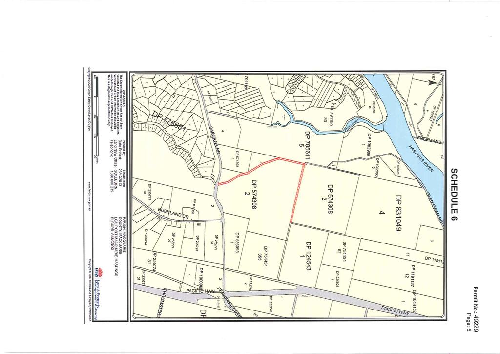
11 2.1 Crown Land Purchase Site In order to eliminate property fragmentation over the site, Hanson is proposing the closure and purchase of a parcel of Crown owned land (Figure 2), under the Roads Act Hanson currently holds an Enclosure Permit (number: 49229) under this Act. However the closure and purchase of this Crown land parcel will provide Hanson with the flexibility to expand operations in accordance with best site geology, site morphology, site topography, resource availably, and extraction ease. The illustrated Crown owned land parcel (Figure 2) is not included in the project extraction boundary as a component of the proposed expansion area, but is a significant component of the quarry expansion project. By reducing property separation, Hanson is provided with the opportunity to investigate resource extraction into the recently purchased northward Lot 2, DP This would be a necessary and significant factor in enabling Hanson to continue to provide suitable construction resources to facilitate state and regional development over the 30 year expected project life. Additionally the acquisition of said Crown owned land parcel would maintain adequate buffer zones between adjoining sites. Hanson proposes the closure and purchase of said Crown land parcel to increase public safety, maintain operational control, reduce external variables, and consequently reduce on and off-site safety risks. This plot is currently categorised as "Crown Road Enclosure". 10
12 3 Current Development Consent and Operations The site occupies 145ha. Of this total area, 6.5ha is occupied by the current quarry pit, 0.6ha by the crushing plant, 0.5ha by the administrative area, 1.8ha by the three dams and 2.2ha by the aggregate stockpile area. Site management facilities, including building, main access road, staff amenities block, site office, workshop, and materials storage shed are also located on the site. The remainder is native bushland. The resource in the quarry is approximately 55 million tonnes, translating to a 30 year quarry life. The quarry currently extracts a maximum 455, 000 tonnes per annum. The current site functions as mine plan that is operated and externally accredited to AS14001 (Environmental Management Systems), AS4801 (Safety Management Systems) and AS9001 (Quality Management Systems) management systems. 3.1 Operational Development Application The quarry currently operates under multiple approved Development Consents (DA). The first being, DA No. 1995/193, which was approved by PMHC on 19 November 1995, modified 7 January 2008, 18 November 2009 and 26 March 2014 under section 96 of the EP&A Act. Sancrox Quarry also operates under DA No. 2004/609, which was approved by Council on 10 January 2005, and modified under section 96 of the EP&A Act on 2 July Lastly Sancrox quarry operates under a third consent, DA 2006/497, which was approved by Council 11 December The amendment of DA 1995/0193 under section 96 the Environmental Planning and Assessment Act 1979 altered the pre-approved hours of operations issued by Council. The approved hours of operation under the modification to DA 1995/193 can be seen in Table 3 and are elaborated upon in the subsequent section of this document (Sect. 3.2). The hours of operation in DA 1995/193 also apply to DA 2004/ Hours of Operations and Employment Sancrox Quarry currently operates within the approved hours as seen in Table 3. Table 3: Approved Hours of Operation Approval Condition Approval Hours Day Normal operations 7:00am 5:00pm Monday to Friday Normal operations 7:00am 1:00pm Saturdays Additional activities including, truck movement into, around, and out of the Sancrox Quarry, 7:00am 11:00pm Monday to Friday, Saturdays, Sundays and Public Holidays as well as equipment loading Additional operations 11:00pm and 7:00am Up to 20 occasions. Currently there are fifteen (15) full time workers at Sancrox Quarry. Casual and contractors are employed on an as needed basis. 11
13 Full time positions are detailed below; Manager (one) Supervisor (one) Weighbridge (one) Fitter (one) Sales loader (two) Excavator (two) Crushing plant operator (one) Transport driver (six) Casual positions are detailed below; As required (generally up to two). Contractors As required 12

14 Figure 3: Current Infrastructure Area Source: Department of Lands, SIX Viewer 13

15 4 Proposed Project Approval for the current operations at Sancrox Quarry was granted by PMHC in Since this time the Sancrox Quarry has been operated by Hanson and is a significant local supplier of high quality hard rock aggregates to the region. The existing operations at Sancrox Quarry are depicted in Figure 3. The proposed project will involve extending the life of the quarry to 30 years, and increasing approved extraction limits of 175, 000m 3 (455, 000 tonnes) per annum as per both DA1995/0193 and DA2004/609 which was approved under section 96(2) of the Environmental Planning and Assessment Act 1979, to tpa. Hanson is seeking project approval for 30 years. Hanson is seeking planning approval to extend the currently approved extraction boundary, thereby resulting in a growth of the quarry footprint. The indicative quarry footprint is shown in Figure 4 below. The pink line depicts the proposed extraction limit (approximately 52.0 ha) and the orange line depicts the proposed infrastructure area (approximately 6.9 ha). This area includes the historically disturbed quarry footprint. Figure 4: Proposed Extraction Boundary 4.1 Land Closure and Purchase Site Hanson is proposing to close and purchase a section of Crown owned land to connect currently fractured land parcels under the Roads Act, This connectivity is required to facilitate the 14

16 orderly development of the quarry site, complete with the inclusion buffer zones, thereby allowing Hanson to continue to provide construction materials to meet regional and state development demands. To enable this purchase, it is proposed to subdivide Crown owned land parcel as per Figure 5. Additionally, quarry operations occur in close proximity to the locality of the Crown land site. The proposed extraction boundary, will involve further encroachment of quarry operations towards the depicted Crown land parcel (as per Figure 4 and Figure 5). The Company closely mitigates quarry operations to minimise the risk of injury to any personal on site. Hanson is unable to control public activity on this Crown land parcel, thereby increasing the potential of accidental harm to the public from quarrying activities. Hanson proposes the closure and purchase of said Crown land parcel to increase public safety, maintain operational control, reduce external variables, and consequently reduce on and off-site safety risks. Figure 5: Proposed Crown Land Acquisition Site Source: NSW Government, Lands and Property Information 15
17 4.2 Ancillary Infrastructure The proposed project will involve an upgrade and relocation of the existing infrastructure area including processing plant, offices, weighbridge, and workshop. Additionally the project includes the proposal for the construction of a concrete batching plant, concrete recycling facility, asphalt plant and pug mil on site. The concrete plant will supply concrete within the local markets. The plant will produce approximately 20,000m 3 of concrete each year. The plant infrastructure will be constructed on a concrete hard stand area and water runoff will be managed on site. The plant would consist of upright silo(s), incline conveyor belt, load bins, admixture bunded area, and batch room/amenities. Table 4 details the major components of the proposed project. Table 4: Current and Proposed Ancillary Infrastructure at Sancrox Quarry Major Project Components/Aspects Currently Approved Sancrox Quarry Proposed Project Quarry Life 20 years. 30 years. Limits on Production m 3 (455, 000 tonnes) per annum approved under section 96 of the Environmental Planning and Assessment Act 1979 as a modification to DA 1995/0193 and DA 2004/ tpa Quarry Footprint As shown on Figure 3. Extension of quarry pit as shown in Figure 4. Hours of Operation Concrete Batching Plant Quarry operates: - 7am 5pm Monday to Friday - 7am 1pm Saturday Truck movements and equipment loading: - 7am-11pm Monday Friday - 7am 1pm Saturdays, Sundays and Public Holidays. Operations are permitted between 11:00pm and 7:00am on a maximum of 20 occasions within a year. Not currently operating Blasting: 8am 5pm Monday to Friday Truck movements and equipment loading: 24 hours 7 days Quarry operations (incl. production and maintenance): 24 hours a day, 7 days a week 20, 000 m 3 per year Concrete Recycling Not currently operating 20, 000 tonnes per year 16
18 5 Stakeholder Consultation Hanson has an established presence in the PMHC region through the Company s existing operations at Sancrox Quarry and has developed relationships with the key stakeholders. These key stakeholders have been identified as adjoining land owners and local community groups that have targeted interests and concerns in relation to the quarry (i.e. along truck transit routes. Prior to project changes, stakeholders will be consulted to ensure key issues, concerns and apprehensions are identified and addressed in the Environmental Assessment and Environmental Impact Statement. To address community concerns, Hanson will continue to implement the existing community engagement practices, enquiry telephone line, and website. In addition to this existing Plan, Hanson will develop further engagement processes to ensure the project and local community can co-exist. The detailed engagement process will enable the community to be informed of project planning by providing a platform for comments and feedback to enable the identification of community needs and concerns. This will assist Hanson to target and address specific areas of community interest during project considerations throughout the environmental impact assessment and approval process. Hanson has informed certain stakeholders of the Company s intention to expand operations and will be updated as required during the assessment process. Additionally adjoining landholders will be individually informed of the proposed project, and told that there will be a formal channel for them to raise their concerns and provide comment. Consultation with the relevant government agencies will also be undertaken throughout the preparation of the EA to ensure key issues are identified and appropriately assessed in the Environmental Impact Statement. NSW Office and Environment and Heritage, Road and Maritime Services (RMS), NSW DP&E, Environmental Protection Authority, NSW Department of Trade and Investment, PMHC and other key government agencies will be communicated with where appropriate. It is expected that the Secretary s Environmental Assessment requirements will provide further guidance on applicable agencies requiring consultation. 6 Planning Considerations The proposed project will require development consent under Part 4, division 4.1 of the Environment Planning and Assessment Act 1979, following the commencement of the EP&A (Part 3A repeal). As administered by the Department of Planning and Environment. The project is proposed to be a State Significance Development, and is therefore considered under provisions of the State Environmental Planning Policy (State and Regional Development) The Minister for Planning and Environment, or their delegate, will be the consent authority for the development. The subject land is zoned RU1 Primary Production under the Hastings Local Environment Plan The proposed development is considered permissible within the zone subject to development consent in accordance with the Hastings Local Environment Plan 2011 (LEP 2011). Sancrox Quarry is currently operating under Environmental Protection Licence 5289, in accordance with Chapter 3 of the Protection of the Environment Operations Act The
19 proposed project will require an alteration under this licence as extraction limit exceeds the 100, 000 to 500, 000 tonne per annum approval on the current licence. Other approvals or variations to existing licences and approvals under the Protection of the Environment Operations Act 1997, Water Management Act 2000 and Roads Act 1993 are likely to be required for various components of the proposed project if approved. All relevant legislative requirements will be addressed in further detail in the EA. 6.1 State Planning Issues State Environmental Planning Policy (Mining, Petroleum, Production and Extractive Industries) 2007; Part 3 of this SEPP concerning, natural resource management, transport, resource recovery and rehabilitation will be included in the Environmental Impact Assessment. An assessment will be conducted under the consent authority to ensure the project conforms with this Policy. In addition to State Environmental Planning Policy (Major Projects) 2005, the following SEPPs apply to the project or over the Project Site. State Environmental Planning Policy No. 11 Traffic Generating Development (SEPP 11) Clause 7 of SEPP 11 requires that certain development applications be referred to the NSW Roads and Maritime Service (RMS), which was formally referred to as the Roads and Traffic Authority. Schedule 1 of this policy, hence, the project is to be referred to the RMS. State Environmental Planning Policy No. 33 Hazardous and Offensive Development (SEPP 33) Hazardous and offensive industries, and potentially hazardous and offensive industries, relate to industries that without the implementation of appropriate impact minimisation measures would, or potentially would, pose a significant risk in relation to the locality, to human health, life or property, or to the biophysical environment. A risk screening of the project will be performed in accordance with the document entitled Applying SEPP 33 2nd edition, (DUAP, 1997), however, as the only hazardous substances and dangerous goods to be used / stored on the Project Site would be restricted to well managed diesel fuel and other hydrocarbon products, the project is unlikely to classify as hazardous or potentially hazardous industry. State Environmental Planning Policy No. 44 Koala Habitat Protection (SEPP 44) Port Macquarie Hastings Local Government Area is identified in Schedule 1 of this policy as an area that could provide habitat for Koalas. SEPP 44 provides details on whether vegetation is classified as potential or core. Potential Koala habitat is described as areas of native vegetation where the trees of the types listed in Schedule 2 constitute at least 15% of the total number of trees in the upper or lower strata of the tree component". Core Koala habitat is defined as "land with a resident population of Koalas, evidenced by attributes such as breeding females (that is, females with young) and recent sightings of and historical records of a population". A detailed flora and fauna investigation will be undertaken as part of the Environmental Impact Assessment.
20 SEPP 44 does not apply to Major Projects that are being assessed as State Significant Development, however, SEPP 44 Koala habitat definitions may be used in the Biodiversity Assessment Report to determine potential and core Koala habitat areas for the study area. State Environmental Planning Policy No. 55 Remediation of Land (SEPP 55) SEPP 55 is not considered applicable given no area of the land within the Project Site is known to be contaminated. A contamination and land capacity assessment are anticipated to be required for the project. 7 Key Issues There are several key issues that have been identified as being potentially affected as a result of the proposed modification in extraction rate and expansion of the quarry footprint. These are; o o o o o o o o o o Ecological Issues Visual Impacts Noise and Blasting Impacts Air Quality Traffic and Transport Surface & Groundwater Waste Aboriginal and European Archaeology Socio-Economic Impacts Hazards 7.1 Ecology A detailed Ecological Impact Assessment will be undertaken for inclusion in the EIS to assess the impacts of the proposal on the ecology within the proposed disturbance area. These studies are expected include, but are not limited to: Biodiversity Assessment likely using the Framework for Biodiversity Assessment. Identifying the presence of any threatened species or endangered ecological communities and providing an assessment of proposed project impacts. Proposing mitigation measures to minimise project impacts on threatened species and their habitat. This will include an assessment of the effectiveness and reliability of the measures and any residual impacts after these measures are implemented. Assessing potential impacts on potential aquatic, riparian habitats groundwater dependent ecosystems. Assessing the impacts of clearing native vegetation on a regional context, especially pertaining to potential impacts on wildlife corridors. Assessing woodland remnants to the north, west and south, and the narrow strip of vegetation along the eastern boundary. Identifying the presence of any matters of national environmental significance (MNES) and assessing potential project impacts on these MNES. 7.2 Visual Impacts Previous studies suggest that the visual impacts of the proposed project will not significantly impede surrounding residential and public receptors. This is so because topography obscures
21 south and west views, and vegetation obscures views from the north and east. The proposed project will increase the quarry area and hence increase the potential for visual harm. Therefore a Visual Impact Assessment (VIA) will need to be conducted for inclusion in the EIS. A VIA will be conducted to assess potential impact to the visual amenity particularly on local sensitive receptors. The Visual Impact Assessment will include an assessment of surrounding residential and public viewing platforms. It is anticipated that the Visual Impact Assessment will be conducted using GPS mapping of receptors, three dimensional digital terrain modelling, and digital project overlays to identify visual harm of the proposed project Site. 7.3 Noise and Blasting Impacts The proposed project involves the continuation of existing quarry operations, which have the potential to cause detrimental noise impositions on the surrounding amenity. Environmental Resource Management Australia (ERM) s acoustic report composed in 2013 for the Sancrox Quarry Modification of Development Consent, Statement of Environmental Effects assessed operational, road traffic, and blasting and vibration, providing operational noise criteria targets. As the project includes a reasonable increase in annual production, an additional noise and blasting impact assessment will be undertaken in accordance with the requirements of the NSW Industrial Noise Policy (EPA 2000) to quantify background and predicted noise levels. This assessment will entail the following; Analysis and discussion of the existing noise environment in the proposed Project Area and surrounds; Prediction of the noise emissions for the proposed project; Assessment of the impact of the proposed project on surrounding sensitive receivers in accordance with the NSW Industrial Noise Policy; Assessment of any cumulative impacts associated with the proposed project and other significant local noise sources; Assessment of predicted blasting overpressure and vibration levels at potentially affected receivers; and recommendations relating to noise and blasting monitoring and management. 7.4 Air Quality The proposed project involves extending the current extraction boundary, which will alter the distribution of deposited dust, total suspended particulates and particulate matter (PM 10 ). Air quality sampling will be conducted in 2013 in conjunction with results presented by ERM s, Air Quality Assessment, included within Sancrox Quarry Modification of Development Consent, Statement of Environmental Effects. Maximum incremental ground level concentrations presented in Table 8.1 of said report will be used as reliable targets for the Air Quality Assessment for inclusion in the Sancrox Quarry Expansion EIS. The Air Quality Assessment is expected to involve the assessment of air characteristics using background monitoring results, emission level information and predictive computer modelling. Air samplers will be positioned at sensitive receptors to identify and quantify pollutants at the site in prevailing wind patterns. An air quality impact assessment will be undertaken to: Assess the existing/background air quality in the area.
22 Assess all activities and identify all activities likely to generate air impacts or have the potential to cause harmful effects on the environment including health and amenity, and all related environmental issues. Identify air pollution controls or mitigation measures for the operations to minimise air quality impacts. Assess air quality impacts from quarry activities on nearby receivers. Identify key emitted species including TSPs, odour, particulate matter (PM 10 ) and deposited dust and provide emission rates for those pollutants for the different activities, and determine the resultant ground level concentration of pollutants. 7.5 Traffic Traffic movements have been modelled in a Traffic Impact Assessment by TTM (2013), and are annexed to Sancrox Quarry Modification of Development Consent, Statement of Environmental Effects, prepared by ERM as a modification to DA 2004/609 of consent pursuant to Section 96 application of the Environmental Planning and Assessment Act A detailed Traffic Impact Assessment will need to be completed as part of the EIS to assess the traffic impacts of increasing the annual production limit on the local and regional road network and local amenity. The traffic impact assessment will involve the following: An assessment of the existing road transport systems including the identification of any transport constraints or issues. An assessment of traffic generation due to the proposed project and the likely impacts of this traffic on the existing transport networks. Documenting potential road transport issues for the proposed project including: o Level of service on the road network; o Physical condition of the roads related to the proposed project including capacity of the networks; o Road safety issues; and o Consideration of the cumulative transport impacts associated with this proposed project and other existing developments. The Traffic Impact Assessment will also include concrete batch vehicle movements. 7.6 Surface and Ground Water The project includes a significant expansion to the current pit in a lateral direction which will require groundwater and surface water modelling to identify any impacts of the project on the water systems. The water resources impact assessment is anticipated to include: Assess the potential impacts on surface water and groundwater; Investigate the management of process water; Assess the interaction of surface water and groundwater with the quarry water management system; Assess the feasibility of rehabilitation options in respect to water systems; and Include a predicted water balance. The Proponent has completed drill coring in three locations in the expansion area and will use these results to quantify the characteristics of the rock including the presence of any fractures

23 and permeability. Monitoring groundwater loggers has been installed as per Figure 6 to monitor groundwater level and temperature before during and after the expansion. Figure 6: Location of Monitoring Bore Holes Source: Google Earth 7.7 Waste Waste management for the proposed project will remain consistent with waste management strategies currently employed at Sancrox Quarry. The site follows the established hierarchy under the Waste Avoidance and Resource Recovery Act 2001 which assess waste resource management in accordance with the following hierarchy; 1. Avoidance including action to reduce the amount of waste generated. 2. Resource Recovery including reuse, recycling, reprocessing and energy recovery, consistent with the most efficient use of the recovered resources. 3. Disposal including management of all disposal options in the most environmentally responsible manner. Any minor changes will be identified in a Waste Impact Assessment.
24 7.8 Aboriginal Archaeology It is proposed that detailed studies will be undertaken as part of the formal EIS which will include: A review of relevant environmental information, past Aboriginal cultural heritage investigations and relevant statutory registers and inventories in order to identify areas of archaeological potential and known sites. Conducting and documenting Aboriginal cultural issues as set out in the Draft Guidelines for Aboriginal Cultural Heritage Impact Assessment and Community Consultation (DEC 2005) as well as The Burra Charter (The Australia ICOMOS charter for places of cultural significance 2013), Aboriginal Cultural Heritage Consultation Requirements for Proponents (OEH, April 2010), and Code of Practice for Archaeological Investigation of Aboriginal Objects in New South Wales (OEH 2010). Identifying the nature and extent of impacts on Aboriginal cultural heritage values across the Project Area. Identifying mitigation measures to minimise impacts on Aboriginal cultural values. This includes an assessment of the effectiveness and reliability of the measures and any residual impacts after these measures are implemented. Undertaking effective community consultation with Aboriginal communities in determining and assessing impacts, developing options and making recommendations. 7.9 Socio-Economic Impacts The project s socio-economic assessment is concerned with assessing and predicting the likely consequences of a project in both social and economic terms. While the economic assessment component emphasises the monetary effects of a proposal, the social impact assessment component is concerned with assessing benefits and costs in non-monetary terms. Previous socio-economic surveys undertaken at Sancrox Quarry indicate positive outcomes associated with Sancrox Quarry. The quarry provides integral economic resources for the Pacific Highway Upgrade, which is of state and national significance. Moreover the quarry has promoted regional development in the Port Macquarie Hastings local government area via its supply of pavement and road materials. The project directly employs 10 people, which has carry on socio-economic effects in the industry. Additionally the quarry supports economic growth of the region whilst implementing safeguards for noise, air quality and visual impact. These safeguards mitigate any detrimental impacts of the proposed project on the surrounding amenity. The quarry is situated in an area which is well removed from current and projected residential developments, thereby reducing potential quarry impact on the residential amenity and setting it aside as a regionally significant resource to the Port Macquarie Hastings Local Government Area. The Port Macquarie Hastings region has implemented various regional strategic planning instruments including (but not limited to); - Towards 2030, Community Strategic Plan
25 - Greater Port Macquarie Destination Management Plan - Port Macquarie-Hastings Urban Growth Management Strategy Mid North Coast Regional Strategy Regional infrastructure requirements identified in the State Infrastructure Strategy 2008/09 to 2017/18 The project will maintain alignment with the objectives of the aforementioned plans. 8 Conclusion Hanson s Sancrox Quarry has been operated by Hanson since 1998 during which time the Company has provided integral resources to facilitate regional and state development whilst maintaining and developing efficient operations to minimise detrimental environmental impacts on the Port Macquarie Hastings locality. The project seeks development approval to increase the annual extraction limit, and expand the quarry footprint, in order to accommodate a corresponding increase in quarry life to 30 years. To facilitate orderly quarry development and associated inclusion of buffer zones, Hanson proposes to acquire a Crown land parcel which currently fragments adjoining land lots. The expansion of Sancrox Quarry offers significant regional and state advantages. Hanson is determined to maintain and further develop a collegial relationship with regional development and the surrounding community.

26 Appendix 1 Enclosure Permit Sancrox Expansion Project Preliminary Environmental Assessment
27