Public Notice. Applicant: HSF Arlington, LLC Project No.: SWF Date: May 18, Name: Darvin Messer Phone Number:
|
|
|
- Harry Barker
- 5 years ago
- Views:
Transcription

1 Public Notice Applicant: HSF Arlington, LLC Project No.: SWF Date: May 18, 2017 The purpose of this public notice is to inform you of a proposal for work in which you might be interested. It is also to solicit your comments and information to better enable us to make a reasonable decision on factors affecting the public interest. We hope you will participate in this process. Regulatory Program Since its early history, the U.S. Army Corps of Engineers has played an important role in the development of the nation's water resources. Originally, this involved construction of harbor fortifications and coastal defenses. Later duties included the improvement of waterways to provide avenues of commerce. An important part of our mission today is the protection of the nation's waterways through the administration of the U.S. Army Corps of Engineers Regulatory Program. Section 10 The U.S. Army Corps of Engineers is directed by Congress under Section 10 of the Rivers and Harbors Act of 1899 (33 USC 403) to regulate all work or structures in or affecting the course, condition or capacity of navigable waters of the United States. The intent of this law is to protect the navigable capacity of waters important to interstate commerce. Section 404 The U.S. Army Corps of Engineers is directed by Congress under Section 404 of the Clean Water Act (33 USC 1344) to regulate the discharge of dredged and fill material into all waters of the United States, including wetlands. The intent of the law is to protect the nation's waters from the indiscriminate discharge of material capable of causing pollution and to restore and maintain their chemical, physical and biological integrity. Contact Name: Darvin Messer Phone Number:
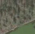
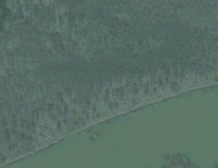
2 JOINT PUBLIC NOTICE U.S. ARMY CORPS OF ENGINEERS, FORT WORTH DISTRICT AND TEXAS COMMISSION ON ENVIRONMENTAL QUALITY SUBJECT: Application for a Department of the Army Permit under Section 404 of the Clean Water Act (CWA) and for water quality certification under Section 401 of the CWA to discharge dredged and fill material into waters of the United States (WOUS) associated with the construction of a mixed use development including a train station, commercial development, and associated parking in the city of Arlington, Tarrant County, Texas. APPLICANT: HSF Arlington, LLC c/o Jerry Reis 325 North St. Paul Street, Suite 3920 Dallas, Texas APPLICATION NUMBER: SWF DATE ISSUED: May 18, 2017 LOCATION: The proposed mixed use development would be located on a 75-acre tract of land containing Hurricane Creek and abutting wetlands, which drain to the West Fork of the Trinity River in the city of Arlington, Tarrant County, Texas. The proposed project would be located approximately at Latitude North and Longitude West on the Euless 7.5-minute USGS quadrangle map in the USGS Hydrologic Unit Lower West Fork Trinity River (Attachment 1). PROJECT DESCRIPTION: The applicant proposes the discharge of approximately 75,000 cubic yards of fill material into approximately 5.18 acres of WOUS in conjunction with the construction of a mixed use development including a train station, commercial development and associated parking (Attachment 3). Approximately 4.90 acres of forested and 0.23 acre of emergent wetlands along with 698 linear feet (0.05 acre) of ephemeral stream are proposed to be filled by the project. No temporary impacts are proposed. The entire development footprint would require filling (approximately 10 in elevation) to establish construction site(s) above the 100-year floodplain elevation and to meet grade at vehicular access points. The applicant s stated project purpose is to construct a train station based transit oriented development to improve and diversify the transportation network in the Dallas-Fort Worth Metroplex, specifically in Arlington, associated with the Viridian residential development which has a projected build-out population of 15,000. The proposed project site is the last available location for a train station and associated mixed-use development between Dallas and Ft. Worth on the Trinity Railway Express (TRE) line. The applicant s stated secondary purpose is to provide a mixed-use development consisting of a convenience retail store, coffee shop, and office complex. Access to the project area would be from the west connecting with Collins Street (Route 157) and Mosier Valley Road and from the south by extending Cascade Sky Road across Hurricane Creek between the Viridian development and the project area. 2
3 The proposed Cascade Sky Road bridge over Hurricane Creek would consist of three 40 wide Conspan culverts. The natural stream bottom would be preserved. The proposed bridge is located to align with Cascade Sky Road in Viridian to the south and the abandoned raised road bed to the north on the subject parcel. The abandoned raised road bed on the subject parcel is proposed to be widened to accommodate two way traffic and a 4:1 embankment on either side of the proposed road. Cascade Sky Road would continue north along the old road bed to the train station and then turn west, where it would connect with Mosier Valley Road. The proposed development footprint is located at the northwest corner of the project area to minimize filling of WOUS to the south and east. Materials and Methods: Cascade Sky Road bridge would be constructed of precast concrete. Cascade Sky Road and the parking lot will be constructed of asphalt or concrete on clean fill. Cascade Sky Road bridge would be constructed in the dry by using coffer dams, pumps, and diversion culverts to divert water away from the work zone. Cascade Sky Road and the development footprint would be constructed using typical earth moving equipment likely to include graders, backhoes, bulldozers, and dump trucks. Preserved wetlands would be protected with silt fence and construction barriers during all stages of construction. All construction impacts and stockpiling of equipment or materials would take place on upland areas off site or within the area permitted to be filled on site. EXISTING CONDITIONS: The project area is entirely wooded except for a portion of emergent and open water wetland at the south east corner of the property. The project area consists of upland forest to the north and forested wetland to the south. The upland forest is characterized by cedar elm (Ulmus crassifolia), sugarberry (Celtis laevigata), and pecan (Carya illinoiensis) in the over story; a shrub layer of coral berry (Symphoricarpos orbiculatus), poison ivy (Toxicodendron radicans), wild grape (Vitus rotundifolia), and Japanese honeysuckle (Lonicera japonica); and an herbaceous layer of sea oats (Chasmanthium latifolium). The forested wetland is characterized by sugarberry, green ash (Fraxinus pennsylvanica), and American elm (Ulmus americana) in the over story and green ash and the occasional buttonbush (Cephalanthus occidentalis) in the shrub layer. The ground layer consists of bare soil, Cherokee sedge (Carex cherokeensis) along the drier edges of the wet woods, and crow-foot sedge (Carex crus-corvi) in the wettest areas. An abandoned railroad bed runs approximately north-south through the project area. A wetland delineation completed on October 23-24, 2013, identified five potentially jurisdictional wetlands totaling acres, and 1,248 linear feet (0.09 acre) of ephemeral stream (Attachments 3-5). PROPOSED IMPACTS AND MITIGATION: Proposed impacts to WOUS would total 5.18 acres. Approximately 4.90 acres of forested and 0.23 acre of emergent wetlands along with 698 linear feet (0.05 acre) of ephemeral stream are proposed to be filled by the project. Compensatory mitigation proposed consists of the purchase of in-kind credits from an approved mitigation bank servicing the project area. ALTERNATIVES TO THE PROPOSED PROJECT: The applicant evaluated alternative sites as part of their site selection process and chose the proposed project area due to its adjacency to the TRE rail line while also providing the appropriate spacing between stations. USACE has not yet fully evaluated the applicant s alternatives analysis. This is the last available location for a train station and associated 3
4 mixed-use development that would achieve the appropriate spacing for stops between Dallas and Ft. Worth on the TRE line. The applicant explored multiple design scenarios to create an economically viable residential development in concert with the surrounding environmental components of the site. However due to the location of the floodplain, out-parcels and WOUS, none of the alternatives avoided the impacts to WOUS while also providing the minimum acreage necessary to accommodate the station, parking, turnaround for buses, and associated mixed-use development. The TRE line is the north property area boundary and includes waters along the toe of the track outslope. There is no way to access the TRE line without crossing the WOUS. The west property boundary is wetland except for a narrow piece of upland that will accommodate access to North Collins Street. The south property boundary consists of Hurricane Creek which must be crossed to access the property from the south. The west property boundary consists of a private industrial parcel, as well as Hurricane Creek. In summary, there are no on-site alternatives that would result in no discharges of dredged or fill material into WOUS. Three possible alternatives were developed and analyzed by the applicant. While Alternative 1 would have the least impact on the wetlands, it would only be accessible via the state road to the west (see Table 1 below and Attachment 4). Of the remaining two options the Applicant s Preferred Alternative and Alternative 2 (see Attachments 3 & 5 respectively), the applicant selected the Applicant s Preferred Alternative due to its substantial reduction in impacts to wetlands (as compared to Alternative #2). Applicant s Preferred Alternative Alternative #1 Alternative #2 Project Area acres acres acres Developed Area acres acres acres Wetlands Filled 5.13 acres 3.12 acres acres Wetlands Remaining acres acres acres In order to minimize impacts, the existing north/south access road corridor would be used in order to minimize grading impacts to WOUS elsewhere on the site. The proposed Cascade Sky Road bridge over Hurricane Creek would be constructed over three 40 wide Conspan culverts. The natural stream bottom would be preserved. Appropriate precautions would be taken during construction to prevent the flow of sediment and pollutants into nearby waters. Preserved wetland and upland areas would be connected to Viridian s open space areas to the south and dedicated to the City of Arlington and River Legacy as permanent open space. It is the intent of Hatton Sumners Foundation and Viridian that board walks and trails be constructed in these preserved or created wetland areas for environmental education and passive recreation. PUBLIC INTEREST REVIEW FACTORS: This application will be reviewed in accordance with 33 CFR , the Regulatory Program of the U. S. Army Corps of Engineers (USACE), and other pertinent laws, regulations, and executive orders. Our evaluation will also follow the guidelines published by the U. S. Environmental Protection Agency pursuant to Section 404(b)(1) of the CWA. The decision whether to issue a permit will be based on an evaluation of the probable impact, including cumulative impact, of the proposed activity on the public interest. That decision will reflect the national concerns for both protection and utilization of important resources. The benefits which reasonably may 4
5 be expected to accrue from the proposal must be balanced against its reasonably foreseeable detriments. All factors which may be relevant to the proposal will be considered, including its cumulative effects. Among the factors addressed are conservation, economics, aesthetics, general environmental concerns, wetlands, historic properties, fish and wildlife values, flood hazards, floodplain values, land use, navigation, shore erosion and accretion, recreation, water supply and conservation, water quality, energy needs, safety, food and fiber production, mineral needs, considerations of property ownership, and, in general, the needs and welfare of the people. The USACE is soliciting comments from the public; federal, state, and local agencies and officials; Indian Tribes; and other interested parties in order to consider and evaluate the impacts of this proposed activity. Any comments received will be considered by the USACE in determining whether to issue, issue with modifications, or conditions, or deny a permit for this proposal. To make this decision, comments are used to assess impacts on endangered species, historic properties, water quality, general environmental effects, and the other public interest factors listed above. Comments are used in the preparation of an Environmental Assessment and/or an Environmental Impact Statement pursuant to the National Environmental Policy Act. Comments are also used to determine the need for a public hearing and to determine the overall public interest of the proposed activity. STATE WATER QUALITY CERTIFICATION: This project would result in a direct impact of greater than three acres of waters of the state or 1,500 linear feet of streams (or a combination of the two is above the threshold), and as such would not fulfill Tier I criteria for the project. Therefore, Texas Commission on Environmental Quality (TCEQ) certification is required. Concurrent with USACE processing of this Department of the Army application, the TCEQ is reviewing this application under Section 401 of the Clean Water Act, and Title 30, Texas Administrative Code Section to determine if the work would comply with State water quality standards. By virtue of an agreement between the USACE and the TCEQ, this public notice is also issued for the purpose of advising all known interested persons that there is pending before the TCEQ a decision on water quality certification under such act. Any comments concerning this application may be submitted to the Texas Commission on Environmental Quality, 401 Coordinator, MSC-150, P.O. Box 13087, Austin, Texas The public comment period extends 30 days from the date of publication of this notice. A copy of the public notice with a description of the work is made available for review in the TCEQ's Austin Office. The TCEQ may conduct a public meeting to consider all comments concerning water quality if requested in writing. A request for a public meeting must contain the following information: the name, mailing address, application number, or other recognizable reference to the application; a brief description of the interest of the requestor, or of persons represented by the requestor; and a brief description of how the application, if granted, would adversely affect such interest. ENDANGERED AND THREATENED SPECIES: The USACE has reviewed the U.S. Fish and Wildlife Service's latest published version of endangered and threatened species to determine if any may occur in the project area. The proposed project would be located in Tarrant County, Texas where the whooping crane (Grus americana), least tern (Sterna antillarum), red knot (Calidris canutus rufa)and piping plover (Charadrius melodus) are known to occur or may occur as migrants. The whooping crane and least tern are endangered species and the red knot and piping plover are threatened species. Our initial review indicates that the proposed work would have no effect on federally-listed endangered or threatened species. NATIONAL REGISTER OF HISTORIC PLACES: The USACE has reviewed the latest complete published version of the National Register of Historic Places and found no listed properties to be in the 5
6 project area. However, presently unknown scientific, archaeological, cultural or architectural data may be lost or destroyed by the proposed work under the requested permit. FLOODPLAIN MANAGEMENT: The USACE is sending a copy of this public notice to the local floodplain administrator. In accordance with 44 CFR part 60 (Flood Plain Management Regulations Criteria for Land Management and Use), the floodplain administrators of participating communities are required to review all proposed development to determine if a floodplain development permit is required and maintain records of such review. SOLICITATION OF COMMENTS: The public notice is being distributed to all known interested persons in order to assist in developing fact upon which a decision by the USACE may be based. For accuracy and completeness of the record, all data in support of or in opposition to the proposed work should be submitted in writing setting forth sufficient detail to furnish a clear understanding of the reasons for support or opposition. PUBLIC HEARING: Prior to the close of the comment period any person may make a written request for a public hearing setting forth the particular reasons for the request. The District Engineer will determine whether the issues raised are substantial and should be considered in his permit decision. If a public hearing is warranted, all known interested persons will be notified of the time, date, and location. CLOSE OF COMMENT PERIOD: All comments pertaining to this Public Notice must reach this office on or before June 19, 2017, which is the close of the comment period. Extensions of the comment period may be granted for valid reasons provided a written request is received by the limiting date. If no comments are received by that date, it will be considered that there are no objections. Comments and requests for additional information should be submitted to ; Regulatory Division, CESWF-DE-R; U. S. Army Corps of Engineers; Post Office Box 17300; Fort Worth, Texas You may visit the Regulatory Division in Room 3A37 of the Federal Building at 819 Taylor Street in Fort Worth between 8:00 A.M. and 3:30 P.M., Monday through Friday. Telephone inquiries should be directed to (817) Please note that names and addresses of those who submit comments in response to this public notice may be made publicly available. DISTRICT ENGINEER FORT WORTH DISTRICT CORPS OF ENGINEERS 6

7


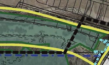


8 Bike/Ped Trail Wall tation Train S Commercial Mixed Use Residential Project Boundary P P P Property Line Proposed Contour Existing Contour Train Station Bus Station Impacted Wetland P Preseved Wetland Impacted Ephemeral Stream Project Area: acres Developed Area: 17.2 acres Wetlands Impacted: 5.13 acres Wetlands to Remain: acres Required Fill Volume: 218,200 CY Fill in Wetlands: 75,456 CY fill Planned Connection to Veloweb Trail ATTACHMENT 2 Hatton Sumners Parcel Preferred Alternative N 300 SHEET 2

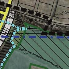
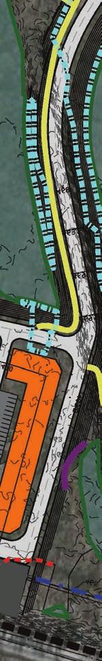
9 ATTACHMENT 3 PROPOSED PREFERRED ALTERNATIVE IMPACTS TO WATERS OF THE US 3
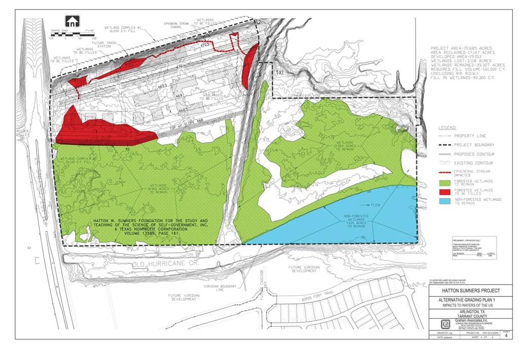
10 4
11 5
12 ATTACHMENT 6 PROPOSED PREFERRED ALTERNATIVE CULVERT DETAIL SHEET 6
13 ATTACHMENT 7 PROPOSED PREFERRED ALTERNATIVE GRADING CROSS-SECTIONS SHEET 7